


Introduction
Dudh Koshi basin in eastern Nepal is one of the country’s largest and most important basins in terms of glaciers and glacial lakes, and probably the most densely glacierized region of Nepal (Reference Bajracharya, Mool and ShresthaBajracharya and others, 2007). The glaciers extend to latitude 27˚38005" N and 4206ma.s.l., although the termini of most are at about 5000ma.s.l. The largest glacier in this basin is Ngojumba Glacier with an area of 82.61 km2; however, the largest glacier in Nepal is Kanchenjunga Glacier with an area of 94.52 km2. Changes in mountain glaciers are among the best natural indicators of climate change (Reference OerlemansOerlemans, 1994;Reference HoughtonHoughton and others, 2001) and there has been a significant impact on this high-mountain glacial environment. The glaciers are melting rapidly (Reference Fujita, Kadota, Rana, Kayastha and AgetaFujita and others, 2001), leading to the formation of new glacial lakes, the expansion of existing moraine-dammed lakes and the potential for glacial lake outburst floods (GLOFs) Reference Watanabe, Ives and Hammond(Watanabe and others, 1994). Most of the lakes, above 3500ma.s.l., formed in response to warming temperatures during the second half of the 20th century (Reference Yamada and SharmaYamada and Sharma, 1993; Reference Mool, Bajracharya and JoshiMool and others, 2001). The largest of the lakes is Imja Tsho with an area of about 0.95 km2, recorded as one of the fastest-growing lakes in the entire Himalaya (Reference Bajracharya, Mool and ShresthaBajracharya and others, 2007). Understanding the response of glaciers and glacial lakes to rising temperatures is an essential aspect of planning water resources as well as managing the potential for GLOF disasters.
Methods
The threshold ratio from Thematic Mapper (TM) band 4 and 5 images has been used widely for glacier delineation. This technique is simple, robust and accurate and has been applied to the 2000 Swiss glacier inventory and others (Reference Sidjak and WheateSidjak and Wheate, 1999; Reference AlbertAlbert, 2002; Reference PaulPaul, 2002; Reference Paul, Kääb, Maisch, Kellenberger and HaeberliPaul and others, 2004; Reference Bolch, Buchroithner, Peters, Baessler and BajracharyaBolch and others, 2008). Although the overall delineation of glaciers was carried out using this method, manual digitizing of sources from different years was used for the specific analysis of glacier change presented here: topographic maps (1960s), Landsat Multispectral scanner (MSS) (1976), Landsat TM (1992), Landsat Enhanced TM Plus (ETM+) (2001) and Advanced Land Observing Satellite (ALOS) (2007). Due to limitations in the remote-sensing imagery (e.g. shadows, coarse resolution), the number of valley glaciers studied to identify their retreat rate was limited to 22. Glacier length was obtained in the geo-referenced images from the difference between the highest and lowest elevations. As it was difficult to identify the smaller lakes in the coarse-resolution satellite images (Reference Bolch, Buchroithner, Peters, Baessler and BajracharyaBolch and others, 2008), the number of small erosion and supraglacial lakes decreased significantly compared with the 1960s. However, the area of Imja Tsho, derived from a manual delineation based on the 2000 Landsat scene, was 0.77 km2, whereas its area derived from a classification of the same Landsat scene was 0.766 km2 (Reference Bolch, Buchroithner, Peters, Baessler and BajracharyaBolch and others, 2008), indicating some consistency between the two methods.
Glaciers and Glacier Retreat
The number of glaciers mapped in the basin was 278 with a total area of 482 km2 and an ice volume of 51 km3 (Reference Mool, Bajracharya and JoshiMool and others, 2001). Although they are located in the high mountains (Fig. 1), 40 glaciers, accounting for 70% of the glacierized area, extend down into the valley. Ngojumba, Khumbu, Bhote Koshi and Hungu glaciers are the principal glaciers in the Dudh Koshi basin and have areas of 82.61, 45.39, 35.63 and 22.91 km2, respectively. The average minimum retreat rate was 10ma–1, observed on Langdak, West Lhotse, Lhotse and Setta glaciers. Imja Glacier retreated at 34ma–1 from 1962 to 2000, a rate that increased to 74ma–1 from 2000 to 2007, giving an overall average retreat rate of 59 ma–1; it is now one of the fastest-retreating glaciers in the Himalaya. Other rapidly retreating glaciers are West Chamiang and Ombigaichain (Table 1; Fig. 2). In general, glaciers have been shrinking and retreating faster in the present decade (2000–07); Reference Khromova, Dyurgerov and BarryKhromova and others, 2003; Reference Paul, Kääb, Maisch, Kellenberger and HaeberliPaul and others, 2004).
Table 1. Retreat rate of valley glaciers in the Dudh Koshi basin
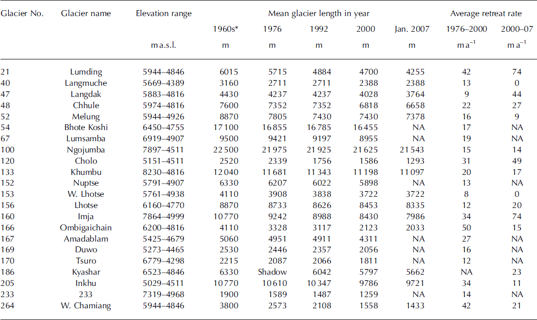

Fig. 1. Change in glaciers in the Dudh Koshi basin from the 1960s to 2000.
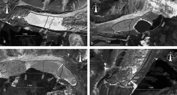
Fig. 2. Examples of glacier retreat and lake expansion from the Dudh Koshi basin: (a) Imja Glacier and Tsho; (b) glacier 262 (lake 464) in Hungu valley; (c) Lumding Glacier and Tsho; (d) Khumbu Glacier.
Glacial Lakes and Lake Activity
There are 473 glacial lakes >0.003km2 situated above 3500ma.s.l. in the Dudh Koshi basin (Reference Mool, Bajracharya and JoshiMool and others, 2001). The most important of these are Lumding Tsho, Dig Tsho, Imja Tsho, Tam Pokhari, Dudh Pokhari, Hungu and Chamiang.
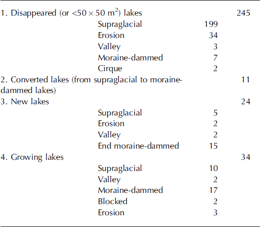
In a recent study, Reference Bajracharya and MoolBajracharya and Mool (2005) mapped 296 lakes from 2001 Landsat ETM+. They found that the lakes that had disappeared were mostly the supraglacial and erosion lakes. Most of the former were either too small to map (Reference Bolch, Buchroithner, Peters, Baessler and BajracharyaBolch and others, 2008) or had disappeared; some had been transformed into moraine-dammed lakes. While there had been a 37% decline in the number of lakes, the total area of lakes increased by 21%, due to the proliferation of moraine-dammed lakes. Of the major lakes (defined as >0.02km2), 34 were increasing in size and 24 new ones had appeared. The latter consisted of 15 moraine-dammed lakes, five supraglacial lakes, two valley lakes (lakes in the flood plain) and two erosion lakes (lakes on the valley slopes) (Table 2). Areas of these major glacial lakes, which lie at 4349–5636ma.s.l., ranged from 0.021 to 0.848 km2.
Table 2. State of glacial lakes in the Dudh Koshi basin (1960–2000)
The fast and continuous retreat of glaciers and growth of glacial lakes highlights the need to monitor glaciers and glacial lakes for the sound management of water resources. However, study of this phenomenon is a challenge because of the limits imposed by high altitude, the rarefied atmosphere, the remoteness of many of the locations and the short mapping season.
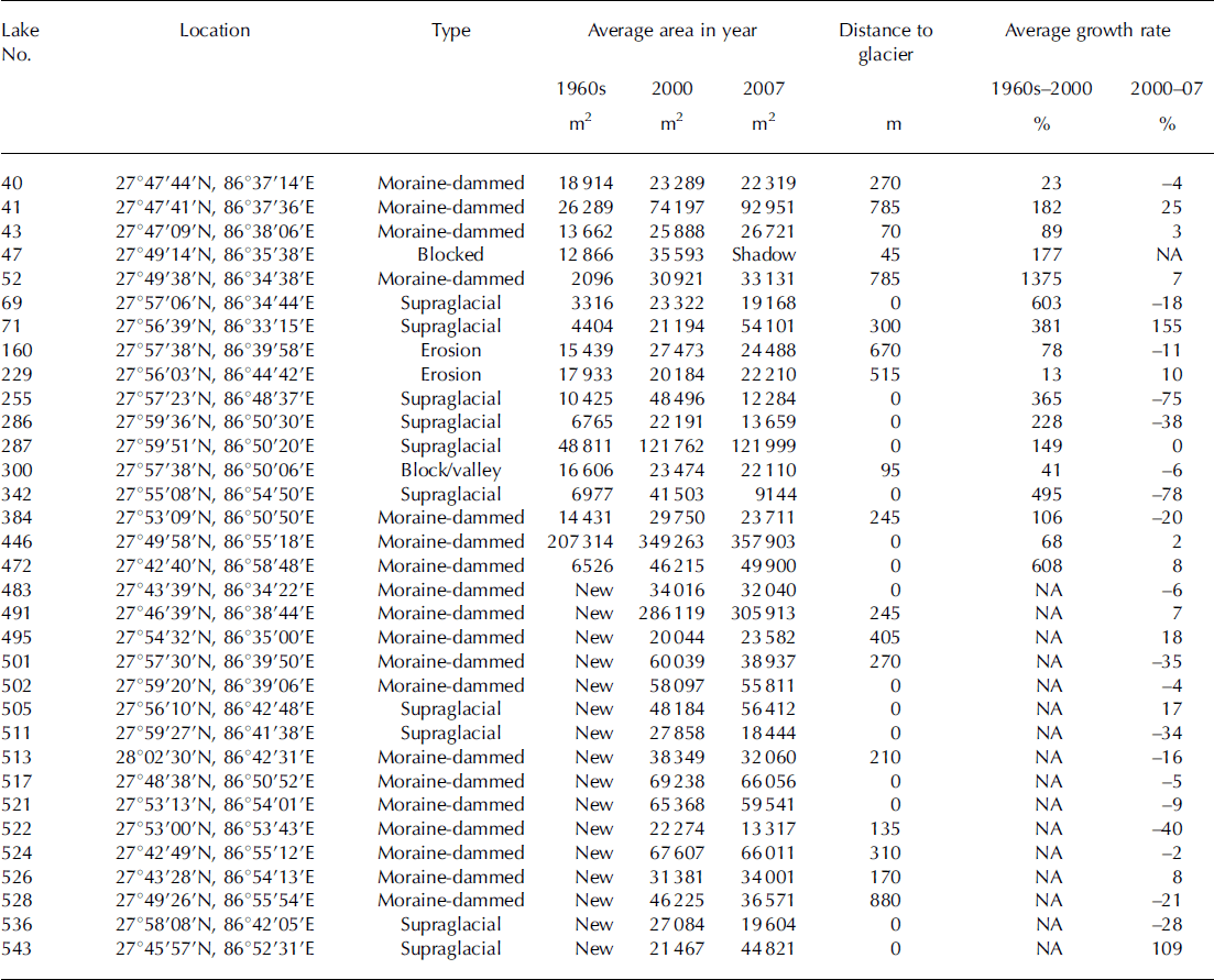
This is partly reflected in Table 3 which shows the growth rate of the lakes. From 2000 to 2007 the values are mostly negative because the image used for the analysis was from January 2007, a time of the year when most of the lakes at high altitude are frozen and at their minimum extent; however, some (e.g. lakes 71 and 543) showed significant growth.
Table 3. Activity of glacial lakes in the Dudh Koshi basin
Potentially Dangerous Glacial Lakes
Rapid retreat of glaciers increases run-off, contributes to the growth of glacial lakes and converts some supraglacial lakes to moraine-dammed lakes (Reference Hambrey, Quincey, Glasser, Reynolds, Richardson and ClemmensHambrey and others, 2008). These lakes tend to breach the weak and unstable loose moraine dam (Reference Yamada and SharmaYamada and Sharma, 1993; Reference Watanabe, Kameyama and SatoWatanabe and others, 1995), with catastrophic impacts downstream. Amongst the numerous glaciers and glacial lakes, the basin includes 12 potentially dangerous glacial lakes, the largest number in any sub-basin of Nepal, all of which (except lake 444) are dammed by loose and unstable moraine. Of the potentially dangerous glacial lakes identified (Table 4), three (lakes 422, 442 and 462) have remained at approximately the same size, one (lake 444) dried up in 2001 but subsequently reappeared, Tam Pokhari (lake 399) and Dig Tsho (lake 55) have a GLOF history, while the remaining six lakes (28, 350, 449, 459, 464 and 466) are growing. Imja Tsho (lake 350) is one of the fastest-growing lakes in the Himalaya.
Table 4. Status of potentially dangerous glacial lakes in the Dudh Koshi basin in 2007
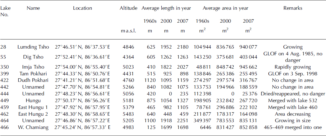
Lake 444 was identified by Reference Mool, Bajracharya and JoshiMool and others (2001) as a potentially dangerous glacial lake in 2000, but later that year had dried up or completely drained, reappearing again in 2007 Reference Bajracharya, Mool and Shrestha(Bajracharya and others, 2007) with an area of 25 376m2 (Table 4). It is a valley lake separated from the glacier. The risk of a GLOF from lake 444, compared with other lakes in the Dudh Koshi basin is considered to be sufficiently small that it should be removed from the list.
Dig Tsho (lake 55) had an outburst event in 1985 after which the lake area was reduced to 0.3 km2 with maximum depth >10m (more details are given below). The lake is surrounded by thick moraine on two sides, the steep-sloping Langmoche Glacier to the west and the lake outlet to the east. Analysis of temporal satellite images and field observations shows that the extreme end of the lake abuts the steep snout of Langmoche Glacier and there is no possibility for further expansion of the lake. As the present lake outlet is at the same level as the bed of the Langmoche river (Fig. 3), it can be concluded that Dig Tsho is no longer a potentially dangerous lake, as indicated in the 2001 inventory by the International Centre for Integrated Mountain Development (ICIMOD) and United Nations Environment Programme (UNEP).

Fig. 3. Dig Tsho is no longer a threat, as the lake outlet and river bed are at the same level. (a) Dig Tsho in April 2008. (b) Outlet of Dig Tsho and Langmoche river bed.
Glacial Lake Outburst Floods
Fast glacier retreat during the past decade has resulted in the rapid accumulation of meltwater in most of the moraine-dammed lakes in the basin, has increased their potential energy and reduced the shear strength of the damming material. Ultimately the loose-moraine dam will be breached, causing a GLOF (Reference IvesIves, 1986; Reference Zimmermann, Bischel and KeinholzZimmermann and others, 1986; Reference YamadaYamada, 1998; Reference Richardson and ReynoldsRichardson and Reynolds, 2000; Reference Mool, Bajracharya and JoshiMool and others, 2001; Reference KattelmannKattelmann, 2003). A number of GLOFs have already been reported in this region (Reference Zimmermann, Bischel and KeinholzYamada and Sharma, 1993; Reference MoolMool, 1995; Reference Reynolds, Maund and EddlestonReynolds, 1998; Reference YamadaYamada, 1998,Reference Yamada2000; Reference Mool, Bajracharya and JoshiMool and others, 2001; Reference Bajracharya, Mool and ShresthaBajracharya and others, 2007), such as the Nare GLOF (1977), the Dig Tsho GLOF (1985), the Tam Pokhari GLOF (1998) and one from lake 458/459 (associated with glacier 260) inferred from satellite imagery.
Only the Dig Tsho GLOF is well documented. Reference Vuichard and ZimmermannVuichard and Zimmermann (1987) reported that a 10–20x104m3 ice mass dislodged itself from the overhanging Langmoche Glacier and plunged into the lake, inducing a dynamic wave. The flood began in the early afternoon and lasted for 4–6 hours. The peak flood was estimated at 1600 m3s–1, but Reference Cenderelli and WohlCenderelli and Wohl (2001, Reference Cenderelli and Wohl2003) consider the peak discharge to be of the order of 2350 m3 s–1. The mean velocity of the surge front was 4–5m3 s–1 Reference Vuichard and Zimmermann(Vuichard and Zimmermann, 1987). Multiple surges were also reported; for example, the bridges at the villages of Jorsalle, Phakding and Jubing were not destroyed until 30–90 min after the passage of the initial surge. The most significant impact of this GLOF was the complete destruction of a new hydropower station at Thamo and about 30 houses, and the loss of 14 bridges between Mingbo and Jubing. The social, economic and environmental consequences of this GLOF were devastating. Because of the destruction of forest and inundation of cultivable land, villagers lost their subsistence base. The erosion from the surge along the river valley left active scars where further erosion was accelerated by wind, snow, rain and undercutting by the river. Even though Dig Tsho stabilized, the settlements, cultivated land and forests are still at threat from landslides and further erosion.
The past record shows that at least one GLOF event occurs every 3–10 years in the Himalayan region (Reference Bajracharya, Mool and ShresthaBajracharya and others, 2008), but with rising temperatures and more variability in the climate the frequency of GLOF events is expected to increase in the coming years.
Conclusions
The Dudh Koshi basin is the largest glacierized basin in Nepal. It has 278 glaciers of which 40, amounting to 70% of the area, are valley-type. Almost all the glaciers are retreating at rates of 10–59ma–1, but the rate for some has accelerated during the last half-decade to 74 ma–1. This fast and continuous retreat of glaciers has resulted in a proliferation of major glacial lakes to 34 and the creation of 24 new ones at 4349–5636ma.s.l. The basin is threatened by 12 potentially dangerous glacial lakes, but following further fieldwork two of these can now be removed from the list. Expanding glacial lakes may pose additional dangers in the near future, so adequate monitoring of glaciers and their lakes is vital for the sound management of water resources and disaster mitigation. A major challenge is how to accomplish this, considering the limits imposed by high altitude, the rarefied atmosphere, the remoteness of most locations and the short mapping season.


