


Introduction
In the early days of Quaternary studies in the Antarctic Peninsula region (including the South Shetland Islands and the islands in the westernWeddell Sea), it was generally-believed that the post-Last Glaciol Maximum (Wiscon-sinan, Weichselian, etc.) deglaciation had a timing similar to that in the Northern Hemisphere. The onset of déglaciion of the presently ice-free areas was assumed to have begun before 10 000 BP, and the oldest isostatically elevated sediments related to the deglaciation were dated to about 9000 BP (e.g. Reference John and SugdenJohn and Sugden, 1971; Reference Sugden, John and Van Zinderen BakkerSugden and John, 1973). These ideas prevailed until the beginning of this decade (e.g. Clappcrton, 1990), although hints of a more complicated picture had been published several years before (Reference Rabassa, Evenson, Schlüchter and RabassaRabassa, 1983, Reference Rabassa, Menzies and Rose1987).
Work carried out on land in the South Shetlands and on the islands in the western Weddell Sea during the 1980s and 1990s suggests a different deglaciation pattern than “the Northern Hemisphere concept”. Studies of Glaciol deposits and their relation to isostatically elevated marine sediments, and of lake-sediment and moss-bank cores, suggest that (1) the initial deglaciation of the presently ice-free lowland areas in the Antarctic Peninsula region took place gradually between about 9000 and 5000 l4C years BP, and (2) that a diinct but rather short-lived Glaciol readvancc culminated around or shortly after 5000 BP, followed (3) by the Holocene climatic optimum ("hypsithermal") between about 4000 and 3000 BP. Thereafter, (4) climate gradually approached prent conditions, as illustrated by a number of mostly rtricted neoglaciol oscillations, including a correlative of the Northern Hemisphere's Little Ice Age readvancc.
It also seems that most of the data which were earlier interpreted according to the “Northern Hemisphere coept” may be fit led into the new paradigm. This is especially the case when the empirically derived marine reservoir-effect correction of -1200 years (e.g. Reference Gordon and HarknessGordon and Harkncss, 1992) is applied, instead of the smaller corrections (700-850 years) used in earlier works.
The present paper gives a brief overview of the available terrestrial dataset, and tries to put some of the “older” data into the modern concept.
Table 1. Radiocarbon datings regarded as closely postdating the last deglaciation of different areas in the northern Antaric Peninsula region (Fig. 1). The dates on marine organisms are corrected for a reservoir effect of -1200 years (Gordon and Harkness, 1992)
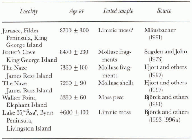

Fig. 1. Map of the northern Antarctic Peninsula region, showing 14C dates regarded as closely postdating the deglaciation in different areas.
The Deglaciation
Recently published land-based studies of the post-Last Glaciol Maximum deglaciation in the Antarctic Peninsula region are from three main areas: (1) Fildes Peninsula on King George Island (e.g. Reference MäusbacherMäusbacher, 1991), (2) Byers Pinsula on Livingston Island (e.g. Björck and others, 1996a), both in the South Shetland Islands; and (3) James Ross Island in the western Weddell Sea (Ingólfsson and others, 1992; extended and updated by Hjort and others, 1997). The oldest reliable 14C datings from the region (see under James Ross Island, below) are listed in Table 1 and indicated in Figure I.
Fildes Peninsula
The Fildes Peninsula studies (Mäusbacher, 1991, e.g. Fig. 72) are based on 14C-dated lake-sediment cores. They indicate a slow and gradual deglaciation of this lowland area (the send largest in the South Shetlands, after Byers Peninsula) between about 9000 BP (the oldest dating is about 8700 BP, see Table 1) and 5500 BP. During that time, sea level never stood above 22 m, and it took the ice front more than 3000 years to retreat 5 km! Around 5000 BP the minerogenic component in the lake sediments distinctly increased. This is interpreted as the result of renewed Glaciol activity, which lasted until aboul 4000 BP.
Sugden and John's (1973) oldest deglaciation date from the South Shetlands, from nearby Potter's Cove on King George Island (detailed description in John and Sugden, 1971), was taken as evidence for a deglaciation around 9000 BP. However, when using a -1200 years reservoir coection, that date becomes only about 8500 BP (table 1).
Mäusbacher (1991) also dated a distinct 16 m shoreline on Fildes Peninsula (part of the 15-20 m main Holocene beach level in the region) to about 6000 BP, which roughly fits with the approximately 5400 UP age of the 18 m level in Potter's Cove obtained when using the -1200 years correion on Clappcrton and Sugden's (1988) original date.
Byers Peninsula
The oldest deglaciation date from Byers Peninsula, about 4600 BP (Björck and others, 1993, 1996a), is also from lake sediments. The cores from this area show that the “postglial” marine limit here lies below 35 m. Deglaciation preeded gradually until most of the approximately 6 km wide ( in the direction the glacier withdrew) peninsula was ice-free by aboul 3000 BP, and the retreat was faster than on Fildes Peninsula during the earlier part of the Holocene. The ice front eventually withdrew to somewhere behind its present limit, as shown by a whale bone transported foards and upwards during the Little Ice Age readvance of the Rotch Dome ice front, and by beach ridges continuing underneath the ice cap (Björck and others, 1996a).
James Ross Island
A recent critical discussion of deglaciation dates from James Ross Island and surrounding islands in the western Weddell Sea (Hjort and others, 1997) casts doubt on the reliability of two 14C dates with ages between 10 000 and 9000 BP. These were made on algal mats and moss from glacier-margin lakes (Reference Zale and KarlénZale and Karlen, 1989; Ingólfsson and others, 1992) and may have been contaminated by old carbon from the Glaciol meltwater. Ii is suggested (Hjort and others, 1997) that deglaciation of the presently ice-free lowland areas here stal led only shortly before 7400 BP, al a marine level around 30 m. The mid-Holocene “Bahia Bonita” Glaciol readvance, first described by Rabassa (1983) from Brand y Bay on nortrnJames Ross Island and then l4C-datcd to about 5000 BP, was now found to have culminated at around 4600 BP. This was after a non-surge advance of more than 7 km (Hjort and others, 1997). The advance was contemporaneous with a marine level at 18-16 m. By about 4300 BP the lowlands in Brand y Bay were ice-free again, and from studies of lake sediments Björck and others (1996b) dated the Holocene cli-matic optimum (a “hypsithermal” period with relatively very warm and humid conditions) to about 4200-3000 BP.
A Glaciol oscillation marked by a sei of distinct moraines at Hope Bay, near the tip of the Antarctic Peninsula north of James Ross Island, has been dated to aboul 4700 BP by Zale (1994).
Discussion and Conclusions
It has not yet been established exactly flow far out from the present coastline the glaciers around the Antarctic Peniula and its surrounding islands reached during the Last Glaciol Maximum, partly as a dynamic effect of the loweng of the grounding line with the global eustatic sea-level regression. It can, however, be postulated that when global sea level started to rise again, from about 15 000 BP onwards, these glacier fronts gradually retreated (e.g. Reference Pope, Anderson and ElliotPope and Anderson, 1992; Reference Pudsey, Barker and LarterPudsey and others, 1994).
Thus far, parallelism with the Northern Hemisphere is uncontrovcrsial. However, when it comes to the chronology of the deglaciation of the presently ice-free lowland areas, which to a large extent remained above sea level throughout the Holocene, the picture differs much from that in the Northern Hemisphere. It also differs from most Antarctic ice-core data interpretations, which have tended to see a strong parallelism with the Greenland ice-core data. in the areas of Antarctica treated in this paper, there seems to have been a gradual, often slow deglaciation, starting at the eaiest around 9000 BP and with its first phase not completed until about 5500 BP (Björck and others, 1991; Mäusbacher, 1991). Then came the “Bahia Bonita” Glaciol readvance, cuinating shortly after 5000 BP. This advance was followed by renewed Glaciol retreat, more rapid in the continental areas of higher equilibrium-line altitude (ELA) in the western Weddell Sea (like James Ross Island) than in the maritime, lower-ELA South Shetlands (such as on Byers Peninsula). Then, about 4000-3000 BP, came the short Anrctic Peninsula region hypsithermal, after which condions gradually approached the present.
The extended period of rather slow deglaciation during the first half of the Holocene (not unlike what has recently been suggested for the inner parts of the Ross Sea; e.g. Reference Licht, Jennings, Andrews and WilliamsLicht and others, 1996) could either indicate a mass-balance situion with increased precipitation during the gradual estab-lishment of Holocene interglaciol conditions or simply be due to delayed (as compared with the Northern Hemphere) warming. The Glaciol readvancc culminating around 5000-4500 BP (also identified along the East Anrctic coast, by Reference Domack, Jull and NakaoDomack and others, 1991) now seems most likely to have been an effect of renewed cooling. Such a colder period, lasting from about 7000 to 4500 BP, has recently been identified by Reference Shevenell, Domack and KernanShevenell and others (1996) from marine sediments on the western side of the Antarctic Peninsula.
The final disappearance of glaciers from the lowland areas discussed roughly coincided with the beginning of the brief hypsithermal, which as noted lasted between about 4000 and 3000 BP and was the warmest Holocene period on record in this region (e.g. Björck and others, 1996b; Shevell and others, 1996). This warm period has also been rorded in the Ross Sea area, where it was expressed by expanding penguin colonisation (Reference Baroni and OrombelliBaroni and Orombelli, 1994). It approximately coincided with the peaking of Milankovitchean summer insolation in the south (e.g. Reference Budd and SmithBudd and Smith, 1987; Reference Budd and RaynerBudd and Rayner, 1990), which, especially in the northern Antarctic Peninsula region, was well out of phase with insolation in the Northern Hemisphere.
We thus conclude that the geological ground truth in the Antarctic Peninsula region docs not suggest any close chronological correlation with Holocene Glaciol events in the Northern Hemisphere. Except for the purely eustati-cally induced changes, Glaciol developments in this region seem to have been largely out-of-phase with events in the north. An exception was the Little Ice Age.
Acknowledgements
The logistics of the Swedish fieldwork were organised by the Swedish Polar Research Secretariat, and the research was financed by the Swedish Natural Science Research Council and Lund University. The first author's participation in the Hobart “Antarctica and Global Change” meeting was funded by the Royal Physiographic Society in Lund.


