


Introduction and Study Area
The peripheries of the polar regions at the mean position of the Arctic and Antarctic fronts, and at the limit of sea-ice extent, are some of the areas of the world most sensitive to environmental change, showing a high variability of mean atmospheric temperature (Reference SimoesSimões, 1990; Reference BintanjaBitanja, 1995). The South Shetland Islands (West Antarctica) ice masses are under these geographical conditions, and are also relatively small and near to or at the pressure-melting point. They may therefore respond rapidly to changes, for example, in atmospheric temperature and precipitation rate. This region seems therefore to offer good conditions for assessing and monitoring ice response to recent and current environmental changes. A programme was initiated to evaluate the impact of these changes on the extent and dynamics of one of these ice masses.
In this paper, three Systeme probatoire pour reservation de la terre (SPOT) High Resolution Visible (HRV) images are used, together with maps produced from 1:27 000 scale aerial photographs, to survey and monitor the main morphological and dynamic features of the King George Island (KGI) ice cover. We evaluate variations of the ice masses of this island for all or parts of the period 1956-95 (i.e. since the first aerial photograph survey by the former Falkland Islands Dependencies Survey (FIDS), now the British Antarctic Survey (BAS)).
KGI, situated between 57°35’ and 59°02’W, 61°54’ and 62° 16’ S (Fig. 1), is the largest of the South Shetlands Islands. It is approximately 79 km long (from southwest to northeast), with a maximum width of 27 kmjust north of Admiralty Bay. The interior of the ice field, particularly the northern part, was relatively unexplored until an international glaciological expedition traversed the island in 1995-96 to carry out a radio-echo sounding (RES) survey and shallow ice-coring (Reference Macheret, Moskalevsky, Simoes and LadouchMacheret and others, 1997). Mean annual temperature on KGI for the period 1947-95 was −2.8°C, and a warming trend of 0.02°C a−1 is evident at Fildes Peninsula.
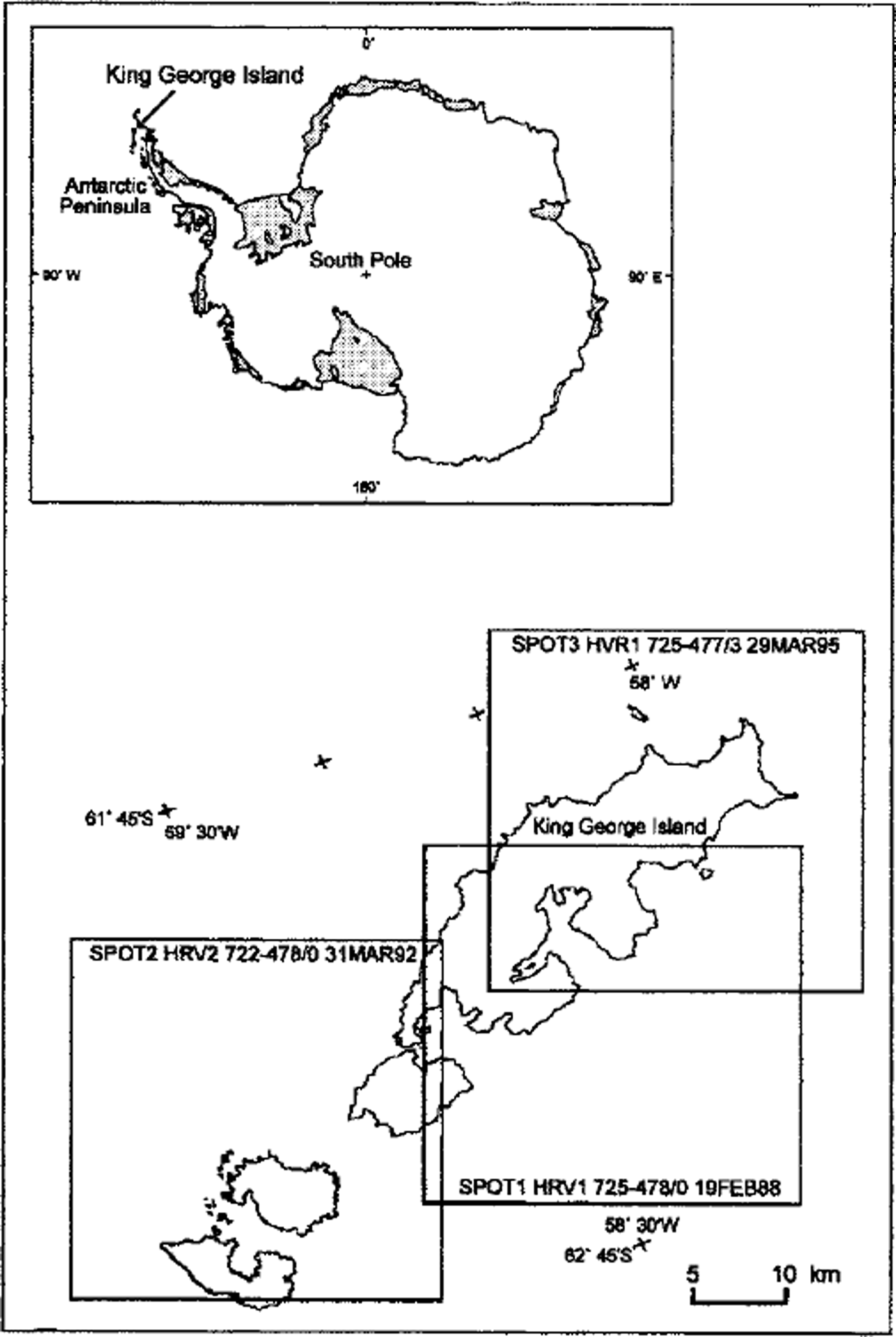
Fig. 1. Location of the three images (SPOT HRV) used in this work. Antarctic map shows the location of KGI.
Data Sources and Mosaicking
Complete coverage of KGI with SPOT HRV products required scenes obtained from three images (SPOT-1 HRV 725-478/0, 19 February 1988; SPOT-2 HRV 722-478/0, 31 March 1992; and SPOT-3 HRV 725-477/3, 29 March 1995) (Fig. 1), corrected geometrically before mosaicking. The map series BAS D501 (BAS, 1968), produced at a scale of 1:200 000 on the Lambert Orthomorphic Conic Projection, was used for this correction. These topographical maps were derived from an aerial photographic survey carried out by FIDS during the austral summer 1956-57 at a scale of 1:27 000. The hypsometric information on these maps is not reliable; the FIDS survey did not fully cover the interior of the ice field, and only general contours (at 200 m intervals) are shown. On the other hand, the island fringe information is considered correct. Maximum errors of 20 m are estimated for the traced ice-front positions, giving a greater accuracy than those from analysis of the SPOT image mosaic. Fifty-one ground-control points (GCPs) were used for rectification of the scenes, using a second-degree polynomial model with residuals to within four pixels (i.e. 80 m) for the correction. Resampling was done by the nearest-neighbour method, with a pixel size of 20 m for the entire mosaic. The final product at a 1:100 000 scale was then compared with the scanned BAS map (at a 300 dpi resolution). The resulting mosaic is shown in Figure 2.
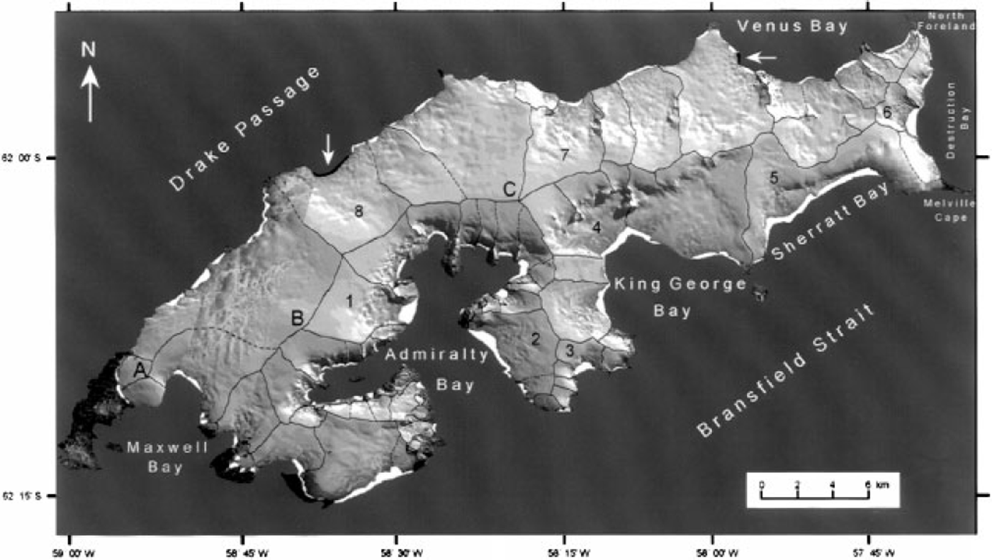
Fig. 2. Annotated SPOT HRV mosaic of KGI created from scenes of three images identified in Figure 1. These scenes were put together using band 3 (0.79-0.89 µm) and geometric correction was applied using the BAS (1968) maps (1:200 000, Lambert Orthomorphic Conic Projection). Drainage-basin divides are delineated by a curve (dashed if their positions were inferred). Numbers identify basins discussed in the text (1. Lange; 2 Vieville; 3 Wit Stwosz; 4. King George; 5. Hector; 6 Destruction Bay; 7 Eldred; 8 Usher). White areas on the coast have disappeared since 1956, black areas indicated by white arrows (e.g. drainage basin 8) have advanced since 1956 A false gray tone was applied for the sea area to increase contrast with the ice field. Notice clouds in the northern part of KGI, from Sherratt Bay to CaPe Melville and in the central part between domes A and B.
RES studies carried out by the Russian Academy of Sciences in 1970 (Reference Govorukha, Chudakov and ShalyginGovorukha and others, 1974) and 1995 (Reference Glazovskiy and MoskalevskyGlazovskiy and Moskalevsky, 1995), BAS (flight 38 in 1975; unpublished information, BAS RES data bank), a Sino-Uruguayan group in summer 1991-92 (personal communication from A. Lluberas, Uruguayan Antarctic Institute, 1992) and a Russian-Brazilian joint operation in 1995-96 (Reference Macheret, Moskalevsky, Simoes and LadouchMacheret and others, 1997) provide ice-thickness measurements at several points, giving a notion of bedrock morphology.
Major Findings: Glaciological Results
Ice-field surface morphology
A near-infrared (0.79-0.89 µm) SPOT mosaic (Fig. 2) delineates 70 drainage basins on the KGI ice field. The ice surface is strongly controlled by the bedrock topography in the southwest-northeast direction. Ice divides are well marked in this SPOT mosaic and in higher-frequency European Remote-sensing Satellite (ERS-1) synthetic aperture radar (Reference Simoes and BremerSimões and Bremer, 1995), reflecting very slow changes in slope that are not identified as any single break on the surface during field surveys. Surface undulations across the flow direction (wavelength about 1km) are observed over the greater part of the ice field, particularly in the ablation area. Reference Rees, Dowdeswell, Diament and KaldeichRees and others (1993) attributed this feature to interactions of changing snow facies and surface topography.
Three non-symmetric ice domes (A-C in Fig. 2) are connected to each other in the main direction of the island. A maximum elevation of 700 ± 10 m, determined by a pressure altimeter, is reached in Dome B. Ice draining northwestwards from the main divide flows 6-8 km to cliffs in Drake Passage; this part of the ice field tends to a quasi-parabolic shape. Flow to the southeastern coast is mainly by fast-moving, strongly convergent outlet glaciers with abrupt icefalls that drain the ice-field plateau (from about 550 ma.s.l.) into bays. Some of these outlet glaciers (e.g. Lange Glacier, drainage basin 1 in Fig. 2) occupy well-defined depressions, have marked flowlines (eg. King George, drainage basin 4 in Fig. 2) and are generally heavily crevassed. Drainage basins flowing into Drake Passage are controlled by bedrock blocks in the southeast-northwest direction in the southern and northwestern parts of this coast. In the central part, blocks have a quasi south-north direction (e.g. Eldred Glacier, drainage basin 7 in Fig. 2), and drainage basins are parallel to each other. Similarly, drainage basins flowing into Admiralty Bay or Brans-field Strait are strongly controlled by bedrock blocks in the southeast-northwest and south-north directions. Some glaciers, however, follow blocks in the east-west direction. Finally, drainage-basin delimitation was impaired in two sections due to cloud cover: (a) in the northern part of the island, from Sherratt Bay to Cape Melville, and (b) in the central scene between domes A and Bin Figure 2.
At present, the ice field covers 1158 km2 (92.7% of the total area of the island). Another 0.5 km2 of the island is covered by small cirque glaciers not contiguous to the ice field, mainly over the small peninsulas in Admiralty Bay and on the Bransfield coast. The longest basins, on the Drake Passage coast, reach 8.3 km in extent. Few nunataks pierce the ice field. The ice-free area (92 km2) is concentrated along the coast.
Drainage basin fluctuations
Comparison of the geocoded satellite mosaic (Fig. 2) with the digitized BAS map suggests ice-front retreat at 45 drainage basins during the period 1956-95. Six drainage basins (1. Lange; 2. Viéville; 3. Wit Stwosz; 4. King George; 5. Hector; 6. Destruction Bay) retreated 500 m or more. For example, Lange Glacier, a fast-flowing outlet glacier with a drainage basin of 30 km2 in Admiralty Bay, retreated about 1000 m, losing 2 km2 of its area. In total, the ice field has lost 89 km2 since 1956-57, a 7% reduction in the total ice-covered area, mainly in bays flowing into Admiralty Bay and to the Bransfield Strait.
An exception is Usher Glacier (drainage basin 8 in Fig. 2) on the northern coast, where the front advanced about 600 m in the same period. In fact, no substantial retreat is recorded for the glacier basins flowing into Drake Passage (north-northwest). Other glaciers may have oscillated at less than the estimated error limit for the method used (i.e. ±50 m).
Snow/ice facies and transient-snowline position
Examination of band 3 (0.79-0.89 µm) of the central SPOT image (SPOT-1 HRV 725-478/0,19 February 1988, Fig. 3) allowed the identification of a limit for two facies at the surface (groundwork carried out in the summers of 1993-94 and 1995-96):
-
(1) A facies characterized by a high surface reflectance that is tentatively attributed to a "snow facies" including the percolation and wet-snow (soaked) zones (following the terminology of Reference BensonBenson, 1962). Shallow cores taken by the authors at dome B indicate that the summit of the ice field is in the percolation zone.
-
(2) "Ice facies" including ablation and superimposed-ice zones. This area is characterized by a low reflectance lowered by a high dust content at the surface by the end of the ablation season (field observations in 1995).
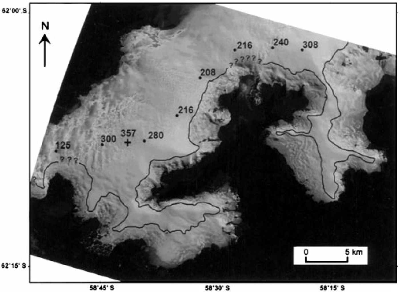
Fig. 3. The southeastern part of KGI at the end of the balance year (SPOT-1 HRV 725-478/0,19 February 1988). The location of this image is shown in Figure 1. A solid line at about 350 m a.s.l. indicates position of the transient snowline. No snowline is marked for the northern coast due to cloud cover, and interrogation marks indicate where the snowline was estimated. Spot ice-thickness soundings (in meters) were obtained from Reference Macheret, Moskalevsky, Simoes and LadouchMacheret and others (1997); a cross indicates the site of maximum thickness measured by the BAS in 1975 (flight 38).
The limit between the two facies was interpreted as the position of the transient snowline at the end of summer (at about 300-350 m a.s.l.). The snowline was observed at 400-450 ma.s.l. in summer 1994-95.
The northernmost image (SPOT-3 HRV 725-477/3) was taken after the late-summer snowfalls, so the snowline at the end of the ablation season could not be defined. Further, the snowline is not identical with the equilibrium-line altitude in a subpolar ice mass because there is an intermediate zone of superimposed ice between them.
Ice thickness and bed topography
Figure 3 shows some spot RES (in meters) derived from Reference Macheret, Moskalevsky, Simoes and LadouchMacheret and others’ (1997) RES survey. The thickest ice is found near the summit, over a graben parallel to a southwest-northeast subglacial ridge. Ice thickness increases sharply to the west, in the southern part of the ice field, before decreasing as it approaches the coast. A subglacial valley, with ice thickness frequently > 250m, parallels the subglacial ridge. A maximum ice thickness of 357 m, determined by a BAS survey (flight 38 in 1975; unpublished information, BAS), is reached about 4 km from the divide. Part of the surveyed area did not show bedrock echoes, which was to be expected considering that inhomogeneities (e.g. ice lenses associated with melting and refreezing) and a greater concentration of impurities (e.g. volcanic ash originating from eruptions) make ice more "lossy" to electromagnetic energy (Reference Dowdeswell, Drewry, Liestol and OrheimDowdeswell and others, 1984). Turbid meltwater plumes in front of several outlet glaciers and 10 m temperatures near 0°C (Reference Simoes and BremerSimões and Bremer, 1995) indicate that at least part of the ice field is at the pressure-melting point. Further details of RES results on KGI are found in Reference Macheret, Moskalevsky, Simoes and LadouchMacheret and others (1997) and Reference Macheret and MoskalevskyMacheret and Moskalevsky (1999).
Discussion
Marked structural control associated with the main fault direction is a dominant feature of the KGI ice cover. The ice plateau follows a southeast-northwest subglacial ridge identified by Reference BirkenmajerBirkenmajer (1983). To the north of this block, a northwesterly trough is filled by ice thicker than 300 m. Further RES soundings will be necessary to obtain an adequate idea of the subglacial topography.
It is tempting to associate the retreat of the outlet glaciers with the warming trend recorded for this region during the last 50 years. Similar changes have been observed elsewhere in the South Shetlands (e.g. on Livingston Island: Reference Calvet and CorberaCalvet and Corbera, 1993). Further, some of the most rapid changes in glacier morphology have occurred since 1995 in the northeastern part of the Antarctic Peninsula, such as the disintegration of the northern part of the Larsen Ice Shelf (Reference Rott, Skvarca and NaglerRott and others, 1996) about 300 km from KGI. Notwithstanding, it is well known that glacier response to climatic changes may lag by decades to centuries (Reference PatersonPaterson, 1994). Mass-budget studies carried out on dome A (Fig. 2) do not point to a negative mass balance (Reference Wen, Jiahong, Zichu, Jiankang and LluberasWen and others, 1994). Changes observed on KGI may be related to other factors, such as a reduction in sea-ice formation along the southern coast: the sea-ice season has become shorter and more irregular over the past few years. A reduced sea-ice cover may have allowed a higher frontcalving rate, particularly of outlet glaciers with floating snouts.
The different behavior of outlet glaciers flowing to the northern coast may have resulted from different accumulation regimes as cyclones coming from Drake Passage become moisture-depleted. New studies will be needed to determine the "anomalous" behaviour of the advancing Usher Glacier. Its ablation area is heavily crevassed, but no surge characteristics such as a looped moraine or down-draw of the upper basin are observed.
Conclusions
Ice morphology of the KGI ice field (1158 km2) is strongly controlled by the bedrock structure. Most of the 70 drainage basins flow through outlet glaciers mainly following bedrock blocks oriented southeast-northwest. A maximum ice thickness of 357 m is found 4 km from the summit at dome B.
The termini of 45 outlet glaciers retreated hundreds of meters to 1 km during the period 1956-95. At the end of the summer melting season (February-March) the transient snowline is found at about 300-350 m a.s.l., but it has been recorded at higher elevations for the last 4 years (up to 400-450ma.s.L). Similar changes have been observed for other ice fields in the South Shetlands and are probably a response to regional climatic warming, but further studies are needed to confirm this hypothesis.
Acknowledgements
This work was supported by the Brazilian Antarctic Programme (PROANTAR) through a grant toJ.C.S. from the Brazilian National Council for Scientific and Technological Development (CNPq). U.F.B, F.E.A. and F.A.F thank CNPq for studentships. We thank A.W. Setzer from the Brazilian National Institute for Space Research (INPE) and Yu.Ya. Macheret and M.Yu. Moskalevsky from the Institute of Geography, Russian Academy of Sciences, for providing data and for discussions on this paper. We thank the BAS for unpublished RES data.


