


Introduction
Study of the global distribution of humans, plants and animals can provide considerable information regarding the ecology of individual species and their biogeographic history, and informs expectations regarding future change (Harsch et al. Reference Harsch, Hulme, McGlone and Duncan2009). To date, evidence for the southernmost extent of pre-industrial human activity was known from Herschel, Wollaston and Bayly Islands (the area generally known as Yashkùshi), Chile (Legoupil Reference Legoupil1993). Here, we report on a new site, located 10km further south, on the highly exposed Isla Hornos (Isla Lököshpi), at the true southern tip of South America. We believe that this site represents the southernmost extent of pre-industrial human groups worldwide, given the lack of opportunities further south.
The site
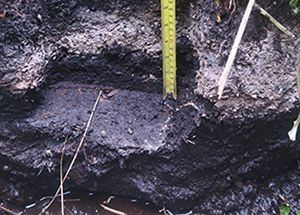
The site is located on the southern fringe of Isla Hornos, Chile (Figure 1). It is situated near the edge of a tussac grass (Poa flabellata) terrace, approximately 3m asl, above the wave-impacted zone (Figure 2). The area is cut through by penguin tracks and runs, which have exposed a side profile of the site. The remains of a hearth, consisting of substantial charcoal and ash layers, and a shell midden, are found approximately 0.12m below the soil surface (Figure 3A). Other evidence includes a multi-denticulate harpoon point (Figure 3B), another incomplete harpoon point, and a large quantity of animal bones from sea mammals and birds. The site is interpreted as an ancient hunting camp that was occupied for a short period of time, given its depth (there is no evidence for external burial of the site, such as, for example, through lateral soil movement), its small size, and the absence of exotic materials. There is no evidence of historic animal farming, wood extraction or other anthropogenic impacts on the archipelago, beyond Yaghan visits. These probably continued by boat into the early twentieth century, as recorded by oral histories such as that of Martin Gonzalez Calderon, which inspired these archaeological investigations.

Figure 1. The location of Isla Hornos in relation to South America and the local region (the Cape Horn archipelago), with Tierra del Fuego to the north. The arrow in the local map indicates the approximate location of the site (figure by B. Buma).
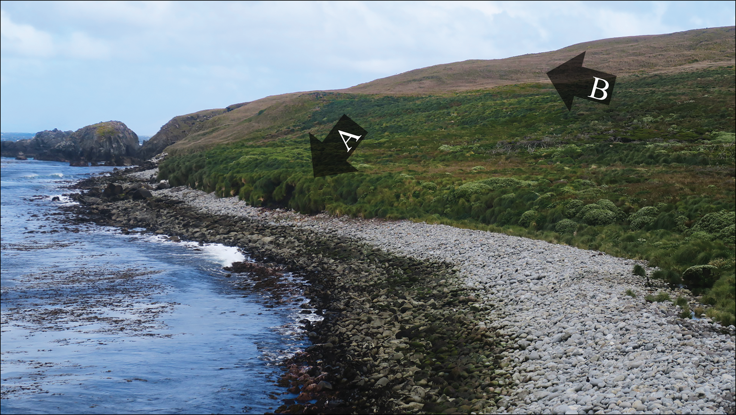
Figure 2. Location of the world's southernmost archaeological site (A) and southernmost individual tree (B) on the southern coastline of Isla Hornos (figure by B. Buma).

Figure 3. A) A layer of charcoal, burnt shells and ash exposed by penguin pathways; B) the most developed bone implement found at the site; C) the larger patches of trees on the island are dying back along exposed edges; D) in more sheltered locations, many trees are healthy (photographs by: A) F. Morello; B) M. Christensen; C & D) B. Buma).
Calibrated radiocarbon dates for two charcoal samples place the hearth and campsite between cal AD 1428 and 1803 (95% confidence, Beta-555655/555656; high probability density range method, SHCal database; Bronk Ramsey Reference Bronk Ramsey2009; Hogg et al. Reference Hogg2013), and suggest that activity possibly relates to more than one event. The Western geographical discovery of the southernmost islands of the American continent, including Cape Horn, dates to Francis Drake's 1578 voyage (Martinic Beros Reference Martinic Beros2005), although first contact with the Indigenous populations of the Cape Horn archipelago occurred later, in 1624, and further to the north (Martinic Beros Reference Martinic Beros2006). Thus, the uncertainty around the earliest dates for the site spans both before and shortly after initial contact. Yaghan peoples have inhabited the region for millennia (Orquera & Piana Reference Orquera and Piana2009); hence, we do not imply that the site represents the only or first visit by the Yaghan. Instead, it provides definitive evidence that pre-industrial human activity extended to this southern extreme at least on one occasion. Hence, we conclude that this site is currently the southernmost archaeological site created by pre-industrial groups.
The site's situation—similar to that of many other coastal prehistoric sites around the world (Hollesen et al. Reference Hollesen2018)—means that it is under considerable threat from climate change. Increases in storm frequency and intensity threaten erosional loss (Sampe & Xie Reference Sampe and Xie2007; Jones et al. Reference Jones, Harpham and Lister2016), as does ongoing penguin burrowing. Such factors should be taken into consideration when prioritising additional fieldwork in the area and elsewhere.
Finally, we note that the world's southernmost tree, a Nothofagus betuloides (Magellan's beech), was found on a north-east-facing slope on the island during our expedition (Figures 2 & 3C–D), placing it at the hypothesised global climatic limit for tree growth (Körner & Paulsen Reference Körner and Paulsen2004; Buma et al. Reference Buma, Holz, Diaz and Rozzi2021). These two finds—the worlds southernmost archaeological site and the southernmost trees—represent global signposts, both climatic and social, within a highly sensitive, extreme environment. Their co-occurrence only a few hundred metres apart points to the close relationship between people and ecosystems, and the site should be recognised as globally significant for both human and natural heritage.
Acknowledgements
Funding was provided by Fondo de Apoyo a la Investigación Patrimonial de la DIBAM -2016 (Chile), the National Geographic Society (NGS 147S-18), the Network for Extreme Environment Research (NEXER), Universidad de Magallanes, and Basal Funding CONICYT AFB17008, IEB Chile. Fieldwork was supported by John Harley, Omar Barroso, Kelli Moses, Ezio Firmani and the crew of the Oveja Negra, and Mr Andres Morales, the Alcalde de Mar of the Chilean Armada. Buma and Morello contributed equally to fieldwork and the writing of this article, and Rodriguez and Serrano Fillol to funding of the harpoon analysis and background sociological research.


