


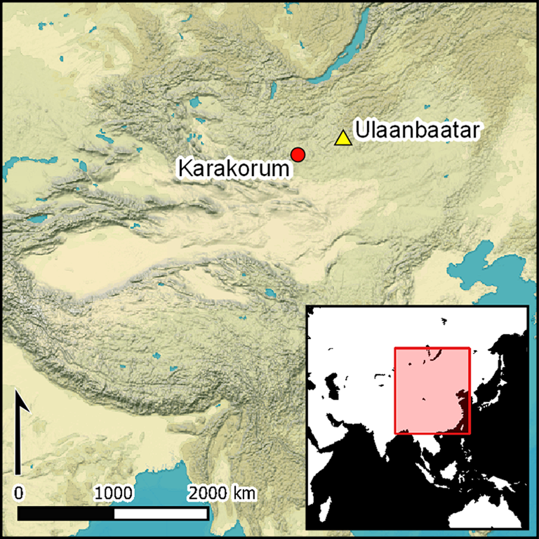
Introduction
The ancient Mongolian city of Karakorum was constructed after AD 1220, with a magnificent palace added in 1235 (Sagaster Reference Sagaster1999). An eyewitness account written in 1254 by Franciscan friar William of Rubruck, an envoy of King Louis IX of France, describes an enclosed city with four gates, which was home to Chinese artisans, Muslim merchants and captives from all over the empire (Jackson & Morgan Reference Jackson and Morgan1990: 212–20). Most historians and archaeologists have simply accepted these observations at face value, and no previous research has been undertaken to add detail to this picture by locating the different quarters, elite residences and other areas, or to understand how the city developed over its 200-year existence.
More generally, there has been a tendency to view the few cities in this steppe region, where there is no urbanisation and no continuous tradition of urbanism until c. AD 1500, as distinct from those of sedentary societies. The Eurocentric image of the city, however, is inappropriate, and concepts such as low-density, agrarian-based urbanism and ‘disembedded’ centres (Joffe Reference Joffe1998)—documented elsewhere in the world (Fletcher Reference Fletcher2020)—are of potential relevance. In order to understand how Karakorum might relate to these different framings of urbanism, a reliable idea of the extent, density and form of the city is an essential prerequisite.
The Mongolian Plateau on which Karakorum was built is often considered a purely pastoral nomadic ecozone, but is, in fact, rich in monuments, with permanent structures ranging from small settlements and walled enclosures to fortifications, monasteries, and large cities covering several square kilometres. In most cases, these sites have remained untouched since they were abandoned, being neither built over nor levelled by ploughing. The region therefore offers ideal conditions for remote sensing and the successful application of magnetic and topographic measurement techniques across extensive areas. Our project has deployed a range of these survey techniques at Karakorum, which, in combination with historical records, allows us to advance a revised account of the extent, the layout and the social organisation of the city through time. Here, we discuss the methods used and the results obtained, and demonstrate that the cities of the eastern Eurasian steppes were not fundamentally different from those of sedentary cultures, featuring many of the same attributes (Bemmann & Reichert Reference Bemmann and Reichert2020).
Historical background
In AD 1220, Chinggis Khan (r. 1206–1227) chose for the location for his camp a site where the canyon-like upper Orkhon River Valley transitions into the extensive pastures of the middle Orkhon Valley. On this same site, his son and successor, Ögödei (r. 1229–1241), established the city of Karakorum (Sagaster Reference Sagaster1999); the building programme was completed under the rule of Möngke Khan (r. 1251–1259). For both Ögödei and Möngke, Karakorum was part of the imperial itinerary (Atwood Reference Atwood2015). Twice a year, the khan would stay in the city for an extended period, and Ögödei encouraged the elite of the empire to build houses near his palace. In its heyday, Karakorum was the destination of numerous foreign legations and long-distance traders. Forcibly relocated craftspeople and prisoners of war laboured for the court and the military in the enclosed area of the city (Reichert Reference Reichert2020).
After the dissolution, in 1260, of the empire (Yeke Mongol Ulus) into the separate entities of the Yuan Empire, Ilkhanate, Chaghatayid Khanate and Golden Horde, Khubilai Khan (r. 1260–1294) developed Dadu—present-day Beijing—as the capital of the Yuan Empire. As one of the Ordu (camps of the ruling family) of Chinggis Khan, Karakorum retained a high ideological status and, after the foundation of Lingbei Province (1307), which roughly encompassed the territory of present-day Mongolia, the city remained the administrative centre of the region north of the Gobi Desert (Farquhar Reference Farquhar1990). In the first half of the fourteenth century, a series of public buildings were erected in the city, to which inscription stones bear witness (Matsuda & Ochir Reference Matsuda and Ochir2013). After the fall of the Yuan Empire (1368), Karakorum retained its importance for several decades as the seat of fugitive members of the Yuan Dynasty, probably falling into dereliction at the beginning of the fifteenth century (Reichert Reference Reichert2019). The Buddhist monastery, Erdene Zuu, was built in 1586 on the ruins of the walled palace area.
Although Karakorum was never forgotten due to frequent references to the city in European, Persian and Chinese written sources, its exact location was lost and only rediscovered by Nikolaĭ Yadrintsev in 1889 (Yadrintsev Reference Yadrintsev1889). A subsequent Orkhon expedition in 1891, led by Wilhelm Radloff, produced the first map of Karakorum (Radloff Reference Radloff1892: pl. 36). Despite the sketch-like nature of the plan, which was drawn in just a few days, the considerable extent of the city and variations in building density are clearly visible (Figure 1). All subsequent teams who have worked in the city over the last century—Russian, Mongolian, Japanese and German—limited their mapping efforts to the walled area and the buildings in front of the east gate (cf. Pohl Reference Pohl, Bemmann, Parzinger, Pohl and Tseveendorzh2009), yet the Radloff map, aerial photographs from the 1970s and modern satellite images clearly show that the settlement extended far beyond the walled area of the city. Furthermore, later reconnaissance of the site demonstrates that the resolution of a field survey in the 2000s was insufficient to detect features such as small roads or the embanked boundaries of ‘compounds’ enclosing one or more building platforms (Franken Reference Franken2015: 42 & fig. 12).
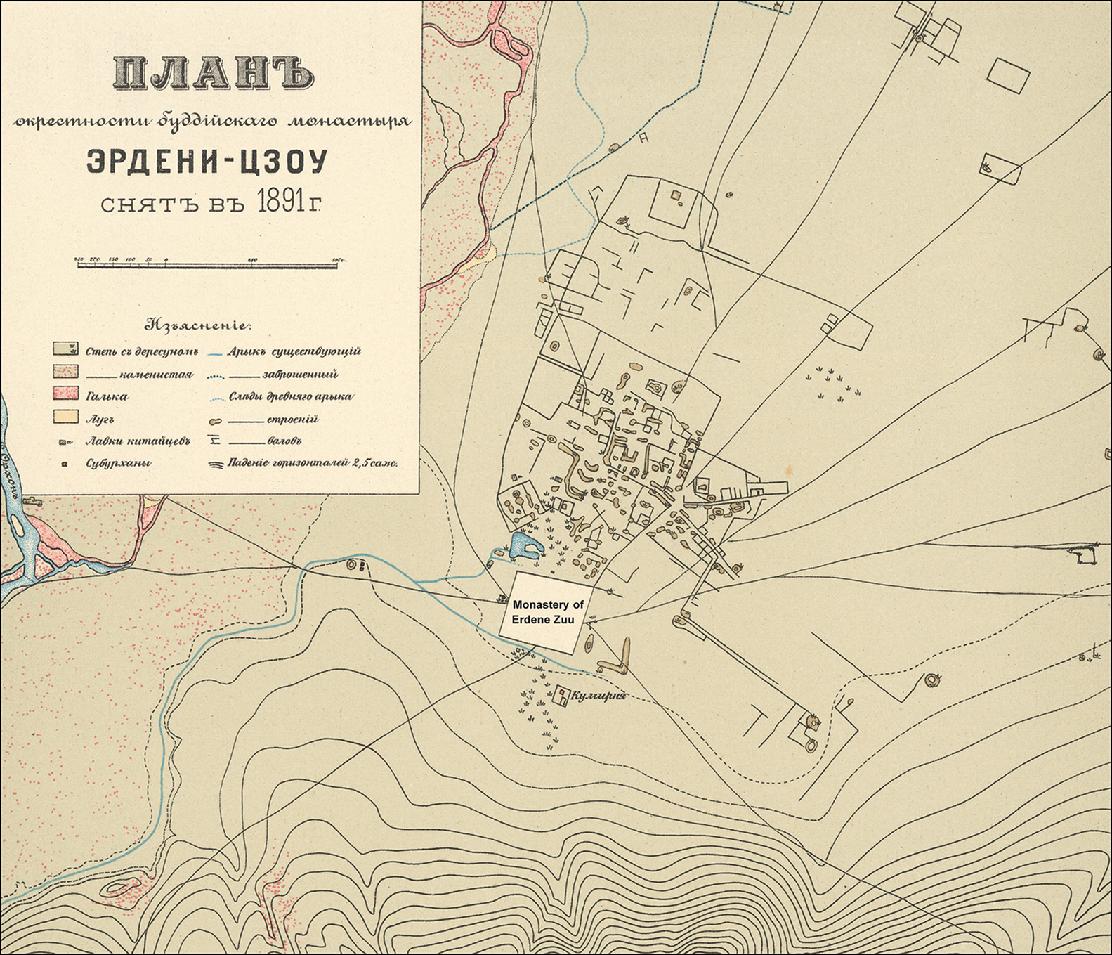
Figure 1. The first map of Karakorum, drawn by the Orkhon Expedition in 1891, depicting the modern monastery Erdene Zuu, with the body of the city to the north (modified by A. Stefanischin, after Radloff Reference Radloff1892: pl. 36).
Objectives
Our fieldwork sought to generate high-resolution mapping data covering both the area within the city walls and the extended settlement beyond. We specifically aimed to establish:
a) the size and extent of activity beyond the city walls;
b) the occupation density and thickness of settlement layers;
c) the location of particular neighbourhoods and areas of activity, including the distribution of pyrotechnical installations; and
d) access routes to the city and street layouts.
We also sought to establish a basis for planning for the further exploration and effective protection of the city, which has been a designated UNESCO World Heritage Site since 2004.
Methods
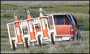
Our previous projects in Mongolia had demonstrated the efficacy of combining topographic and magnetic surveying, and we applied this methodology to Karakorum (Bemmann et al. Reference Bemmann2014). Extended geophysical investigations were carried out using a motorised measurement instrument that allows the simultaneous recording of magnetic and topographic data at high resolution and speed. The device was developed by the Leibniz IPHT and Supracon AG in Jena, Germany (Linzen et al. Reference Linzen2007). It combines the very high magnetic field gradient resolution of a SQUID-based (Superconducting Quantum Interference Device) sensor array with the precision of a differential GPS, supported by an inertial unit. The SQUID instrument was applied to an area of more than 465ha over 52 days in two campaigns in 2016 and 2017. A total distance of 3500 measurement-line kilometres was driven with an off-road vehicle pulling the cart (Figure 2). The SQUID system proved highly reliable.

Figure 2. The SQUID measuring system in operation at Karakorum (photograph by J. Bemmann).
The battery-driven data acquisition module on the cart records the magnetic data from each of the 18 SQUID sensors at a sampling frequency of 1000Hz. Further, the differential GPS data from a Trimble® 5700 receiver was recorded at 10Hz, and the Euler angles representing the tilt of the measurement cart, which is monitored by a Xsens® inertial unit, were sampled at 100Hz. These data streams resulted in a very high measurement point density of approximately 400 per m2 for the magnetic data and about 4GB per day of raw data (for further details, see Linzen et al. Reference Linzen2007). Vertical position error was limited to a few centimetres, allowing the detection of tiny altitude variations that were caused predominantly by archaeological remains. The current eroded condition of the site, however, limits the detectability of topographic features such as streets, or different types of buildings and urban districts. The analysis of the magnetic data provides essential information to address these lacunae. In this way, the magnetic signatures and topography of Karakorum have been documented as highly precise geo-referenced maps.
The complex setup of the SQUID sensors further enables the calculation of object depths and the modelling of 3D shapes (Schneider et al. Reference Schneider2014), but due to the high density of magnetic signatures—especially within the city centre—thousands of individual features need to be calculated and classified.
Complementary to the magnetic and topographic mapping, we conducted an intensive, systematic pedestrian survey in the areas surrounding the walled city. We abstained from a full survey within the walled city area (which would have enabled us to match surface finds with measured magnetic anomalies and built structures), as many generations of tourists, archaeologists and local antique dealers have altered the surface distributions significantly. Nonetheless, systematic collection of metal waste prior to the magnetic survey enabled us to form a subjective picture of the distribution of finds across the city and to identify zones more or less devoid of artefacts.
One goal of the survey was to improve understanding of the activities around the city and to delimit the city's full extent—that is, to undertake a ‘structural survey’ (see Banning Reference Banning2002). We therefore aimed for contiguous survey areas and full coverage (Fish & Kowalewski Reference Fish and Kowalewski1990). Two survey teams covered and documented an area of 62km2 adjacent to Karakorum and along the foot of the chain of hills to the east of the city (see Figure 3). Remains from all periods encountered were recorded, including monuments and artefact scatters. A minimum presence of three ceramic sherds within a 2m radius was used to identify a ‘site’. Survey crews were particularly alert to the potential for recognising ‘off-site’ activities, such as production sites and quarries. For better comparability and easier organisation, we opted for survey units of 1 × 1km, in which surveyors walked at 20m intervals, so sites smaller than 20m may have gone undetected. As similar procedures had been applied successfully in other regions of Mongolia (e.g. Wright Reference Wright2006), we purposefully orientated our methods to match these other projects to facilitate the comparability of results.
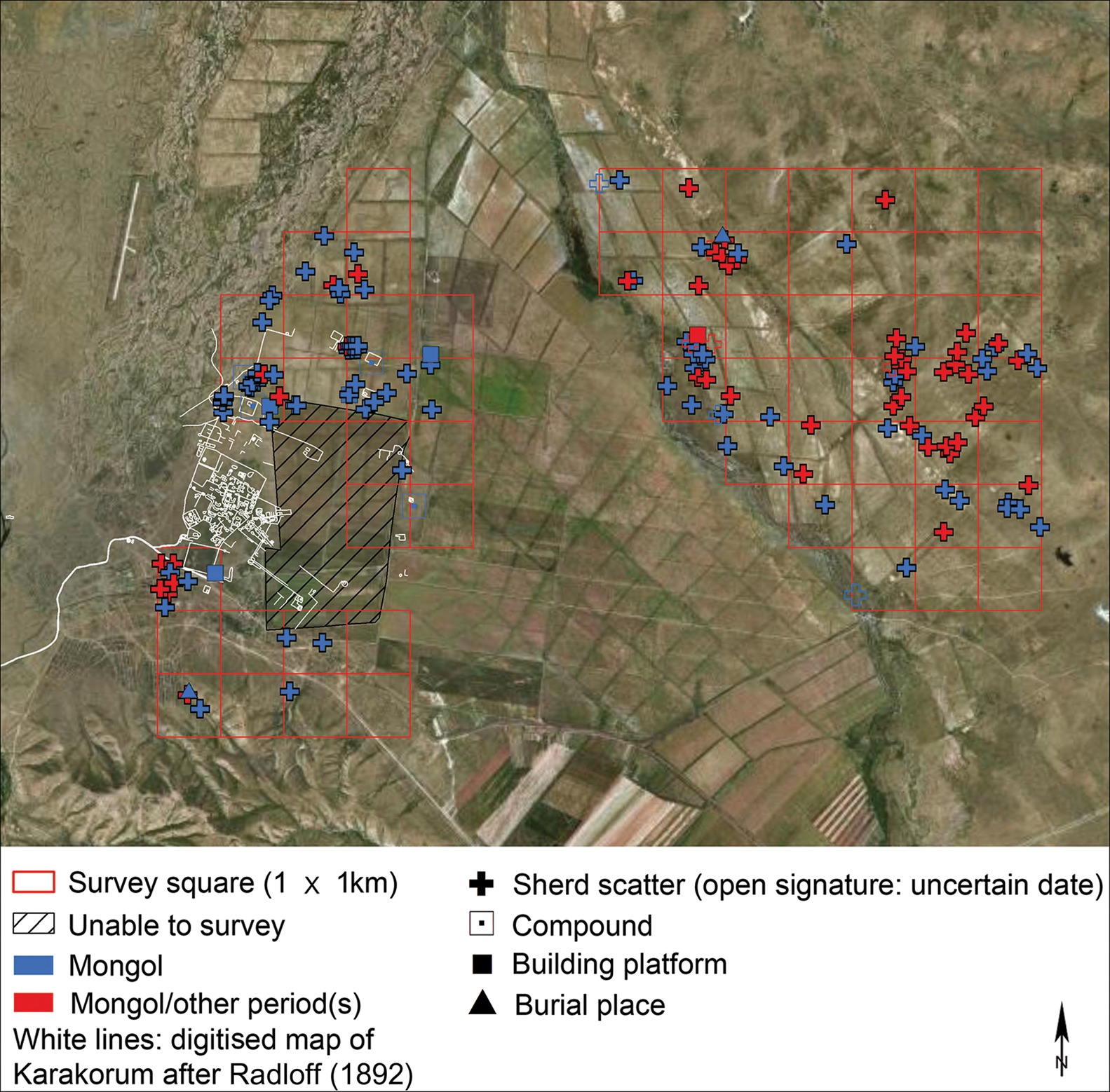
Figure 3. Distribution of Mongol-period sites documented during the 2016–2017 survey, with walls and buildings digitised from Radloff's (1892) map. The 1km2 squares serve as scale (background image © Esri, DigitalGlobe, GeoEye, Earthstar Geographics, CNES/Airbus DS, USDA, USGS, AeroGRID, IGN and the GIS User Community; graphic by S. Reichert).
Despite intensive efforts and support from the mayor of Kharkhorin sum, we were not permitted access to the extensive grounds of the agricultural cooperative in the eastern part of the ancient city (Figure 3). In addition, a high proportion of the area intended for survey was used for agriculture and some fields had been freshly sown. Hence, while access was granted for some areas, others had to be omitted.
Results and analysis
Detailed analysis of the new data provides a series of novel insights, the most important of which are introduced here.
Size
The new map (Figure 4) confirms our initial hypothesis that the city stretched far beyond the areas documented since the 1930s. In this respect, Radloff's early map remained the most accurate, until now, and was thus a remarkable achievement. Due to time and access constraints, we were unable to ascertain fully the northern, eastern and south-eastern extent of the settlement. The inundation area of the Orkhon River sets a natural limit in the north-west and west. The area south of the monastery of Erdene Zuu, which was surveyed by the pedestrian crew, appears to be void of structures built during the time of the Mongol Empire. The survey did not yield any sites except for sherd scatters, which is unsurprising given the close proximity of the city. Satellite imagery, however, confirms that some of the features mapped by Radloff in 1891 remain visible today (Figure 4). We were able to identify single platforms shown by Radloff, but heavy ploughing activities have destroyed and flattened features once visible above ground. Taking these observations together, we were unable to estimate how densely these areas had been settled and when the occupation declined. The distribution of sites suggests intensive use of the surrounding areas during the Mongol era. This distribution extended as far as the eastern foothills—approximately 7–8km as the crow flies from the eastern gate—and demonstrates an absence of clear city boundaries (Figure 3). We documented 259 sites that cover several periods, 222 of which are artefact scatters and 61.3 per cent of which date to the Mongol period.
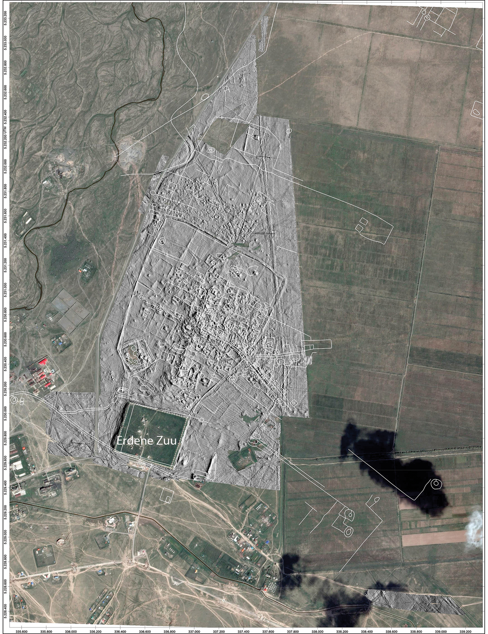
Figure 4. Combination of the new topographic map (grey shading), Radloff's (1892) map (white lines) and present-day aerial image. The new topographic map is based on high-resolution altitude data gathered with the SQUID system, alongside the magnetic measurements. The outlines of walls and buildings have been digitised from Radloff's map. The topographic map and aerial image are georeferenced precisely, Radloff's map approximately (aerial image © Esri, DigitalGlobe, GeoEye, Earthstar Geographics, CNES/Airbus DS, USDA, USGS, AeroGRID, IGN, and the GIS User Community; graphic by S. Linzen).
Excavations between 1978 and 1980 identified a Muslim cemetery adjoining the northern outer wall of the city (Bayar & Voitov Reference Bayar, Voitov, Bemmann, Erdenebat and Pohl2010). This 0.3km2 area was surrounded by compounds featuring inner platforms similar to those inside the walls, which were probably residential areas and not part of the cemetery. By breaking the city into its component parts based on the volume of settlement layers and building characteristics—which seemed to be correlated—we obtained a differentiated picture of its spatial configuration (cf. Table 1 and Figure 5). The palimpsest of the remains of 200 years of occupation, however, hindered interpretation. Further excavations are needed to determine the temporal scale and trajectories of the use of the different parts of Karakorum.
Table 1. Proposal for differentiating the built-up areas of Karakorum. The extent of the city outside the walled area is highly speculative and is estimated based on the area of built structures (cf. Figure 5).

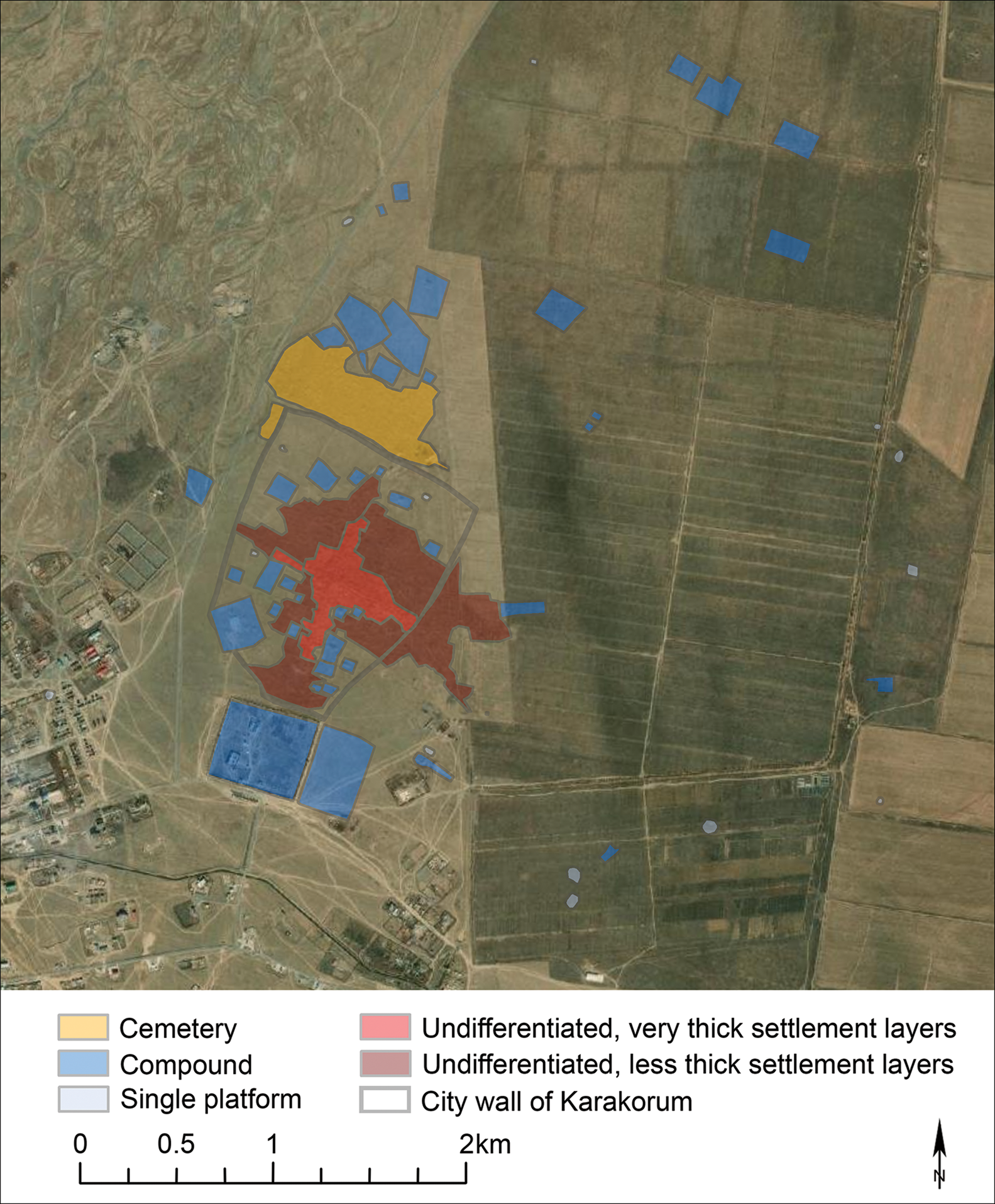
Figure 5. A first approach at differentiating the built environment of Karakorum (background image © Esri, DigitalGlobe, GeoEye, Earthstar Geographics, CNES/Airbus DS, USDA, USGS, AeroGRID, IGN and the GIS User Community; graphic by S. Reichert).
The walled area of Karakorum comprised 1.33km2, only 60 per cent of which was built up. Areas within the northern part were notably devoid of definite buildings, being characterised by low walls that did not form typically rectangular ramparts. These areas were also conspicuously poor in surface finds, and the surface was covered with Orkhon gravel, rather than a cultural layer that was present (to varying degrees) in the built-up area. In this case, we have no grounds to suspect the area to be less well preserved. We would argue instead that these areas were not used as permanent campsites, although temporary occupation cannot be excluded.
The central parts of the city were distinguished by large volumes of settlement layers. These account for 13 per cent of the walled area, and are covered with a different type of vegetation, namely Achnatherum splendens (Trin.) Nevski. This grass favours loamy soils and therefore functions as an indicator of underlying brick-built structures. These thick layers were surrounded by areas of lower settlement volume, indicated by layers that were comparatively less thick. Both areas were difficult to subdivide into distinct building features. Some compounds containing distinct buildings partly overlay these otherwise undifferentiated areas, but were mostly confined to the southern area, between the thicker settlement layers and the monastery.
We delimited the external settlement area by outlining all built structures beyond the city wall. This area extended over 11.8km2 and was much less densely built-up than the walled area (at about 11 per cent). If burial areas are subtracted, this decreases to approximately 8 per cent. These empty areas may have been used for temporary camps during social gatherings, such as quriltais (assemblies of the ruling elite).
Density and thickness of settlement layers
In the northern parts of the walled area, the ground surface is characterised by Orkhon River gravel. Excavations showed that buildings were not set into the ground, but rather, were erected on the alluvial fan of the river. These observations allow us to level the absolute value and the long-wave slope of the topographic measurement data to zero and then calculate the volume of the raised, anthropogenic structures. The levelling of the topographic data was carried out by means of a set of nodes sampled at the minima of the whole measured terrain. The sampling raster, however, was not equidistant due to regions of high building density (such as the city centre) that prevented meaningful sampling. From the set of nodes, a terrain model of the fluvial gravel was gridded using the Kriging algorithm. Finally, the absolute topographic map was reduced by the calculated model. The resulting levelled map (Figure 6) sharpens the focus on the hidden building remains and the design of Karakorum.
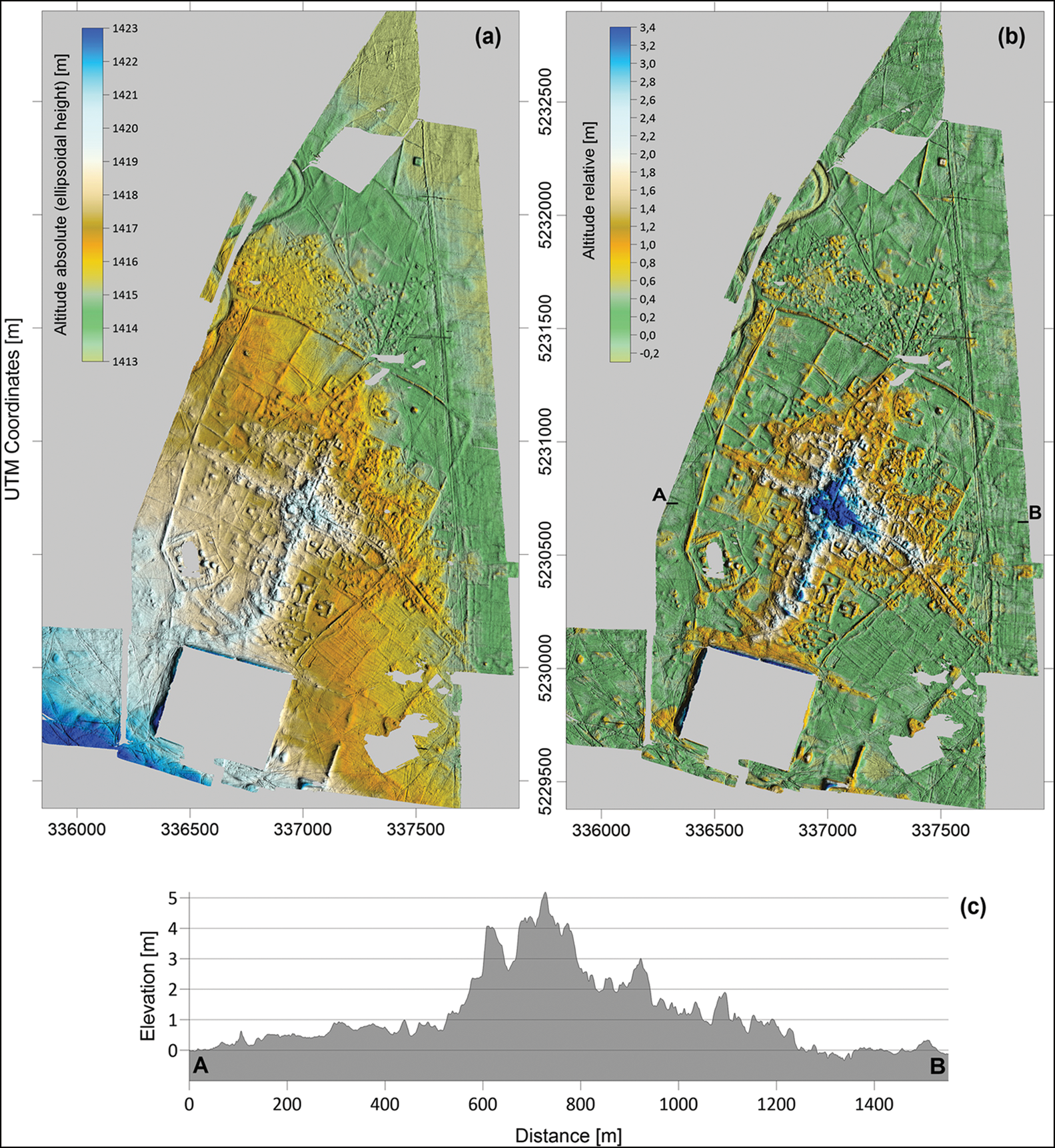
Figure 6. The new topographic map as (a) absolute and (b) relative altitude representation, with (c) section through the most elevated areas, all based on measured data gathered alongside the magnetic prospection. For (b–c), the modelled, natural terrain slope was subtracted (graphic by S. Linzen).
Using this calculation, we find the largest volume of settlement layers lay within the geographical centre of the walled city area, confirming the findings of the early twenty-first-century excavations. Here, the rate of building renewal, combined with the levelling of previous buildings and the concurrent accumulation of settlement layers, was particularly high (see Reichert Reference Reichert2019). In contrast, the areas extending concentrically outwards from the centre demonstrate much less volume, as attested by less accumulated cultural material.
There are several variables responsible for the accumulation of the settlement layers, including time (duration of use, seasonality), practices of waste disposal (on-site, off-site), building techniques (differences in material, quality), intensity of use and practices of caretaking (or lack thereof). As we are unable to control for all of these variables in the unexcavated areas, we cannot use accumulated settlement volume as a proxy for duration of occupation.
Neighbourhoods and ground plans
The detailed new measurements reveal, for the first time, distinct zoning within the city, allowing different functions and construction principles to be identified. In the south and west, compounds of various sizes dominate. Only firmly identified structures are highlighted in Figure 7, due to the possible presence of extensions, conversions and superstructures. The compounds appear to form a crescent around the area of thicker settlement layers. On the ground surface, they often feature coloured, glazed roof tiles and granite column bases, presumably representing the remains of buildings designed for elite members of the empire, and for administration and ritual activities. Using the 1891 map and the results of the 2019 survey, further compounds were identified to the north and east of the city wall. U-shaped and square, concave forms predominate in the northern quarter and along the eastern road, both inside and outside the city wall (Figure 8c). Within the wall, these buildings are delimited to the north-east by a low rampart that terminates some distance before the main street (Pohl Reference Pohl, Bemmann, Parzinger, Pohl and Tseveendorzh2009: 531 & fig. 23). The area to the north of this also includes compounds, but is less densely built-up. Along the west road, a few very large, almost square, concave forms can be seen. These probably represent walls of sun-dried mud bricks that have collapsed, creating debris outside the buildings and enclosing the concave forms now visible. On the road running north-northeast to south-southwest, only limited evidence of concave forms can be reliably identified, but much remains unknown due to the thickness of the layers and the backfilled excavation areas.
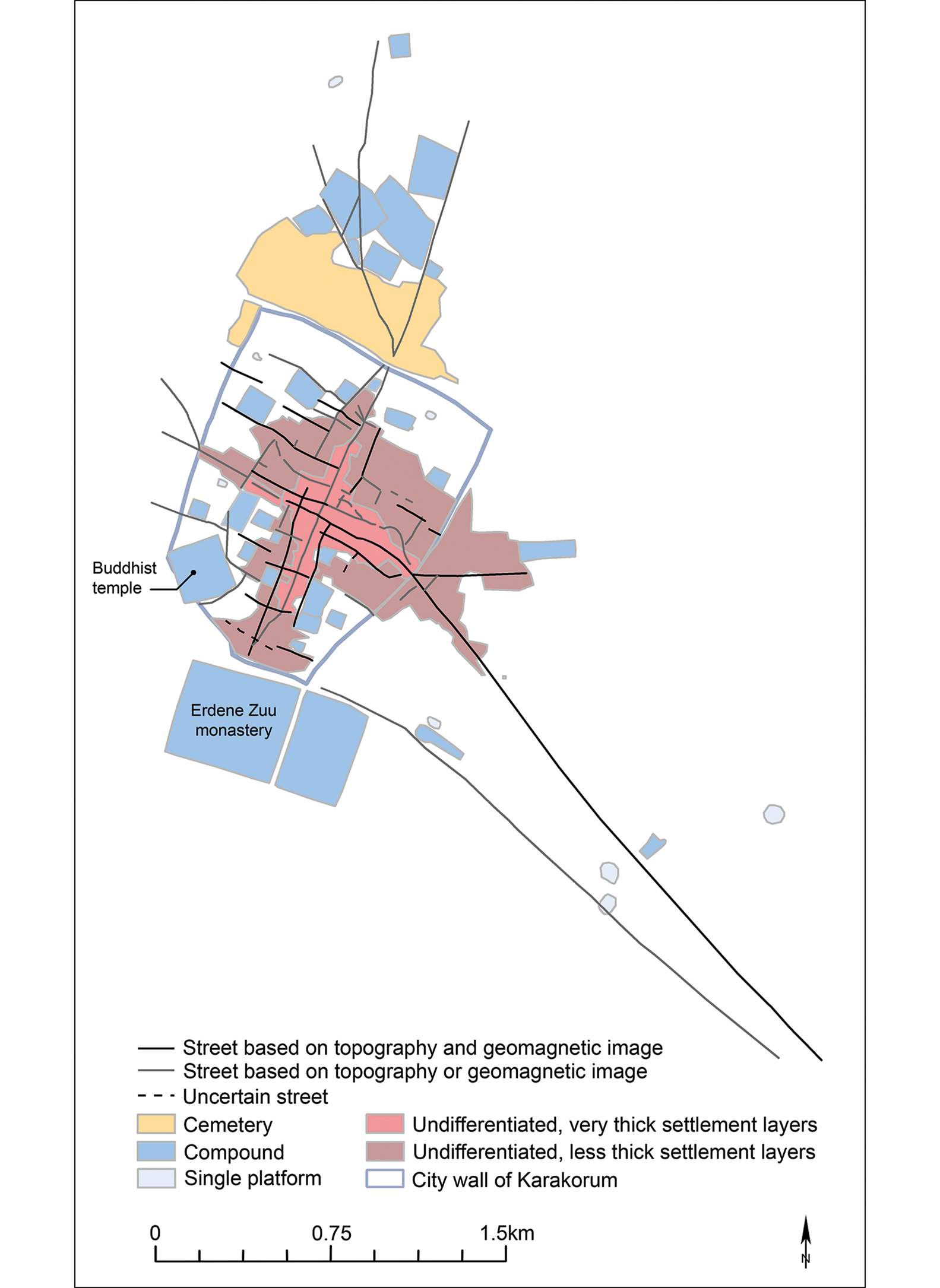
Figure 7. Preliminary reconstruction of the road system within and leading to Karakorum, based on the magnetic and topographic mapping (graphic by J. Bemmann and S. Reichert).
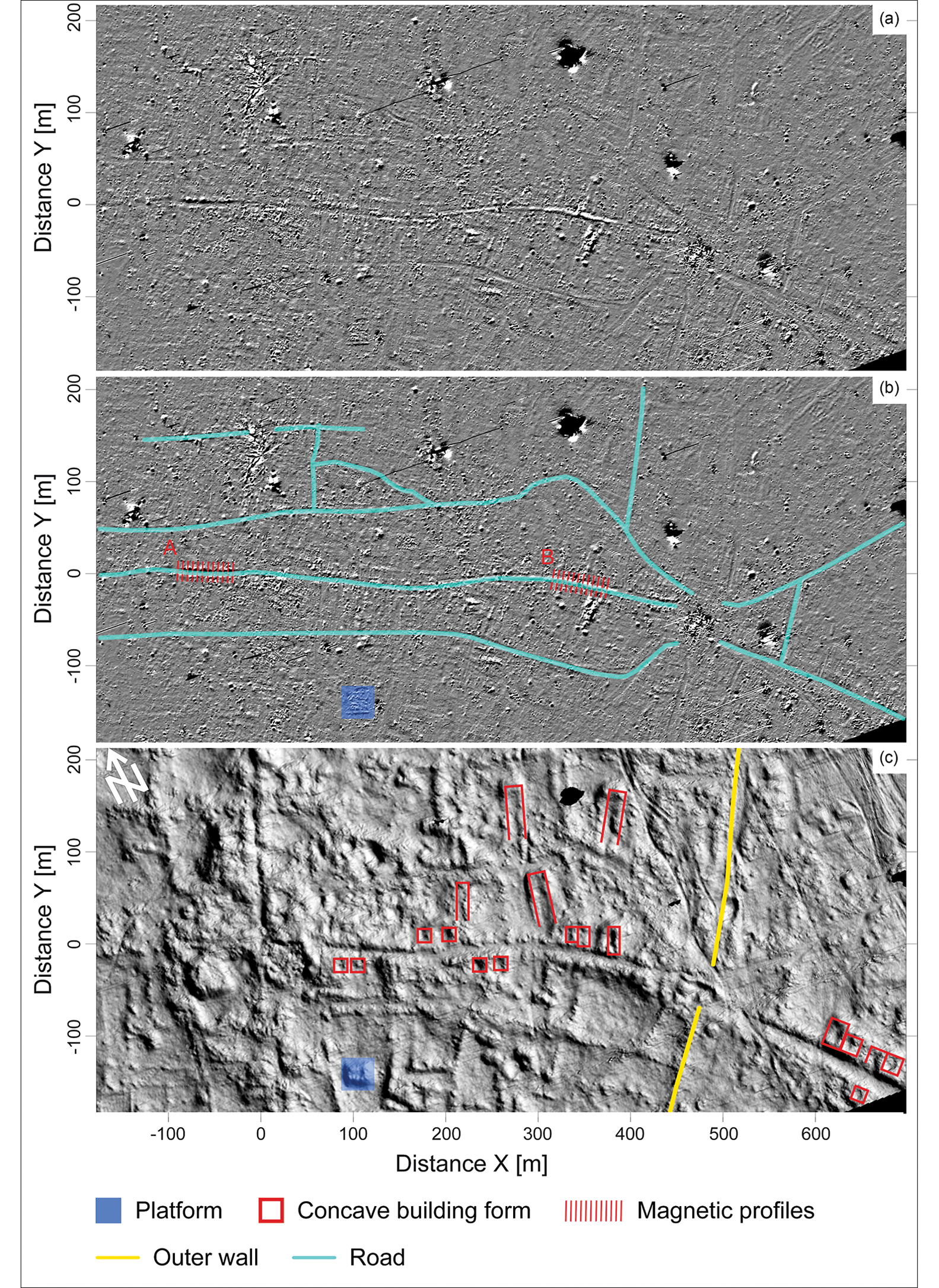
Figure 8. Section of the main road from the city centre to the east, passing the east gate: a) magnetogram; b) magnetogram with main roads; section A and B refer to Figure 9; c) topographic relief. For (a) and (b), data from one SQUID gradiometer set were used, which highlighted deeply lying, west–east oriented structures. The grey levels represent a range of ±15nT/m. Note the deviation of the map orientation by 27 degrees from north (graphic by S. Linzen, S. Reichert and J. Bemmann).
Access routes to the city and streets
In 1254, William of Rubruck noted that the enclosed city had four gates, outside each of which regional goods—especially livestock—were traded (Jackson & Morgan Reference Jackson and Morgan1990: 221). The densely built-up area outside the east gate and the two streets leading to it, which were identified by Radloff (Reference Radloff1892) and Kato (Reference Kato1997), indicate this to be the most frequently used point of access (Figure 7). By combining Radloff's map with modern satellite images and our own measurements, we are able to trace the road leading from the east gate for approximately 3km; both sides were lined by buildings, over long stretches. A second road leading from the east gate heads east-northeast and can be traced in the satellite image to a loop of the Khögshiin Orkhon River, although doubts remain about its exact course due to interference by modern agriculture and the lack of survey opportunities. An unexpected finding was a second road to the east—a section of which had previously been mapped by Radloff—that passed through the city wall at the north-east corner of the palace (today the monastery), and which possibly served the palace district. The two eastern access roads merge to the south-east of the modern agrarian cooperative and head towards China.
Two paths also leave the northern gate. One of these, which is partly disturbed by the modern cemetery, leads to the north-west, where it forks. Its western branch ends at an ancient Orkhon River loop. The other branch heads almost directly north, bisecting the Muslim cemetery and passing a large compound featuring a high, substantial platform to the east, before disappearing in modern farmland. This road probably led to Ogii Nuur, a lake approximately 60km to the north (as does the modern tarmac road), where it joined a well-known west–east route mentioned in contemporaneous documentary sources (Bretschneider Reference Bretschneider1967: 54–55).
Two paths lead from the west gate and terminate at an ancient tributary of the Orkhon; there was possibly a ford here. Since no constructions for water supply have yet been discovered in the city, water from the river was probably transported into Karakorum on carts, in storage vessels or leather bags.
A southern access point to the city has not yet been identified. It is likely that a path at the south-west corner of the enclosed Buddhist temple district ran along the southern wall of the complex. Since the western rampart did not reach the north-west corner of the modern monastery, the topography of the city, as seen today, suggests a wide entrance but, unlike with the other three gates, there is no path leading from this putative entrance into the city. Another possibility is that the southern entrance to the palace area was considered to be the southern gate. Juvaini (1226–1283), a Persian historiographer, reported that the palace area had four gates: “one for the passage of the World-Ruling Emperor, another for his children and kinsmen, another again for the princesses, and a fourth for the entrance and egress of the populace” (Boyle Reference Boyle1958: 236). This would have excluded public access to the city through the palace complex. A further possibility is that the southern part of the city wall may have run to the north of the lake surveyed by Radloff, terminating at the north-east corner of the modern monastery wall. This is supported by the fact that a strip to the north of the Erdene Zuu monastery remained undeveloped, and paths from the west, north and east join at this point. The fork in the southern road is 118m north of the Erdene Zuu monastery wall, so the southern gate may have been in this location. Furthermore, it is possible that the artificial pond (Figure 1) destroyed the older wall and the gate. If, however, the access road continued into the city, only this final option makes sense.
Inside the gates, the paths forked again. In contrast to previous research, which noted only a single, large road junction (Kiselev Reference Kiselev1965), bundles of paths can now be seen, especially in the magnetic survey (Figure 8). Five intersections can be identified along the north-northeast to south-southwest main road, with roads crossing from west-northwest to east-southeast. Only a small section of the southern road has been investigated, and was found to be 5.6m wide and paved with slate slabs. The courses of the roads from the city centre leading to the west and south are less defined and comprise fewer streets, which further underlines the importance of access to the city from the east and north (see Figure 7).
Close examination of the magnetic representations from two segments of the main road—Sections A and B—between the east gate and the city centre reveals significant differences in the signal magnitudes and behaviours (Figure 9; locations shown in Figure 8b). In many cases, the road courses are defined by strong magnetic signatures that flank the road on both sides (Figures 8b and 9: Section A). These signals may arise from the construction of road edges or kerbs, or from the walls of buildings. High gradiometer signal magnitudes of up to 80nT/m indicate the use of fired bricks in construction. By contrast, only small magnitudes are detectable along the road surfaces. Sedimentary stone pavements—especially at a depth of several metres—may not produce strong magnetic signatures, although such signatures can be found approximately 400m to the east (Figures 8b and 9: Section B). Within the first 30m of Section B, high magnitudes occur within the middle of the road, suggesting that a different paving material or road filling was used here, even though the thinner sediment coverage compared with Section A (closer to the city centre) generally produces stronger signatures. Analysis of the surrounding building signatures provides a possible explanation. South of the road in Section B, an impressive complex can be identified within the wide-amplitude scaled magnetogram (Figure 10c). This probably represents a craft area with technical constructions, such as small ovens, used for metalworking. The stronger magnetic signals within the road area of Section B may have been caused by material debris from these activities.
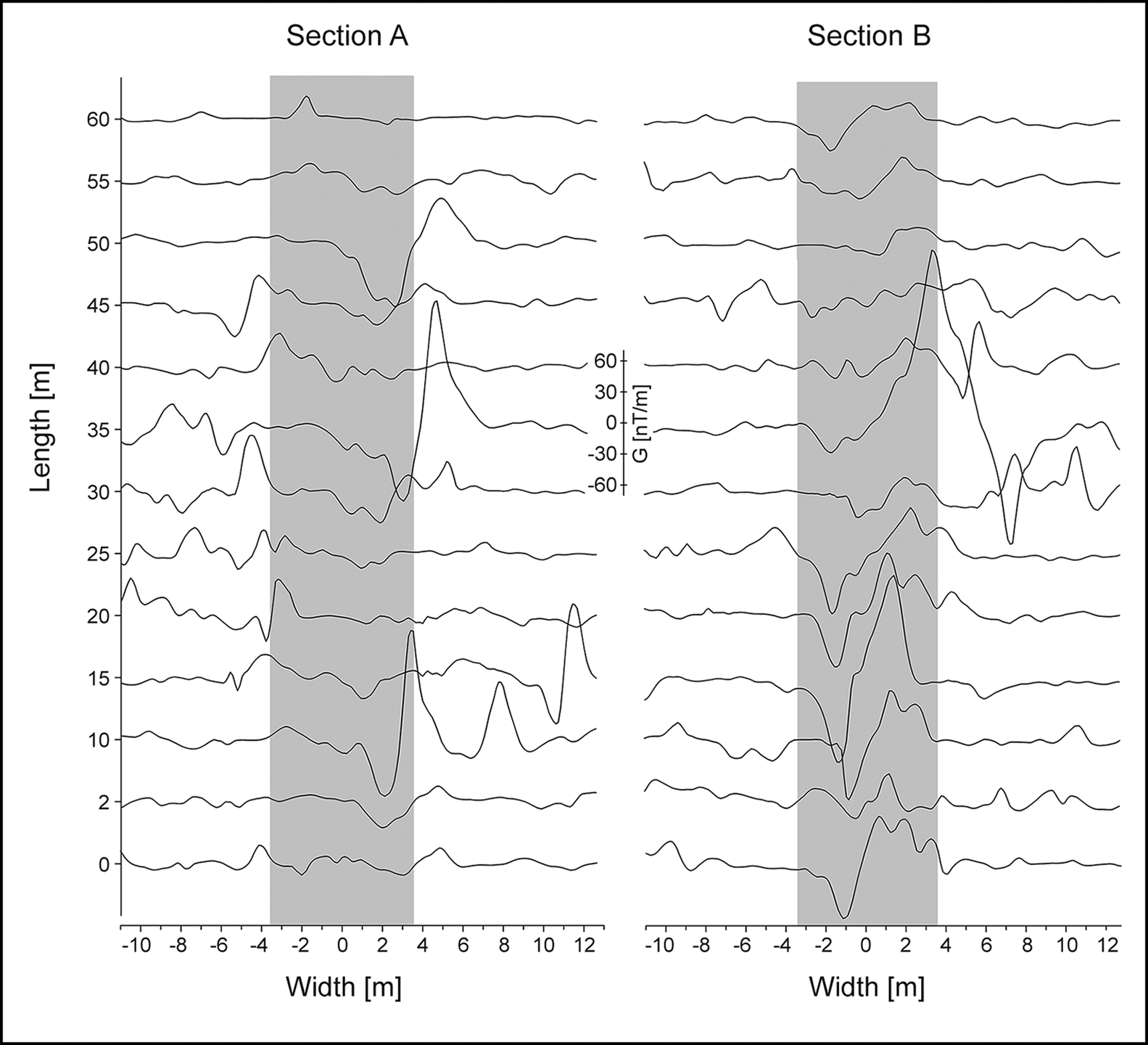
Figure 9. Representation of the magnetic signals from two segments of the main road between the city centre and the main east gate (for positions, see Figure 8b). Each segment covers 60m and includes 13 profiles (each 24m wide) captured every 5m perpendicular to the magnetic signature of the road. Grey areas show the approximate width and position of the road (graphic by S. Linzen).

Figure 10. a) Magnetogram of an enlarged section of Figure 8, with three different amplitude scalings; b) the three rectangles mark foundations and debris of buildings (i.e. fired bricks or natural stone with high magnetic susceptibility, mostly granite blocks (the blue rectangle denotes platform of Figure 8c)); c) areas marked in red represent very strong magnetic signatures (i.e. iron or highly fired objects) (graphic by S. Linzen).
Discussion
The compilation of well-known cities and walled enclosures in Central Mongolia reveals the comparative richness of the built environment within the Mongolian steppe zone and demonstrates Karakorum's place in the tradition of steppe urbanism (Table 2). The varying sizes of these sites alone points to different expressions of permanent settlements and thus their different requirements. The rather simple ramparts of the Xiongnu period (second century BC to second century AD), which mostly lack clear interior development, were a first step. While military domination in the form of garrison towns was the focus for the Kitan and Manchu rulers, the Uyghurs and Mongols had greater aspirations for their cities, which served as administrative centres and, when the rulers were present, as political centres.
Table 2. The size of Karakorum compared with approximate sizes of well-known cities and walled enclosures in Central Mongolia.

For a city like Karakorum, concepts of low-density, agrarian-based urbanism and ‘imperial cities’ can be used profitably, but they describe only one aspect and do not get to the heart of the matter. The peculiarity of these cities lies in the fact that they were ‘implanted’ by the ruler into a landscape without fixed architecture, and that the permanent inhabitants were brought from abroad. Hence, these cities remained foreign entities, the continued existence of which was unimportant for the pastoral nomads, as they were not dependent on them. Our current understanding suggests that the city of Karakorum and its inhabitants arrived fully formed. We therefore introduce the term ‘implanted city’ for this special case. While both ‘implanted city’ and ‘disembedded capital’ describe cities founded de novo, the latter is especially “designed to supplant existing patterns of authority and administration” (Joffe Reference Joffe1998: 549). In contrast, the Mongolian case is characterised by the fact that there were no pre-existing cities that the Mongol rulers could fall back on; ‘implanted cities’ were detached from the local pastoralist society and economy.
Conclusions
In the thirteenth century AD, based on his experience of medieval western European cities, Rubruck had no doubt that the ramparts surrounded the entire city of Karakorum; his view informed later historians and archaeologists alike. The combination of large-scale and high-resolution surveys now undertaken reveals that the city had no clear limits, with built areas becoming less dense with distance from its centre. The different types of buildings visible in the high-resolution map allow us to propose, for the first time, a division of the city into different neighbourhoods, and the embedding of the city map into the surrounding landscape permits us to draw conclusions about the significance of the various access roads. The arterial road to the south-east, which was lined by buildings on both sides, was clearly of great importance. An additional road served the palace area, and a newly located southern gate branched off from this.
This large-scale, systematic exploration of the city will allow researchers to adjust their expectations about steppe urbanism, and provides a basis for further targeted excavations and non-destructive surveys. Moving forward, the highly variable thickness of the settlement layers must be evaluated critically in relation to population density, duration of use and types of activity. Undeveloped areas may have been kept clear deliberately, providing space for temporary, short-term mobile dwellings.
We must now break away from the European cityscape and consider the suitability of models of low-density urbanism (Fletcher Reference Fletcher2020) and ‘disembedded’ capitals (Joffe Reference Joffe1998) to help explain the form and function of the ‘implanted’ cities of the steppe, such as Karakorum.
Acknowledgements
This article was written during Jan Bemmann's term as Gerda Henkel Stiftung Member at the Institute for Advanced Study in Princeton. The English translation was edited by S. Marzinzik, Munich. Michael Schneider and Stefan Dunkel supported significantly the SQUID prospection. We thank the two anonymous reviewers for their insightful and helpful comments.
Funding statement
The research was funded by Deutsche Forschungsgemeinschaft project (GZ: BE 4872/8-1, LI 2724/1-1) from 2016–2019.


 Open access