


Introduction
Historical narratives about the city of Petra in Jordan and its hinterlands tend to date the development and use of much of its agricultural landscape to the time of the Nabataean kingdom and the Roman and Byzantine empires (roughly third century BC to seventh century AD) (e.g. Kouki Reference Kouki2012; Tholbecq Reference Tholbecq, Mouton and Schmid2013; Kennedy Reference Kennedy2017). Such chronological attributions are based, in part, on the assumption that the period during which Petra was most prosperous should also be the period during which its hinterlands were most active and productive. Recent archaeological research, however, has demonstrated that parts of the region's agricultural infrastructure developed prior to the settlement of the city and continued to be constructed, used and maintained well after the city's abandonment (Beckers et al. Reference Beckers, Schütt, Tsukamoto and Frechen2013b; Kouki & Lavento Reference Kouki and Lavento2013; Kennedy Reference Kennedy2017; Knodell et al. Reference Knodell2017; al Khasawneh et al. Reference al Khasawneh, Abu-Jaber, Hamarneh and Murray2022). Such instances of longevity and continuity in land use caution against tightly linking the chronology of Petra's agricultural landscapes to that of its urban core and underscore the need for more detailed rural histories.
Since 2018, the Petra Terraces Archaeological Project (PTAP) has surveyed, documented and excavated agricultural infrastructure to the north of the city (Rojas et al. Reference Rojas, Newman, Nicosia and Plekhov2020). Its overarching objective is to investigate the history of the agricultural landscapes of the region and the impact of sociocultural and environmental changes on the agricultural practices of local communities over the past few thousand years (Plekhov Reference Plekhov2020). The main focus of PTAP's research has been to understand when and why agricultural features—primarily terraces—were built, abandoned, reused and modified. Agricultural terraces, which can be defined as structures that modify the slope of the terrain to redirect or capture flows of sediment and water, are morphologically diverse and serve varied purposes (e.g. Treacy & Denevan Reference Treacy, Denevan, Miller and Gleason1994; Beckers et al. Reference Beckers, Berking and Schütt2013a). For the inhabitants of a semi-arid region such as that around Petra, with an average of less than 200mm of rain per year, such structures have been historically indispensable. Even so, most today appear abandoned, although some ancient terraces in the region do remain in use (Russell Reference Russell, Amer, Zayadine and Zaghloul1995). When and why these structures were built and then abandoned are critical questions for those attempting to understand the history of Petra's agricultural landscapes and, more generally, of all terraced landscapes (Brown et al. Reference Brown2020; Srivastava et al. Reference Srivastava2023).
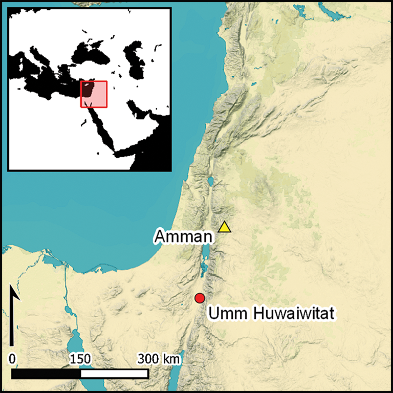
In 2019, the PTAP conducted excavations at the site known as Umm Huwaiwitat, 3.5km north of Petra's city centre, approximately 1km east of the ancient settlement and sanctuary of Ras Al-Silaysil, and some 2.5km to the south-west of the well-known Neolithic settlement at Beidha (Figure 1). The PTAP initially investigated Umm Huwaiwitat to understand the chronology of a series of extant and exposed walls used today as agricultural terraces. Our excavations revealed archaeological remains dating as far back as the sixth millennium BC and exposed phases of use extending to the present. Although there is no evidence that such use was continuous, the stratigraphic sequences nevertheless reveal a deep history of occupation and land use. This history is obscured in academic and popular writing by an emphasis on the Nabataean and Roman-period activity that is so conspicuous in the city of Petra. Here, we present the results of our investigations and analyses, focusing on the recently excavated evidence of Neolithic activity.

Figure 1. Map of the Petra region showing Neolithic sites (bold) and other places of interest (figure by the authors).
Umm Huwaiwitat
Umm Huwaiwitat is located near the western end of the Wadi al-Ghurab (Figure 2), approximately 800m east of where the wadi spills off the Petra Plateau into the Jordanian Rift Valley. At the top of this precipice lies the Nabataean/Roman settlement and sanctuary of Ras Al-Silaysil, while below it is the so-called Pond Temple (Lindner & Gunsam Reference Lindner and Gunsam1995a, Reference Lindner and Gunsam1995b). Cut into the sheer cliff face, an ancient path once allowed access to and from the plateau, leading scholars to propose that the Wadi al-Ghurab may have functioned as one of several routes in and out of the Petra Basin (Zayadine Reference Zayadine1992). Besides Ras Al-Silaysil proper, this western end of the Wadi al-Ghurab contains a great density of ancient terrace walls, wells, rock-cut cist graves and other structures. The chronology of these features is unclear but remains from the Neolithic through to the present day are found intermingled on the surface (Lindner & Gunsam Reference Lindner and Gunsam1995b; Knodell et al. Reference Knodell2017).
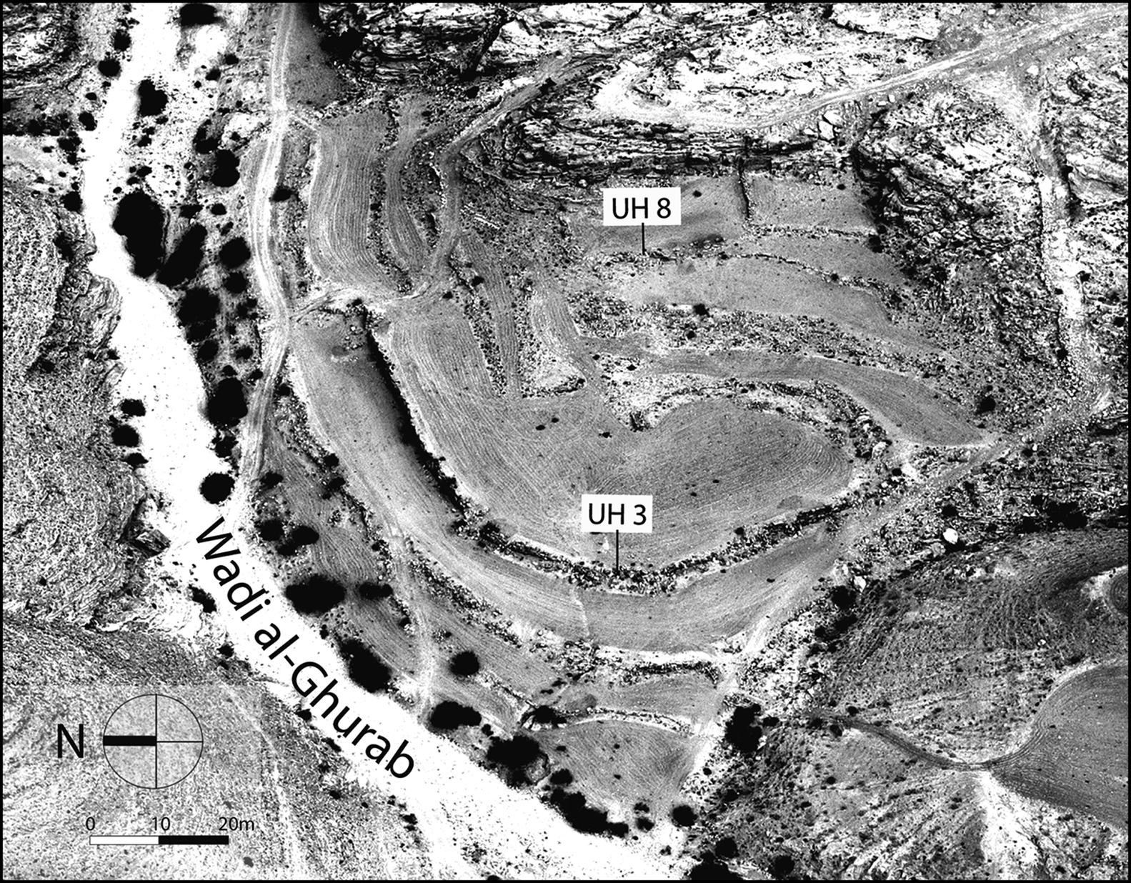
Figure 2. Aerial photograph of Umm Huwaiwitat (figure by the authors, image courtesy of Robert Bewley: APAAME_20191022_RHB-0396).
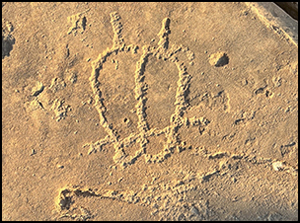
Umm Huwaiwitat means ‘site of walls’ in the local Bedouin dialect (ḥāʾiṭ: wall; ḥuwaywiṭ/ḥuwayṭ: wall [diminutive]) and refers here to a cluster of approximately 12 extant stone walls of various sizes, styles of construction and states of preservation (Zayadine Reference Zayadine1992: 222–23). The site covers an area of roughly 1ha that rises several metres above the current wadi bed. Petroglyphs of indeterminate date, including geometric drawings and pecked outlines of footprints (Figure 3), are found scattered on the rock outcrops that enclose the area on its southern and eastern sides. The western side of Umm Huwaiwitat is delimited by a small gully that today is dammed, while the northern side is bound by the bed of the Wadi al-Ghurab, along which several of the walls are oriented. These natural features contribute to making this area an effective trap for flows of sediment and water. From Umm Huwaiwitat there are clear views to Ras Al-Silaysil and the Rift Valley beyond.

Figure 3. Petroglyphs found around Umm Huwaiwitat (figure by the authors).
Wall UH3 (Figure 4) is the most conspicuous and best preserved of the walls at the site. It runs in an arc for approximately 200m and rises to a height of 2.45m above ground level. Our excavations have shown that an additional metre of its lower courses remains buried. It is built of coursed stone blocks and curves to enclose an elevated platform (approximately 0.75ha in area), which is visually and topographically delimited from the rest of the site.

Figure 4. Partial elevation and section of wall UH3 (figure by the authors).
At least five additional walls and a rectilinear structure (approximately 5 × 5m) sit atop this platform. The dates of construction and occupation of this structure are uncertain, but test-pits placed at its south-eastern corner and excavated down to the foundations revealed Nabataean/Roman ceramics. Most of the walls atop the platform are in a poor condition; the best-preserved sections remain standing to only one or two courses. The construction styles of the walls vary widely: some are single-faced and built of cobbles and irregularly sized stones, others are double-faced and constructed from larger boulders.
To investigate the chronological relationships between UH3 and the walls upon the platform it retains, we conducted excavations at wall UH8. In comparison to UH3 and other walls at Umm Huwaiwitat, the topmost courses of UH8 are built of large boulders (approximately 1 × 0.5 × 0.5m) and the wall itself is the widest recorded at the site (2.4m). Wall UH8 runs north-west to south-east for some 28m and roughly parallel to the nearby sandstone outcrops that define the eastern border of the platform. At occasional points along the length of UH8, small perpendicular walls connect it to these outcrops. UH8's relatively unusual appearance led us to excavate a test trench in an attempt to understand whether the stylistic differences between UH3 and UH8 could be correlated with differing construction periods or functions.
We excavated test pits both upslope (east) and downslope (west) of wall UH8, at its approximate midpoint, leaving the wall itself in situ (Figure 5). This investigation quickly revealed that the stones visible on the surface were only the most recent of several construction episodes. To the west of UH8 (downslope), we encountered a buried wall of coursed, roughly cut stones (on average 0.4 × 0.4 × 0.2m), offset from UH8 by approximately 0.7m and beginning roughly 0.5m below ground level; we followed this wall to its foundation, whose base was some 1m below the modern ground surface (Figure 6). To the east (upslope), excavation revealed an additional three courses of stones, similar in shape and style to those found on the surface. Below those courses were large, disarticulated stones, perhaps associated with the construction of an earlier wall or an earlier phase of UH8. Though our initial intent was to investigate the foundations and construction phases of UH8, we ultimately continued our upslope excavation 1.3m below wall UH8's lowermost courses. The considerable depth and composition of cultural deposits below UH8 indicated a long history of use and occupation, unlike elsewhere at Umm Huwaiwitat, where walls usually reached bedrock or sterile substrates at or just below their foundations. Subsequent analyses dated the deposits below wall UH8 to the sixth millennium cal BC; occupation at Umm Huwaiwitat therefore goes back to at least the Neolithic and the area appears to have long remained a significant place in the landscape.

Figure 5. A) plan of UH8; B: west–east (south facing) section of UH8, with photograph indicating the location of the radiocarbon and micromorphology samples (figure by the authors).
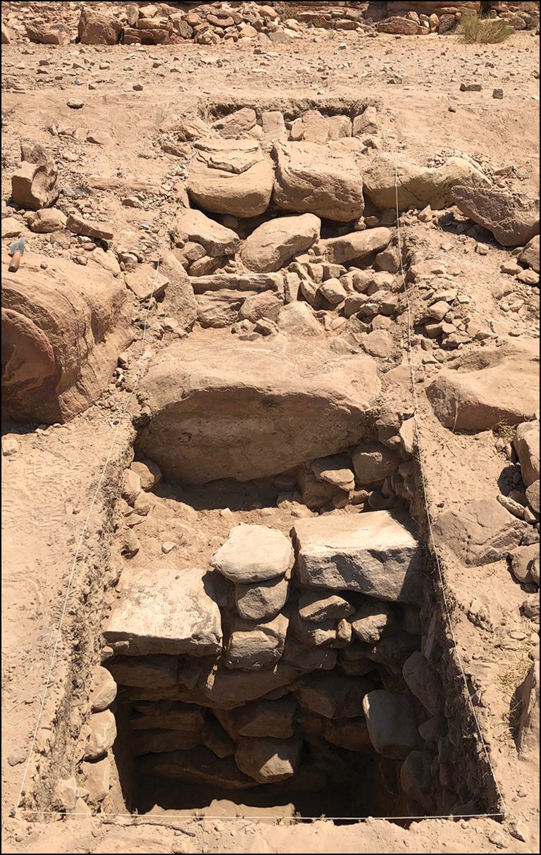
Figure 6. Photograph of UH8 during excavation, showing the boulders of the western exposed side of UH8 (in the centre ground; the large boulder on the far left, outside the trench, has a trowel resting on it, for scale); the roughly cut stones of an earlier wall under UH8 are in the foreground and the eastern (upslope) part of the trench is in the background (figure by the authors).
Results
The part of the trench upslope from wall UH8 gave us the deepest and most complete stratigraphic sequence. We identified seven distinct layers (see Figure 5B and below), from which all excavated soils were sieved and ceramic, lithics and bone fragments were collected. A total of 102 ceramic sherds, all from layers 1 and 2 and predominantly of Nabataean/Roman appearance, were recovered (Figure 7A). Lithic artefacts numbered 110; they were mostly from layer 3. Of these, Gary Rollefson analysed a selection of 14 and identified six as dating to late prehistory (6900–2000 BC); one of these implements was identifiable as an endscraper (Figure 7B). Long bone shaft fragments also came predominantly from layer 3. These were identified as non-human animal based on their size and density, but none included diagnostic areas or features that could be used for species identification. In addition, we collected soil samples for micromorphological study, radiocarbon and optically stimulated luminescence (OSL) dating, and archaeobotanical analysis.

Figure 7. Selected ceramics (A) and a lithic implement (B) recovered from excavation at Umm Huwaiwitat (figure by the authors).
Micromorphology
Four undisturbed and orientated blocks were collected for soil micromorphology analysis (Figure 5B). Thin sections were produced using standard methods (Beckman Reference Beckmann and Stahr1997) and described with the terminology of Stoops (Reference Stoops2003).
Layer 7 (1.94–2.03m below surface level (bsl hereafter)) is a layer of light brown sandy silt with charcoal fragments in its top part. Its lower boundary was not reached, and it was interpreted in the field as natural substrate. In thin section, however, it proved to be a cultural layer, enriched with charcoal and burnt soil fragments from hearths, carnivore/omnivore faeces and microscopic bone splinters. The sequence presented here thus begins with contexts already modified by human activity.
Layer 6 (1.86–1.94m bsl) is a dark brown layer rich in organic matter composed almost exclusively of herbivore dung, specifically a mixture of aggregates or ‘lumps’ of faecal spherulites (Canti Reference Canti1997) with still-recognisable (undecomposed) plant remains mixed with spherulites, and of aggregates of burnt herbivore dung. The latter, which is abundant in the thin section, can be recognised by the blackened appearance of several spherulites (Figure 8a & b), caused by burning herbivore dung, as attested experimentally (Canti & Nicosia Reference Canti and Nicosia2018). Abundant siliceous remains from algae in the animals’ drinking water (Chrysophycean stomatocysts; see Verleyen et al. Reference Verleyen, Sabbe, Vyverman, Nicosia, Nicosia and Stoops2017) were also observed within the dung as well as scattered in the groundmass, together with well-preserved phytoliths (Figure 8c).

Figure 8. (a) Blackened faecal spherulites in burnt dung, thin section D, Layer 6, Plane Polarised Light (PPL); (b) same as (a) in Cross Polarised Light (XPL); (c) Chrysophycean stomatocysts (siliceous residues from algae ingested by animals with drinking water) within herbivore dung (arrows), thin section D, Layer 6, PPL; (d) whole faecal pellet, with partially digested plant fragments identifiable as sheep/goat dung, thin section B, Layer 4, PPL; (e) example of burnt bone fragment indicating domestic activities connected to ash production, thin section C, Layer 5, PPL; (f) detailed view of wood ash, with calcite pseudomorphs of former plant oxalates, thin section A, Layer 4, PPL (figure by the authors).
Layer 5 (1.81–1.86m bsl) has a well-separated granular structure composed of several aggregates (20–30mm in size) of dung burnt to ash, often fused or even vitrified. A few well-preserved dung pellets can be identified as sheep or goat faeces (Bronniman et al. Reference Brönnimann, Nicosia and Stoops2017) (Figure 8d).
Layer 4 (1.57–1.81m bsl) is a brown, organic-rich layer similar to Layer 6, but with a higher quantity of whole faecal pellets, also identified as sheep or goat dung. The well-preserved faecal pellets in Layers 4, 5 and 6, without signs of trampling or compaction in the thin section, indicate the regular dumping of burnt dung rather than in-situ deposits within livestock pens. Microscopic burnt bone fragments from cooking activities, found throughout the sequence, further suggest that the ash and dung came from the cleaning out of domestic hearths or campfires.
Layer 3 (1.33–1.57m bsl) is an ash-rich, powdery layer that, in contrast to earlier layers, primarily consists of wood ash. It is noticeably different from layers 4–7 in thin section, with distinctive calcite pseudomorphs formed by the thermal decomposition of plant oxalates (Canti & Brochier Reference Canti, Brochier, Nicosia and Stoops2017; Figure 8f) and several fragments of wood burnt to ash. Charcoal—the product of the incomplete burning of wood—is also more abundant in comparison to other layers. Herbivore dung reduced to ash is still attested in Layer 3, but in significantly lower quantities than in other layers. Finally, Layer 2 (2.00–1.33m bsl) and Layer 1 (0–0.20m bsl) correspond, respectively, to the foundation and fill of UH8 and the ploughed topsoil. No micromorphological study was conducted on these layers.
Radiocarbon and OSL dating
A combination of radiocarbon and optically stimulated luminescence (OSL) dating was conducted on the stratigraphic sequence associated with UH8 (Tables 1 & 2). Results suggest at least three distinct phases of deposition and activity at Umm Huwaiwitat. Layers 6 and 7 date to the early sixth millennium cal BC, with samples from both layers returning mostly overlapping dates. Two samples from Layer 3 date to the late sixth millennium BC and are again mostly overlapping. The OSL dating of sediments from Layer 2, directly below the lowest courses of wall UH8 (one sample upslope and one sample downslope from UH8), gives results in roughly the fourth millennium cal BC, providing a terminus post quem for the earliest phases of UH8.
Table 1. Umm Huwaiwitat radiocarbon dates, calibrated with OxCal v.4.4.4 (Bronk Ramsey Reference Bronk Ramsey2009) and the IntCal20 atmospheric calibration curve (Reimer et al. Reference Reimer2020).

Table 2. Umm Huwaiwitat OSL dating.

Phytoliths
We collected four 1.0l soil samples from Layers 2, 3, 4 and 7 for phytolith analysis (Figure 9), which was conducted at the PaleoResearch Institute in Colorado, USA (Cummings & Varney Reference Cummings and Varney2021). Analyses of the well-preserved phytoliths (based on the ratio of short to long cells) reveal high counts overall, with relatively abundant festucoid phytoliths indicative of grasses growing in cool or temperate habitats, particularly in the layers associated with dung and ash deposits (Layers 3–6). Such grasses include wild and domesticated cereals, though the precise identification of species is difficult based on phytoliths alone. Dendritic long-form cells, however, represent only 2 per cent of the total phytoliths present, far below the 7–8 per cent threshold usually used to identify domesticated cereals in phytolith assemblages (Albert et al. Reference Albert2008). Such a low percentage may indicate that animals were grazing on wild grasses. On the other hand, a study of phytolith assemblages from modern cattle and buffalo dung in arid parts of northern India shows that low representation of dendritic long-form cells may indicate that animals were consuming primarily leftovers from cereal crop processing, such as culms and leaves (Lancelotti & Madella Reference Lancelotti and Madella2012). These by-products, of little value for human consumption or fuel, would have been a readily available resource for animal fodder. Morphotypes that correspond to wetland plants, such as reeds and sedges, are almost entirely absent, as are diatoms and sponge spicules indicative of the presence of water.

Figure 9. Phytolith diagram of samples from UH8 excavation at Umm Huwaiwitat (figure courtesy of the PaleoResearch Institute).
Discussion
Our investigations at Umm Huwaiwitat document multiple phases of occupation, forms of land use, and episodes of wall construction in a single location, starting more than six thousand years ago. Based on its construction style, wall UH3 was probably built during the Nabataean/Roman period. Wall UH8 was probably used and modified at that same time, being built atop earlier walls that date as far back as the Early Bronze Age, during which time other nearby sites were occupied (Lindner et al. Reference Lindner, Hübner and Genz2001; Vella et al. Reference Vella2012; Hübner Reference Hübner2020). The many walls, building foundations, petroglyphs and other architectural features at Umm Huwaiwitat attest to the natural and cultural importance of this area, as do earlier traces of Neolithic activity and use. Such traces are not evident on the surface but are an essential part of the site's history.
Micromorphology indicates that Layers 3–6 contain large quantities of herbivore dung and ash. These layers were probably generated from the repeated dumping of waste from nearby fires fuelled with herbivore dung. Since the Umm Huwaiwitat thin sections showed no indicators of trampling or compaction, it is unlikely that dung and ash formed and accumulated in situ (see Shahack-Gross Reference Shahack-Gross, Nicosia and Stoops2017). Moreover, the evidence suggests that the animals which produced the dung deposited below UH8 were not grazing in wet environments. While the dung did contain stomatocysts, which were probably ingested by animals drinking water from shallow, stagnant pools, there is otherwise no evidence of the consumption of hydrophilous vegetation (e.g. reeds, sedges). It therefore seems likely that the dung deposits were produced by animals that were grazing primarily in dry, upland areas, or that they were being selectively foddered with by-products of crop production. Both scenarios suggest some degree of animal management.
Finally, the approximately 700-year long period between Layers 3 and 6 suggests recurrent use of the site throughout the sixth millennium cal BC. This was a time of increasing aridity and settlement dispersal (Rollefson Reference Rollefson and Adams2008; Rambeau et al. Reference Rambeau, Mithen and Black2011; Finlayson & Makarewicz Reference Finlayson, Makarewicz, Enzel and Bar-Yosef2017), with a greater focus on nomadic pastoralism relative to the preceding Pre-Pottery Neolithic periods (Rollefson & Köhler-Rollefson Reference Rollefson and Köhler-Rollefson1992). The study of ash in thin section reveals a change in fuel choice during this period, from an almost exclusive reliance on herbivore dung c. 5900–5750 cal BC to mostly wood, with minor quantities of dung, c. 5200–4900 cal BC. This shift deserves further research, as it might denote a greater availability of wood in the late sixth millennium BC, indicative of wetter conditions, or a change in animal management strategies with less reliance on pastoralism.
The discovery of layers dated to the sixth millennium cal BC was an unexpected result at Umm Huwaiwitat but human activity from this and earlier periods is attested in the vicinity (Gebel Reference Gebel, Garrard and Gebel1988). The Brown University Petra Archaeological Project recorded a “nearly ubiquitous” (Knodell et al. Reference Knodell2017: 664) distribution of chipped-stone artefacts dating to the Late Neolithic across much of the area north of Petra, which reflects the magnitude and extent of human activity during that period. Evidence for Neolithic sites, rather than artefacts, in the Petra region are few, however, though include Beidha, Shkarat Msaied, Baʾja, Sabra and Basta (Rollefson Reference Rollefson and Adams2008) (see Figure 1).
Neolithic Beidha, located only 2.5km north-east of Umm Huwaiwitat along the course of the Wadi al-Ghurab (Kirkbride Reference Kirkbride1966; Byrd Reference Byrd2005) provides a useful point of reference for our findings. The chronology of Beidha is contested (Birch-Chapman et al. Reference Birch-Chapman, Jenkins, Coward and Maltby2017; Finlayson & Makarewicz Reference Finlayson and Makarewicz2018), but the prevailing view is that the site was occupied in the Middle Pre-Pottery Neolithic B (8300–7200 cal BC), during which time there were at least three discernible phases of occupation. Rollefson (Reference Rollefson and Adams2008: 93) has also argued for an additional phase during the Pre-Pottery Neolithic C (6900–6300 cal BC), on the basis of architectural similarities between Beidha and the settlement of ‘Ain Ghazal, best known for its ritually deposited plaster statues (Grissom Reference Grissom2000). One radiocarbon sample from Beidha also dates to cal 5500 BC, though it is often excluded from consideration as it comes from an insecure context (Rambeau et al. Reference Rambeau, Mithen and Black2011: 251).
The most recent layers of Beidha were destroyed sometime in the first few centuries AD by the construction of ‘Nabataean’ terraces, further complicating efforts to reconstruct the Neolithic chronology of the site (Byrd Reference Byrd2005: 7). Even so, the spatial and temporal proximity (if not overlap) of Beidha and Umm Huwaiwitat provides a useful framework for contextualising our results, particularly given how thoroughly Beidha has been studied. Analysis of that site's botanical remains has shown, for example, the prevalence of emmer wheat and barley, which are likely to have grown on the alluvial terrace below the site (Helbaek Reference Helbaek1966). As discussed above, it is unclear from the phytolith assemblage at Umm Huwaiwitat whether the high representation of festucoid forms is indicative of animal grazing in cool uplands or whether it is the result of animals eating or being fed the by-products of crop processing. The presence of cultivated barley and emmer wheat at nearby Neolithic Beidha nevertheless indicates that such by-products were at some point present in the landscape and could have been a useful source of fodder for animals.
As for faunal remains, caprines dominate the assemblage at Beidha (Hecker Reference Hecker1982). Precise identification of species at that site was difficult due the absence of cranial remains, but they are most similar to those of ibex or wild goats. Despite the absence of morphological traits characteristic of domestication, the mortality profiles indicate selective management of herds for meat, with a high proportion of adolescent males. Based on these results, Hecker (Reference Hecker1982) has argued against a strict wild versus domesticated dichotomy, preferring ‘cultural control’ as a more appropriate way of framing the management of these animal species. As he argues, the natural terrain around Beidha would have made it easy to manage caprine herds without formal penning, for which there was no evidence at Beidha. The presence of dense dung deposits at Umm Huwaiwitat provides further detail regarding local forms of animal management during the later Neolithic. Taken together, the geomorphological and archaeobotanical evidence suggests that people actively managed the pasturing and foddering of their animals. Though the microstratigraphy indicates that the dung is likely to have been collected from elsewhere and redeposited, it is possible that the animals were penned nearby, since caprines would have been domesticated by Late Neolithic times (Makarewicz & Mahasneh Reference Makarewicz and Mahasneh2020).
Conclusions
The Late Neolithic history of the Petra region is much less well-known than the region's Nabataean/Roman history, not least because the Late Neolithic is elusive in Jordan (Rollefson Reference Rollefson and Adams2008). Nevertheless, some pockets of activity, such as that identified at Umm Huwaiwitat, provide windows into life in the region at that time. The collection and burning of dung and deposition of ash at Umm Huwaiwitat reflect the importance of animals in local subsistence strategies and perhaps also growing concerns about fuel resources in the later sixth millennium BC. Complementing data from Neolithic Beidha, which was probably already abandoned by this time, our results provide some insight into the long-term histories of animal management, land use and human settlement in the Petra region.
Our findings also point to the longevity and intensity of use and modification of a topographically, hydrologically and culturally salient place. Much as observed at Neolithic Beidha, Umm Huwaiwitat shows multiple phases of occupation and reuse; but our findings also caution against uncritically classifying features and spaces—such as the walls we have test-excavated at Umm Huwaiwitat—as agricultural solely because that is how they are used today. Agriculture was but one of Umm Huwaiwitat's many uses through time, and perhaps only a recent one (though see Kuijt et al. Reference Kuijt, Finlayson and MacKay2007). The dense and organically rich soils that developed as a result of occupation during the Late Neolithic may have attracted later use of the site, as evidenced by the construction of wall UH8 in the fourth millennium BC. Subsequent interventions, particularly the construction of wall UH3 in the Nabataean/Roman period, further transformed a place that had already been significant for millennia before. Yet, there is little about the morphology or positioning of walls UH8 or UH3 that indicates that they were originally built as agricultural terraces. The history of Umm Huwaiwitat is a testament to the long-term, incremental and accretionary development of landscapes, with soils and structures changing function as local communities adapt them to suit shifting needs. In contributing to the study of Petra's history, our investigations at Umm Huwaiwitat highlight the considerably earlier foundations upon which much of its later agricultural landscape was built.
Looking beyond Petra, such findings complement and contribute to the growing recognition that anthropogenic transformations of the Earth's surface often have far older origins than previously assumed—especially at a site such as Petra, where archaeological investigations tend to target a narrow temporal range. Those early and under-investigated transformations often have impacts that persist into the present (Ellis et al. Reference Ellis2021). Although infrastructural land modifications such as terraces are frequently the most salient forms of human manipulations of the landscape, they are rarely the earliest. To better understand terraces in general, and the agricultural landscapes in which they are situated, we must look to their antecedents.
Acknowledgements
We thank the Department of Antiquities of the Hashemite Kingdom of Jordan, the Petra Archaeological Park and the American Center of Research (ACOR) for their support, as well as Fatima, Lidia and Haroun in Umm Sayhoun for their hospitality. Radiocarbon testing was conducted at the Poznan Radiocarbon Laboratory in Poland. OSL dating was conducted at the Technical University of Denmark in Copenhagen. We also thank Marta Dal Corso for help with phytolith data, Gary Rollefson for analysis of the lithics, and Elias Muhanna and Ahmad Al-Jallad for their linguistic insights. Finally, we are grateful to the members of the 2019 PTAP: Sara AlRabiah, Justin Han, Jenna Ingersoll, Evan Levine, Max Peers, Daniel Schneider, Abigail Stoner and Kelley Tackett.
Funding statement
The Petra Terraces Archaeological Project is funded by Brown University and the University of Chicago.


 Open access