


James Croll's life (1821–1890) spanned a period which saw major developments in our understanding of the science of the Earth, and he, Charles Lyell (1797–1875), Archibald Geikie (1835–1924) and James Geikie (1839–1915) all made significant contributions to these developments, especially with respect to glaciation. Briefly, Charles Lyell initially gave his reputation and status to the concept of land-ice glaciation (Lyell Reference Lyell1840) as proposed by Louis Agassiz in 1840 (although Lyell subsequently rejected this view and reverted to the belief that icebergs and floods could produce evidence now attributed to glaciation; Lyell Reference Lyell1875); Archibald Geikie wrote the first clear, coherent and authoritative review of glacial deposits in the British Isles (Geikie, A. Reference Geikie1863) and subsequently steered this science through his professorship in Geology at Edinburgh University and Director, then Director General of the British Geological Survey; James Croll introduced physical principles to our understanding of climate change (as opposed to biblical and geological mechanisms) and James Geikie gave the glacial theory global status and authority through his definitive (for the time) text on The Great Ice Age (Geikie, J. Reference Geikie1894), his role in establishing the Scottish Geographical Society in 1884 (given Royal status by Queen Victoria in 1887) and his activities as President of the Society from 1904 to 1910.
The background, connections, experience and knowledge of these individuals varied. Lyell and the Geikies inherited a privileged education and travelled widely (including visits to currently glaciated areas). In contrast, Croll attended the local village school and was largely self-educated. Croll was initially employed as a wheelwright, tea merchant and temperance hotelier before becoming janitor at the Andersonian Institute in Glasgow in 1859 and then administrator at the Geological Survey in Edinburgh in 1867. Furthermore, their achievements were variously acknowledged. Both Lyell and Archibald Geikie received knighthoods and James Geikie was appointed to the distinguished Murchison Chair of Geology at the University of Edinburgh and President of the Royal Scottish Geographical Society, whereas James Croll, although he was elected a Fellow of the Royal Society, had a career that was diminished by ill health and acute modesty. He ended his life in virtual poverty having been refused an appropriate pension by the Civil Service. Nevertheless, all valued the landscape and geology (although Croll actually denied an interest in geology; Irons Reference Irons1896, p. 14, see below), and this shaped their thoughts and provided the evidence to test of their concepts. Common to all is the region of central Scotland, especially the Glasgow area and the region that extends E of Glasgow to Edinburgh and NE to the Vale of Strathmore.
5wThis paper explores the ways that James Croll, the Geikies and Charles Lyell related to the field evidence (glacial sediments and landforms) for glaciation and Quaternary climate change. It places their work in the context of: (i) Croll's cultural, geographical and geological heritage, and (ii) the little acknowledged, but very distinguished ‘Glasgow School’ of glacial geologists who influenced Croll's geological thinking. It then examines the records of field evidence presented by Croll, the Geikies and Lyell for the existence of ‘land-ice’ glaciation and interglacials, and the ways this evidence was used to develop an acceptable concept for Quaternary glaciation, glacial geomorphology and Quaternary Science.
Croll's contribution to the glacial theory was the introduction of a theory of climate variability based on changes in the Earth's orbit. This allowed predictions of the frequency and timing of climatic changes with glacial episodes interrupted by interglacial periods (Croll Reference Croll1875; Imbrie & Imbrie Reference Imbrie and Imbrie1986). Over the time when Croll and colleagues did their work there was little discussion of the concept of an interglacial other than a period of time in which the climate, environment, fauna and flora were not glacial, and the sea level was different from the present. It was not until the publication of the third edition of James Geikie's The Great Ice Age (Geikie, J. Reference Geikie1894) that the concept of glaciation and interglacial was given a structure that would be considered applicable today.
1. Croll's cultural, geographical and geological heritage
James Croll's early history is well reported because it was unusual for such a distinguished scientist (Irons Reference Irons1896). He grew up in the village of Wolfhill, N of Perth, in the Vale of Strathmore, in an area that contains a fascinating glacial history (Fig. 1). Although there is no direct evidence to suggest that he was directly influenced by this glacial landscape, it is interesting to reflect that so much of what he believed has since been demonstrated from the area of his upbringing.

Figure 1 A DEM (NEXTMap Britain data from Intermap technologies Inc. were provided courtesy of NERC via the NERC Earth Observation Data Centre) of the western end of Strathmore and the lower Tay valley and firth. The figure shows the location of Wolfhill where James Croll spent his childhood, and Perth, which was his nearest town. The glacial landforms of the area of Croll's upbringing are illustrated by a northern light source showing glacial lineaments across the entire region except the lowlands around the Firth of Tay. The lineaments in Strathmore consist of elongate and squat drumlins formed by a SW–NE ice movement, and the lineaments in the Highland Boundary region and the Sidlaw Hills are crag-and-tail relating to resistant bedrock obstructions. The channel and floodplain of the rivers Tay and Almond are also shown, along with Almondbank where a succession of glacial and marine deposits provide evidence for two episodes of glaciation and the designation of the Perth Readvance (see text for further details).
Around Wolfhill, the Vale of Strathmore is an area of very low relief. To the E it shows SW–NE trending lineaments which are low-relief glacier bedforms/elongate drumlins, demonstrating the SW to NE flow of a powerful ice stream across this part of the region. To the W of Wolfhill the texture of the landscape is also lineated, but in this case the lineaments are less elongate and have a SW–NE trend in the S, changing gradually to an E–W trend further N. These are also glacier bedforms, but in this case they form classic, if relatively small and low relief, drumlins, indicating less dynamic ice movement. At the northern margin of Strathmore, and in the adjacent Highland boundary region, the lineaments show both elongate and rounded forms. Here, they trend NW–SE at the N, changing progressively to E–W further S. Many have a promontory at the W end, indicating a bedrock hill. Similar forms exist in the Sidlaw Hills at the S side of the Vale of Strathmore, also with a bedrock hill at the W end and a distinctive ‘tail’ to the E. These also are glacier bedforms but with a resistant bedrock obstruction allowing them to be defined as crag and tail, and indicate that ice moved out of the southern Grampian Highlands from the NW then eastwards towards the mouth of the River Tay. Croll, therefore, grew up in an area of complex glacial activity with, at the later stages of glaciation by the last Scottish ice sheet, Highland ice streaming from the NW to the E to be replaced as the ice thinned, by western central Scottish ice streaming N-eastwards towards the Aberdeenshire coast.
Further study of this digital elevation model (DEM) (Fig. 1) shows that Croll also grew up in an area shaped by the effects of river activity in the form of low-relief floodplains and incised channels. The latter are particularly distinctive in the area around Wolfhill where the River Tay has cut a clearly visible channel through the glacial landforms and deposits. From Croll's point of view, as recorded in many subsequent publications, areas like this are very important as they provide natural sections by which he and his geological colleagues were able to study the sediments and infer the processes of deposition. Indeed, only 8 km SW of Wolfhill on the N bank of the River Almond, c.600 m W of the old road bridge, Simpson (Reference Simpson1934) described a sedimentary succession that represented two glacial advances separated by marine sediments and was part of the evidence that suggested to him a glacial advance known as the Perth Readvance – vindication of Croll's concept of multiple glaciations. Also from the point of view of Croll's upbringing, the glacial processes produced a well-drained sandy till derived from the Devonian sandstones and siltstones of the region, and enabled his family to make a living from a half-acre piece of land at Wolfhill. A W–E-trending Late Carboniferous tholeiite dyke outcrops just N of Wolfhill, but clearly this had no influence on the young James Croll, reflecting his inherent lack of interest in geology, as discussed below.
2. Croll and the ‘Glasgow School’ of glacial geologists
In 1857, as a result of a serious illness afflicting his wife, James Croll moved to Glasgow, and in 1859 was appointed janitor of the Anderson College and Museum (University of Strathclyde since 1964). This appointment allowed Croll to have much free time, and access to a large library that included scientific texts. It also brought him in contact with a community which had become a focus for the study of what we now call Quaternary Science. It is not surprising, therefore, that in his autobiography (Croll, in Irons Reference Irons1896, p. 32) he wrote:
the question of the cause of the Glacial epoch was being discussed with interest among geologists. In the spring of 1864 I turned my attention to this subject; and … it occurred to me that the change in the eccentricity of the earth's orbit might probably be the real cause. I accordingly drew up a paper on the subject, which was published in the Philosophical Magazine for August 1864. (Croll Reference Croll1864)
This development arose despite the fact that the James Croll that headed to Glasgow had said (Croll, in Irons Reference Irons1896, p. 14):
There were two important … sciences for which I had no relish, namely, chemistry and geology, more particularly the latter. The reason was that to me they appeared so full of details and so deficient in rational principles, being so much sciences of observation and experiment.
Croll's remarkable change of interest can be ascribed to the fact that the citizens of Glasgow were at the forefront of observations, communications and debate about the study of glacial landforms and deposits. That this culture influenced Croll is re-enforced by his statement, when in 1867 he was persuaded to take up the position of librarian and administrator (‘resident surveyor and clerk in the office’ in the terminology of the time) at the Geological Survey in Edinburgh (Croll, in Irons Reference Irons1896, p. 35):
This [appointment] relieved my mind from having to study a science for which I had no great liking. There was, however, one department of geological inquiry with which the physical questions, in which I was then engaged, required that I should be acquainted, namely, surface geology, or drift in its bearings on Glacial and Interglacial periods.
It is, therefore, relevant to examine the members of the ‘Glasgow School’ and their influence. They were a wide range of individuals, including quarry managers, engineers, ministers of the church, journalists, businessmen and gentlemen of leisure. The ‘school’ may be said to have originated with James Smith of Jordanhill (1782–1867) (Hoffman Reference Hoffman2015) who was from a wealthy family of West India merchants and was interested in the Mollusca of the Clyde Beds that are found above and below sea level around western Scotland. Smith recognised that many species of shell present in the Clyde Beds were no longer to be found in the seas around Scotland, but only in what are now arctic regions. He therefore deduced that the climate had once been colder than at present, and these original views were communicated to the academic community through presentations and papers (Smith Reference Smith1836), but also locally through his role as President of the Andersonian Institute and of the Glasgow Geological Society.
It was in relation to this intellectual context that the British Association for the Advancement of Science hosted its annual meeting in Glasgow in 1840. At this meeting, James Smith presented a lecture outlining his findings, and Louis Agassiz (1807–1873) presented a lecture in which he proposed that land-ice had extended from the mountains into and across lowland regions, something hitherto not considered in Britain. Both presentations were momentous in their concepts, but the effect of Agassiz's lecture was enhanced vastly because he departed the meeting on a tour of the West Highlands of Scotland in the company of the distinguished Professor William Buckland (1784–1856) of Oxford, in order to test the proposition put forward in his lecture. Buckland had joined him as a sceptic, believing that the features and sediments attributed to glaciation were formed by marine currents associated with dramatic changes of land and sea level. Nevertheless, as a result of their excursion, Buckland was converted to the ‘glacial theory’ and departed from Agassiz to visit his friend, the equally distinguished Professor Charles Lyell of King's College London, who was at home in Strathmore. As a result of this visit, Lyell was also persuaded to accept the glacial theory and proceeded to do fieldwork in the local Highland valley of Glen Clova and the adjacent part of Strathmore. The outcome of this activity was that Agassiz, Buckland and Lyell presented lectures supporting land-ice glaciation to a very sceptical, indeed hostile, audience at the Geological Society of London (Davies Reference Davies1969; Boylan Reference Boylan1998). Indeed, McCallien (Reference McCallien1941, p. 316) wrote:
The results of the Scottish tour were communicated to the Geological Society of London in November 1840. Sir Archibald Geikie has said that the views expressed by Agassiz and Buckland “were violently opposed and sarcastically ridiculed”.
Hence, the science presented at Glasgow was tested, challenged and accepted. It was then taken to London where it was rejected.
Over the next 35 years Glasgow was the ‘hot-house’ of glacial geology and the alternative views (conventional and incorrect) had little effect on this community, which in 1858 stimulated the foundation of the Geological Society of Glasgow. The resulting publication of the Transactions of the Geological Society of Glasgow then became a focus for publications on glacial landforms, deposits and associated organic material (Braithwaite Reference Braithwaite2011). Ironically, the next breakthrough was proposed by Charles Maclaren (1782–1866), an Edinburgh journalist and geologist, but was based on field evidence in the form of a raised beach cut into a moraine ridge at Rhu Point in the Gareloch, NW of Glasgow (Maclaren Reference Maclaren1842). This was the concept of glacial eustasy, by which the volume of ice over the Earth determines global sea level, and changes in ice volume cause changes of sea level.
At this time also, excavations in the Glasgow district for the creation of canals, docks, railways, mines, quarries and building foundations resulted in the creation of excellent exposures in glacial deposits and in the discovery of plant and animal remains within and between these deposits. This is clearly reflected in Archibald Geikie's seminal paper, ‘On the phenomena of the glacial drift of Scotland’ (Geikie, A., Reference Geikie1863), and the importance of organic materials associated with these deposits is indicated by a 14-page appendix at the end of the text. These studies were replicated by the work of many and reported in the Transactions. Those who influenced Croll whilst he was resident in Glasgow and subsequently in Edinburgh are cited below. They include David Robertson (1806–1896) who began life as a ‘herd laddie’ on a farm in Ayrshire, and the Rev Henry Crosskey (1826–1893) who was born in southern England but became a Uniformitarian Minister in Glasgow from 1852 to 1869. Robertson and Crosskey were authors of numerous publications relating to the glacial and associated organic deposits of the region around Glasgow and the Firth of Clyde. Robertson was a pioneer in the study of marine and freshwater shells and provided careful descriptions of the Quaternary deposits of the Glasgow area (Brady et al. Reference Brady, Crosskey and Robertson1874), and Crosskey published high-quality descriptions of glacial and associated organic deposits (Crosskey Reference Crosskey1865, Reference Crosskey1868). Likewise, quarrymaster Robert Craig (1822–1901) of Beith in Ayrshire, and James Bennie (1821–1901) of Glasgow, a former handloom weaver and subsequently an officer of the Geological Survey in Edinburgh, published papers on similar topics within the Transactions of the Geological Society of Glasgow – descriptions that still remain important for Earth Science (Bennie Reference Bennie1868; Young & Craig Reference Young and Craig1869; Craig Reference Craig1871). Bennie worked closely with James Croll, providing him with results from his geological surveys and joining him in the field to study evidence critical to their thoughts. In many ways the work of Robert Jack (1845–1921) of Irvine, Ayrshire, brings together the importance of this type of study and gives authority to Croll's climate change science. In 1875, whilst working for the Geological Survey, Jack reported on the already known (Geikie, A. Reference Geikie1863, p. 70) organic material between glacial deposits at Croftamie, SE of Loch Lomond and NW of Glasgow, and proposed that ‘[t]his deposit is interglacial, or preglacial – most probably interglacial’ (Jack Reference Jack1875, p. 25), spelling out specifically, with clear unambiguous evidence, the case for glaciation and climate change so necessary for Croll's orbital forcing model. This site subsequently contributed to the understanding, timing and dating of the period associated with the last advance of glaciers in Scotland (Rose et al. Reference Rose, Lowe and Switzur1988; Coope & Rose Reference Coope and Rose2008; MacLeod et al. Reference MacLeod, Palmer, Lowe, Rose, Bryant and Merritt2011).
It is also worth referring to Dugald Bell (1827–1896) who was born in Lanarkshire and employed as a cashier in businesses in the Vale of Leven and Glasgow. Bell also provided excellent descriptions of glacial deposits and landforms (Bell Reference Bell1874, Reference Bell1885), but he is known best for his scathing critiques of the submergence concept considered by many, and David Milne-Home (1805–1890) in particular, to be responsible for the formation of unsorted deposits, striated boulders and rock outcrops, and the entrainment of organic fragments from a pre-existing landscape. These critiques were enhanced by linguistic skills developed as a Free Church preacher.
Finally, it is critical to stress the very great importance of Archibald Geikie in the development of these ideas. Although not of Glasgow, and not really part of the ‘Glasgow School’, he valued Croll's concept of climate change and was responsible for Croll's move to the Geological Survey in Edinburgh in 1867. Geikie's paper in the Transactions of the Geological Society of Glasgow in 1863 gave clarity and authority to the ‘glacial theory’ in a form that had not previously existed, and in his autobiography Croll stated:
The director [of the Geological Survey], Mr. Geikie, I found to be a most agreeable person. This was all along a great comfort to me. During the thirteen years we were together in the office, never so much as an angry word passed between us. (Croll, in Irons Reference Irons1896, p. 35)
3. Lyell, the Geikies and Croll's observations on terrestrial glacial sediments and landforms
The field observations published by Lyell, the Geikies and Croll will be dealt with in chronological order as they are largely stimulated by the concepts and intellectual challenges of the time. Actually, the sum total of field work in the form of surveys, field mapping and descriptive papers is not great. In the case of Charles Lyell and the Geikies, their thoughts were greatly influenced by travel, and observations made during these travels are reflected in the contents and frequent revision of their important books (Lyell, Principles of Geology, 12th edition, two volumes, 1875; Elements of Geology, sixth edition, Reference Lyell1865; Geikie, A., The Scenery of Scotland, third edition, Reference Geikie1901; Geikie, J., The Great Ice Age, third edition, 1894; Antiquity of Man in Europe, 1914).
3.1. Charles Lyell
The views of Charles Lyell on what are now known as ‘terrestrial glacial sediments and landforms’ can be found in the early editions of ‘Principles of Geology’ first edition (Reference Lyell1830–1833) and ‘Elements of Geology’ first edition (Reference Lyell1838). In these, he outlined his ‘uniformitarian’ principles in which he attributed these sediments and landforms to processes that can currently be observed operating on the Earth's surface, and he specifically stated that unsorted deposits (diluvium, drift) were the product of deposition on a seabed following submergence, and that their subsequent position above sea level was due to changes in the level of the land caused by tectonic forces. Striations, that had attracted much attention, were considered to be due to boulders in the icebergs rubbing against bedrock, or rubbing against one another. However, as a result of his travels to Switzerland, and his association with Louis Agassiz, Lyell had been introduced to the consequences of glacial activity (land-ice, in the terminology of the time), and it was with this background he received William Buckland, newly converted to the glacial theory, at his family home at Kinordy near Kirriemuir in Strathmore (see above).
As a result of the ideas proposed by Agassiz at the Glasgow meeting of the British Association for the Advancement of Science, and the visit of Buckland, Lyell carried out fieldwork in the region of Glen Clova, N of the town of Kirriemuir in the area of the SE Grampians and eastern Strathmore (Fig. 2), an area not too distant from where James Croll grew up (Figs 1, 2). Arising from this fieldwork, Lyell presented a paper to the Geological Society of London that provided clear descriptions of glacial landforms and sediments and attributed these features, without qualification, to:
glaciers [that] not only existed a long time in the Grampians, but extended even into the low country; and, further, that in his (sic) opinion, immediately antecedent to the present epoch, there may have been great oscillations of climate in the Northern Hemisphere. (Lyell Reference Lyell1840, p. 199)
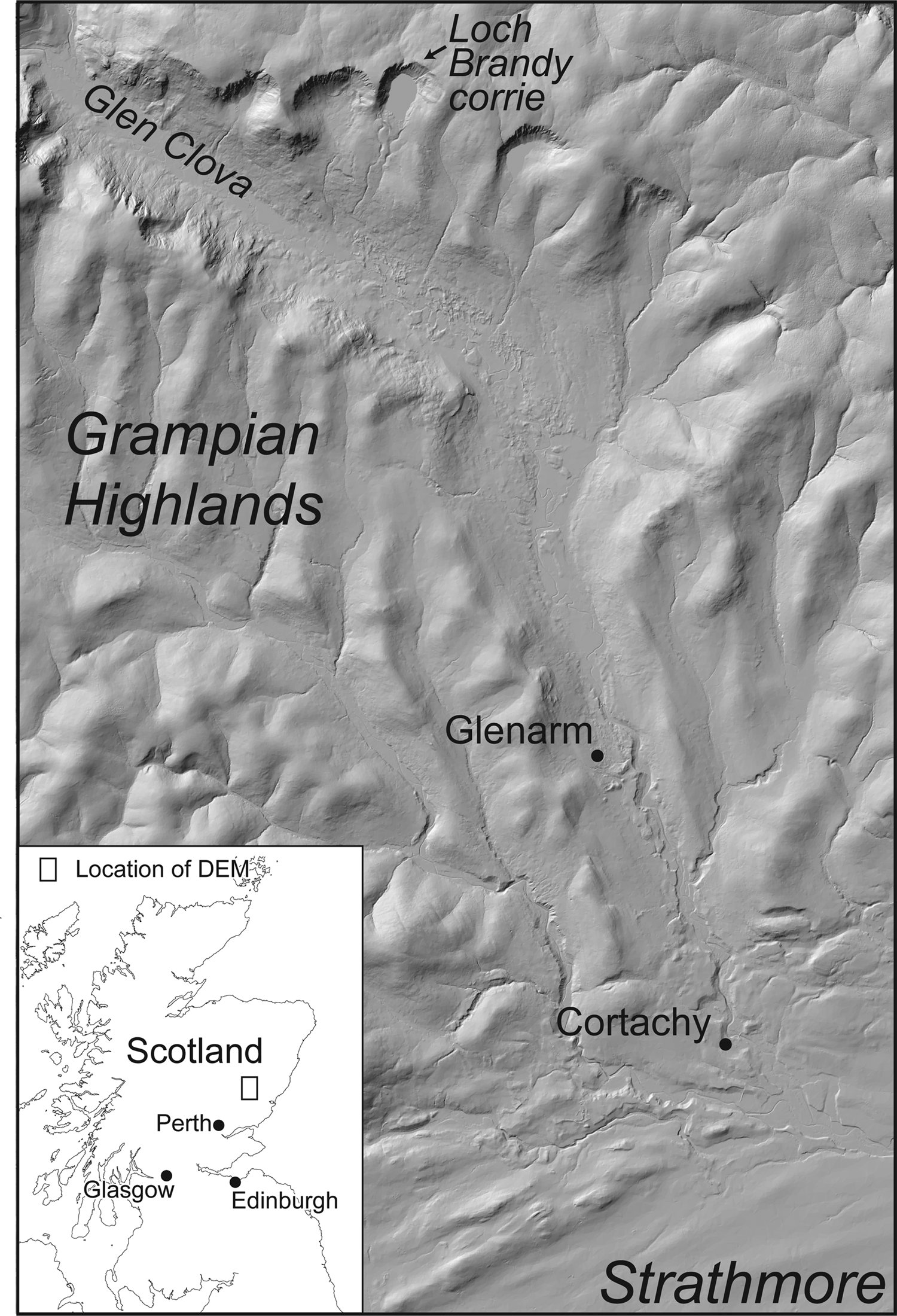
Figure 2 A DEM (NEXTMap Britain data from Intermap technologies Inc. were provided courtesy of NERC via the NERC Earth Observation Data Centre) of the middle and lower part of Glen Clova in the southeastern Grampian Highlands, areas described by Charles Lyell in his paper, ‘On the geological evidence of the former existence of glaciers in Forfarshire’ (Lyell Reference Lyell1840). Loch Brandy, Glenarm (Glenairn in Lyell Reference Lyell1840) and Cortachy (Cortachie in Lyell Reference Lyell1840) are referred to in the text and show, respectively: (i) a glacially eroded basin; (ii) an ice-tongue basin, moraine ridge and outwash accumulation; and (iii) an area of extensive superficial deposits and dead-ice landforms. All of these were attributed by Lyell to the effects of land-ice glaciation moving NNW to SSE from the highest parts of the Grampian Highlands. Even the longitudinal ridges in Strathmore are related to transported matter formed by a glacier moving from SW to NE.
This paper is published in two outlets (Proceedings of the Geological Society of London and The Edinburgh New Philosophical Journal), and the document appears to be a report of Lyell's lecture rather than a paper written directly by him (hence the use of third person in the above quotation). Apparently Lyell did write and submit a full paper on the subject, but subsequently withdrew it following the hostile response of the learned society and respected colleagues (Boylan Reference Boylan1998, p. 156).
In his lecture, Lyell compares the Grampian highlands with the Alps, Strathmore with the great valley of Switzerland and the Sidlaw Hills with the Jura. He also draws analogy between Grampian erratics found on the Sidlaw Hills with the Alpine erratic blocks observed in the Jura. Description of all the glacial deposits and features in the area is remarkably clear and perceptive and borne out by recent field studies (Mitchell & Guild Reference Mitchell and Guild2019). For instance, he refers to corrie landforms near the head of Glen Clova (Fig. 2) and explains the origin of the Loch Brandy corrie and the associated moraine ridge:
if the cavity occupied now by water was once filled with a body of ice it is easy to account for the transport of large boulders from the northern to the southern side of the cavity, and their mode of distribution beyond it. (Lyell Reference Lyell1840, p. 200)
Also in Glen Clova (Fig. 2), in the area of Glenarm (Glenairn), he identifies features that would now be interpreted as an ice-tongue basin, moraine ridge and outwash accumulation to be formed by ‘a retreating glacier’ (Lyell Reference Lyell1840, p. 201). Likewise, in the Cortachy (Cortachie) area, where a number of valleys join Strathmore (Fig. 2) and there are extensive superficial deposits and dead-ice landforms caused by the convergence and decay of the juxtaposed Grampian and Strathmore glaciers, he clearly describes ‘a great amount of unstratified detritus, full of Grampian boulders deposits, and covered, for the most part, with stratified sand and gravel’ (Lyell Reference Lyell1840, p. 201) and attributes this to the ‘union of three or four large glaciers’ (Lyell Reference Lyell1840, p. 201).
Even within Strathmore, where the evidence is more subtle and indeed best shown on digital imagery such as the NEXTMap DEM (Figs 1, 2), he describes:
many longitudinal ridges, some of which are 200 or 300 feet above the adjacent valleys. They are generally covered with till and erratics, derived from the Grampians, and partly from the subjacent old red sandstone [sic] …. This boulder till … forms invariably the lowest part of the transported matter in the Strath. (Lyell Reference Lyell1840, p. 201)
In terms of our present understanding, these features are either large, elongate drumlins or bedrock controlled lineaments along the Highland Boundary Fault zone (Fig. 2), but the glacial process responsible for their formation is clearly implied by Lyell and does his science great credit.
It is unfortunate that the views expressed above were soon abandoned by Lyell. In subsequent publications he reverts to his uniformitarian concept, although in a modified form (Chorley et al. Reference Chorley, Dunn and Beckinsale1964; Boylan Reference Boylan1998). This modification required the involvement of icebergs derived from regions where high-latitude glaciers entered the seas. His concept invoked that these icebergs contained material within and on their surfaces and transported these materials over the region covered by the drifting icebergs. Boulders within the icebergs thus striated the bedrock surfaces and the release of the material, as an iceberg melted, contributed to the formation of the unsorted superficial deposits (drift). Further, the action of icebergs on the drift caused clasts to rub against one another and become striated, and the effects of currents within the submerged zone caused the formation of bodies of sorted sand and gravel. These views persisted through to Lyell's later publications and in Elements of Geology the Student's Series (Reference Lyell1871) he returns to field observations at Cortachie and includes a drawing and written description of localised deformation structures in drift that would now be interpreted as loading structures. Although acknowledging that they may have been produced by ‘the mechanical pressure of an advancing glacier’ (Lyell Reference Lyell1871, p. 179), he prefers to attribute them to the effects of icebergs deforming seabed sediments, because ‘the sideway thrust of huge islands of ice running aground against sandbanks…[means that] the banks may not be at all disturbed by the shock’ (Lyell Reference Lyell1871, p. 180).
As a consequence of his observations and interpretations in his 1840 reports, Lyell deserves to be acknowledged as a pioneer in glacial geology. However, this status is much diminished by his reversion to the iceberg theory within the uniformitarian concept, and the long-term rejection of his 1840 land-ice concepts. Indeed, within the sphere of geological thinking, there is a case for suggesting that Lyell should be known for holding back the acceptance of the glacial theory.
3.2. Archibald Geikie
Archibald Geikie's observations on terrestrial glacial sediments and landforms are to be found in ‘On the phenomena of the glacial drift of Scotland’ (1863), The Scenery of Scotland (1865) and in ‘Memoirs of the Geological Survey (Scotland)’, of which Sheets 22 (Geikie, A. et al. Reference Geikie, Geikie, Jack and Etheridge1871), 23 (Geikie, J. et al. Reference Geikie, Peach and Geikie1873) and 31 (Geikie, J. et al. Reference Geikie, Peach and Geikie1879) are the most relevant. Archibald Geikie was concerned with the whole scope of glacial geology as then understood, and his relevant observations, based on his own fieldwork or by the acknowledged reference to the work of Charles Maclaren (of glacial eustasy, see above), Robert Chambers (1802–1871) and T. F. (Thomas) Jamieson (1829–1913), are numerous and cover the whole of Scotland. Here, attention will be given primarily to the observations from the areas relevant to the work of James Croll.
Archibald Geikie's observations are focused on the issues (as he saw them) of: (i) the initial ice cover of the whole of Scotland; (ii) the submergence of Scotland up to a level of c.2000 ft (c.700 m); and (iii) the renewed glaciation of the mountains and valleys of Scotland. The first is particularly important to this paper.
Pages 13 to 100 of the ‘glacial drift of Scotland’ paper are a most powerful scientific evaluation of the case for land-ice glaciation of Scotland. The first part of this section (pp. 13–73) is entirely descriptive (clearly stated by the author) without any tendency towards interpretation and circular arguments. It draws attention to: (i) striations on pebbles, boulders and bedrock and their regional directions; (ii) the rounding of bedrock surfaces in the direction facing the mountain regions of the country; (iii) crag-and-tail landforms with notice of the bedrock core of the tail; (iv) rock basins; and (v) glacial deposits located between bedrock strata or below far-travelled slabs of bedrock. He even identified the existence of ‘long, smooth-backed ridges [that] follow each other in endless succession’ (Geikie, A. Reference Geikie1863, p. 32).
In the next part of the descriptive section (pp. 34–73) he concentrates on the properties of the unsorted deposits (till, boulder-clay) that cover so much of Scotland and, in particular, the Central Lowlands. He draws attention to the colour of the matrix in relation to the underlying bedrock, the frequency of clast lithologies relative to the proximity to the underlying lithology (even providing quantitative data, p. 44) and the roundness of the clasts in relation to source rocks. He notes also that there are striations on all sides of the clasts, and that there are sorted sediments below and within the tills. Of particular interest to him is the Chapelhall area to the E of Glasgow where an extensive body of sand, 20–30 ft (6–9 m) thick, within the till, was being mined for the creation of moulds needed by the local cast-iron industry. His descriptions from within the mine are limited because of the poor lighting, but he highlights the fact that in some places the sand is totally undisturbed and typical of deposition by a river, and that within the contact zones, the sand can be deformed and mixed with the till (pp. 58–63). He also notes that in the Chapelhall area there are records of shelly red-clay (at an altitude of 510 ft (155.5 m) above sea level), and also organic deposits, although he was not able to observe them himself. The issue of organic remains in the form of shells, mammal bones and plant remains is also given attention, including reference to the deposits at Croftamie subsequently described and interpreted by Robert Jack (see above, Jack Reference Jack1875), at Kilmaurs in N Ayrshire (Young & Craig Reference Young and Craig1869) and in the tills of Caithness (see below, Peach Reference Peach1863).
These relationships lead him to conclude that ‘ice existed, not as mere local glaciers descending the chief valleys, but as one wide sheet covering the whole country…’ (Geikie, A. Reference Geikie1863 p. 78), and that this ice ‘must have been a plastic agent that could adapt itself to the crevices of a cliff or of a ravine, pressing equally on a hollow and prominence, everywhere rounding off and smoothing even the hardest rocks’ (p. 76). He goes on to say that ‘when a direction of transport is indicated by the materials of the boulder-clay, it [is] found to coincide with the trend of the striation on the rocks of the district’ (p. 89). He emphasises the relationships between the till and the underlying bedrock, and the correspondence between the orientation of the long axis of larger clasts in the till and the direction of striations, attributing this to ‘a natural tendency to arrange themselves in the position in which they would undergo the least friction’ (p. 89). To explain the presence of sorted sediments such as the sands and clays of Chapelhall, he states that ‘[t]he stratified beds in the till indicate, apparently beyond a doubt, the existence of streams and lakes during that period’ (p. 92). All of the conclusions based upon the evidence outlined above lead him to conclude that ‘[f]ew now seriously hold the belief, that the phenomena of the Drift are due to a vast cataclysmal deluge, or to any number of deluges’ (p. 73).
In the subsequent section of the 1863 paper (pp. 100–54) Archibald Geikie is far less confident about his science (something he acknowledges), and indeed has a tendency to mix observation and interpretation and invoke untested processes. The issue under consideration is the ‘stratified drift’ and stoneless clays, and the belief that these deposits, along with the associated landforms, formed after Scotland had been submerged beneath the sea to a level c.2000 ft (c.700 m) above the present sea level. This is assumed to have occurred after the glaciers, so clearly vindicated above, had retreated to higher parts of the mountains (p. 144). The crux of the argument is that stratified deposits were formed by coastal processes as sea level subsided, and that the deposits and landforms become younger as they become lower. The key reason for this interpretation is that Geikie was not aware of the concept of ‘ice-contact sedimentation’ and was seeking alternative processes for these deposits that covered large areas of the surface of Scotland.
In the main, descriptions in this section are not as clear as those that precede them, but this is not the case for the Carnwath-Carstairs area in the central southern part of the Midland Valley (Fig. 3). Here (pp. 112–15), he describes the features, which are widely known as the Carstairs Kames (see Huddart & Bennett (Reference Huddart and Bennett1997) and Thomas & Montague (Reference Thomas and Montague1997) and references therein), as:
[a ridge] running in a sinuous course, with here and there a short spur running out on either side, and with one or two lateral basins, merges into a group of confluent ridges, which continue in the same direction for more than three miles farther. Those ridges are connected together by transverse bars at irregular intervals. Hence there results a net-work of anastomosing sand bars and mounts, enclosing an endless succession of basins, from two to three feet, up to two or three hundred yards in diameter, and their bottoms some sometimes sixty or eighty feet below the crest of the surrounding ridge. (Geikie, A. Reference Geikie1863, pp. 113–14) (Fig. 3)
He then states that:
A kame consists almost entirely of sand and gravel, varying in texture from the finest grain to a coarse aggregate of boulders. These materials, except in rare cases, are stratified. They often alternate with each other in rapid succession; thin layers or laminae of sand are intercalated in the gravel beds, and occasional seams of gravel vary the stratification of the well-bedded masses of sand. The sands, moreover, are as a rule full of diagonal lamination or current bedding. It seems plain, therefore, that the currents of water must have played some part in the accumulation of these sedimentary deposits. (Geikie, A. Reference Geikie1863, p. 114)

Figure 3 A DEM (NEXTMap Britain data from Intermap technologies Inc. were provided courtesy of NERC via the NERC Earth Observation Data Centre) of the Carstairs Kames near Lanark, central Scotland. These landforms were described in detail in Geikie's (Reference Geikie1863) paper and ascribed to processes operating during the fall of sea level after the submergence of Scotland following land-ice cover, although he is far from happy about this interpretation, saying that they could have been formed by ‘some other agent of whose concurrence we do not at present suspect’ (Geikie Reference Geikie1863, p. 116). In this case he is correct, because the concept of ice-contact sedimentation was not yet understood. These highly distinctive ridges are considered to have been formed by an anastomosing network of meltwater rivers flowing in a supraglacial environment and the intervening depressions are interpreted as the position of isolated blocks of glacier ice.
The difficulties challenging Geikie in this area of science are neatly summarised in his own assessment of the processes of formation:
When the true solution of the origin of these perplexing ridges is discovered, we shall probably find it a complex one, involving not only the tides and currents of the sea, but of drifting ice; perhaps, too, in some cases, of the floods caused by melting snows, and possibly of some other agent of whose concurrence we do not at present suspect. (Geikie, A. Reference Geikie1863, pp. 115–16)
With the benefit of modern understanding of glacial processes, Huddart & Bennett (Reference Huddart and Bennett1997, p. 467) suggest that the Carstairs Kames were formed by glacial meltwater ‘sedimentation in a supraglacial environment, controlled by a topography of ice-cored ridges’.
Elsewhere, Archibald Geikie's work is not so relevant to the topic of this paper. In particular, the section of his 1863 paper on renewed glaciation of the mountains and valleys of Scotland is concerned with regions largely beyond those studied by James Croll.
3.3. James Croll
As explained above, James Croll had no inherent love of geology, but he was determined to test his concept of climate change (Croll Reference Croll1864), and with this in mind he compelled himself to examine the drift and associated landforms of Scotland. Following Archibald Geikie (Reference Geikie1863), he was a firm believer in the land-ice concept, but he felt that there was still a need to validate the interglacial concept and his believe that there had been a number of glaciations. However, fieldwork did not come easy to James Croll. As his friend and field colleague James Bennie stated, on a visit to Blairdardie Clayfields in NW Glasgow on 20 April 1867: ‘Mr. Croll had a horror of rain, and would not go out in it’ (Irons Reference Irons1896, p. 155). Nevertheless, Irons (Reference Irons1896) reports that whilst at the Andersonian Institute:
Croll had for many years been making frequent excursions into the country in search of glacial phenomena, and had thus acquired an extensive and accurate knowledge of surface geology, or drift in its bearings on Glacial and Interglacial periods. (p. 148)
Irons (Reference Irons1896) goes on to say that ‘[h]e visited and inspected all the glens, river banks, and seashores in the neighbourhood of Glasgow’ (p. 153). Apart from some passing references to the deposits and landforms around the western end of the Kelvin Valley in NW Glasgow and around the area of Kilsyth between the firths of Clyde and Forth, there are very few records of his observations and many of the descriptions that relate to his field activities are better provided by James Bennie (Reference Bennie1868) than by Croll himself. This is something that Croll encouraged when he wrote a letter to Bennie on 14 January 1868, requesting that:
A short paper, or a long one if you can find time, on the subject [of the drift deposits around Glasgow] might be the means of interesting some of the able and energetic members of the Glasgow Geological Society to direct their attention more exclusively to the surface geology of the neighbourhood. Certainly there is not a spot in the kingdom where the surface deposit may be studied to better advantage than around Glasgow. (Irons Reference Irons1896, p. 178)
The observations of Croll (Reference Croll1869) and Bennie (Reference Bennie1868) in the Kilsyth area remain of interest, providing a description of the glacial deposits and landforms in that area. The best account is reported in a letter to Bennie on 13 August 1868 (Irons Reference Irons1896, p. 193), where he notes that:
I have gone over the ground from Kilsyth to Castlecary, and I find it very interesting. The district is covered with sand and gravel knolls … and the mounds are almost covered in some places with huge blocks of trap [basic igneous] rocks. The quantity of boulders lying on the face of the country here is something remarkable. The following are the dimensions of one measured yesterday: length, 13 feet; breadth, 12 feet; height, 9 feet. I have measured, I suppose, nearly 100 with the tape line; 30 feet in circumference, and from 6 to 8 feet in diameter, is quite a common size.
He does not take these observations any further, other than to ascribe them to land-ice processes. The form and composition of the knolls and mounds are shown in Figure 4 along with a NEXTMap Britain DEM that shows the landforms of the area, and, in particular, the position and character of the Kelvin Valley.

Figure 4 Landforms and sediments in the area of Kilsyth and the Kelvin Valley, central Scotland, observed and recorded by James Croll in 1868. (A) Location of Kilsyth within Scotland. (B) A view from Croy Hill towards the NW and across the Kelvin Valley to Kilsyth and the Campsie Fells in 1967. The hills above Kilsyth that face southwards and form part of the Campsie Fells are known as the Kilsyth Hills (see (C)). The Kelvin Valley was recognised by Croll, as a result of his study of borehole records, to be the location of a buried valley. The deposits infilling this buried valley provided for him evidence for multiple glaciations. (C) A DEM (NEXTMap Britain data from Intermap technologies Inc. were provided courtesy of NERC via the NERC Earth Observation Data Centre) of the Kelvin Valley in the watershed area between Kilsyth and Banknock. As a result of mapping in 1967, the area of alluvium, which identifies the buried valley in this area, is shown in yellow; and the area of ‘sand and gravel knolls; and the mounds [which] are almost covered in some places with huge blocks of trap [basic igneous] rocks’ (Croll in Irons Reference Irons1896, p. 193) is shown in brown. Also shown are glaciofluvial meltwater channels and drumlins on the Kilsyth Hills. It should also be noted that there is much disturbance to the landscape by quarrying and the creation of spoil heaps. (D) The boulder-covered mounds NE of Kilsyth. (E) A section in the boulder-rich till of the Kilsyth area. At other locations in the area the till has larger boulders and a sandier matrix, and the hummocks are formed of sand and gravel (Rose & Smith Reference Rose and Smith2008).
Despite these references to the surface geology, Croll is frustrated by the absence of longer sequences, which he feels are necessary to test his interglacial hypothesis. Thus, whilst he was at the Andersonian Institute he is reported as stating that:
the short sections, were of little use in giving an idea of the time represented by the surface deposits, were, in fact, too short for any estimate to be founded on them, and that the entire thickness could only be found out by the study of bores, or pit shafts, which went to the rock-head. (Irons Reference Irons1896, p. 153)
With his attention turned to the records provided by the drilling of boreholes, the construction of mine shafts and the observations from within mines, he discovered that in the area of the present valleys of the rivers Kelvin and Bonny, there exists a ‘trough [which is] the channel of two rivers which, starting from near the middle of Scotland, ran the one into the Firth of Forth and the other into the Firth of Clyde’ (Irons Reference Irons1896, p. 153) (Fig. 5). This buried trough was of immense importance to Croll and he states that ‘[d]uring the latter part of the summer of 1868 I spent two or three weeks of my holidays in tracing the course of this buried trough from Kilsyth to the river Forth at Grangemouth’ (Croll Reference Croll1869, p. 335) (Figs 4, 5), with further details given in Bennie (Reference Bennie1868). Both the Croll and Bennie papers report the collection of about 250 records of boreholes and shafts and state, almost with excitement, that:
Twenty of these bores have one boulder-clay, with beds of stratified sand or gravel beneath the clay; 25 have two boulder-clays, with stratified beds of sand and gravel between; 10 have three boulder-clays; 1 has four boulder-clays; 2 have five boulder-clays; and 1 has no fewer than six separate masses of boulder-clay, with stratified beds of sand and gravel between; 16 have two or three separate boulder-clays, differing altogether in colour and hardness, without any stratified beds between. (Croll Reference Croll1869, p. 331)

Figure 5 The buried valleys of central Scotland. (A) This is part of a figure published in Croll (Reference Croll1869, fig. 1). The area extends from the Firth of Clyde in the W to the Firth of Forth in the E, and is N of the centre of Glasgow. In the caption on this figure: ‘The stippled parts represent the area which would be covered by sea were the land submerged to the extent of 200 Feet’; and ‘The heavy black lines A [and] B … represent buried River Channels’. (B) A reconstruction of the buried landscape of central Scotland, N of the centre of Glasgow. The area extends from Bowling in the W to Bonnybridge in the E, and is based on the borehole records available in the region up to 1968. Work based on more recent data (Kearsey et al. Reference Kearsey, Lee, Finlayson, Garcia-Bajo and Irving2019) gives much more detailed information than that shown above, but does not include a reconstruction of the buried topography. Here, (B) clearly shows the buried valley first identified by James Croll. It does, however, suggest that the valley has an irregular ‘up-and-down’ thalweg and was most probably eroded by glacial meltwater flowing under an eastward moving ice sheet, or by direct glacial erosion.
This, to Croll, is a vindication of multiple glaciations and his interglacial concept, as the stratified beds are considered to have formed during interglacial periods.
In his 1869 paper, Croll gives little attention to the geology of the buried channel and sediments, but engages in a detailed discussion of the hydrodynamics necessary to produce the buried channel using, as appropriate, clearly stated assumptions relating to catchment size, channel gradient, river discharge and velocity. This is a clear expression of his conceptual, as opposed to geological, thinking (see above). Using hydrodynamic conclusions, and dismissing the effects of ice and the sea (Croll Reference Croll1869, p. 338), he states that ‘[t]here is no other way of explaining the origin of this hollow, but upon the supposition of its being an old river bed’ (Croll Reference Croll1869, p. 339). Consequently, he makes inferences about the level of the sea during the glacial/interglacial period and in a letter to James Bennie on 11 September 1868 concludes that at the time the bottom of the trough was formed, ‘the land stood at least 260 feet higher in relation to the sea than at present’ (Irons Reference Irons1896, p. 196).
Most of this work was done while Croll was living in Glasgow and employed at the Andersonian Institute, but in November 1867 he moved to Edinburgh to work for the Geological Survey. With this move, Croll expressed in a letter to James Bennie on 11 November 1867 that ‘I purpose to begin outdoor work on the surface deposit around Edinburgh’ (Irons Reference Irons1896, p. 175), and, indeed, in a subsequent letter to Bennie on 24 July 1868 he stated:
In one of my evening strolls, which have been rather few of late, I met in with a most interesting example of stratified bed of sand and mud in the Boulder Clay. The sand bed is between two tills and contains wood fragments. (Irons Reference Irons1896, p. 191)
However, his interpretation that the organic material represents an interglacial period was challenged by Ben Peach (1842–1926) of the Geological Survey, based on concepts that include submergence and icebergs (Irons Reference Irons1896, pp. 191–92).
Even though he was in poor health, Croll continued to be determined to prove his concepts and, specifically, that the whole of Scotland was covered by land-ice. For this purpose, he made a journey to the top of Allermuir Hill (elevation 493 m) SW of Edinburgh, where he observed, at the summit, the presence of striations on bedrock beneath a thin layer of till, and concluded that ‘land ice in the form of a sheet, cover[ed] the whole face of the country’ (report by James Bennie in a paper read to the Physical Society of Edinburgh, on 18 April 1883, in Irons Reference Irons1896, p. 254).
This determination to prove the glacial theory, and indeed his belief that British and Scandinavian ice filled the whole of the German Ocean (North Sea), led Croll to write a two-part paper (Croll Reference Croll1870) on the ‘boulderclay of Caithness’. In this, he uses the high-quality field observations of T. F. Jamieson and Ben Peach and concludes that the shelly till that covers parts of Caithness was deposited by land-ice that moved N-westwards from the Moray Firth after originating in the Highlands of Scotland. Such a pattern of ice movement explained the shells within the till and the lithological and fabric properties of this deposit, as provided by the field records. Detailed seabed imagery carried out by Bradwell et al. (Reference Bradwell, Stoker, Golledge, Wilson, Merritt, Long, Everest, Hestvik, Stevenson, Hubbard and Finlayson2008), recent detailed fieldwork (Merritt et al. Reference Merritt, Hall, Gordon and Connell2019) and a substantial long-term study of the glaciation of Great Britain and Ireland (Clark et al. Reference Clark, Ely, Greenwood, Hughes, Meehan, Barr, Bateman, Bradwell, Doole, Evans and Jordan2018) have vindicated Croll's interpretation.
3.4. James Geikie
There is relatively little overlap between the field areas studied by James Croll and James Geikie, although Geikie spent six years of his life living in Perth (1876–1882), close to the area of Wolfhill and Croll's youth. However, James Geikie travelled widely in the British Isles, continental Europe and North America, and recorded the glacial geology seen during his travels. He also spoke, or was able to translate, several languages so that the findings from other nations contributed to his concepts, either by personal observation or by correspondence (Newbigin & Flett Reference Newbigin and Flett1917). These observations, publications and concepts are documented, often in some detail, in his books (Geikie, J. Reference Geikie1894, Reference Geikie1909, Reference Geikie1914) and significantly influenced his thinking on the subject. Indeed, the pattern that emerges is that the scientific interests of James Geikie extend far beyond conventional glacial geology but include other aspects of geology, geography, geomorphology, biology, zoology and archaeology, and he was conscious of the many proxies these sciences use to determine past climates, biodiversity, human activity and surface processes. He was also aware of the relevance of these sciences to society and, indeed, applied his skills to issues such as water supply in Gibraltar (Ramsay & Geikie, J. Reference Ramsay and Geikie1878). He was, in every sense, a ‘Quaternary Scientist’.
Like his brother Archie, James Geikie worked for the Geological Survey from 1861 until 1882, when he followed his brother to become Professor of Geology at the University of Edinburgh. Following this appointment he had to curtail routine field mapping, but took the opportunity to expand his interests in other regions and other parts of Earth Science. He also communicated his interests to students through entertaining lectures and fieldwork, and he showed wisdom in 1890 by ‘add[ing] to his university work proper a course for women, who were as yet excluded from classes within the building’ (Newbigin & Flett Reference Newbigin and Flett1917, p. 116).
His appointment as an officer of the Geological Survey fortuitously coincided with a:
change in the policy of the Survey …. Previous[ly] … the loose superficial deposits in Scotland had been ignored by the surveyors …. It was decided, chiefly on economic grounds, especially in connection with agriculture, that not only should the … superficial deposits be in future mapped along with the solid geology, but that the areas already surveyed should be re-mapped, with the object of adding the omitted beds. (Newbigin & Flett Reference Newbigin and Flett1917, p. 20)
With this new requirement in operation, he was directed to Fife and the Lothians, the Ayrshire and Lanarkshire coalfield regions and the Borderlands of Peebleshire and the Cheviots, and it was here that he made his observation on terrestrial glacial sediments and landforms (Geikie, A. et al. Reference Geikie, Geikie, Jack and Etheridge1871; Geikie, J. et al. Reference Geikie, Peach and Geikie1873, Reference Geikie, Peach and Geikie1879). He did so fully conversant and in agreement with the concepts put forward by his brother (see above, Geikie, A. Reference Geikie1863) and James Croll (see above, Croll Reference Croll1864), but he published few field observations that added to their concepts. What he did publish, he did with vigour, engaging in debate with those who held contradictory views and, more importantly, he added other scientific proxies to the resolution of glacial processes, the history of glaciation and Quaternary climate change.
James Geikie's first publication relevant to this paper is not concerned with rocks or landforms, but with peat. He sees this as a proxy for climate and topographic change and relevant to his concept of the ice age and to Croll's concept of climate change. This paper is subsequently noted and valued by Lewis (Reference Lewis1907) as a major botanical work on Scottish peat mosses. Essentially, James Geikie notes that ‘peat mosses appear to contain the record of certain changes of climate, which have not hitherto fully engaged attention’ (Geikie, J. Reference Geikie1867, p. 363), and records that many peat deposits include remains of trees. He also notes that peat grows in locations such as ‘along the sea-coast, [where] observers have noted the occurrence below high-water mark of tree-roots fixed in a soil, and frequently covered over with peat moss’ (p. 365). Elaborating on these observations, using basic ecological and geological concepts, he concludes that:
(i) at some period in the past our island must have been exceedingly well wooded (p. 365);
(ii) ‘there has been: a general loss of land …. Thus, over a very large area, we have proofs of a process of submergence which … has materially diminished the extent of dry land in the north-west of Europe’ (p. 366); and
(iii) ‘that the death of the trees, instead of being succeeded by the appearance of another generation, should invariably give rise to a peat moss. The explanation of this anomaly ought to be attributed to a change of climate. [This] continental condition of Britain … followed upon the close of the glacial epoch’ (p. 375).
With respect to the growth of peat, he also concludes that ‘the present aspect of our peat mosses will convince any geologist that this formation has not only ceased to spread, but is in most cases rapidly disappearing’ (Geikie, J. Reference Geikie1867, p. 381) and ‘[i]t can be shown that the destruction of our ancient forests has not been primarily due to man, although in the later stages of the process he certainly played an important part’ (p. 384).
James Geikie's publications on the glacial deposits of the areas relevant to this paper are restricted to one site, although other sites, the consequence of research by others in Scotland, are recorded in The Great Ice Age (Geikie, J. Reference Geikie1894, pp. 89–160). This site is at Crofthead, near Neilston in the Cowdon valley SW of Glasgow. The exposures were observed during the excavation of a railway cutting. They reveal two tills with intervening laminated clays and sand containing mammal and plant remains (Fig. 6), and were, therefore, relevant to the ongoing debate about glaciation and interglacials (Geikie, J. Reference Geikie1868a, Reference Geikieb, Reference Geikie1869). Geikie's descriptions are detailed, clear and relevant, and include, in addition to the usual lithological properties indicating the far-travelled provenance of clasts within the tills, a description of the presence of deformation structures on the upper part of the laminated sediments. He concludes with the statement that ‘the crumpling had been caused by pressure from above, for underneath the crumpled beds (which were confined to the top of the section), the clay and sand were quite undisturbed’ (Geikie, J. Reference Geikie1868b, p. 74).

Figure 6 Field sketches of sections at Crofthead, SW of Glasgow, showing sorted sediments with the remains of Bos primigenius between two tills in the valley of the Cowdon Burn. These sketches form figures 1 and 2 in Geikie, J. (Reference Geikie1868a). Other versions of these figures are shown as figures 1 and 2 in Geikie (Reference Geikie1870) and as figure 36 of The Great Ice Age (Geikie, J. Reference Geikie1894), and a figure showing the deformation structures at the top of the sorted sediments is shown in Geikie, J. (Reference Geikie1869). James Geikie considered these sections to be clear evidence of multiple glaciations and intervening interglacials and was concerned to demonstrate that the two tills were formed by two separate glaciations rather than the upper till being the product of a marine submergence and deposition from icebergs, or by mass movement from the adjacent hillside.
Although James Geikie, like his brother and James Croll, had no doubts about the former presence of land-ice and interglacial intervals, others were not convinced, and the fact that members of the Geological Society of Glasgow considered the uppermost till to be a landslip deposit (Geikie, J. Reference Geikie1870) elicited the response that ‘the force which squeezed and puckered [the laminated sediments containing the mammal and plant remains] must have acted in a direction down and not across the valley’ (Geikie, J. Reference Geikie1870, p. 55). Debate continued, and the issue of:
How … such loose stuff as gravel, sand, and silt [could] withstand the grinding action of a superincumbent ice-sheet …. And how, if these deposits have been thus traversed by ice, can we reconcile that with our belief in the excavating power of an ice-sheet? (Geikie, J. Reference Geikie1878a, p. 74)
continued to challenge James Geikie (Geikie, J. Reference Geikie1871, Reference Geikie1878a, Reference Geikieb). The crux of his riposte is based on a geomorphological analogy observing that the ‘denuding powers of running water is opposed to the belief that the same water also deposits and accumulates detritus while it flows’ (Geikie, J. Reference Geikie1878a, p. 74). This debate persisted, to the extent that in 1895 he delivered a scathing and scientifically wide-ranging attack on the distinguished geologist and palaeobotanist Clement Reid who had challenged the in situ origin of the Crofthead beds (Reid Reference Reid1895; Geikie, J. Reference Geikie1895).
The geomorphological observations of James Geikie extend throughout his work and underpin his interpretations of the glacial deposits and landforms. In 1868, at a time when many still rejected the concept of land-ice, he wrote:
by reference to what is taking place in arctic and alpine regions [we can understand that] the rounded contour of our hills, the flutings and sculpturings of our valleys, the scratched and polished rock-surfaces that everywhere abound, bear emphatic testimony to the former passage of a great sheet of moving ice. (Geikie, J. Reference Geikie1868c, p. 56)
Within this context, he explained the origin of drumlins: ‘the broad backed undulations of the boulder clay are… irregularities produced by the varying pressure and movements of the old ice-sheet’ (Geikie, J. Reference Geikie1868c, p. 73); and the imbricate pattern of pebbles deposited by rivers, which are ‘arranged precisely as we should expect them to have been by streams and rivers’ (Geikie, J. Reference Geikie1871, p. 551). Although it must be stressed that at the time these observations were published he still believed that ‘there can be no doubt whatever that the vast bulk of the upper drift deposits has been amassed below the level of the sea’ (Geikie, J. Reference Geikie1868c, p. 62). Consequently, he had to state that ‘surface arrangement into parallel mounds [drumlins] is not unfrequently due to marine denudation during a period of submergence’ (Geikie, J. Reference Geikie1868c, p. 61); and
[that] it is not uncommon to meet with large erratics and sporadic heaps of moraine-like matter in the very heart of beautifully false-bedded sand and fine gravel. Sometimes, indeed, the sand and gravel seem to pass into a kind of earthy till. This latter, which is undoubtedly the droppings from floating ice. (Geikie, J. Reference Geikie1868c, p. 62)
Nevertheless, it is clear that he is challenged by this issue, and could not but observe ‘[h]ow ridges and mounds of sand and gravel, for instance, came to retain so perfectly their peculiar outline during the re-elevation of the land is, to say the least, mysterious' (Geikie, J. Reference Geikie1868c, p. 67).
All of the above explanations and challenges persist through to his review of the Quaternary history of Europe (Geikie, J. Reference Geikie1892), but these explanations change with the third edition of The Great Ice Age (Geikie, J. Reference Geikie1894, pp. 607–61). In this text, he has no reservation in stating that the ice age was a time of frequent climate changes that were reflected in multiple glaciations, changes of sea level as seen by raised shoreline landforms and deposits around present coastal margins and changes in atmospheric dust production and deposition. He describes how these changes of climate resulted in associated changes in the fauna and flora of the Earth and associated human presence and activities. In order to explain these changes of climate he uses the mechanisms spelt out by James Croll, but he is aware of debate arising from other physicists, and makes the qualification that ‘[t]he theory, I believe, will stand or fall according as it explains or fails to explain the geological evidence’ (Geikie, J. Reference Geikie1894, p. 797). Put briefly, The Great Ice Age heralds the birth of modern Quaternary Science.
4. Summary and conclusions
Over the lifetimes of Lyell, the Geikies and Croll, our understanding of the climate and surface of the Earth changed fundamentally, from the belief that changes could be explained in terms of biblical events and the consequences of global flooding, to a recognition that such changes are explained by frequent changes of climate, driven by heat sources, regulated by variations in the Earth's orbit in space. Lyell, the Geikies and Croll all contributed through the development of new concepts, new observations, prolific and effective communication, and academic and societal contacts, although Lyell's contribution to the glacial theory was very short-lived.
In terms of the scope of this paper, it is only the Geikies who can be called field scientists, having started their careers as Officers of the Geological Survey in Scotland, with their prime duty being to record the geology, including the superficial deposits, of designated parts of the country. Lyell's contribution to the study of terrestrial deposits and landforms is almost accidental, arising from a stimulus given by Louis Agassiz and William Buckland in 1840, and the interpretations arising from this work were subsequently refuted for the rest of his career. Nevertheless, Lyell's field observations and interpretations are of the highest order and survive the test of time, although his main contribution to Earth Science was his ability to write accessible books. All this was enhanced by his status within the academic community and within society.
Those who took forward the views expressed in Lyell's field observations were different from him in every way, and can be grouped as the ‘Glasgow School’. This group were, without exception, concentrated on observation, with motivation arising either from leisure interests or the outcomes of employment in trade or industry. The availability of natural and manmade sections in the area provided ready data with which to test for the glacial theory and the observations of this group, presented through personal contacts, or at the Geological Society of Glasgow, were the foundations upon which the thoughts of both the Geikies and James Croll developed. The early views and experience of both of the Geikies were also aided by their ability to travel to areas of contemporary glaciation (Worsley Reference Worsley2019) and, especially in the case of James Geikie, this persisted throughout this lifetime and invigorated his stimulus to understand the science. The outcome of this activity is seen in Archibald Geikie's (Reference Geikie1863) paper, appropriately published within the Transactions of the Geological Society of Glasgow. This paper set a benchmark for the subject and a challenge and intellectual framework for James Croll, then janitor at the Andersonian Institute in Glasgow, resulting in the publication of ‘On the physical cause of the change of climate during geological epochs’ in the Philosophical Magazine (Croll Reference Croll1864).
Subsequent work focused on testing the glacial theory. Thus, James Geikie examined evidence for climate change in peat and at sites with interbedded organic remains, and James Croll resolved the issue of lowland glaciation versus submergence, by presenting critical evidence for river activity down to many metres below present sea level and glacial abrasion at the summits of isolated mountains distant from the Scottish Highlands. Letters and published papers indicate that both James Geikie and Croll were vigorous in the defence of their observations and concepts, and both progressed to enhance their work with time-honoured publications respectively in the form of the third edition of The Great Ice Age (Geikie, J. Reference Geikie1894) and Climate and Time in Their Geological Relations (Croll Reference Croll1875; Hamlin Reference Hamlin1982). Whilst Croll's work remained to be refined by Milankovitch (Fleming Reference Fleming2006), James Geikie's Great Ice Age expanded its scope to cover all aspects of the environmental consequences of global climate change and established a foundation for present-day Quaternary Science.
The take-home message from this account is that whilst observations of fundamental evidence were critical to the long-term credibility of the study of glaciation, the acceptance of the glacial theory was facilitated by the personality and status of those promoting the concepts. Thus, Lyell failed to make his mark in the study of glaciation despite excellent pioneering observations. Archibald Geikie gave status to the ‘Glasgow School’ by his excellent review of the subject, and enhanced the glacial theory by his status and influence in science and society. This influence extended to the appointment of James Croll to the Geological Survey, and enabled Croll, who, sad to state, inherited no status, to allow his personality and determination to achieve a mark on the subject that remains exceptional, even to this day. James Geikie had the personality in terms of field ability, presentational skills and a determination and energy to take the science of Glacial Geology to another dimension and provide an intellectual framework that would allow the birth of Quaternary Science.
5. Acknowledgements
I would like to thank Kevin Edwards for inviting me to write this paper, allowing me to bring back memories of my PhD fieldwork around Glasgow, to Dave Evans and Jon Lee for providing me with access to NEXTMap Britain DEMs of Central Scotland, and to Kevin Edwards and Peter Worsley for providing copies of relevant papers. I would also like to thank John Gordon and Dave Evans for their thorough and helpful reviews of the paper, and Richard Preece and Kevin Edwards for comments after reading an early draft of the text.


 Open access