


Introduction
Globally, policy-makers are tasked with developing policies that meet national and international sustainable development and climate change mitigation commitments. Understanding how different policies affect forest cover facilitates these efforts, as forests store and sequester carbon (Baccini et al. 2012), conserve biodiversity (Gibson et al. Reference Gibson, Lee, Pin Koh, Brook, Gardner and Barlow2011) and support rural livelihoods (Angelsen et al. Reference Angelsen, Jagger, Babigumira, Belcher, Hogarth and Bauch2014). Rapid improvement in the availability of satellite-derived deforestation data (Goetz et al. Reference Goetz, Hansen, Houghton, Walker, Laporte and Busch2015), combined with the increasing use of geographic information systems (GIS) and land change modelling tools (e.g., Fuller et al. Reference Fuller, Hardiono and Meijaard2011, Reddy et al. Reference Reddy, Singh, Dadhwal, Jha, Rao and Diwakar2017), allow exploration of future policy scenarios on forest cover, greenhouse gas (GHG) emissions and ecosystem services (Swetnam et al. Reference Swetnam, Fisher, Mbilinyi, Munishi, Willcock and Ricketts2001; Lippe et al. Reference Lippe, Hilger, Sudchalee, Wechpibal, Jintrawet and Cadisch2017). Projecting the impacts of alternative future land-use scenarios represents a powerful tool for policy-makers and other stakeholders to understand their ecological and socioeconomic consequences and identify potential synergies and trade-offs across forest conservation, climate change mitigation and development goals (De Rosa et al. Reference De Rosa, Knudsen and Hermansen2016).
A growing number of studies have shown the utility of land change modelling and participatory scenario development to inform forest cover change and GHG emissions. Lippe et al. (Reference Lippe, Hilger, Sudchalee, Wechpibal, Jintrawet and Cadisch2017) explored the impacts of stakeholder-based land-use scenarios (agricultural intensification and reforestation) on aboveground carbon stocks in Thailand to inform national climate change mitigation policy. Aguiar et al. (Reference Aguiar, Vieira, Assis, Dalla‐Nora, Toledo and Santos‐Junior2016) examined the impacts of alternative pathways of forest cover change in the Amazon and estimated associated net deforestation-driven carbon emissions to inform forest policy. However, there is an urgent need to apply land change modelling and scenario development to other regions where policy-makers must similarly reconcile economic development with forest conservation and climate change mitigation but lack information for informed policy decisions.
Here, we use land change modelling to explore potential land-use scenarios on forest and CO2 emissions for a critical forested region in Madagascar. Like many developing countries, Madagascar faces challenges regarding sustainable development, biodiversity and climate change commitments (Gardner et al. Reference Gardner, Nicoll, Mbohoahy, Oleson, Ratsifandrihamanana and Ratsirarson2013). Known internationally for its forest biodiversity and high deforestation rates (Harper et al. Reference Harper, Steininger, Tucker, Juhn and Hawkins2007), Madagascar is one of the world’s poorest countries (CIA 2013); over half its population lived below the poverty line in 2012 (World Bank 2014). And, like many developing countries, Madagascar concurrently grapples with developing national-level policies to meet the Sustainable Development Goals (SDGs) and achieve urgently needed economic development, while conserving natural resources (IMF 2017). The Madagascar Government seeks international partners to support its ambitious plans, such as through a landmark agreement with China to integrate Madagascar into the Silk Road Economic Belt initiative (Xinhuanet 2017) by delivering infrastructure and agriculture investments, while also collaborating around climate change and the SDGs (Xinhuanet 2017).
To conserve its natural resources and reduce deforestation, the Madagascar Government has heavily invested in forest conservation in recent decades, tripling the size of its protected area (PA) network in 2015 with 4 million hectares (ha) of newly created PAs. However, Madagascar’s population of 25 million (United Nations, Department of Economic and Social Affairs, Population Division 2015) is expanding, and the livelihoods of its rural/poor population depend on forest resources (World Bank 2014). Land clearing for small-scale agriculture and other threats, including mining, continue to drive deforestation. Between the 1950s and 2000s, Madagascar’s forest extent decreased by 40% (Harper et al. Reference Harper, Steininger, Tucker, Juhn and Hawkins2007), and forest loss continued at 95 000 ha year–1 in 2005–2010 and 110 000 ha year–1 in 2010–2013 (Rakotomala et al. Reference Rakotomala, Rabenandrasana, Andriambahiny, Rajaonson, Andriamalala and Burren2013).
While Madagascar receives significant conservation funding (Bare et al. Reference Bare, Kauffman and Miller2015), this funding has not stemmed deforestation, and recent political instability may have undermined conservation policies (Tabor et al. Reference Tabor, Jones, Hewson, Rasolohery, Rambeloson, Andrianjohaninarivo and Harvey2017). However, Madagascar is making efforts to reduce GHG emissions through Reducing Emissions from Deforestation and Degradation (REDD+) (Panfil et al. in review). As Madagascar plans for development, it needs reliable information about the impacts of its policies on deforestation and resulting GHG emissions.
The Ankeniheny–Zahamena Corridor (CAZ), a new PA, and the surrounding area include many communities practising small-scale agriculture (Harvey et al. Reference Harvey, Rakotobe, Rao, Dave, Razafimahatratra and Rabarijohn2014), and the CAZ remains threatened by agriculture, mining and other activities. National agricultural production, forest conservation and climate change policies will have consequences for the CAZ. We used satellite-derived deforestation data and land change modelling to explore the potential deforestation and GHG emissions of different policy scenarios that could be implemented in the CAZ and thus could help facilitate informed decision-making by highlighting the differing impacts of the policies.
Methods
Study Area
The CAZ, one of the largest remaining rainforests in eastern Madagascar, links several well-established PAs (Zahamena National Park, Analamaoatra–Mantadia National Park and Mangerivola Special Reserve). Renowned for its biodiversity, the CAZ provides local and global ecosystem services, including freshwater for the surrounding population and carbon sequestration and storage (Portela et al. Reference Portela, Nunes, Onofri, Villa, Shepard and Lange2012), and in 2008, 370 000 ha of the forest were identified as a REDD+ pilot project (Conservation International 2013). The REDD+ project funded multiple small-scale investments, including community forest management initiatives, forest patrolling, livelihood projects and conservation agreements (Brimont & Karsenty Reference Brimont and Karsenty2015, Rasolofoson et al. Reference Rasolofoson, Ferraro, Jenkins and Jones2015). Approximately 325 000 people inhabit the communes surrounding the CAZ and many depend on tavy, the traditional swidden agricultural system (Styger et al. Reference Styger, Rakotondramasy, Pfeffer, Fernandes and Bates2007, Poudyal et al. Reference Poudyal, Ramamonjisoa, Hockley, Rakotonarivo, Gibbons and Mandimbiniaina2016), cultivating small plots with limited agricultural inputs (Harvey et al. Reference Harvey, Rakotobe, Rao, Dave, Razafimahatratra and Rabarijohn2014). Our study area included all 34 communes (the second smallest administrative unit) that intersect the CAZ, as well as water catchments draining from the CAZ. The study area covered 3 202 703 ha, a mixture of forest (c. 20%) and non-forest (c. 80% – a mosaic of fallow, agricultural crops and degraded land) (Fig. 1).
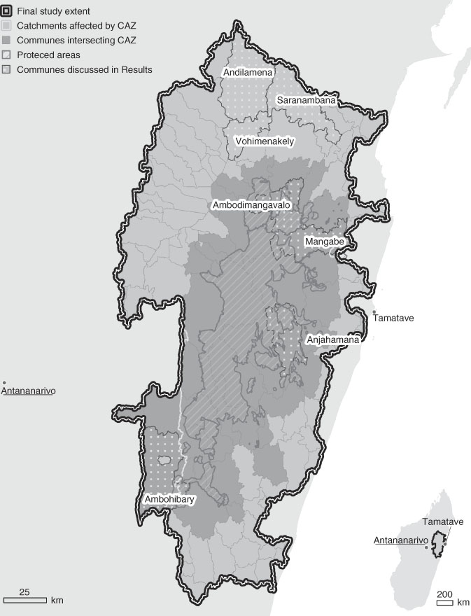
Fig. 1 Map of study area delineation process: specifically, protected areas included, catchments affected by the Ankeniheny–Zahamena Corridor (CAZ), communes intersecting the CAZ and communes discussed in the ‘Results’ section.
Land-Use Scenarios
To identify plausible land-use scenarios and ensure consideration of alternative opinions (Peterson et al. Reference Peterson, Cumming and Carpenter2003), we used participatory processes with a wide range of local stakeholders, policy-makers and scientific experts. We held scenario discussions with members of a multi-institution project focused on whether payments for ecosystem services alleviate poverty (p4ges). We refined these scenarios during a participatory workshop in the CAZ (September 2015) with 28 national, regional and local experts. Participants discussed national policy, focusing on likely large-scale policies that might influence the future CAZ. Local experts (including a local mayor) provided insights about national policies’ influence on local land use. We refined the scenarios with input from over 20 national and international researchers with expertise in Madagascar forest conservation and the p4ges national advisory committee, which included representatives from non-governmental organizations, community associations and the various ministries of environment and forests, research and higher education and planning and decentralization. We also conducted extensive literature reviews to aid the scenario modelling. We identified four likely scenarios from the participatory discussions, workshops and literature reviews. While they may not capture all policy options, they represent the diverse stakeholder consensus for the most feasible and likely policies that will be implemented over the next 10 years:
∙ The business-as-usual (BaU) scenario assumes continued deforestation within the CAZ due to a continuation of the same deforestation drivers. This scenario continues the historical deforestation trajectory. The historical deforestation rate of 1.08% per year (%/yr) was applied over the study area for the entire projection period 2013–2023.
∙ The effective conservation scenario assumes that forested PAs in the study area are effectively conserved in the future, resulting in lower deforestation in these areas than under the BaU scenario; conversely, deforestation will continue in unprotected forested areas in the study area. Sixteen PAs exist in or intersect the study area (Fig. 2), representing a mixture of four well-established PAs, managed by Madagascar National Parks, seven PAs newly designated in May 2015 and five non-forest or forest fragment PAs that were not included in this scenario (Table 1). Ten PAs were included in this scenario: the four well-established PAs (Analamazaotra, Mangerivola, Mantadia and Zahamena) and six of the newly designated PAs; one newly designated non-forest PA was not included. The four well-established PAs experienced lower deforestation during 2005–2010 (0.03%/yr), and we used this to represent effective protection, applying this rate to all ten PAs over the projection period 2013–2023. The six PAs designated in May 2015 had not historically experienced protection and therefore we calculated the historical deforestation for these areas during 2005–2010 (1.16%/yr) and applied this rate to all remaining unprotected forest over the projection period 2013–2023. We restricted the calculation period used in this scenario to 2005–2010 to minimize the impact of the political coup that began in 2009.
∙ The infrastructure development scenario represents the potential deforestation if Madagascar pursues road development. New roads typically increase deforestation, and distance to a road is a major predictor of deforestation (Damania & Wheeler Reference Damania and Wheeler2015). This scenario captures new road construction and improvement (e.g., paving) of another road. During the September 2015 experts’ workshop, there was agreement that improvement to the national highway (RN44) from Moramanga (an important population centre and regional seat) to Ambatondrazaka (the rice bowl of Madagascar) is a regional priority. We also, more controversially, incorporated a new road traversing the CAZ from the capital, Antananarivo, to Tamatave, an important port; a feasibility study of this new road has already been produced (Madagascar Tribune 2016). We included a 15-km buffer along the road, based on the results from Damania and Wheeler (Reference Damania and Wheeler2015), who assessed forest clearing along roads in central Africa, and we assigned a 50% deforestation incentive within the buffer, representing a conservative deforestation incentive. Studies have found a range of deforestation percentages associated with roads and road construction; Barber et al. (Reference Barber, Cochrane, Souza and Laurance2014) found that 95% of deforestation occurs within 5.5 km of a road in the Amazon, and Alves (Reference Alves2002) found that 90% of deforestation occurred within 100 km of roads in the Brazilian Amazon. We implemented the road developments midway (in 2018) through the projection period.
∙ The sustainable agricultural intensification scenario examined the potential impact of intensifying irrigated rice production. Madagascar’s food demand is increasing due to population expansion (Harvey et al. Reference Harvey, Rakotobe, Rao, Dave, Razafimahatratra and Rabarijohn2014) and, although swidden agriculture can be sustainable at low population densities (Brooks et al. Reference Brooks, Holmes, Kramer, Barnett and Keitt2009), it is a driver of deforestation to fallows and eventually degraded land in Madagascar (Styger et al. Reference Styger, Rakotondramasy, Pfeffer, Fernandes and Bates2007). To reduce deforestation and increase the productivity of rice farming, efforts to shift traditional swidden farming to irrigated rice farming are ongoing (Brooks et al. Reference Brooks, Holmes, Kramer, Barnett and Keitt2009) and, while the Madagascar Government has committed to increasing rice production by 300% by 2018 (JICA 2013), it has placed increased emphasis on irrigated rice production with recent investments from the World Bank and other donors. Therefore, this non-spatially explicit scenario assessed the additional yield that could be achieved if a 300% increase in rice production occurred in currently irrigated rice land area, and compared this to the land area needed to achieve the same production increase in rice produced through swidden agriculture.
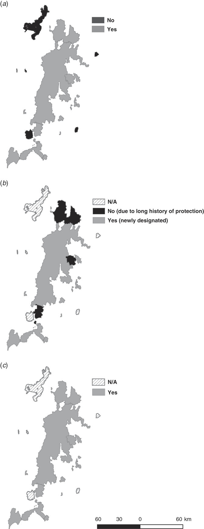
Fig. 2 Protected area assessment included in the effective conservation scenario development: (a) protected areas not included; (b) newly designated protected areas included in the business-as-usual (BAU) rate calculation; and (c) protected areas with effective protection in the future.
Table 1 List of the protected areas located in the study area, whether the protected area was included in the effective conservation scenario and its protection status

Data
Historical Deforestation Data
We used nationally generated, Landsat-based, 30-m resolution multi-temporal deforestation data for 2005–2010–2013 (Rakotomala et al. Reference Rakotomala, Rabenandrasana, Andriambahiny, Rajaonson, Andriamalala and Burren2013) to derive annual historical deforestation in %/yr for the study area. This yielded 0.86%/yr for 2005–2010, 1.5%/yr for 2010–2013 and a combined historical deforestation rate of 1.08%/yr for 2005–2013.
Deforestation Driver Variables and Development of the Predictive Spatial Model
We used an analysis of deforestation drivers conducted in the CAZ as part of the Verified Carbon Standard (VCS)-validated REDD+ project to identify an initial set of spatially explicit deforestation drivers (Conservation International 2013) capturing biophysical characteristics (elevation and slope), accessibility (distance to trails, untarred and tarred roads, rivers, railroads and forest) and agricultural opportunity (distance to regional capitals, the capital city and populated places) (Table 2). We used Cramér’s V statistic to help assess which of the initial variables should be used to create the predictive spatial model for use in the BaU, effective conservation and infrastructure development scenarios. Though not a direct test of significance, Cramér’s V can quickly help indicate the potential explanatory power of variables and the observed historical deforestation; while values greater than 0.15 are considered worthy of further examination, variables with very low Cramér’s V statistics (including distance to the capital city and slope in this study) can be eliminated (Eastman Reference Eastman2016). We then used the Multi-Layer Perceptron (MLP) neural network model in the Land Change Modeler (LCM) package in TerrSet (Eastman Reference Eastman2016) to develop a predictive spatial model using the explanatory variables and the historical deforestation as training data. Multiple modelling options are available in LCM; we used MLP as it is less sensitive than other methods to collinearity among independent variables and non-normal distributions (Eastman & Toledano Reference Eastman and Toledano2018). MLP generates a transition potential surface representing the relative likelihood for a pixel to transition from forest to non-forest. We calibrated the transition potential using observed historical deforestation for 2005–2010 and validated it with the observed historical deforestation for 2010–2013 using a relative operating characteristic (ROC) analysis. The ROC analysis, a standard validation process in change prediction (Pontius & Batchu Reference Pontius and Batchu2003), assessed how well the spatial model predicted the historical change that occurred in the latter period (2010–2013 in our study) based on the historical change that occurred in the earlier period (2005–2010). We used the ROC statistics from multiple MLP runs, the initial Cramer’s V results, the weights generated by MLP and additional model diagnostics, including sensitivity tests, to determine a final set of explanatory variables, which we also compared to the explanatory variables used in several studies implemented at similar scales in other regions (e.g., see Fuller et al. Reference Fuller, Hardiono and Meijaard2011, Sangermano et al. Reference Sangermano, Toldedano and Eastman2012, Reddy et al. Reference Reddy, Singh, Dadhwal, Jha, Rao and Diwakar2017). This final set of nine explanatory variables (see Table 2) was used to generate the final model, which yielded an area under the curve of 0.978.
Table 2 List of driver variables and data sources used in the Land Change Modeler to explore the impacts of different policies on forest cover and deforestation. UTM = Universal Transverse Mercator

We then used the resultant transition potential surface, combined with Markov chain analysis, to determine the amount of land expected to transition in the future under each of the spatially explicit scenarios (BaU, effective conservation and infrastructure development), and generated spatially explicit projection images for a 10-year period, 2013–2023. We assumed a continuation of the same deforestation drivers as the historical period.
We visually inspected the potential deforestation patterns in the projection images and combined the outputs in ArcGIS to compare the spatial distributions of deforestation under the different scenarios. We assessed forest areas that may be conserved under any scenario and forest areas projected to be deforested under any scenario; we also calculated the area of forest cover extent and deforestation by commune at the end of the projection period.
Calculation of CO2 Emissions
To calculate the associated CO2 emissions that would result from projected deforestation under each of the spatially explicit scenarios, we derived aboveground biomass (AGB) estimates for 29 closed-canopy forest plots in the CAZ. Described in Andriamananjara et al. (Reference Andriamananjara, Hewson, Razakamanarivo, Andrisoa, Ranaivoson and Ramboatiana2016), these data capture different elevational gradients (130–1200 m), bioclimate zones and dry season lengths and are located proximal to a range of historical deforestation trajectories. We stratified the study area based on elevation into three zones and used the mean AGB estimate for that area to calculate the associated CO2 emissions from deforestation projected to occur in that area under each policy scenario. The stratification included: (1) a low elevation band along the east extent, ≤700 m, with a mean AGB estimate of 132 t ha–1; (2) a northern band >900 m, with a mean AGB of 101 t ha–1; and (3) a southern area >900 m, with a mean AGB of 71 t ha–1. We performed a qualitative check of the AGB stratification using a satellite-derived, 30-m dataset of aboveground live woody biomass density for 2000 (Zarin et al. Reference Zarin, Harris, Baccini, Aksenov, Hansen and Azevedo-Ramos2016) and a dataset of forest plots in Madagascar including 149 plots in the study area (Vieilledent et al. Reference Vieilledent, Gardi, Grinand, Burren, Andriamanjato and Camara2016). We calculated the total AGB loss associated with the deforestation under each scenario in each stratum. We converted this total AGB loss to carbon content using Chave et al. (2004), and we converted this to CO2 emissions using the standard ratio of 44:12.
Processing of the Sustainable Agricultural Intensification Scenario
For this scenario, we used a modelled, spatially explicit, 1-ha irrigated rice layer, derived from the SimTerra database (Mulligan Reference Mulligan2013a) within the WaterWorld Policy Support System (Mulligan Reference Mulligan2013b). The layer was produced using Landsat Vegetation Continuous Fields (VCF) (Sexton et al. Reference Sexton, Song, Feng, Noojipady, Anand and Huang2013) satellite data to determine per-pixel herbaceous cover, HydroSHEDS (Lehner et al. Reference Lehner, Verdin and Jarvis2008) to determine floodplains and proximity to streams and LandScan (2007) to determine populations. The resulting layer included areas with >70% herbaceous cover, a population >0 and were located on floodplains or streams. Floodplains were modelled as areas within a 10-m elevation of a downstream pixel with Strahler stream order ≥3 and, by combining both floodplains and streams, the layer captured both lowland and hillside irrigated rice. We validated the layer in QGIS using high-resolution imagery (<10 m) from Google Earth (c. 2014) and 100 random sample points distributed equally among irrigated rice and other land. While the overall accuracy was 67% and producer’s and user’s accuracies were 66% and 73%, respectively, this layer represents the best data available for the study area.
We used the layer to calculate the current irrigated rice extent in the study area (309 978 ha) and detailed data (Poudyal et al. Reference Poudyal, Rasoamanana, Andrianantenaina, Mandimbiniaina, Hockley and Razafimanahaka2017) from 375 plots belonging to 170 households distributed throughout the CAZ to calculate the current average productivity for irrigated rice (3052 kg ha–1) and rice produced in the swidden system (1450 kg ha–1). We then estimated the current total production of irrigated rice in the study area (approximately 946 052 856 kg) and calculated the amount of rice that could be produced on the existing rice extent in the study area if a policy were implemented to increase the productivity of irrigated rice by 300% to 9 156 kg ha–1.
Results
During 2005–2013, almost 63 000 ha of forest of global importance were deforested. Deforestation across the study area increased from a rate of 0.86%/yr in 2005–2010 to 1.52%/yr in 2010–2013. Much of the deforestation occurred in three communes: Andilamena and Saranambana in the far north of the study area and Ambohibary in the southwest tip of the CAZ (Fig. 1).
The potential deforestation and associated GHG emissions varied under the different policy scenarios (Fig. 3). Of the 68 241 ha of deforestation projected under a BaU scenario (Table 3), for example, almost 60% occurs in five communes: Andilamena, Saranambana and Vohimenakely in the north, Anjahamana in the east and Ambohibary. Vohimenakely and Anjahamana have not historically experienced high deforestation, but the dense network of unpaved roads in Vohimenakely and the low elevation and relatively dense population in Anjahamena could contribute to the high projected deforestation.
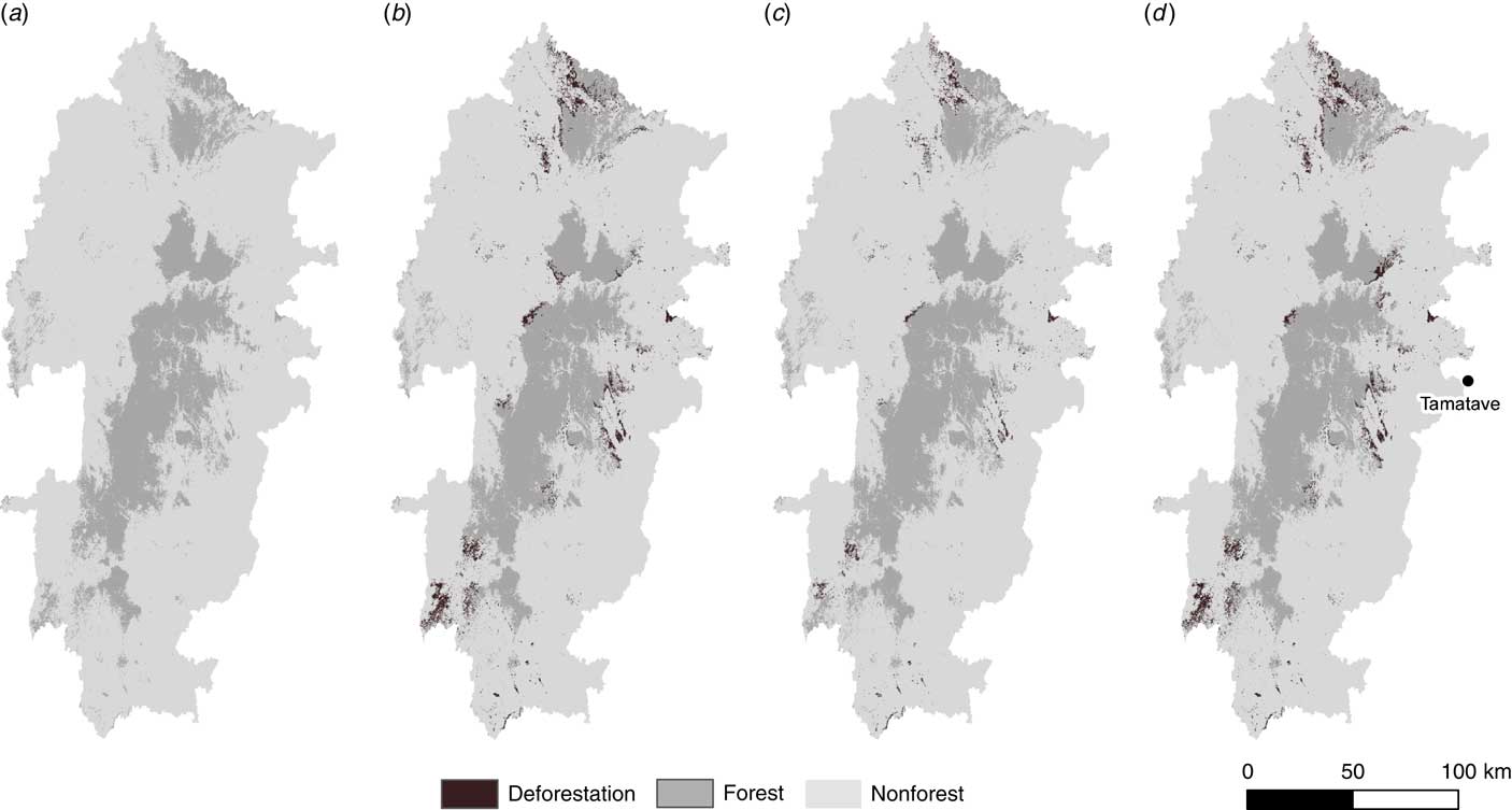
Fig. 3 (a) Forest cover in 2013; and potential deforestation with (b) a business-as-usual scenario; (c) an effective conservation scenario; and (d) an infrastructure development scenario.
Table 3 Comparison of deforestation rates, main communes impacted and associated CO2 emissions from aboveground biomass (AGB) loss from 2013 to 2023 under different policy scenarios

Under an effective conservation scenario, deforestation would be reduced by almost 40 000 ha from a BaU amount of 68 241 ha to 28 860 ha. Of the projected deforestation under the effective conservation scenario, 1100 ha occur within PA boundaries, including Mangabe in Ambohibary commune and the isolated CAZ forest in Anjahamana commune. These two areas account for the majority of the projected deforestation of 0.03%/yr, explicable by the high deforestation rate experienced in the area around Mangabe prior to protection and the strength of the deforestation drivers in these two areas. The remaining 27 760 ha of projected deforestation occurs in areas of unprotected forest outside the effectively conserved PAs, mostly in the northern commune of Andilamena.
Under the infrastructure development scenario, the 68 241 ha of projected deforestation expands to the north of the study area, because of the new road proposed from Antananarivo to Tamatave. The new road would greatly increase pressure in the Zahamena PA, a World Heritage Site.
Our analysis highlights areas vulnerable to deforestation under the three scenarios of BaU, effective conservation and infrastructure development, in which the communes of Andilamena, Ambohibary, Anjahamana and Vohimenakely capture over 60% of the projected deforestation. Conversely, the communes of Ambodimangavalo, Mangabe, Ambohibary, Saranambana and Didy only account for significant deforestation in a single scenario. For example, forest in Ambodimangavalo and Mangabe communes is only threatened under the infrastructure scenario. Most of the projected deforestation in Didy commune occurs only under a BaU scenario. In addition, while both Ambohibary and Saranambana communes are projected to experience deforestation under multiple scenarios, some portions of these communes are only projected to be deforested under the BaU scenario.
The three spatially explicit scenarios have different impacts on AGB, carbon and associated CO2 emissions (Table 3). Under a BaU scenario, 12 928 101 tCO2 would be emitted. In contrast, under an effective conservation scenario, substantially less would be emitted: 5 547 600 tCO2, 60% less than the BaU scenario. The effective conservation scenario results in 7 000 000 tCO2 emissions being avoided compared to the BaU scenario. Under the infrastructure development scenario, 13 108 608 tCO2 would be emitted. Higher CO2 emissions are projected under an infrastructure development scenario compared to the BaU scenario because of the higher AGB content of the forest that would be deforested by the construction of the new road.
The sustainable agricultural intensification scenario highlights the significant reduction in pressure on forests that may be achieved by increasing productivity in existing irrigated rice areas; 2 838 158 568 kg of rice could be produced on the existing rice areas in the study area (309 978 ha) with a policy aimed at increasing productivity by 300%. Conversely, tripling rice production using swidden agriculture would require almost six times more land (1 956 895 ha) and result in significant deforestation. Our results suggest that an increase in productivity on existing rice areas could reduce deforestation. As we assumed that areas suitable for irrigated rice have already been cleared, increased productivity would not lead to more land clearance.
Discussion
Our analysis is an important case study of how expert-derived policy scenarios can be converted into spatially explicit land change models and used in land-use policy development. It shows how scenario modelling supports decision-making in various ways. First, scenario modelling informs different strategic options at the national level by comparing the relative impacts of different policy options. In the CAZ, for example, increased pressure around a PA of global significance may be used to argue against road construction. The evidence of the emissions reductions from effective conservation can help solicit international investment to help Madagascar reach its Nationally Determined Contributions (NDCs). Secondly, scenario modelling provides insight into the finer-scale implications of a selected option, enabling land managers to more efficiently plan for and address projected deforestation by effectively targeting extra protection. The modelling of potential future road construction can also show where deforestation from construction could occur, allowing policy-makers to target conservation efforts to these areas. Thirdly, scenario modelling can help identify areas facing such high threats of deforestation (regardless of what policy is implemented) where only triage may be appropriate and targeting investment to lower-risk areas may be more effective. Fourthly, the scenario modelling development process can provide additional insight into historical deforestation patterns. For example, the increase in deforestation during the 2010–2013 period in the CAZ potentially reflected both the political turmoil between 2009 and 2014, which adversely influenced forest governance (Anonymous 2018), as well as the illegal mining for sapphires and other precious stones, which represents an increasing driver of deforestation in the CAZ (Jones Reference Jones2016). Finally, the examination of multiple scenarios facilitates assessments of policy implications on ecosystem services linked to forest cover (such as freshwater provision or erosion avoidance), further improving policy design.
Caveats exist concerning the use of such modelling and its interpretation. The value of the scenarios depends on how well grounded they are in likely future policy, and the projections, while revealing potentially useful information, represent only one plausible outcome of many (Pontius et al. Reference Pontius, Boersma, Castella, Clarke, de Nijs and Dietzel2008, Aguiar et al. Reference Aguiar, Vieira, Assis, Dalla‐Nora, Toledo and Santos‐Junior2016). While we selected broad scenarios based on support and interest from stakeholders (which has been shown to improve the rigour of scenarios; Peterson et al. Reference Peterson, Cumming and Carpenter2003), the development of the scenarios depended on available information. For example, while there may be multiple infrastructure proposals under discussion, it is difficult to anticipate which will find viable funding. Further, we implemented the land change modelling using deforestation drivers for which we had geographic data. Other factors that impact deforestation, such as mining and weak enforcement by forest service employees (Raik, Reference Raik2007), could not be incorporated due to data limitations.
Important additional caveats also exist in our agricultural intensification scenario. Given that most rice farming in rural Madagascar uses traditional practices with relatively low yields per hectare (Minten et al. Reference Minten and Barrett2008), major increases in irrigated rice productivity such as those modelled may be possible (Rodenburg et al. Reference Rodenburg, Zwart, Kiepe, Narteh, Dogbe and Wopereis2014), but are not assured (Tsujimoto et al. Reference Tsujimoto, Horie, Randriamihary, Shiraiwa and Homma2009). It may be unrealistic that such increases, even if achieved, would completely displace rice produced by swidden agriculture, partly because of patterns of land ownership (Poudyal et al. Reference Poudyal, Ramamonjisoa, Hockley, Rakotonarivo, Gibbons and Mandimbiniaina2016). People are also unlikely to cease swidden agriculture if it remains profitable despite increases in productivity elsewhere. Finally, while we did not generate emissions associated with the agricultural intensification scenario, we recognize that irrigated rice also emits methane, an important GHG; though these emissions can be effectively reduced through water regime control (Rakotovao et al. Reference Rakotovao, Razafimbelo, Rakotosamimanana, Randrianasolo, Randriamalala and Albrecht2017), this would need accounting for in intensification. While multiple assumptions underlie this scenario, and it differs from the other scenarios as no spatial modelling was performed, because rice production intensification is a focus of the Madagascar Government, this scenario still provides useful insight into how investment in land already in cultivation may take further pressure off remaining forest areas.
Madagascar faces many challenging decisions. Its 25 million citizens demand rapid development to alleviate poverty, improve food security and improve human well-being (Harvey et al. Reference Harvey, Rakotobe, Rao, Dave, Razafimahatratra and Rabarijohn2014). Agricultural production must be increased to improve food security and meet the needs of a rapidly growing population. Improved infrastructure is needed to facilitate the movement of goods and people and enhance economic development. However, at the same time, Madagascar aims to conserve its remaining forests and reduce emissions from deforestation (Panfil et al. in review).
While this study focused on land change modelling for informing decisions in Madagascar, other countries with similar forest conservation policies and development challenges could also benefit. Our analysis has shown that the use of satellite-derived information, land change modelling and scenario analyses can help policy-makers better understand the implications of different agricultural, development and conservation policies on forest cover and associated GHG emissions, and facilitate informed decisions.
Financial Support
This work was funded by the ESPA programme as part of the p4ges project (grant references: NE/K008692/1, NE/K010115/1 and NE/K010220-1). Permission was granted by the Ministry of Environment, Ecology, Sea and Forest for the collection of the aboveground biomass data (N _147/14/MEF/SG/DGF/DCB.SAP/SCB).
Conflict of Interest
None.
Ethical Standards
None.
Acknowledgements
We thank B Ramamonjisoa, P Ranjatson, L Andriamaro, J Randrianarisoa, A Cameron, I vanMeerveld and the entire p4ges team: those who attended the stakeholder workshop and those who have since advised (H Andrianandrasana, A Razafimpahanana, JR Rakotorijaona, C Ramiarison, V Rabetokotany, R Ranaivoarison, JN Ndriamiary and A Mamitiana). We also thank H Tien and K Koenig for the illustrations.


 Open access