


At a meeting of the Royal Archaeological Institute in London on 7 February 1867 an object was exhibited for discussion. It was a fragment of perforated clay ‘plaque’, discovered the previous year during gravel-digging at Coombe Warren, Kingston Hill, Surrey. It attracted considerable attention, but its function ‘appeared very doubtful; and no satisfactory suggestion was offered at the meeting’ (Tregellas Reference Tregellas1868, 155). During the following century occasional finds of similar objects were made in south-eastern England. They were eventually recognised as an artefact specific to the Late Bronze Age of the middle and lower Thames valley (Champion Reference Champion1980, 237–8 & figs 8–9); though various suggestions had been made, none was persuasive and their function still appeared ‘very doubtful’. Since then there has been a rapid increase in the rate of discovery, as a result of the amount of excavation in advance of development in the area. Finds are now known from more than 70 sites (Table 1) and it is possible to reassess their chronology and distribution, as well as to suggest a social context and a possible function.
Table 1 Sites with perforated clay plates
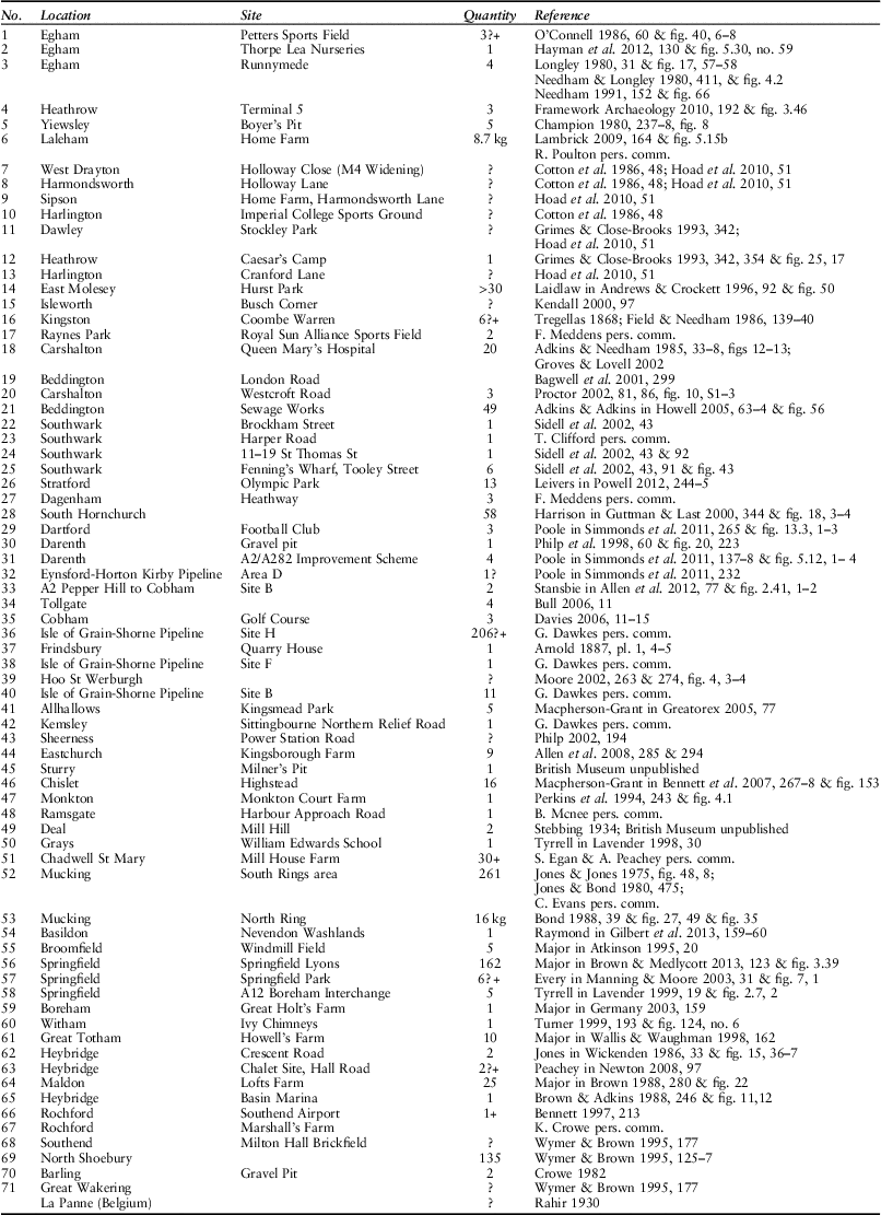
Sites are listed in approximately west to east order as far as east London, then sites south of the Thames followed by those north of the river. Quantities are in numbers of fragments, except for Home Farm, Laleham, and Mucking North Ring, which are by weight. Site numbers correspond with those in Figure 2.
Information for the present study has been gathered through a variety of methods over a considerable period of time. The original article (Champion Reference Champion1980), followed especially by the detailed publication of some key assemblages such as the finds from Queen Mary’s Hospital, Carshalton (Adkins & Needham Reference Adkins and Needham1985) and Mucking North Ring (Bond Reference Bond1988), drew attention to these artefacts and greatly increased the chances of their correct identification and publication. Monitoring of published excavation reports from the region therefore provided the first line of new information. Subsequent enquiries to county archaeologists and museum curators produced further information, often with reference to recent or even current excavations. Finally, enquiries to the commercial companies carrying out the excavations were answered with details of the discoveries, and often, very generously, with details about further sites as yet unknown to the author. More than half the sites now known have been excavated since 1990. No systematic trawl of the very extensive grey literature has been undertaken, and the list of sites in Table 1 makes no claim to being exhaustive.
These items have often been referred to as ‘plaques’, following the original terminology of 1868, but also as ‘slabs’, ‘tablets’, or ‘tiles’. The term adopted here is ‘plates’, in line with a recent suggestion (Poole in Simmonds et al. Reference Simmonds, Wenban-Smith, Bates, Powell, Sykes, Devaney, Stansbie and Score2011, 138 & 265), more in keeping with modern practice and following the established terminology of ‘oven plates’ for somewhat similar objects from other periods. Detailed references for the finds are given in Table 1, and these will not be repeated in the text, unless required for some specific point.
Form
There are fewer than ten examples that are complete or nearly complete, compared to many hundreds of fragments, but they are enough to demonstrate the characteristic features of this artefact type (Fig. 1). Most examples are found as small fragments with sufficient of the features of shape and perforation surviving to allow their correct identification; even very small fragments with evidence of characteristic features may be identified with some confidence, as at Crescent Road, Heybridge, or Thorpe Lea Nurseries, Egham, but it is possible that other small fragments without such clear evidence have been recovered but gone unrecognised among other assemblages of pottery or fired clay. Though varying somewhat in size, the vast majority of the known examples exhibit a marked similarity in form.

Fig. 1 Perforated plates from (top left) Queen Mary’s Hospital, Carshalton (after Adkins & Needham Reference Adkins and Needham1985, fig. 12); (top right) Caesar’s Camp, Heathrow (after Grimes & Close-Brooks Reference Grimes and Close-Brooks1993, fig. 25, 17, fig. 25, 17); (bottom left) Mucking North Ring (after Bond Reference Bond1988, fig. 27, 1); (bottom right) Yiewsley (after Champion Reference Champion1980, fig. 8)
The plates are roughly rectangular in shape; corners are sometimes sharply defined, but more often slightly rounded. A small number of fragments have a more oval shape; this form seems to dominate the assemblage from Queen Mary’s Hospital, Carshalton, though other examples are known from Home Farm, Laleham, Heathrow Terminal 5, and the Darenth A2/A282 Improvement Scheme. Although most examples, where the full form can be reconstructed, show straight or slightly convex sides, some of the examples from Queen Mary’s Hospital, Carshalton, show a semi-circular notch in the centre of one of the short sides, a feature known also in one example from the A2/A282 Improvement Scheme at Darenth in Kent. Its function is obscure, but may have been to fix the plate firmly in place in some larger structure.
The smallest known example is one from Yiewsley, measuring 145×135 mm; two others from the same site are slightly larger, at 150×145 mm. The largest known are from Queen Mary’s Hospital, Carshalton, where two nearly complete examples measure approximately 220×190 mm. Other near-complete examples from Mucking North Ring, North Shoebury, and Dagenham Heathway fall within these limits, with roughly the same proportions. A complete example found at Frindsbury, Kent, in the 19th century was illustrated without a scale. The plates vary in thickness from about 15 mm to 30 mm, but the vast majority are about 20 mm thick. The edges are in general roughly rounded, although some examples show a more clearly defined profile, with a squared or sloping edge. Some pieces show a groove along one edge, discussed further below.
The plates are perforated by a number of roughly circular holes, formed by an implement such as a stick before firing, though it is also suggested that some may have been formed round a circular core; diameters are in the range 13–40 mm, but typically 15–20 mm. The perforations are usually formed from one side, creating a ridge around the hole on the other side of the plate, though this is sometimes smoothed off. The pattern of perforations can only be discerned on the more complete examples. Some are regularly geometric: examples similar to the arrangements on modern dice are known for four (Frindsbury and Queen Mary’s Hospital, Carshalton), five (Yiewsley), and six (North Shoebury) holes. One of the plates from Yiewsley showed seven holes, in two rows of three with one central; at Caesar’s Camp, Heathrow, an incomplete example showed a row of two and a row of three holes and, if symmetrical, would have had another row of two; the original object from Kingston Hill shows eight perforations, in two rows of four. The fragment from Heybridge Marina shows at least ten perforations. Other examples seem to have a more irregular pattern of perforations, as at Queen Mary’s Hospital, Carshalton, perhaps correlated with the more rounded shape of the complete plate. As the number of perforations increased, so the plates became more fragile. Mean fragment weight, where figures are available, tends to be in the range 40–50 g.
There are few signs of manufacturing technique, other than the smoothing of the perforation ridges mentioned above. Some fragments show signs of finger-tip impressions and most of the plates seem to have been formed simply by hand, though one example from Queen Mary’s Hospital, Carshalton, shows signs of having been shaped by a knife. The plates appear to have been roughly shaped from a ball of clay; some are clearly thinner at the centre and thicker around the edges, as though formed by pressure from the centre. One example from Mucking North Ring shows impressions of wattle-work on one surface; this seems most likely to be the result of the surface on which the plate was formed rather than a structural fixing. Some examples are more carefully finished: fragments from North Shoebury are characterised by one surface (the ‘top’) being slurried to produce a smoother finish, while the other surface (the ‘bottom’) was profusely gritted, a feature also noted at Queen Mary’s Hospital and Westcroft Road, Carshalton; this feature recalls the heavily gritted exterior surfaces seen on the bases of some pots in the Late Bronze Age and Early Iron Age.
One recurring feature of the plates is the presence of a more or less pronounced groove along one or more edges, usually along one of the long sides; at Queen Mary’s Hospital, Carshalton, and Mucking North Ring the groove occurs in the short side. This may have been a functional trait, perhaps allowing the plates to be fixed into some larger structure or enabling them to be used in multiples, rather like modern tongue-and-groove boarding, to form a larger area, although the more rounded shape of some examples might make this unlikely. Alternatively, it may be a product of their manufacture, perhaps being formed against a framework of rods to shape one or more sides of the object; or again, it may have resulted accidentally from the plate’s being flattened on one side and then turned and flattened on the other.
Apart from these variations in general shape, presence and location of the edge groove, presence or absence of a notch, and the number of perforations, there are few other variants to the standard form. One fragment from Westcroft Road, Carshalton, has been interpreted as the end of a narrow bar with a single row of perforations. Another fragmentary example from Dartford Football Club has been reconstructed as part of a small strip with two perforations, though it might possibly be the corner part of a larger plate with a notch.
Fabric and use-wear
The plates are generally made from a fabric with a sandy matrix and a tempering of crushed flint, occasionally incorporating other temper, and very often indistinguishable from a fabric used for pottery at the same site. The flint is often finely crushed, though examples with much coarser flint grains are known; quantities are mostly sparse, though again examples with much denser quantities are known. The only other fabric used was one with a similar sandy matrix and a vegetable temper. This was particularly common in Essex, at sites around Chelmsford and also at Mucking North Ring on the Thames Estuary, but is also found occasionally elsewhere.
The fragmentary nature of many of the finds has undoubtedly made their detailed study more difficult, but it is noticeable how few comments there are on any visible signs of use-wear by the various specialists who have studied and published these objects. In the original publication of the plates from Queen Mary’s Hospital, Carshalton, Robarts (Reference Robarts1905, 394 & 6) described them as ‘all very much burnt’ and ‘very thoroughly burnt’, although it is not clear whether he was referring to evidence of manufacture or of use. Elsewhere, there are only very occasional mentions of signs of burning: at Mucking North Ring it was specifically noted that few of the many examples were burnt (Bond Reference Bond1988, 39), while the lack of signs of burning was also remarked at Caesar’s Camp, Heathrow, and other sites (Grimes and Close-Brooks Reference Grimes and Close-Brooks1993, 354) and also at Home Farm, Laleham; at Hurst Park, East Molesey, it was reported that none of the fragments showed signs of having been exposed to high temperatures (Laidlaw in Andrews & Crockett Reference Andrews and Crockett1996, 92). Visual inspection of plate fragments from a number of other sites by the author suggests that few, if any, examples show signs of wear, discolouration or encrustation that might arise from use rather than from manufacture or post-depositional processes. The evidence, if broadly consistent, is anecdotal rather than systematic, and the question would be worth further research, perhaps through the analysis of a large collection from a single site in direct comparison with the contemporary pottery assemblage.
Distribution
The distribution of the plates is shown in Figure 2. They are, with a few exceptions, confined to the middle and lower Thames valley below Runnymede and show a markedly riverine and coastal distribution along the Thames and its estuary, and in the valleys of some of its tributaries such as the Wandle and the Lea. There are also finds from two regions lying respectively to the north and south of the mouth of the Thames, both of which are themselves riverine. One of these consists of clusters of sites around the estuary and lower valley of the River Backwater at Heybridge, Essex, and in the valley of its tributary River Chelmer, near Chelmsford. The other is a group of sites in east Kent, around the River Stour and the Wantsum channel, stretching as far south as Deal. The most distant findspot is at La Panne (De Panne), a coastal site in Belgium very near the French border.
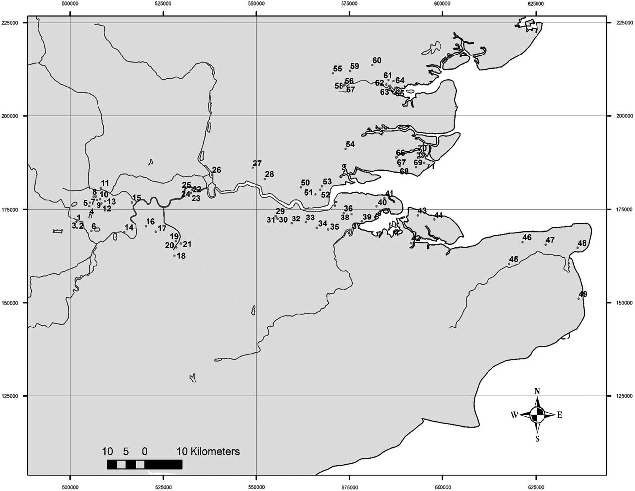
Fig. 2 Distribution of sites with perforated clay plate fragments, numbered as in Table 1 (La Panne, Belgium, not mapped)
Two sites further upstream in Berkshire, at Moulsford and Pingewood, were wrongly included in an early attempt to map the distribution (Champion Reference Champion1980, fig. 9); this was based on misunderstanding by the author, and further information, including publication (Johnston 1983–Reference Johnston5), has now made it clear that there were no finds of this type at these sites, which should therefore be removed. There is also a possible additional example of this type of plate from Reading Business Park: this small fragment of fired clay with a perforation was originally published as a fragment of a loomweight (Bradley & Hall in Moore & Jennings Reference Moore and Jennings1992, 87 & fig. 52, 1), but subsequently reinterpreted as a possible perforated plate fragment (Barclay in Brossler et al. Reference Brossler, Early and Allen2004, 94), together with a further possible plate rim fragment.
Within this zone, the distribution of plates is somewhat uneven. The number of fragments found on each site varies considerably, and this will be discussed further below. At a larger scale, the plates are most common in southern Essex and northern Kent, where several of the largest assemblages occur. They are less frequent further west, and, despite many findspots, there are only two sites with large assemblages west of central London.
Chronology
Some of the older finds understandably have very limited contextual information and hence cannot be reliably dated. Thus, Frindsbury, Yiewsley, and Coombe Warren, Kingston, for example, all have vague Late Bronze Age associations, but no certain contexts; finds from early excavations at Queen Mary’s Hospital, Carshalton and Mill Hill, Deal, certainly belong in the final stages of the Bronze Age, though greater precision is impossible. Contextual evidence improves with examples that have come from more recent excavations. There are no finds from contexts with classic Deverel-Rimbury associations or dates. Perhaps the earliest suggested example is that from Thorpe Lea Nurseries, Egham, found in a pit with a small assemblage of pottery and assigned to the Middle Bronze Age on the grounds of that association and its location near other, more securely dated features. This comparatively weak evidence for a Middle Bronze Age beginning is in contrast to many other sites which have firm associations with pottery which can be assigned to the Post-Deverel-Rimbury plainware phase of the Late Bronze Age, between 1100 and 800 bc (Barrett Reference Barrett1980; Needham Reference Needham2007). These include Runnymede and Petters Sports Field, Egham; Caesar’s Camp and Terminal 5, Heathrow; the Southwark sites; Olympic Park; and Tollgate, Cobham Golf Course, the Isle of Grain–Shorne Pipeline sites, Hoo St Werburgh, the Dartford Football Club site, and the A2/A282 Improvement Scheme, Darenth, all in Kent; and Springfield Lyons in Essex. At South Hornchurch, the plates are found in contexts dating to Phases 2 and 3 of the site sequence, which extends from the plainware phase into the succeeding decorated ceramic phase, equivalent to the earliest Iron Age. At Monkton and Highstead the ceramic associations would again suggest the possibility of a date in the decorated phase.
There are no clear associations with pottery of the Early Iron Age. The example from Ivy Chimneys, Witham, Essex, came from a disturbed context; although no Late Bronze Age phase was recognised at the site, where the main occupation began in the Middle Iron Age, it is possible that there had been an earlier phase of activity with artefacts redeposited in later contexts. The finds from La Panne in Belgium came from early excavations and are without secure context; reappraisal of the site suggests that, although activity may have started in the earliest phase of the Iron Age, the bulk of the ceramic and metalwork evidence is consistent with a date from Early La Tène onwards (Kerger Reference Kerger1999).
The plates can therefore be most securely dated to the final phase of the Bronze Age and the very beginning of the Iron Age. How early they started is not yet clear. It is possible that they continued throughout the plainware ceramic phase and somewhat later, thus spanning a period of perhaps 1100–700 bc; the main period of their use may also have been much shorter, towards the end of this phase.
Late bronze age context
The distribution of the plates merits further discussion to place them in their Late Bronze Age context. It is strongly correlated with the density of evidence for field systems of the later Bronze Age and the patterns of deposition of metalwork. The correlation between the distribution of fields and metal has already been discussed by Yates (Reference Yates2007, 112–20). In Kent, the distribution of the plates closely matches the pattern of fields and bronzes in the north of the county: this is concentrated around the Isle of Thanet and the Wantsum in the north-east and in the Isle of Sheppey, around the Medway, and the Hoo peninsula in the north-west. In Essex there are notable concentrations of evidence for fields and bronze deposits around the Blackwater and in the area around Southend, both matched by finds of plates (ibid., 73–7).
The valleys of two tributaries of the Thames are also conspicuous for their concentrations of metalwork and land division, the River Lea (ibid., 114 & fig. 12.4) to the north and the River Wandle, especially its upper reaches, to the south (ibid., 114 & fig. 12.5). The Lea valley has so far only produced a single findspot of plate fragments at the Olympic Park site, but to the south there is a cluster of sites in the upper Wandle valley around Queen Mary’s Hospital, an area notable for its unusual deposits in addition to the metalwork (Proctor Reference Proctor2002).
There is much less evidence for fields in central London, possibly because of the more restricted nature and scale of excavations, but the findspots of plates in Southwark correspond to a notable cluster of sites with evidence for Bronze Age activity including cultivation (Yates Reference Yates2007, 32); they are also close to a concentration of bronze objects from the Thames and more especially from sites on the north bank: ‘what is eye-catching is the great cluster of land finds that has appeared in the area of the City’ (Needham & Burgess Reference Needham and Burgess1980, 455).
There are a number of further sites, albeit mostly with a comparatively low density of plate fragments, on the western outskirts of London, from Kingston to Egham, many of them within the large area of fields found on the west London gravel terraces (Yates Reference Yates2007, 32–6), such as those at Heathrow Terminal 5 and neighbouring sites.
These geographical patterns of Late Bronze Age activity have mostly been revealed by modern development-funded archaeology, and are therefore influenced by modern social and economic factors as well as past reality. To what extent the blank areas were really unoccupied, or only minimally exploited, at that time is still uncertain. Yates’s methodology was designed to include fieldwork reports where no Bronze Age features were identified, thus suggesting genuinely blank areas, but there are other parts of the lower Thames valley where comparatively little fieldwork has taken place because of the nature of modern land-use and development, for example in the suburban and parkland areas of much of south-western London.
Within this lower Thames region, however, the distribution is not even, and there is considerable variation in the number of plates or fragments found at each site. Quantitative comparison by site is clearly problematic as numbers will be determined by many factors such as post-depositional history, scale of excavation, recovery strategy, and recognition in post-excavation processing, as well as original usage and deposition. Nevertheless, there are striking variations in quantities of plates recovered. Most sites have produced fewer than ten fragments; only 13 sites have produced more than 15 fragments. In seven cases these are known Late Bronze Age defended enclosures or ringworks, the type of site that Yates (Reference Yates2007, 18) has called ‘aggrandised enclosures’: Springfield Lyons, Lofts Farm, Mucking North Ring and South Rings, South Hornchurch, Highstead, and Queen Mary’s Hospital, Carshalton. The exceptions are North Shoebury, where 133 fragments were recorded in rescue excavations, and where the nature of the Late Bronze Age occupation was uncertain; Chadwell St Mary; the Beddington Sewage Works site near Queen Mary’s Hospital, Carshalton; and Hurst Park, East Molesey, Surrey. There are also two sites, Home Farm, Laleham, and Isle of Grain–Shorne Pipeline Site H, where quantities have been affected by the discovery of large concentrations in specific contexts. It is possible that the aggrandised enclosures have attracted a larger scale of excavation than some of the smaller sites, thus affecting the quantity of finds, or that large deposits have been missed in small-scale excavations, but it is noticeable that even extensive areas of Late Bronze Age landscape have produced few examples, such as the 47 ha examined at Heathrow Terminal 5, which produced only three fragments. It is quite possible, therefore, that the apparent concentration of finds on such exceptional sites is a real association and a reflection of the density or frequency of the activity that produced and used them. This suggested correlation with defended enclosures will be discussed further below.
Function
Since the original discussion of these objects in 1867, the question of their function has been dominant, but not satisfactorily resolved. Authors have seen them as objects with a mechanical or technological function, and no suggestions have been made about possible ornamental or symbolic uses or other non-utilitarian values. In view of the basic materials used, the simple technology of production, their lack of decoration, and fragile nature, and (at least to modern eyes) their comparatively unprepossessing nature and appearance, this may not be unreasonable. Though individual objects may have been invested with particular significance, it seems likely that his would have been derived from the social context of use. In the following discussion, the concept of their function is therefore viewed in a strictly utilitarian fashion.
The plates are clearly different from other types of perforated object sometimes found in later prehistoric assemblages. They are flat plates rather than vessels, and therefore unlike the pottery bowls with perforated bases known from Iron Age contexts, where the perforations are, in any case, generally somewhat smaller. Perforated plates were also used for tablet weaving. They are not common finds in Britain (Cunliffe Reference Cunliffe2005, 487 & fig. 18.1, 24), but are known more widely in western Europe (eg, Grömer Reference Grömer2010, 107–12), most frequently in bone but occasionally in fired clay (eg, Castillo Rollán Reference Castillo Rollán1996). They differ from the plates under consideration here, however, in a number of ways: in size and weight, being generally much smaller, thinner and lighter; in shape, being regularly symmetrical, typically triangular or square, rarely rectangular; and in the location of the perforations, which are few in number and placed near the edges or vertices of the tablet and perhaps centrally.
A number of different functions have been suggested for these plates: Robarts (Reference Robarts1905, 394) suggested use in a ‘movable kiln for pottery making’ or alternatively that they ‘may have been used when cooking’; other suggestions have included ‘some kind of ventilator’ (VCH Middlesex, I, 57, fn 98), ‘primitive hotplates’ (Jones & Jones Reference Jones and Jones1975, 141), use in controlling a bonfire for firing pottery (Adkins & Needham Reference Adkins and Needham1985) or in metal-working (Perkins et al. Reference Perkins, Macpherson-Grant and Healey1994), or as a part of an oven or furnace, whether for firing pottery (Rahir Reference Rahir1930) or for cooking food (Bradley Reference Bradley2007, 210), more specifically for baking (Andrews & Crockett Reference Andrews and Crockett1996, 101), or as part of the process of making salt (Riehm Reference Riehm1962, 387; Jones & Bond Reference Jones and Bond1980, 475; Kerger Reference Kerger1999), or in a multifunctional kiln (Poole in Simmonds et al. Reference Simmonds, Wenban-Smith, Bates, Powell, Sykes, Devaney, Stansbie and Score2011, 265). Two authors have suggested and illustrated quite specific uses: Perkins has argued for their use to improve air supply in metal-working furnaces for melting bronze (Perkins et al. Reference Perkins, Macpherson-Grant and Healey1994, 311–2 & fig. 33), while Rahir reconstructed a perforated plate with pedestals inserted into the perforations to support a vessel during pottery firing (1930, fig. 7).There is general agreement that the plates were meant to allow the passage of air for some purpose, rather like modern air bricks; the holes are much larger than those used for liquids, as in modern strainers and colanders. A more precise interpretation of their function or functions will depend on additional evidence, such as discovery in a primary structural context; fabric and use-wear; distribution; depositional contexts and associations; and typological and technological parallels. Since no example of a plate has yet been found in a structural or functional context clearly showing its method of use, the first of these lines of argument can be quickly dismissed. The evidence for fabric and use-wear has been described above, where it was suggested that few, if any, of the objects bear significant marks derived from usage.
The estuarine distribution of the plates might suggest a connection with the salt-working industry, which can be documented in the Late Bronze Age at relevant sites in the Thames estuary such as Mucking (Barford Reference Barford1990). Plates and salt briquetage are found at North Shoebury, Mucking North Ring, South Hornchurch, Highstead, Isle of Grain–Shorne Pipeline sites, Hoo St Werburgh, Cobham Golf Course, Northfleet, and at La Panne in Belgium. Nevertheless, it seems unlikely that there was a functional relationship between the plates and salt production, for two major reasons. First, much of the fired clay used in salt production has a characteristic dark red, purple, or even lavender surface colour, sometimes with a white or cream encrustation. None of the plate fragments so far inspected shows any sign of these features. Secondly, some of the sites producing plates are too far from the salt water of the estuary to have been realistically the location of salt production. It is true that at Mucking at least some stages of the salt production, or the production of fired clay artefacts for use in this process, took place some distance inland and uphill from the water’s edge (Jones Reference Jones1977), and the same phenomenon has been noted for some of the HS1 sites in Kent (Booth et al. Reference Booth, Champion, Foreman, Garwood, Glass, Munby and Reynolds2011, 216–7), but these distances are small compared to the distances between some of the other sites producing plates and the contemporaneous existence of salt water. Modern perceptions of the Thames separate a marine zone (ie, salt content above 30 parts per thousand) from a brackish one (salt content in the range 0.5–30 parts per thousand) at around Dartford, with freshwater conditions above Battersea. Even allowing for variations in salinity in prehistory, it seems highly improbable that the Surrey and west London sites from Kingston to Egham would have been within suitable distance of salt water; remains of prehistoric salt-working have not been reported higher up the Thames estuary than at South Hornchurch (Guttman & Last Reference Guttman and Last2000, 344 & fig. 18.2). A third reason may also be offered from an analysis of the more specific contextual locations and associations at Mucking North Ring, where it was noted that ‘there was little correlation between the distribution of this material and the debris of salt manufacture’ (Barford in Bond Reference Bond1988, 50) A role in salt-working can therefore be excluded.
Another recurring association is with metal-working, as at Springfield Lyons (Needham & Bridgford in Brown & Medlycott Reference Brown and Medlycott2013, 47–74), Mucking North Ring (Bond Reference Bond1988, 21–2 & fig. 14), South Hornchurch (Guttman & Last Reference Guttman and Last2000, 344 & fig. 19), Mill Hill, Deal (Champion Reference Champion1980, 237 & fig. 5.6), and Highstead (Bennett et al. Reference Bennett, Macpherson-Grant and Couldrey2007, 258–65 & figs 148–51). Whether they would have been used in the smelting of copper or, more probably, in the heating of crucibles to melt the bronze alloy, it seems likely that the temperatures necessary would have caused far more surface modification to the plates than has been evidenced anywhere. The recurring comments on the comparative lack of the expected marks of burning seem to rule out their use in such processes. Nor has any fragment yet been claimed to exhibit surface traces of metal droplets. The associations with metalworking seem mainly restricted to some of the aggrandised enclosures, and it is noticeable that other sites, such as Heathrow Terminal 5, have produced no evidence of metalworking, despite extensive excavation.
The same argument about temperature would also probably rule out any role in the production and firing of pottery. Structures incorporating perforated clay plates have been claimed as pottery kilns in other parts of western Europe in the Late Bronze Age (eg, Audouze & Büchsenschütz Reference Audouze and Büchsenschütz1991, 138–9). If this interpretation is correct, they seem somewhat larger than the plates being considered here; the example from Sévrier, Haute Savoie, France, was 0.6 m in diameter. It is true that we do not know the full size or form of the structure into which the plates were fitted, but they still seem rather small for elements of pottery kilns. In any case, with the benefit of more recent research we can rule out Rahir’s suggested reconstruction of their use as supports in a kiln at La Panne (1930, 21 & fig. 7). The pedestals he shows inserted into the perforations of a plate, as well as other items of fired clay, would now be recognised as components of salt-working briquetage (Kerger Reference Kerger1999, 78), well documented in northern France (Prilaux Reference Prilaux2000, 74–7) as well as southern (eg, at Mucking North Ring; Barford in Bond Reference Bond1988, 39–41) and eastern England (Lane & Morris Reference Lane and Morris2001, 370–2; Morris Reference Morris2007, 430–2). Salt was clearly being extracted from sea-water at La Panne, as at sites in the Thames estuary, but not with a technology incorporating perforated plates.
A recurring association of the plate fragments is with burnt material. At Queen Mary’s Hospital, Carshalton, Robarts noted that they were found with deposits he interpreted variously as hearths (1905–6, 149) or as cremation deposits (1905, 397). More recent excavation reports have been more specific. At the A2/A282 Improvement Scheme fragments of perforated plates were found in a pit with a charcoal-rich fill and in a hollow containing a large deposit of burnt flint, possibly the remains of a redeposited burnt mound (Simmonds et al. Reference Simmonds, Wenban-Smith, Bates, Powell, Sykes, Devaney, Stansbie and Score2011, 69 & 137). At the Dartford Football Club they were found with carbonised seeds and grain and burnt bone, as well as fired clay interpreted as structural oven daub (Poole in Simmonds et al. Reference Simmonds, Wenban-Smith, Bates, Powell, Sykes, Devaney, Stansbie and Score2011, 265). At Tollgate, fragments were found in a pit with charcoal, burnt gravel, and fire-cracked flint (Bull Reference Bull2006, 11). The same association with burnt flint was found at Hoo St Werburgh and at Isle of Grain–Shorne Pipeline Site H. Whether the burnt flint and the perforated plates were used in the same activity, or were deposited in association with each other after different activities, is not clear. Evidence from Hurst Park, East Molesey, is more illuminating: two clusters of Late Bronze Age activity were located, c. 75 m apart but probably contemporary. They were associated with very different artefact assemblages: one comprised many pits filled with burnt flint in an ashy matrix, while the other contained perforated clay plates, quern fragments, and cereal remains. As the excavators suggest, the most likely explanation is that the structures and associated features represented the locations of ‘two different but related activities’, perhaps boiling and baking (Andrews & Crockett Reference Andrews and Crockett1996, 64–9 & 101–2). If this is true more generally, then it seems likely that the association with burnt flint arises not from use in the same activity, but from deposition in the same context of the debris from two different, but possibly related, activities involving the use of fire.
In view of all this evidence, these plates must have been used in some sort of oven or furnace, but at a lower temperature than required for metal or ceramics. The most likely function would seem to be for cooking. This suggestion is also supported by a consideration of the most relevant typological parallels. The Late Bronze Age plates appear to have no obvious predecessors and therefore may have been invented for a new technological process. They also appear to have no immediate successors. The nearest thing to a technological successor, whether a direct typological descendant or an independent invention, would be the perforated oven plates known from a number of Iron Age sites. They are well documented at Danebury: the Type 1 plates (Cunliffe & Poole Reference Cunliffe and Poole1991, 146–9 & fig. 4.95, 27–9) are circular rather than rectangular, and much larger than the Late Bronze Age plates, being 0.3–0.45 m in diameter and 20–160 mm thick with perforations 15–80 mm wide; their function as oven plates is confirmed by close association with oven bases. Similar oven plates have also been found at Maiden Castle (Wheeler Reference Wheeler1943, 321 & pl. xxxvii; Poole in Sharples Reference Sharples1991, 209 & fig. 168, 2–6 & 8), though they are smaller and more varied in shape than those at Danebury. A different form, possibly with a different but related function, is characterised by a circular clay plate with a large circular perforation surrounded by smaller holes; this is Type 2 at Danebury (Cunliffe & Poole Reference Cunliffe and Poole1991, 149 & fig. 4.95, 30), but also known at other sites such as Gussage All Saints (Wainwright Reference Wainwright1979, fig. 78, 4057), Little Woodbury (Brailsford Reference Brailsford1949, 159 & fig. 2), Fengate (Pryor Reference Pryor1984, 166–8 & fig. 19), and Haddenham (Lucas in Evans and Hodder Reference Evans and Hodder2005, 92–3). Both of these types seem to have a function as oven parts, but their precise chronology in the Iron Age is not totally clear, as is their relationship to the perforated plates discussed here. There may well be a considerable chronological gap between them. Most discussion of the usage of the plates has been based on the assumption of a single function. It is quite possible, of course, that such ovens were multi-functional, rather than just for food preparation. In any case, there may have been close links between the various pyrotechnologies, with parallel advances in the use of kilns and ovens for food, pottery, and other purposes.
Until an example of an oven with small perforated plates is found in a relatively well preserved structural condition, the precise way in which these plates worked will remain obscure. The use of a perforated plate puts these ovens in the tradition of so-called ‘white’ ovens, in which the fire chamber is separated from the cooking chamber, as distinct from the ‘black’ ovens, in which the fire is lit on the floor of the cooking chamber and often raked out before the insertion of the food to be cooked. The Iron Age ovens of Danebury Type 1 discussed earlier are of the same basic form, though the black oven tradition seems to have dominated in later periods, such as for medieval and later bread and pizza ovens; versions of the white oven tradition are perhaps more familiar archaeologically as pottery kilns, for example those of the Roman period where the furnace chamber is separated from the oven by a raised oven floor, which could be constructed in a variety of techniques, including bars and plates (Swan Reference Swan1984, 29–41).
How the perforated plates of the Late Bronze Age fitted into such an oven is unclear: if the identification of the fragments from Westcroft Road, Carshalton and Dartford Football Club as parts of narrow bars is correct, their precise function in such an oven is even more problematic. As noted above, the plates are quite small, but they need not have made up the entire floor of the oven, and in some cases they may have been used in multiples, though this would have been difficult with the more rounded examples. This suggested usage would presumably have required some sort of chamber for the fire below the plate, perhaps set on a base or hearth, as with the Danebury Type 1 ovens. Unfortunately, the sites of the Late Bronze Age so far excavated in the lower Thames region have shown remarkably little evidence for features such as hearths. The precise relationship of the plates to the fire and the nature of the fuel used are unknown, so it is difficult to assess the apparent lack of obvious signs of exposure to heat. In any case, the temperatures need not have been very high; most modern domestic cooking is carried out at temperatures well below 250°C. A similar question has been noted for fired clay artefacts of a later period: sites of the Late Iron Age and early Roman period in east London have produced a range of fired clay objects thought to have been elements of ovens or furnaces but showing similarly little sign of exposure to heat (Howell et al. Reference Howell, Swift, Watson, Cotton and Greenwood2011, 70–1). The oven would have been covered by a dome of clay: the discovery on some sites, such as Heybridge Marina and Dartford Football Club, of fired clay fragments interpreted as parts of oven covers therefore supports the interpretation.
Food in the late bronze age
The idea that these plates are the remnants of food ovens is not, of course, new. The existence, or perhaps even the innovation, of ovens in the Late Bronze Age has, however, attracted little attention. It is suggested here that the plates represent a fundamentally new technology (ovens) for processing a specific food stuff (spelt) by a new process (baking) to produce a new form of food (bread), and that this innovation was primarily associated with distinctive places of authority or ceremony in the Late Bronze Age landscape.
Spelt (Triticum spelta), now a minority crop grown in limited areas of Europe but enjoying something of a renaissance as a health food, was once much more widespread in the later prehistoric and medieval periods. Like other early varieties of wheat, it required considerable work to separate the grain from the husk, and was progressively replaced by free-threshing wheats such as bread wheat (T. aestivum). It was significantly different from crops that had preceded it such as emmer (T. dicoccum) in its suitability for baking as bread. This is determined largely by the gluten content of the wheat, and in particular by the proportion of glutenins, which are thought to control the strength and elasticity of the dough; this allows the bread to retain the gases released in fermentation and cooking and take on its typical structure and volume. Comparative tests on modern varieties show that emmer had the lowest proportion of glutenins, with bread wheats at the top of the range and spelt in the middle (Wieser Reference Wieser2000); earlier comparisons showed similar results, with emmer judged unsuitable for bread making (LeClerc et al. Reference LeClerc, Bailey and Wesseling1918). These tests, performed on modern varieties of the various wheats and using modern perceptions of acceptable quality, should be applied to prehistoric wheats with great caution, but it does seem as though spelt would have offered the possibility of different modes of preparation and consumption from those of the varieties that preceded it.
Spelt was regularly cultivated in Europe at least by the Early Bronze Age, with good evidence from the North Alpine area for a date c. 2300 bc (eg, Akeret Reference Akeret2005). Recent research has suggested that the spelt that became common in central and western Europe in later prehistory was not derived from the Near Eastern spelt, but was a separate development, arising from an introgression of a tetraploid wheat (emmer) into a free-threshing hexaploid wheat (bread wheat), a development that may have happened in central Europe in the 3rd millennium bc (Blatter et al. Reference Blatter, Jacomet and Schlumbaum2004).
Spelt was a key component of the ‘Bronze Age agricultural revolution’ in Britain (Stevens & Fuller Reference Stevens and Fuller2012, 717), which was characterised not just by the increased extent of cultivation and of reliance on cultivated crops, but also the introduction of new crops such as peas and beans as well as spelt. Though spelt may have had other advantages such as its suitability to particular climatic or environmental conditions (van der Veen Reference van der Veen1992, 145–6), its potential for allowing wheat to be consumed in the form of bread rather than soups, stews, and porridges may also have been an important factor in its favour.
Cultivation of spelt is now known in Britain from the later part of the Early Bronze Age and several of the earliest records are in fact from sites in the Thames estuary region: the earliest date is from a field system and associated pit at Minster, in the Isle of Thanet, Kent (Martin et al. Reference Martin, Schuster and Barclay2012), while finds from Middle Bronze Age contexts are known at Princes Road, Dartford (Pelling in Hutchings Reference Hutchings2003, 71–5), Westwood Cross, Broadstairs (Allison Reference Allison2005), and Beechbrook Wood (Booth et al. Reference Booth, Champion, Foreman, Garwood, Glass, Munby and Reynolds2011, 172, 4), all in Kent, and at North Shoebury, Essex (Murphy in Wymer & Brown Reference Wymer and Brown1995, 146). Other records of similar date are known from the Middle and Upper Thames Valley (Lambrick Reference Lambrick2009, 251).
The spread of spelt cultivation in the later Bronze Age needs more detailed documentation, but we can note occurrences at sites such as Black Patch, Sussex (Hinton in Drewett Reference Drewett1982, 383), and Potterne, Wiltshire (Straker in Lawson Reference Lawson2000, 84–6), as well as in north-eastern England (van der Veen Reference van der Veen1992, 73) and the Middle and Upper Thames Valley (Lambrick Reference Lambrick2009, 251). In the 1st millennium bc it was grown alongside emmer in much of eastern England; elsewhere, in parts of north-eastern England (van der Veen Reference van der Veen1992), in the Upper Thames Valley (Lambrick Reference Lambrick2009, 252), and especially in parts of Wessex (Campbell Reference Campbell2000, 46–7), it had been adopted as the principal or only wheat crop by the beginning of the Iron Age. Ultimately both spelt and emmer were replaced by bread wheat (T. aestivum) as the dominant variety in the Roman period, as bread became the regular form in which wheat was consumed.
It is clear that spelt was widely cultivated in parts of England during the Late Bronze Age, and it is quite probable that its potential use for making bread would have been discovered, even if that knowledge was not already transmitted with the crop itself. Spelt has now been identified at a number of the sites that have produced perforated plates and where modern excavation techniques have included the recovery and identification of plant remains. These include Springfield Lyons (Murphy in Brown & Medlycott Reference Brown and Medlycott2013, 127–33), Lofts Farm (Murphy in Brown Reference Brown1988, 282), the Chalet Site, Heybridge (Pelling in Newton Reference Newton2008, 112), South Hornchurch (Scaife in Guttman & Last Reference Guttman and Last2000, 346), Kingsborough (Stevens in Allen et al. Reference Allen, Leivers and Ellis2008, 296), Cobham Golf Course (Davies Reference Davies2006, 4), Queen Mary’s Hospital, Carshalton (Scaife in Groves & Lovell Reference Groves and Lovell2002, 18), Runnymede (Gale in Needham Reference Needham1991, 259), and probably Hurst Park (Hinton in Andrews & Crockett Reference Andrews and Crockett1996, 95–8). Such widespread availability of spelt in the area of perforated plate usage supports their interpretation as oven fixtures.
It is also possible that another technological innovation was implicated in this process. Saddle querns have received little attention, but there is a fundamental difference between round forms which acted like a mortar and long forms used with a backwards and forwards motion. Detailed research is still needed, but early querns seem to belong to the rounder forms, while the long form, though known on the continent from the Neolithic, does not appear to have been adopted in Britain until around the middle of the Bronze Age; examples can be seen at Flag Fen, in a context beneath wood dated to 1350 bc (Pryor Reference Pryor2001, 322–8 & figs 11.6–9). Such long querns would have been capable of producing a much more finely ground flour, better suited to the making of bread. (I am grateful to Professor David Peacock for this information.)
It is clear that during the later part of the Bronze Age the serving and consumption of food took on a more enhanced social significance as witnessed by the materialisation of these practices in the archaeological record. New forms of bronze artefacts were produced such as cauldrons (Gerloff Reference Gerloff2010) and flesh-hooks (Needham & Bowman Reference Needham and Bowman2005), while the ceramic repertoire was greatly expanded to include a variety of jars, bowls, and small cups, many of which were increasingly decorated (Barrett Reference Barrett1980): ‘the preparation and service of food was now achieved using a new range of ceramic vessels suited to the service of food individually’ (Barrett Reference Barrett1989, 312). Something of the social context of such consumption can occasionally be glimpsed in such sites as the major middens of Wessex, as at Potterne (Lawson Reference Lawson2000) or East Chisenbury (McOmish Reference McOmish1996), with their evidence for feasting. There has been considerable discussion of the relationship between social authority and exploitation of the agricultural resources, the social practices through which this was negotiated and the material culture which is the physical evidence of these practices (Bradley Reference Bradley2007, 178–225; Yates Reference Yates2007, 107–32). There has, however, been much less attention paid to what was being consumed, or the social significance of possible foodstuffs.
In this context it may not be surprising, therefore, if a particular crop was endowed with a special significance, especially as it could be processed and consumed in a new way. The concentration of finds on ringworks and other aggrandised enclosures underlines the social significance of such consumption. The function of these sites has been much debated but still remains uncertain: they could be interpreted as the residences of elite members of the social group, or alternatively they could be seen as more communal places for the enactment of important social functions, though these interpretations need not be mutually exclusive (Needham Reference Needham1992, 52–6; Guttman & Last Reference Guttman and Last2000, 351–3; Bradley Reference Bradley2007, 206–10). This is not the place to pursue that debate further, but it should be noted that, whatever their social role, there have been repeated suggestions of the practice of significant consumption, or even feasting, at these sites, whether this was based on the deposition of large quantities of fine-ware vessels (Guttman & Last Reference Guttman and Last2000, 352) or larger jars (Adkins & Needham Reference Adkins and Needham1985, 32–3; Needham Reference Needham1992, 55), or deposits of debris derived from feasting (Brown Reference Brown1988, 271).
In a detailed study of the post-Deverel-Rimbury ceramics of East Anglia, Brudenell (Reference Brudenell2012, 259–98) has identified patterns of variability in the nature of site assemblages, in particular a group of assemblages (his Type B) dominated by fine-ware bowls and large or very large jars, the material expression of a specific form of social consumption. These assemblages are particularly associated with ringwork enclosures at the end of the Late Bronze Age; they are also found occasionally at open settlements, typically in the form of unusually large ceramic groups of above-average sherd weight from a single context or feature, perhaps representing material deposited soon after a specific social event. The pattern of deposition of the perforated plates seems to match the pattern of such fine-ware ceramic assemblages well: they are found most plentifully at a limited number of sites, especially ringworks, occasionally at other sites in the form of large dumps of material, and at low frequency elsewhere.
This reassessment of the perforated plates has therefore enabled us to confirm the previous suggestions of cooking, and more particularly of baking, as their most likely function. It has also confirmed a special social role for the preparation and consumption of bread, a role especially associated with the ringworks; they have previously been suggested as places of feasting and to that ceramic evidence can now be added the perforated plates and the practice of baking. The new technology can be linked to the exploitation of a variety of wheat, spelt, introduced as part of the agricultural transformations of the 2nd millennium bc. If the introduction of a new technology, ovens, can be understood in this context, the socially embedded nature of this technology may explain the demise of the tradition at the beginning of the Iron Age: the collapse of the social conditions that produced the strongly defended ringworks also led to the disappearance of related social practices and an associated technology. The perforated plates themselves disappear completely and there are few other signs of ovens in the lower Thames region; how wheat was being consumed in this region in the early Iron Age clearly needs further investigation.
An estuarine ‘maritory’?
Though the function of these plates has attracted most of the attention in recent discussion, another question of great interest has arisen as the accumulation of new finds has reinforced their very marked distribution pattern. As discussed above, this is confined to the lower stretches of the Thames and its estuary and tributaries, and to a very narrow region on either side, but extending across the Channel to Belgium. Stuart Needham has recently coined the term ‘maritory’ for a ‘high-flux sphere of maritime interaction’ with a ‘set of shared and reciprocal interests’ (2009, 19). He was, however, primarily concerned with an earlier period of the Bronze Age, and the interaction sphere he discussed was also on a much larger scale than the estuarine region that is the focus here. Indeed, most discussions of maritime interaction involving eastern England have been on a much larger scale. Needham’s Early Bronze Age maritory stretches through the Channel and the southern North Sea from Brittany to Denmark, while the concept of an Atlantic Bronze Age extends to an even larger region including Iberia (eg Chevillot & Coffyn Reference Chevillot and Coffyn1991). Such distributions certainly show the possibility of long-distance interaction, articulated through predominantly maritime links, even if we find it difficult to explain the nature of these links or the scale of the interaction sphere.
These larger-scale interaction zones have, however, distracted attention from smaller zones of shared cultural practice. Although the distribution of the perforated plates does extend across the Channel, and is another important element in the picture of contacts across the southern North Sea in later prehistory, the main clustering of activity is in the Thames estuary. Estuaries have attracted little attention as potential zones of cultural interaction, compared to islands (Rainbird Reference Rainbird2007) or the land around the open sea (van der Noort Reference van der Noort2011), despite a few papers in L’Helgouach and Briard (Reference L’Helgouach and Briard2001). Even as a river the Thames has received more attention as a corridor of communication along which people, goods, and ideas flowed, than as a means of communication across which people interacted with shared interests and practices. The possibility of the greater Thames estuary as a unified cultural zone was recognised in the development of a single archaeological research framework (Williams & Brown Reference Williams and Brown1999), though much recent work has been devoted to the long-term formation processes of the river and its valley, and to maritime, inter-tidal and more recent themes rather than to shared cultural practices in prehistory (Heppell Reference Heppell2010). Nevertheless, the distribution discussed here suggests that the river formed the central axis of communication in the lower reaches of the valley. Much of the interaction along the river as well as all of the cross-river contact must have been carried out by boat. This episode of water-borne connectivity coincides with the period when archaeological evidence for boats is most problematic: the start of the period of use of the perforated plates may overlap with the currency of Bronze Age sewn-plank boats but, by its end, the only surviving evidence is for log boats, though others may have existed (van der Noort Reference van der Noort2011, 152–69).
The communities, or at least some members of them, living in the estuarine zone clearly shared common practices of food consumption and it is worth investigating whether there is any other evidence for shared cultural practices in this region. For a much earlier period, Whittle et al. (Reference Whittle, Healy and Bayliss2011, 384) noted shared practices in the Early Neolithic north and south of the Thames, though these were parts of much wider regional distributions; they concluded that ‘whether there was any further kind of “estuary identity” is unclear’. For a much later period, Biddulph et al. (Reference Biddulph, Foreman, Stafford, Stansbie and Nicholson2012, 194) have suggested the possibility of a ‘wider late Roman economic zone in the Thames estuary’. For the early 1st millennium bc, there are clearly shared practices in settlement, pottery, and metalwork, but these are parts of much more widespread traditions. More detailed research on the ceramic traditions in the region may show more localised patterns of common practice, but at the moment the best evidence is for slightly earlier and later periods. Though the Middle Bronze Age ceramics of the region are as yet little known, it is possible to see some similarities in the fine-wares. A distinctive type of globular bowl with impressed ring and dot ornament, often referred to as a Birchington bowl after an early discovery in the Isle of Thanet with a hoard of palstaves (Powell-Cotton & Crawford Reference Powell-Cotton and Crawford1924), is now recognised as a regional variant of the globular bowl element in Deverel-Rimbury ceramics of the region, with a distribution in north Kent and southern Essex, for example at Netherhale Farm, (Macpherson-Grant Reference Macpherson-Grant1992) and Westwood Cross (Gollop Reference Gollop2005), both in the Isle of Thanet, or North Shoebury in Essex (Wymer & Brown Reference Wymer and Brown1995, 78 & fig. 62, 9). Another form of globular, distinguished by its shape and the presence of a horizontal band of impressed ornament, is also found in Kent, as at Sandway Road (Booth et al. Reference Booth, Champion, Foreman, Garwood, Glass, Munby and Reynolds2011, fig. 4.4, SWR/1) and further west in Surrey, as at Thorpe Leas Nursery, Egham (Hayman et al. Reference Hayman, Jones and Poulton2012, & fig. 5.29, 24–6). In the Iron Age, Cunliffe’s Highstead 2 and Mucking-Crayford ceramic style zones potentially extend across the lower estuary into southern Essex and north Kent (2005, 94, 115 & figs A:4 & A:29; 2009, figs 6:10 & 6:3).
Though these ceramic similarities are not contemporary with the perforated plates, and their geographical distributions do not exactly match that of the plates, they suggest a degree of shared cultural practice within the lower Thames estuary, and it is especially significant that they are defined primarily by the presence of decorated pottery, which may have had a material and visible role to play in the service and consumption of food and drink. We may here be seeing another example of what Needham and Bowman (Reference Needham and Bowman2005, 124) have called ‘regionally differentiated eating customs’ in the later Bronze Age.
Conclusions
The accumulation of data over a period of 30 years has allowed a particular artefact type to be much better understood and more meaningfully interpreted. The interpretation suggested here sheds light on the usage of arable crops for social purposes and the significance of food for the articulation of social relations in the Late Bronze Age. Though the original questions were rather limited ones of chronology and function, the quantity and quality of the data now available make it possible to combine artefactual, environmental, structural, and settlement evidence to offer an interpretation of the social context of the preparation and consumption of food in the Late Bronze Age of this region. The remarkable distribution of finds suggests a network of maritime interaction around the lower Thames, which would warrant further investigation; more generally, the role of estuaries in facilitating social interaction could be further explored. Above all, though, the discussion demonstrates the value of the developer-funded archaeology carried out over the last 30 years. The cumulative impact of the work done in the region is significantly greater than the mere sum of each individual project, but that value can only be realised through systematic attempts to synthesise the results, something that has been undertaken all too infrequently.
Acknowledgements
An early version of this paper was given in a research seminar in the University of Southampton and I would like to thank all my colleagues for their (mostly) helpful comments. I would also like to thank all those who have supplied information since the original publication, including: the late Margaret Jones (Mucking Excavations), Nigel Brown (formerly Essex County Council), Peter Couldrey, Ken Crowe (Southend Museum), Sam Egan & Andy Peachey (Archaeological Solutions), Chris Evans (Cambridge Archaeological Unit), Marit Gaimster & Frank Meddens (Pre-Construct Archaeology), J. D. Hill & Jody Joy (British Museum), Matt Leivers (Wessex Archaeology), Louise Rayner, Jim Stevenson, Trista Clifford & Giles Dawkes (Archaeology South-east), Barbara McNee, and Rob Poulton (Surrey County Archaeological Unit). Most of the objects discussed are from recent excavations: thanks are due to the various developers who funded the work, the excavation teams who recovered the objects and the post-excavation teams who published them. Figure 1 was drawn by Barbara McNee and Figure 2 by Lyn Cutler. I am grateful to Chris Evans and Nigel Brown for comments on a draft version, and to David Peacock, Matt Brudenell and Yann Lorin for information. I am also grateful to the anonymous referees for helpful comments that have significantly improved the paper, though I am of course responsible for the final result.


