


Introduction
In the sixteenth century AD, São Tomé was a major nexus between Europe and Africa, yet the island was perceived as remote and lethal; early settlement was rarely voluntary: it primarily involved degredados (transported convicts) and Jewish children from Portugal, and enslaved people from the African coast. Lack of research obscures the significance of this archipelago in the history of the Atlantic world and plantation slavery, the study of which has focused largely on the Caribbean and North and South America. This article briefly presents details about the site of Praia Melão, the largest sugar mill (engenho in Portuguese) and estate on the island, which was active from the sixteenth to the nineteenth centuries, and the first archaeological site to be investigated on São Tomé. The site contains ruins of an imposing building that housed a hydraulic mill and associated features. Crucial themes in São Tomé's history are embodied in Praia Melão, notably the island's place in the inception of a global economic system predicated on the labour of enslaved people, and local resistance to that system.
Historical note
The Portuguese claimed the Gulf of Guinea archipelago of São Tomé e Príncipe in the late fifteenth century (Figure 1). Until the early sixteenth century, the island of São Tomé was closely linked to Elmina, and functioned as an entrepôt for the African trade in gold and enslaved peoples (Santos Reference Santos1990; DeCorse Reference DeCorse and Klingelhofer2010). Due to a combination of tropical climate, rich soil and abundance of fresh water and wood, its potential for growing sugarcane was recognised as early as 1485 (Carta-Foral da Ilha de São Tomé Reference Brásio1485), but awaited settlers and, importantly, a labour force (Tenreiro Reference Tenreiro1961; Rau Reference Rau1971). Sugarcane fields are first documented in 1506 (Fernandes Reference Fernandes and Brásio1506), and by 1517 production had taken off, with two sugar mills in operation and plans to build 10 more. Although enslaved Africans had been brought to populate the island, since 1495, the labour-intensive nature of sugar production spurred the importation of far greater numbers, mainly from Benin, Kongo and Angola (Loureiro Reference Loureiro1989; Caldeira Reference Caldeira2011; Seibert Reference Seibert, Falola, Parrott and Sanchez2019). São Tomé became the first plantation economy in the tropics based on sugar monoculture and slave labour, a model exported to the New World where it developed and expanded. By the 1530s, the island had become the largest producer of sugar, surpassing Madeira in supplying the European markets (Rau Reference Rau1971; Caldeira Reference Caldeira2011), but its economic dominance was short lived. The island's prominence faded before the beginning of the seventeenth century due to the poor quality of its sugar, the rise of Brazilian production, and extensive slave insurrections. Political instability and destruction of mills led major landowners to move to Brazil. The European population on the island dwindled, while the creole elite and free Black people strengthened their political and social power, controlling landownership and trade, namely in human beings destined for Brazilian and Caribbean plantations (Neves Reference Neves1989; Caldeira Reference Caldeira2011).

Figure 1. Praia Melão: location maps (The Gulf of Guinea) and site location (Google Earth 2020) (map of São Tomé by Anna Krahl; figure by M.D. Cruz).
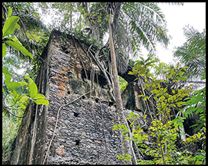
The sugar mill at Praia Melão
The island's mountainous and heavily forested interior and south constrained early settlement to the small coastal plains below 200m in elevation in the north and northeast (Tenreiro Reference Tenreiro1961). Large expanses of land were cleared and planted with sugarcane, estates were developed, and sugar mills were built near rivers and streams radiating from the mountains to the sea. Today, the engenho at Praia Melão is the only known sugar mill and estate house on São Tomé (Figure 2). References to it begin in the sixteenth century, identifying it as the largest estate on the island (Fonseca Reference Fonseca2010: 135). Archaeological survey has established its importance, and an urgent need for preservation and community engagement. The current project, started in 2020 and conducted in collaboration with Santomean colleagues, provides a basis for a heritage programme at the University of São Tomé e Príncipe that includes a field school, survey and excavation.

Figure 2. Estate house and sugar mill (view from SE corner) (photograph by M.D. Cruz).
The sugar mill and estate house (a single building) is located near the Ribeiro Manuel Jorge, which flows easterly to the Gulf of Guinea, south of the village of Praia Melão (Figure 1). It is a large stone building, refurbished and possibly expanded throughout its long existence. The building's features and clay roof tiles found on the surface reflect architectural styles common in Portuguese buildings. A nearby levada (mill race) channelled water to power the mill. Further evidence of sugar production includes fragments of sugar moulds and the stone base of a press.
The building is two storeys high, rectangular in plan (23 × 16m), and is divided into three areas. A large room (approximately 17 × 8.5m) adjacent to the head wall—a retaining wall that supported the mill race—and head-wall tail race housed the hydraulic mill or mills (Figure 3). The room next to it was most likely the sugar boiling room (casa de cozedura), suggested by the fire scorched walls. The living quarters occupied the upper floor, featuring wall cabinets, balconies, and windows that allowed surveillance of the working areas. Parts of the building have collapsed, and floors are covered by rubble that may conceal additional features but surviving walls are between 5m and 9m high. The upper-floor domestic areas are stuccoed, while work-area walls are roughly finished and exhibit graffiti with lettering, crosses and other religious symbols (Figures 4 & 5). As was common in contemporary Portuguese residences, the kitchen may have been outside, but neither it nor any slave quarters have been located (Figure 6).

Figure 3. Plan of two floors (A & B) and elevation of SW wall (C) (drawings by Anna Krahl).

Figure 4. Interior of work area: south wall and NW wall graffiti (photograph by M.D. Cruz).

Figure 5. Access to upper floor and graffiti. Lower level shows evidence of scorching (photograph by M.D. Cruz).

Figure 6. Architectonic reconstruction (drawing by Luís Branco).
Ceramics, particularly sugar moulds, litter the site surface and are embedded in refurbished walls (Figure 5c). Three sugar mould potsherds collected in the building interior were analysed using X-ray fluorescence by the Chemical Analysis Laboratory of TecMinho (Guimarães, Portugal), revealing that they belong to the same compositional group as sugar moulds from Madeira, which were produced in Aveiro. Portugal's Aveiro-Ovar region was a major centre for the export of domestic ceramics and of industrial ceramics for sugar production, so it is not surprising that the small sample from Praia Melão originated there (Morgado et al. Reference Morgado, Silva, Filipe, Teixeira and Bettencourt2012; Sousa & Castro Reference Sousa and Castro2012).
After the decline of sugar production on the island, the mill and estate house survived for about 400 years thanks to changes in function and adaptations that saw it producing alcohol and cassava flour, successively. Documents and oral information help situate the site in São Tomé's history, but despite its location along a well-used footpath, the neighbouring community is unaware of its significance. The tropical environment, encroaching vegetation, economic development and potential human impacts heighten the site's risk of destruction, making protection efforts and further archaeological investigations essential for its preservation.
Acknowledgements
Research undertaken in collaboration with the University of São Tomé e Príncipe and Direcção Geral de Cultura was supported by the Global South Studies Center and the Thyssen Foundation. Drawings are by Anna Krahl; architectural reconstructions by Luis Branco (Departamento de Gestão do Património Cultural da Câmara Municipal do Porto, Portugal).


