


The swampy river valley of Chodelka in Lublin, eastern Poland (Figure 1a), was one of the most densely populated Western Slav territories during the early medieval period (eighth to early eleventh century AD). At its confluence with the Vistula River, four strongholds and several settlements and barrow cemeteries were identified through archaeological investigations, all within a few square kilometres (Miechowicz Reference Miechowicz2018). One of these sites was a stronghold at the village of Kłodnica (Miechowicz Reference Miechowicz2018: 24–25) (Figure 1b). The site had a single, encircling rampart with a diameter of around 70m, now levelled by modern agriculture. It is located in the immediate vicinity of another stronghold at Żmijowiska (less than 1km away), and only 3km from an imposing tribal stronghold at Chodlik.

Figure 1. a) Map showing the location of the site; b) aerial photograph of the early medieval stronghold at Kłodnica during excavations (figure by Ł. Miechowicz).
The site lies adjacent to a discernible oxbow of the Vistula River, suggesting that it may originally have been located on the riverbank. In the surrounding fields, remains of an extensive settlement adjacent to the stronghold were located. The stronghold was investigated during fieldwork seasons conducted in 2016 and 2017, initially by geophysical prospection (Ryndziewicz & Miechowicz Reference Ryndziewicz, Miechowicz, Furmanek, Herbich and Mackiewicz2016; Miechowicz Reference Miechowicz2018: 24). Rectangular anomalies were revealed in the southern part of the area enclosed by the rampart. One of these anomalies was targeted for investigation, and excavation revealed the remains of a sunken building measuring 8 × 12m, sunk into the ground to a depth of 1m (Figure 2a). Due to modern cultivation, only half of the building was accessible for investigation. Its fill yielded one of the largest known deposits of charred crop remains, including the largest known assemblage of pulses in Europe.

Figure 2. a) Photogrammetric image of excavation of the granary; b) charred grains and storage vessel in situ; c) results of radiocarbon dating of a charred faba bean (Vicia faba var. minor) sample (dates calibrated using OxCal v4.2.3 and the IntCal13 calibration curve (Bronk Ramsey Reference Bronk Ramsey2013; Reimer et al. Reference Reimer2013)) (figure by Ł. Miechowicz).
In total, around 40dm3 of soil samples were analysed. In some cases, plant grains were so abundant that they made up almost half of the collected sample by volume. Thousands of pottery fragments, refitting into over 100 near-complete vessels, were recovered from the central part of the building, where the majority of plant remains were concentrated (Figure 2b). Charred bread remains were found in addition to cereal and pulse grains. Radiocarbon dating of a single faba bean (Vicia faba var. minor) provides a date for the burning of the building (at 95% confidence; calibrated using OxCal v4.2.3 and the IntCal13 calibration curve (Bronk Ramsey Reference Bronk Ramsey2013; Reimer et al. Reference Reimer2013)) at the beginning of the tenth to the first half of the eleventh century AD (Figure 2c). The huge quantity of charred plant remains found stored in vessels within the building suggests that it probably functioned as a granary.
Compared with other Polish sites (Kosina Reference Kosina1981; Koszałka & Strzelczyk Reference Koszałka and Strzelczyk2005) and medieval granaries in France (Ruas Reference Ruas2002; Ruas et al. Reference Ruas, Bouby, Py and Cazes2005; Vermard et al. Reference Vermard, Wiethold and Gazenbeek2008), Spain (Cuberto Corpas et al. Reference Cuberto Corpas, Ollich Castanyer, Rocafiguera Espona and de Ocaña Subirana2008) and Switzerland (Karg Reference Karg1995), the finds from Kłodnica clearly stand apart. Plant remains found elsewhere comprise predominantly cereal grains. At Kłodnica, however, legumes are the most abundant by volume. Two species—faba bean (Figure 3), and pea (Pisum sativum)—make up 70 per cent of all recovered crop remains. Common wheat (Triticum aestivum), rye (Secale cereale) and common millet (Panicum miliaceum) were most frequent among the cereals (Figure 4). Other plant taxa represent a negligible proportion of the total assemblage.

Figure 3. Faba bean (Vicia faba var. minor) seeds recovered from a single 0.5dm3 soil sample (photograph by A. Chlebicka).

Figure 4. Identified crop taxa by percentage of total volume (total volume of plant remains = 8.612dm3) (figure by G. Skrzyński).
Careful archaeological exploration and subsequent stratigraphic analysis, as well as appropriate archaeobotanical sampling, enabled reconstruction not only of the way different crops were stored within the granary, but also of the sequence of events that took place during the conflagration that marked the end of the building's use. Analysis of plant macro-remains indicate that the faba bean and pea crops were stored already mixed, and placed together with common wheat grains in a small pit or a shallow wooden box, slightly below floor level. Other less well represented plant taxa, such as rye and common millet, were stored in ceramic vessels placed on wooden shelves along the walls. During the conflagration, the shelves and other construction elements were burned, causing the vessels to fall and break apart, resulting in the mixing of their previously separated contents. This is also borne out by the fact that there are no evident traces of mixing between the main deposits of faba bean, pea and common wheat, although they are equally contaminated with other species, such as rye and common millet. An interpretation of finds of the infrequent species, such as common vetch (Vicia cf. sativa), barley (Hordeum vulgare), spelt (Triticum spelta), emmer (Triticum dicoccon) and oat (Avena sp.), is problematic. It is possible that they are remains of crops that were previously stored in the granary. It is also likely that these plants were not deliberately cultivated, but rather, grew as weeds amongst the main crops. Unambiguous crop weeds were also discovered among finds of charred seeds and fruits. The most numerous group of weeds (including corncockle (Agrostemma githago), European dodder (Cuscuta cf. europea), greater yellow-rattle (Rhinanthus serotinus) and another 12 taxa) was found in the common wheat deposit. Conversely, the aggregation of legumes was almost devoid of weed remains; this may be a result of the method used to obtain legume seeds by pod husking. The habitat preferences of crops and other plants (based on work by Zarzycki et al. Reference Zarzycki2002), such as soil trophism, pH and humidity, indicate that they probably grew in fields in the immediate vicinity of the stronghold.
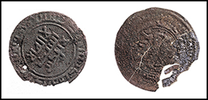
Excavations conducted at the small stronghold in Kłodnica also yielded non-botanical finds that reveal a wide network of interregional connections between this site and other regions of Europe. Among the finds were numerous metal objects, such as arrowheads, fragmentary agricultural tools and costume accessories. The latter includes the bronze fittings of a purse that are analogous to those found in a Scandinavian-type grave in Kiev and dated to the second half of the tenth century AD (Ievlev Reference Ievlev and Wołoszyn2009: 665 & fig. 6). Another rare find is a plough coulter with parallels from Great Moravia (Figure 5; Bartošková Reference Bartošková1986: 58–61 & 64). Truly exceptional is a necklace comprising 68 glass beads, some of which are covered with gold and silver foil, and two coins, both imitations of dirhams from Volga Bulgaria, dating to the 940s AD (Figure 6).
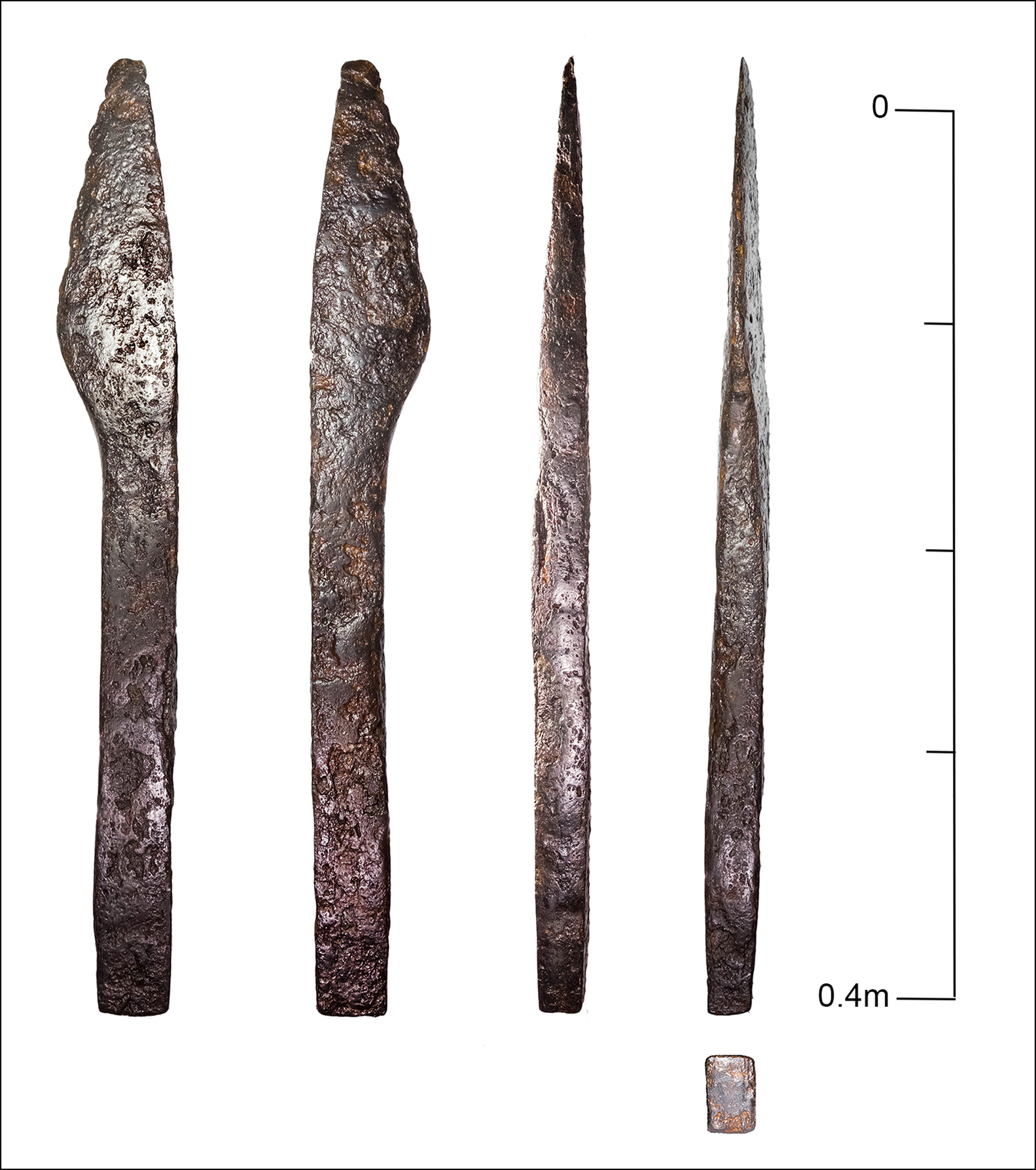
Figure 5. Plough coulter found within the building (photograph by Ł. Miechowicz).
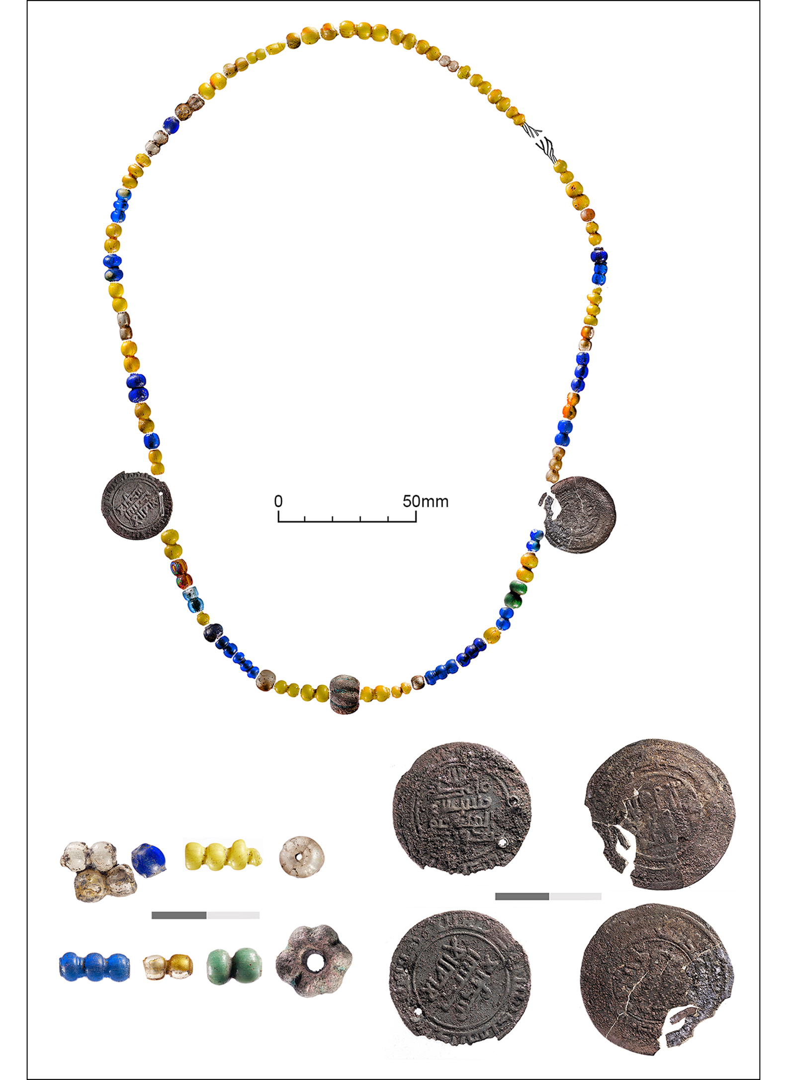
Figure 6. Reconstruction of a glass-bead necklace with coins, recovered from the granary building (figure by J. Stępnik).
The finds from Kłodnica illuminate the broader historical processes at play. At the end of the tenth century AD, the Chodelka river valley was incorporated into the growing Piast state (Buko Reference Buko2008: 190–96). It is possible that crops stored at Kłodnica constituted a form of tax collected by the resident Piast officials, or were kept as provisions for a garrison stationed there. The incident that preserved this extraordinary deposit may be connected with the dramatic events of the AD 1030s, relating to Czech and Russian raids and/or a pagan revolt aimed at dislodging the Christian Piast rulers.
Acknowledgements
The authors wish to express their thanks to Dr Bartek Lis, without whose support this text would not have been written.
Funding statement
The research was financed by funds from the Institute of Archaeology and Ethnology, Polish Academy of Sciences and the Museum of the Earth in Warsaw.


