INTRODUCTION
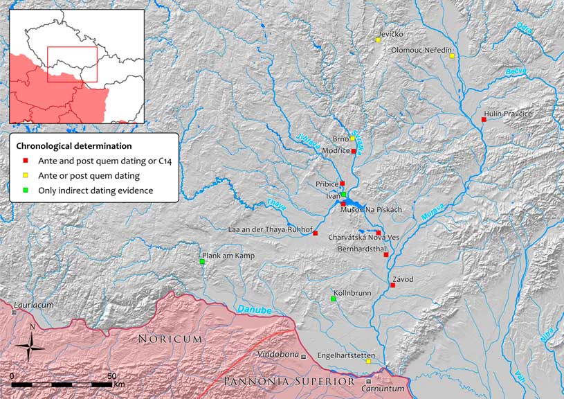
Starting at the turn of the eras, the Middle Danube region witnessed the establishment of two profoundly different worlds with a borderline at the course of the Danube: the Roman-provincial on one side and the Germanic-barbarian on the other. The Roman-barbarian interactions ranged from peaceful trading activities and military alliances to full-scale military conflicts. The temporary camps of the Roman army within the barbarian context of the Middle Danube region represent an exceptional group of components of archaeological interest and unique direct testimony of the Roman military presence (Figure 1; e.g. Hüssen and Rajtár Reference Hüssen and Rajtár1994; Tejral Reference Tejral1994; Komoróczy and Vlach Reference Komoróczy and Vlach2010; Komoróczy et al. Reference Komoróczy, Vlach, Hüssen, Lisá, Lend’áková and Groh2014; Rajtár Reference Rajtár2014; Groh et al. Reference Groh, Komoróczy, Vlach and Sedlmayer2015; Groh and Sedlmayer Reference Groh and Sedlmayer2015). Their total number has gradually grown to more than 30, distributed over a considerable geographic extent of the Germanic settlement territories, according to written sources the Marcomanni and Quadi. A complex of fortification structures with internal building on the hilltop of Mušov-Burgstall and its SE slopes at the confluence of the important regional rivers Jihlava, Svratka and Dyje (Thaya) stands out. The available archaeological data imply the presence of the Roman military headquarters and a logistical base in the heart of the tribal settlement territory (e.g. Komoróczy Reference Komoróczy2008, Reference Komoróczy2009a; Tejral Reference Tejral1999, Reference Tejral2014).
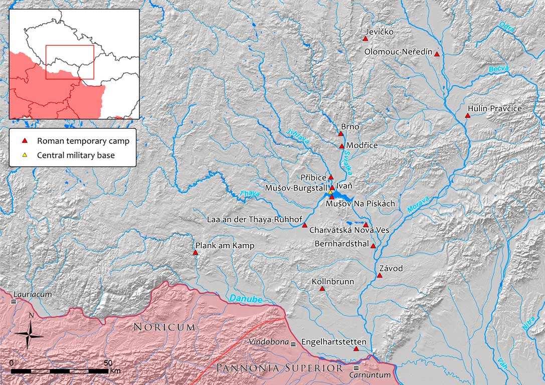
Figure 1 Distribution of the verified temporary camps of the Roman army in the Middle Danube region to the west of the Little Carpathians.
In the case of the temporary camps, the present state of knowledge and its development during the 20th century apparently reflect the modern political boundaries of the regions of Moravia (Czech Republic), SE Slovakia and Lower Austria, as well as methodological approaches to the topic since the first discovery of a temporary camp in Kollnbrunn (Lower Austria) in 1984 and, in particular, the later series of discoveries enabled by aerial survey during the last decade of the 20th century (cf. Bálek et al. Reference Bálek, Droberjar and Šedo1994; Kovárník Reference Kovárník1997; Tejral Reference Tejral1999). The variety of persisting fundamental questions, not yet satisfactorily resolved (e.g. dating, differentiation of function and ranking of individual installations, the dynamics and extent of the Roman military presence), led to the necessity of studying this unique source of information in a new way (cf. Komoróczy et al. Reference Komoróczy, Vlach, Hüssen, Lisá, Lend’áková and Groh2014; Groh et al. Reference Groh, Komoróczy, Vlach and Sedlmayer2015). The combined efforts of the Institute of Archaeology of the Czech Academy of Sciences, Brno (B. Komoróczy, M. Vlach), the Austrian Institute of Archaeology, Vienna (S. Groh, H. Sedlmayer), the Institute of Archaeology of the Slovak Academy of Sciences, Nitra (J. Rajtár, R. Ölvecky) and the Romano-Germanic Commission, Frankfurt am Main (C.-M. Hüssen) have led to a joint project. Basically, our study involves a wide range of methods designed to fill in the gap in the present state of knowledge within the study region. We have focused on several key questions, such as further examination of fortification structures and their construction and dynamics through the related lithological processes during and after the end of their primary function (cf. Lisá et al. Reference Lisá, Komoróczy, Vlach, Válek, Bajer, Kovárník, Rajtár, Hüssen and Šumberová2015). The paper reflects one of the main objectives of the project—to provide further chronological determination of the temporary camps whose dating has mostly been established on the basis of circumstantial archaeological data (stratigraphic relations, stray finds). The expected outcome is an increase in the possibility of associating individual field fortifications with well-established historical events. Most of the dates presented (see Table 1) have been acquired through the Poznań Radiocarbon Laboratory; the others have been produced by laboratories at the Vienna Environmental Research Accelerator (VERA) and the Centre for Applied Isotope Studies, University of Georgia in the USA (UGAMS). The resulting dates have been processed and calibrated in the web-based software OxCal 4.2 (Bronk Ramsey Reference Bronk Ramsey2009; Bronk Ramsey and Lee Reference Bronk Ramsey and Lee2013) using the calibration curve IntCal13 for the Northern Hemisphere (Reimer et al. Reference Reimer, Bard, Bayliss, Beck, Blackwell, Bronk Ramsey, Grootes, Guilderson, Haflidason, Hajdas, Hatt, Heaton, Hoffmann, Hogg, Hughen, Kaiser, Kromer, Manning, Niu, Reimer, Richards, Scott, Southon, Staff, Turney and van der Plicht2013).
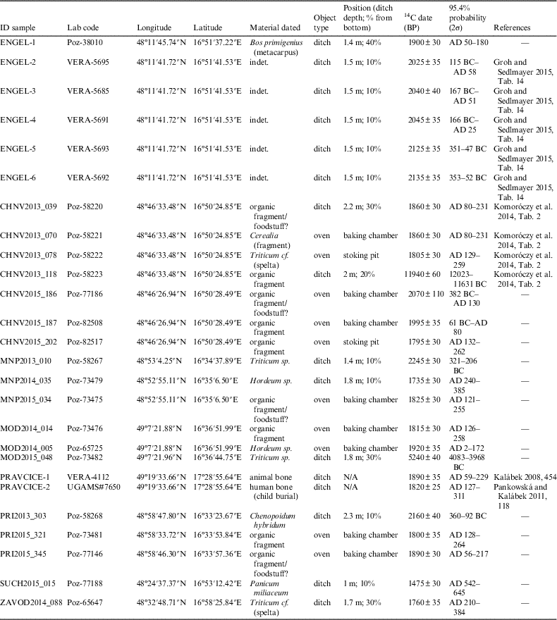
Table 1 Summary of the 14C dates from the Roman temporary camps to the west of the Little Carpathians.
The application of radiocarbon (14C) dating was expected to provide a qualitatively new segment of data with regard to the chronology of the temporary camps, particularly with a view to their association with particular warfare. The resolution of the available dating techniques does not allow one to distinguish individual phases of the Roman military presence which may have lasted for a maximum of several years, though their operating life can more probably be counted in months. There are multiple pieces of evidence of structural changes to individual fortifications (Charvátská Nová Ves, Mušov-Na Pískách) and non-overlapping in a single location (Přibice) which, along with other archaeological data, suggest a longer presence of the Roman military. Its narrow time span makes it impossible to discern their duration on the basis of 14C dating. On the other hand, an independent source of chronological determination of such fundamental archaeological components may help to widen the information basis and contribute to the resolution of several key questions relating to the Central European archaeology of the Roman Period. The use of 14C dating has also been motivated by its previous successful application in the context of temporary camps in Roman Britain, e.g. in Kintore (Alexander Reference Alexander2000).
Chronology and Historical Framework
A key area of the research activities has been clarification of their chronological characteristics based to date primarily on archaeological evidence of a movable (mainly in the form of stray finds of Roman military equipment and weapons) and immovable nature (observed stratigraphic relations to previous or subsequent Germanic settlement activities). Most of the pieces of evidence can be dated to the second half of the 2nd century AD with individual chronological outliers (e.g. Tejral Reference Tejral1994: 306f., Reference Tejral1999; Komoróczy Reference Komoróczy2009a). Traditional archaeological research, closely connected with written sources, associates such evidence with the extensive and long-lasting military conflict called the Marcomannic Wars (cf. Böhme Reference Böhme1975; Friesinger et al. Reference Friesinger, Tejral and Stuppner1994; Kovárník Reference Kovárník1997; Komoróczy Reference Komoróczy2008: 422f.; Fischer Reference Fischer2012; Rajtár Reference Rajtár2014, etc.); according to available contemporary written sources these took place under Emperor Marcus Aurelius between AD 166 and 180. Roman offensives in barbarian territory took place with varied intensity from AD 172 onwards. Nevertheless, sparse evidence also indicates the possibility of a Roman military presence shortly after the turn of the eras during the campaign against the Marcomannic King Maroboduus in AD 6 (Bálek and Šedo Reference Bálek and Šedo1996; Tejral Reference Tejral2009). Written sources suggest that the growing power (military alliance with neighboring tribes) of the Roman-educated chief Maroboduus finally made the Roman administration plan a large-scale military operation (e.g. Salač and Bemmann Reference Salač and Bemmann2009). Nevertheless, there are doubts that the campaign itself proceeded any further from the planning phase (Kehne Reference Kehne2001: 294; Reference Kehne2006, Reference Kehne2009), while the archaeological data are still the subject of debate (Komoróczy Reference Komoróczy2009b). The so-called Domitian Wars during the penultimate decade of the 1st century AD (e.g. Jones Reference Jones2002: 150–54) cannot be completely ruled out either. The conflict had presumably begun because of withheld military aid of the Germanic tribes against the Dacians. Moreover, the Legio XXI Rapax should have suffered a crushing defeat somewhere in the Middle Danube region (Pollard and Berry Reference Pollard and Berry2012: 81). However, there is no convincing evidence to date that the conflict indeed took place on barbarian territory in the Middle Danube region. The archaeological data are missing, however, for any possible confrontations in the 3rd and 4th centuries AD.
Context and Characteristics of the Dating Samples
In addition to confirming the linear course of the fortification ditches and entrances, the latest research activities also discovered the presence of field ovens (Figure 2; cf. Komoróczy et al. Reference Komoróczy, Vlach, Hüssen, Lisá, Lend’áková and Groh2014) sometimes detected in considerable number of the order of tens or even hundreds within the fortified area of the camps, spatially aligned on the interior side of the fortification line. Many small-scale trench excavations of the camp fortification line included bipartite pyrotechnological features (field ovens for food preparation). A distinctively regular spatial alignment of field ovens on the interior side of the fortification line was made evident by magnetometric surveys in multiple temporary camps (Charvátská Nová Ves, Mušov-Na Pískách, Přibice, Laa an der Thaya-Ruhhof and Kollnbrunn). In terrain research they uniformly consisted of a vaulted baking chamber, as reflected by fragments of daub, and stoking pit often with abundant pieces of charcoal.
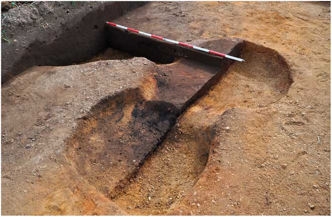
Figure 2 Example of an excavated standard bipartite field oven in a temporary camp (Charvátská Nová Ves).
The collection of samples suitable for 14C dating has several limitations in this area. Most camps lay on Tertiary terraces composed of relatively unsolidified sands and pebbles and showing generally arid conditions which provided a relative scarcity of suitable material despite relatively intensive sediment flotation. Such deficiency was evidenced in several examined segments of V-shaped ditches. The sampling strategy focused on key stratigraphic features (particularly below redeposited rampart features), mostly the lowermost parts of the fortification ditch and the parts potentially as close as possible to the camp abandonment.
On the other hand, the field ovens yielded relatively abundant and varied archaeobotanical material (see Table 1), although differing in individual situations. In some of the situations, an oven has been swept empty and cleaned after its terminal use (e.g. Přibice), whereas others exhibited abundant charred remains of firewood, domesticated forms of Cerealia, as well as ruderal species (e.g. Modřice). Charred remains of anthropogenic origin with material microscopic structures (“bubbles” from expanded air during the baking process) and traces of surface shaping allowing interpretation of some of them as foodstuff fragments, probably associable with simple legionary bread (cf. Junkelmann Reference Junkelmann1997), were identified among the botanical macroremains acquired by flotation. Nevertheless, discernment of comparable features was not possible in several cases which have been identified as general “organic matter” and used for dating due to the scarcity of other materials (or the lowermost ones in the case of ditches). Better interpretation possibilities are provided by the relative “enclosedness” of field ovens in general as compared to the “openness” of V-shaped ditches (Figure 3)—the latter provide ample opportunity for the intrusion of unrelated material which may be younger or even older in the case of disruption to previous features by Roman building activity. In some instances, human (child burial from Hulín-Pravčice; Kalábek Reference Kalábek2008: 454) and animal (Engelhartstetten) bones were used for dating.

Figure 3 Standard section trench of the fortification ditch in the northern central part of the camp (Charvátská Nová Ves).
From the perspective of stratigraphic context development, Roman fortification ditches represent specific features which generally exhibit pattern similarities, though with divergences based on field records of the excavated archaeological contexts (for the micro-stratigraphic and lithological perspective see Lisá et al. Reference Lisá, Komoróczy, Vlach, Válek, Bajer, Kovárník, Rajtár, Hüssen and Šumberová2015). Generally, they consist of tongue-shaped thin layers reflecting the initial phases of erosion of ditch walls and ramparts after their abandonment. Short and quick phases of deposition correlate with the limited amounts of suitable botanical macroremains. These lowermost parts are then overlain with deposits more rich in humus with slower aggradation, stabilized by grown vegetation inhibiting the erosion processes (changing hydrological conditions) or bioturbations (activities of small fauna and plant roots). The central part usually consists of sediments corresponding to subsoil material reflecting the redeposition of rampart remains into the ditch, often almost completely untransformed by pedogenic processes. This suggests that after some unspecific period of natural aggradation, the remaining parts of the rampart have been intentionally redeposited into the depression to remove an obstacle.
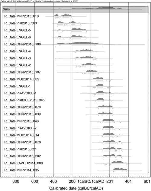
Most of the samples studied were acquired by flotation of sediment extracted from the excavated backfills. Various sampling methods were tested, ranging from the pinpointing of features of special interest and grid-based selective sampling to ”total” sediment flotation, as tested in Engelhartstetten (Groh and Komoróczy Reference Groh and Komoróczy2011; Groh and Sedlmayer Reference Groh and Sedlmayer2015: 14ff), which provided a quantity of small finds otherwise unidentifiable through the standard methods of excavation and macroscopic observation. The selection of samples suitable for dating was aimed at material with the assumed shortest possible presence in the carbon cycle in order to maximize the representativeness of the resulting chronological probability distributions. Primarily, the carbonized botanical macroremains of seasonally growing plant species were used. At present, a total of 26 dates (for the coding of 14C dating samples see Table 1 and Figure 4) are available from the camps in the Czech Republic (Charvátská Nová Ves, 7 dates; Mušov-Na Pískách, 3 dates; Přibice, 3 dates; Modřice, 3 dates; Hulín-Pravčice, 2 dates), SW Slovakia (Závod, 1 date; Suchohrad, 1 date), and Lower Austria (Engelhartstetten, 6 dates). The series of 4 radiocarbon dates from Charvátská Nová Ves was published previously in Komoróczy et al. (Reference Komoróczy, Vlach, Hüssen, Lisá, Lend’áková and Groh2014) as a part of ongoing project work, pointing out the possibilities of absolute dating in the case of the Roman temporary camps. The individual sites can be briefly characterized as follows.
Figure 4 Outline of the available 14C dates from the temporary camps within the chronological boundaries of the La Tène and Roman Periods (see Table 1).
Charvátská Nová Ves (Břeclav District, South Moravia, Czech Republic)
This site represents one of the most extensive fortification structures (ID 1a; 41.2 hectares) in the Middle Danube region, located on an extensive flat Tertiary terrace above the vast alluvial floodplain of the lower reaches of the River Thaya (Kovárník Reference Kovárník1997: 62, Taf. 8; Tejral 1997: 535, Fig. 6; 1999, 123, Abb. 32; Vlach Reference Vlach2008), about 15 km to the north of its confluence with the River Morava. In addition to the previously known fortification, the latest survey activities (cf. Komoróczy et al. Reference Komoróczy, Vlach, Hüssen, Lisá, Lend’áková and Groh2014) have discovered new fortification structures. The first one (ID 1b) represents an additional internal reduction of the main camp area (approximately 10 hectares) and the second is an adjoined fortification (ID 2). The archaeological contexts of excavated field ovens, rich in suitable botanical material (foremost charred firewood), provided 4 samples for dating (CHNV2013_070, CHNV2013_078, CHNV2015_186, CHNV2015_187 and CHNV2015_202). In most cases, these are based on material interpreted as the remains of foodstuff as well as botanical material (Cerealia, Triticum spelta). A sufficient amount of botanical macroremains from the lowermost parts of the excavated fortification sections (the main course of the fortification and a titulum) also provided 2 samples for 14C dating (CHNV2013_018 and CHNV2013_039).
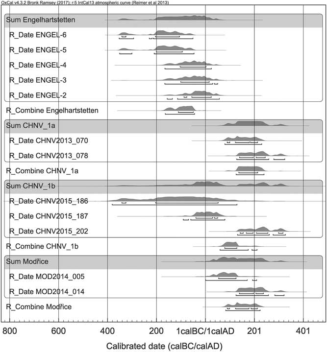
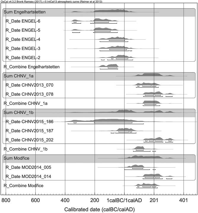
Figure 5 Dates and probability distributions of the samples from the same (or adjoined) context using the Combine function (Engelhartstetten, Charvátská Nová Ves 1a and 1b and Modřice).

Figure 6 Middle Danube region. Current state of available dating possibilities for the verified temporary camps. (Peška and Šrámek Reference Peška and Šrámek2004; Stuppner Reference Stuppner2008; Groh and Sedlmayer Reference Groh and Sedlmayer2015).
Mušov-Na Pískách (Břeclav District, South Moravia, Czech Republic)
To date, this location in the alluvial landscape on an extensive flat sandy fluvial terrace above the River Thaya has provided the most comprehensive and most numerous evidence of Roman building activities in a temporary field encampment in the region (e.g. Bálek et al. Reference Bálek, Droberjar and Šedo1994: 62–64, Abb. 6; Kovárník Reference Kovárník1997; Tejral Reference Tejral1999: 135f., Abb. 7). This is situated opposite the central military base at Mušov-Burgstall and the adjacent communication corridors (Komoróczy and Vlach Reference Komoróczy and Vlach2010: 259ff., obr. 14). The initial excavations have proved dating of the largest fortification to the second half of the 2nd century AD terminus post quem based on its stratigraphic position with a Germanic dwelling (Komoróczy Reference Komoróczy1999). Since their discovery, the number of centrally located camps has increased from 2 to 4, representing gradual symmetrical reductions (ID 1b, 37.5 hectares; ID 1c, 21.1 hectares; ID 1d, 7.8 hectares) of the initial fortification structure of the largest extent (ID 1a, 41.3 hectares). The camp ID 2 represents the smallest fortification structure with an area of only 1 hectare, aligned with the edge of the W part of the terrace and interpreted as the remains of a fortified anchorage ground. A completely new enclosure (ID 3), which also coincides with the largest camps (1a and 1b), was uncovered in the northern part of the terrace. In total, 3 samples for 14C dating have been acquired from the location Mušov-Na Pískách. Two samples come from the lowermost parts of backfill of the excavated segments of V-shaped ditches of the camps ID 2 (eastern side of fortification) and 1a (MNP2013_010, Triticum sp.; MNP2015_035, organic fragment), while the third comes from a field oven of camp ID 1a (MNP2015_034, Hordeum sp.).
Přibice (Břeclav District, South Moravia, Czech Republic)
Multiple evidence of temporary camps has previously been found with the help of an aerial survey in geomorphologically variable conditions to the north of Přibice in an extensive area 1 km long, on the terraces along the River Jihlava (Bálek et al. Reference Bálek, Droberjar and Šedo1994: 66–68, Abb. 4, 5, 7, 11; Bálek and Šedo Reference Bálek and Šedo1998, obr. 8; Kovárník Reference Kovárník1997: 89; Tejral Reference Tejral1999: 120, Abb. 29), 8 km to the north of the central military base at Mušov-Burgstall. The three fortification structures differ from each other distinctively in size, and their mutual spatial arrangement with no superposition relations suggests a close chronological position. The smallest camp (ID 2) with an estimated fortified area of 1 hectare is located on and aligned with a stepped edge of the lowermost terrace level above the alluvial landscape of the River Jihlava. The area of the river terrace also yielded a lot of evidence of settlement activities from the La Tène Period and the Early Middle Ages, also including a small 15th century motte-type fortification (Bálek Reference Bálek1995: 245). A sample was acquired from the lowermost part of the backfill of an excavated ditch section (PRI2013_303; Triticum sp.). The second largest camp in Přibice (ID 1; 25.8 hectares) has the same orientation as ID 2; it is situated westward up the slope and its partial localization on a relatively steep slope represents an extraordinary context. The third and largest camp (ID 3) in Přibice covers an area of 43 hectares which also represents the most extensive fortified area to the west of the Little Carpathians. Camp ID 1 did not provide any datable material, for which reason selected field ovens have been examined. These ovens yielded macroremains suitable either for camp ID 2 (PRI2015_345) or ID 3 (PRI2015_321). In both cases, determination was performed with samples identified as organic fragments which were probably connected with the function of the examined devices (fragment of produced foodstuff, interpreted as probable remains of military bread).
Modřice (Brno-Venkov District, South Moravia, Czech Republic)
This camp is situated in the southern outskirts of Brno above the edge of a terrace above the alluvial landscape of the River Svratka. Its discovery during the excavations also revealed its intersection with a Germanic dwelling allowing post quem dating of the fortification to the second half of the 2nd century AD (Komoróczy Reference Komoróczy2002). A recent geophysical survey allowed us to recognize the only accessible, southern, part of the camp, also revealing several other archaeological and geological features including characteristic arrays of field ovens. One of these was verified by field research and the flotation of its infill provided abundant and varied botanical macroremains for 14C dating (MOD2014_014, Triticum sp.; MOD2015_005, Hordeum sp.). One sample was also acquired from the lowermost part of the infill of the excavated section of a V-shaped ditch (MOD2015_048) in which only an organic fragment, interpreted as a food remnant, was available.
Hulín-Pravčice (Prostějov District, Central Moravia, Czech Republic)
The camp was found during a rescue excavation in the transept for a motorway in the cadastral districts of Hulín and Pravčice in the Upper Morava Valley, and currently represents the easternmost temporary camp within the studied region (Kalábek Reference Kalábek2008; Daňhel et al. Reference Daňhel, Kalábek, Klanicová, Pankowská and Paulus2009). The area of the camp included, among other things, traces of a Germanic settlement as well as trace of burial activities. A total of 2 available dates have previously been published. The first date (PRAVCICE-1; Kalábek Reference Kalábek2008, 454, Graf 1) was acquired from an animal bone and the second (PRAVCICE-2; Pankowská and Kalábek Reference Pankowská and Kalábek2011: 118) from a human bone (Germanic inhumation burial), both found in the backfill of a V-shaped ditch.
Závod (Malacky District, Záhorie Region, Slovakia)
The camp with a relatively modest fortified area of 4.2 hectares is situated just a few kilometres below the confluence of the regionally significant rivers Thaya and Morava. It lies on a flat sandy gravel terrace which is also rich in other archaeological components dating from prehistory to the Middle Ages (cf. Elschek and Rajtár Reference Elschek and Rajtár2008; Rajtár Reference Rajtár2014: 123–4). One sample for 14C dating (ZAVOD2014_088, Triticum spelta) was acquired from a ditch stratum rich in charcoal pieces, organic matter and archaeological finds (Germanic pottery, Samian ware from the Severan Period, bones, etc.), which are interpreted as the remains of Germanic settlement activities subsequent to the decline of the primary function of the temporary camp and initial phases of the ditch backfilling process.
Suchohrad (Malacky District, Záhorie Region, Slovakia)
The camp is situated opposite the Stillfried hilltop on the right bank of the River Morava where only indirect evidence of the Roman military presence is known to date (military equipment and stamped bricks; see Rajtár Reference Rajtár2014: 122–123; Stuppner Reference Stuppner2008: 55–56). It is located on a sandy fluvial dune-shaped feature and its size is estimated as up to 1 hectare. The sample for 14C dating was acquired from the lowermost part of the ditch backfill (SUCH2015_015; Panicum miliaceum).
Engelhartstetten (Gänserndorf District, Lower Austria)
The largest camp (47.2 hectares) to the west of the Little Carpathians (cf. Groh and Sedlmayer Reference Groh and Sedlmayer2015: 14ff.) with an almost regular square shape is located only 8 km across the Danube to the north of the extensive ancient agglomeration of Carnuntum. The distinctive flatland character of the region around Engelhartstetten was principally shaped by fluvial activity. The pilot research activities of the project (Groh and Komoróczy Reference Groh and Komoróczy2011; Groh et al. Reference Groh, Komoróczy, Vlach and Sedlmayer2015) and joint small-scale field research have taken place at this site. Settlement activities from the Late La Tène Period have been found by magnetic and artifact surveys in the vicinity of excavated sections of the fortification segment. The first date from the site (ENGEL-1; Bos primigenius) provided a probability distribution within the margins of the Roman Period. However, most of the dates were acquired from botanical macroremains (ENGEL-2 – 6; with identical context of origin and combined in the next chapter) and refer to various phases of the La Tène settlement activities whose remains have been redeposited into the ditch (Groh and Sedlmayer Reference Groh and Sedlmayer2015: 180f., Tab. 14). The latest dating to the Augustan period (Groh and Sedlmayer Reference Groh and Sedlmayer2015: 45–54, 156), based largely on archaeological finds from metal-detector prospections, have been questioned at several points recently (Erdrich Reference Erdrich2017: 236–248).
RESULTS AND DISCUSSION
Evaluation of the Roman Military Presence and Chronological Boundaries
To date, all the available material from the temporary camps suitable for 14C dating has yielded 26 dates (see Table 1). In addition to the issue of temporary camp dating, the available data set makes it possible to draw some general conclusions. As expected, the 14C dates acquired from field ovens provided more coherent probability distributions compared to those from V-shaped ditches which is mainly the result of the distinctly different nature of their post-deposition and formation processes of an archaeological context (see Lisá et al. Reference Lisá, Komoróczy, Vlach, Válek, Bajer, Kovárník, Rajtár, Hüssen and Šumberová2015).
It is nevertheless noteworthy that the dates from the V-shaped ditches in general, if not belonging to the timeframe of the Roman Period, mostly refer to previous periods (except for Suchohrad). The variously differentiated chronological dispersion within the timeframe of the Roman Period reflects the possibility of intrusions caused by various causes. For example, the remarkably outlying date of roughly 12k cal BC from the titulum infills of the northern gate in Charvátská Nová Ves (CHNV2013_118, undeterminable fragment of plant) clearly represents an example of intrusion, as no archaeological components other than those dated to the Roman Period have been found in the excavated location and its vicinity. Considerable Roman building activities inevitably disturbed multiple features and layers from previous periods of various ages, even quite remote periods. These relocated deposits with relevant botanical macroremains were also logically among the first to be deposited at the bottom of the ditch after the abandonment of the fortification. The same is true of the situation in Modřice, where the date MOD2015_048 (Triticum sp.) falls within the beginning of the Late Neolithic development which was also confirmed by artifact survey in the area. In Modřice, we have also recorded the presence of recent botanical material in some of the ditch backfills, possibly transported by micro-fauna.
A large number of the dates outside the Roman Period fall within the immediately preceding La Tène Period (ca. 400–50 BC). This particular situation was recorded in Engelhartstetten (ENGEL-5 – 6), Přibice (PRI2013_303) and Mušov-Na Pískách (MNP2013_010). It is noteworthy that in all these cases the excavated course of the fortification was found in the vicinity of, or in direct intersection with, the previous early historic settlement activities, in all cases related to the La Tène Period. However, a large amount of archaeological data and other dates (stratigraphic relations, stray finds) in Přibice and Mušov-Na Pískách testify to the second half of the 2nd century AD. For example, in Engelhartstetten, respectively dated archaeological material has also been found in the ditch backfill (Groh and Sedlmayer Reference Groh and Sedlmayer2015: 45–46). The previous necessity of further re-evaluation of the evidence from Suchohrad has also been strengthened by the results of 14C dating (SUCH2015_015) and may eventually suggest rather later dating of the fortification, probably to the end of the Migration Period (the whole period ca. 400–600 AD) and the beginning of the Early Middle Ages (the whole period ca 600–1200 AD). It is also noteworthy that the site provided archaeological material from the last-mentioned periods (see Fusek and Zábojník Reference Fusek and Zábojník2010) as well as from the Roman Period (Rajtár Reference Rajtár2014: 122–123). Nevertheless, for the time being, its identification as a type of structure other than a standard temporary camp cannot be ruled out. At the same time, its possible intrusion cannot be ruled out either on the basis of the one date currently available.
In a few cases in which more than one date comes from a particular context, the OxCal Combine function has also been used to further examine their chronological distributions (Figure 5). The most representative data set from Engelhartstetten consists of 5 samples (ENGEL-2 – 6) coming from an identical context at the bottom of the ditch. Evaluation using the Combine function provides a chronological interval at 2σ between 196 and 59 BC (date 2076 BP±17; χ2-test passed: T=8.5, 5% 9.5). This period ends half a century before the earliest Roman military presence in the Middle Danube region and most probably reflects La Tène settlement activities later redeposited into the lowermost part of the ditch infills (Groh and Sedlmayer Reference Groh and Sedlmayer2015: 181). The second case (CHNV_1a) represents two dates with similar chronological distributions (CHNV2013_070 and CHNV2013_078) from an oven (and stoking pit) at the fortification ID 1a (date 1833 BP±22; χ2-test passed: T=1.7, 5% 3.8) in Charvátská Nová Ves which representatively cover the 2σ chronological frame from AD 126 to 240. Three dates come from the same oven excavated at the fortification line ID 1b (spatial reduction of the camp ID 1a) in Charvátská Nová Ves (CHNV2015_186, CHNV2015_187 and CHNV2015_202). Inconsistent frames of probability distributions also resulted in low statistical representativeness producing a 2σ margin between AD 60 and 212 (date 1890 BP±23; χ2-test failed: T=21.8, 5% 6). Such a result is, however, corroborated by other 14C dates as well as archaeological evidence (e.g. Vlach Reference Vlach2008), particularly with respect to relation with the fortification ID 1a. The significantly wider distribution in the case of CHNV2015_186 is caused most probably by the limited amount of usable carbon (0.04 mgC). The last situation in which more than one date was ascertained from the same context comes from Modřice (MOD2014_005 and MOD2014_014). Nevertheless, it failed the χ2-test by a relatively narrow margin (date 1860 BP±23; χ2-test failed: T=5.2, 5% 3.8) and provided a 2σ chronological margin between 84 AD and 224 AD.
Concerning the Roman military installations in general, there is one more date from the central military base at Mušov (location Neurissen) which comes from the situation of a timber-and-daub framework residential building with an apse (Bálek and Šedo Reference Bálek and Šedo1996; Komoróczy Reference Komoróczy2009b). In the 2σ range, it covers the period from 50 BC to AD 125 (Tejral Reference Tejral2014: 241). Nevertheless, the wide range and the amount of archaeological data available to date clearly place the most significant Roman military activities to the seconf half of the 2nd century AD (Tejral Reference Tejral1994, Reference Tejral1999; Komoróczy Reference Komoróczy2008, Reference Komoróczy2009a). The central base at Mušov also differs from the scoped type of military installations—a temporary camp—significantly in several aspects, such as localization and geomorphology, the structure and dimensions of the fortification system, the character of building and the complexity of stratigraphic situations, as well as the amount and variety of archaeological material associable with the Roman military environment. Further clarification and evaluation of stages of use is part of ongoing research. One of the objectives of the joint project on the Roman temporary camps was to explore possibilities for the establishment of a source of chronological information additional to the dating based on archaeological data, particularly from these components and specifically due to the scarcity of datable contextual archaeological material.
CONCLUSIONS
The dates from temporary camps so far do not provide convincing support for their association with a Roman military campaign against the Germanic King Maroboduus shortly after the turn of the eras. A Roman campaign cannot be supported either by the data from field ovens or the chronologies of fortification ID 1b in Charvátská Nová Ves, which is a reduction of the larger camp ID 1a, convincingly falling within the second half of the 2nd century AD, or by the data from Engelhartstetten, where most of the data reflect La Tène Period settlement activities and where the dating to Augustan times has recently been disputed (Erdrich Reference Erdrich2017), for which reason this dating can presently be accepted only as terminus post quem. Despite the available archaeological data from the site, only further dates from possibly intact contexts may help to resolve the issue. However, the rest of the dates fall generally within the 2nd and 3rd centuries AD and, in the case of Závod, even within the 4th century AD, reflecting the archaeologically well-documented subsequent Germanic settlement activities following the Roman withdrawal in around AD 180. From the point of view of historically known and archaeologically well-attested confrontations, as well as from the perspective of the archaeological situations and material from individual sites available to date (e.g. Komoróczy Reference Komoróczy1999, Reference Komoróczy2002; Tejral Reference Tejral1999; Komoróczy and Vlach Reference Komoróczy and Vlach2010a), the conflict probably occurred during the Marcomannic Wars (cf. Kehne Reference Kehne2016) which can be identified with considerable certainty with a large number of the temporary camps (Charvátská Nová Ves, Přibice, Mušov-Na Pískách, Modřice, Hulín-Pravčice, and Závod).
ACKNOWLEDGMENTS
This paper originated within the framework of the program of internal support for international co-operation projects of the Czech Academy of Sciences (# M300011201) “The Roman Temporary Camps in Moravia and Lower Austria: multidisciplinary research – standard method – new historical interpretation” and within the framework of grant project of the Czech Science Foundation GA ČR no. 15-20700S “The Roman Period Cremation Burial Ground in Modřice and East Germanic Expansion Problems”.