

Chapter Three Ceremonial Armatures: Porticated Streets and Their Architectural Appendages
3.1 Prolegomena to Porticated Streets
Albeit with notable exceptions, modern scholars have tended to underestimate the importance of colonnaded (or porticated) streets in the urban fabric of late antique cities, particularly in the West.1 Even with regard to the East, where the majestic colonnaded avenues still visible in cities such as Palmyra, Apamea and Ephesus bring the monumental presence of these prepossessing features powerfully to life, there is nonetheless a continued inclination (again with notable exceptions) to propose their de-monumentalization by the later sixth century at the latest, following what remains a hallowed locus communis, the metamorphosis of the grand colonnaded thoroughfare of antiquity into the pullulating chaos of the medieval suq. Jean Sauvaget’s schematized diagram representing the chronological (d)evolution of the colonnaded street in his study of Laodicea of 1934,2 still often cited and reproduced, has become emblematic of the idea that even before the Arab conquest in the seventh century, colonnaded streets had seen their pristine monumentality compromised by the encroachment of shops and residences haphazardly built into the spaces between the columns and thence outward onto the paving of the streets themselves. Hugh Kennedy’s influential article of 1985 translated Sauvaget’s diagram into a paradigm more generally applicable to the cities of the Levant, which in his formulation were well on their way to becoming the teeming bazaars characteristic of the medieval period by the later sixth century;3 and Helen Saradi has recently further extended the presumed range of the phenomenon to the ‘Byzantine city’ of the sixth century in general.4
As we shall see, this perspective requires substantial modification. At least as late as the fifth century in the western Mediterranean and the sixth in the East, porticated streets were either refurbished or built anew with remarkable frequency, joining city walls and churches as much the most prolific monumental architectural forms of the era. Further, the partition walls and structures in generally irregular masonry or more perishable materials that ultimately did come to encroach on the intercolumnar spaces and sometimes – more to the point – the roadbeds of so many colonnaded streets are often extremely difficult to date even for methodologically advanced archaeologists. As the majority of the extant remains were uncovered before the widespread use of rigorously stratigraphic excavation techniques in the past few decades, the essential question of chronology remains very much open. Much of the encroachment once dated to the sixth century largely on the basis of a priori notions about the inexorable decline of the classical townscape already in that period may well belong to the ninth century or later.5 There are indeed a number of tantalizing indicators of the continued vitality of some streets, in both East and West, into the seventh and eighth centuries, when they apparently continued to frame the unfolding of urban ceremony in ways that suggest that their accessibility and their imposing architectural presence had not been fatally compromised either by unchecked decay or by the installation of shops and other commercial establishments, which had indeed been a ubiquitous presence in porticated streets throughout late antiquity, as we shall see, and for that matter under the high empire as well.6
Before proceeding, there is a brief matter of terminology and definitions to clear up. Strictly speaking, a colonnade is composed of columns, bearing either a flat (trabeated) entablature, or a series of arches (an arcade). In the West more often than the East (where the proximity of good sources of marble permitted a ready supply of monolithic columns), the trabeated and arcaded structures flanking streets were often supported by pillars of masonry or even wood, whence they cannot properly be called colonnades.7 Hence, I will hereafter prefer ‘porticated streets’ as a catchall designator for all such structures, and ‘colonnaded streets’ in the more restricted sense of the term. There is the further issue of what exactly constitutes a porticated street: my discussion of these structures will focus on streets lined by lengthy porticoes of relatively uniform aspect, as opposed to streets flanked by buildings with their own irregularly sized and spaced porticoes giving onto the roadbed, which will have presented a more heterogeneous and discontinuous appearance. A porticated street constitutes a cohesive architectural scheme that transcends the character of the individual structures situated behind the porticoes, imbuing the street as a whole with an architectonic identity essentially independent of the adjacent buildings, for all that these buildings are often directly connected to the porticoes.8
It should also be stressed that such streets started to proliferate long before late antiquity, beginning in the first century AD. The longest and perhaps the earliest of all is the cardo at Antioch, repaved and widened by King Herod at the turn of the millennium and lined on both sides, for its entire length of 2,275m, with continuous files of columns by the mid-first century AD.9 By the later second century, extensive colonnades lined both sides of one or more principal streets at cities across the eastern Mediterranean and North Africa, as well as at Rome itself and at a number of sites in western Europe (e.g., Lincoln, Reims, Italica), though the Eastern exemplars usually receive considerably more attention, as they tend to be both more monumental and better preserved.10 It was only with the imperially sponsored urban or quasi-urban foundations of the third century, however, that the colonnaded or porticated street came into its own as an indispensable element in the architectural language of imperial power, East and West, from Philippopolis in the 240s to the palace-city complexes erected by the Tetrarchic emperors, as we saw in the preceding chapter.
Thereafter, porticated streets became (with the exception of city walls) the most ubiquitous, expensive and ambitious form of secular monumental architecture erected from the later third century through the sixth, leaving an indelible stamp on the greatest cities of the late Roman – and post-Roman – world, and many others besides. The majority of the most extensive and costly street porticoes either restored, extended or constructed ex novo were located in prominent centers of civic and ecclesiastical administration, provincial and imperial capitals above all,11 which increasingly tended to gravitate around the colonnades that framed and connected the palaces and churches where rulers and bishops lived and performed their public duties.
Hence, an inquiry into the question of why the civic and, to a lesser extent, ecclesiastical authorities responsible for the most ambitious interventions in the urban topography of late antique cities devoted such a considerable portion of their limited resources to porticated streets should have much to reveal about the ways power and authority were enacted, publicized and given architectural form in the late Roman world. It should also help to explain the motives behind the development of the porticated street into the ‘imperial’ architectural feature par excellence in the third century, and the surprising persistence of these streets, and – more to the point – the ceremonial and commemorative praxis associated with them, through the sixth century and beyond in both East and West. Hence, the function of these grand avenues will concern us at least as much as their form. Our focus will be on the period ca. 300–600, which is rich enough in literary, epigraphic, archaeological and iconographic evidence to permit a relatively detailed perspective on the activities and ideological constructs that animated these streets and made them such indispensable features of the greatest cities of the epoch.
3.2 Imperial Capitals in Italy: Rome and Milan
In a fine recent article on colonnaded streets in Constantinople in late antiquity, it is stated that the city of Rome differed markedly from Constantinople in that it had no colonnaded streets worth speaking of in late antiquity.12 In reality, Rome had long featured extensive street porticoes. The most ideologically charged route in the city, the Triumphal Way followed by returning conquerors since the early days of the Republic, came to be lined by covered stone arcades over much or all of its urban tract, from the Bridge of Nero in the Campus Martius, through the Circus Flaminius and the Forum Boarium, and on past the Circus Maximus to the Forum Romanum.13 Elsewhere, following the catastrophic fire of AD 64, a number of principal thoroughfares in the devastated city center were reconstructed as wide, porticated avenues, which imbued the imperial capital with a stately veneer reminiscent of the royal capitals of the Hellenistic eastern Mediterranean.14 Nero’s gargantuan new palace, the domus aurea, gravitated around a triple portico said by Suetonius to be a mile long;15 and Nero’s architects encased the nearby Sacra Via – the final stretch of the Triumphal Way running through the forum to the Capitoline Hill – within lofty, arcaded porticoes at the same time.16
But the most extensive evidence for the erection of monumental street porticoes at Rome comes from late antiquity, beginning in the later fourth century, when several of the busiest and most symbolically charged axes of communication in the city were embellished with extensive porticated façades. Indeed, one of the most significant architectural interventions witnessed in Rome in the second half of the fourth century involved the erection of new porticoes along what was then becoming one of the very most important roads in the city, the street leading north through the Campus Martius to the Pons Aelius, the bridge leading to the mausoleum of Hadrian, and from there onward to St. Peter’s. As the evidence for the monumentalization of this street has been presented elsewhere,17 a resume of the salient points will suffice.
At the time of or soon after the construction of the Aurelian Wall in the 270s, the Pons Neronianus, the old Neronian bridge that served as the principal connection between the northern Campus Martius and the west bank of the Tiber, went out of use.18 Thereafter, all traffic on the two main roads in the area, the so-called Via Recta (the modern Via dei Coronari) leading east through the Campus Martius past the Baths of Nero and on to the Via Lata, and the Via Tecta, the porticated road running northwest from the Circus Flaminius, effectively the urban continuation of the ancient Via Triumphalis (the modern Via dei Banchi Vecchi), was diverted northward to the bridge leading to the Mausoleum of Hadrian, which subsequently became the sole crossing point in the northern Campus Martius. The decision to privilege the previously little-frequented Pons Aelius over the Pons Neronianus was presumably conditioned by defensive considerations, as the mausoleum was admirably suited to function as a fortified bridgehead on the far bank of the Tiber, allowing access to the bridge to be strictly controlled in a way that would have been impossible at the Pons Neronianus without the addition of substantial new structures at its western approaches. Traffic on the ‘Via Recta’ and Via Tecta was subsequently diverted north to the Pons Aelius along the modern Via del Banco Santo Spirito, as can be deduced in part from the fact that almost no traces of the paving of the ‘Via Recta’ and Via Tecta have been discovered between the point where they converged on the road leading to the mausoleum and the Pons Neronianus;19 the paving of these streets may indeed have been reused to monumentally re-edify the tract of road leading to the Pons Aelius, as may the columns from the tract of the Via Tecta situated between the intersection with the Via del Banco Santo Spirito and the Pons Neronianus, which had become a blind alley with the closure of the bridge (Figure 3.1).20
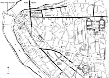
Figure 3.1 The western Campus Martius in Rome, with the route of the porticus maximae to the Pons Aelius and the arch of Valentinian, Valens and Gratian.
While this last point may be considered speculative, it is clear that the road leading to the Pons Aelius did indeed come to be flanked by impressive porticoes, which seem to have been installed, apparently for the first time, in the later fourth century. The key piece of evidence is the lost inscription from the triumphal arch of Valentinian, Valens and Gratian, completed ca. 380 athwart the southern approaches to the Pons Aelius, which survives in a ninth-century transcription: ‘Our lords, emperors and caesars Gratian, Valentinian and Theodosius, pious, fortunate and eternal augusti, commanded that (this) arch to conclude the whole project of the porticus maximae of their eternal name be built and adorned with their own money.’21 In addition to providing a firm date for the arch, the inscription strongly implies that the porticus maximae, which must refer to porticoes along the street leading to the arch, was realized in connection with, or shortly before, the arch itself, in what was clearly perceived as a unified architectural scheme, for which the arch served as the final and concluding element (arcum ad concludendum opus omne porticuum maximarum). The best conclusion is that the new porticoes extended the existing colonnades of the Via Tecta along the stretch of road leading to the only surviving river crossing in the area, which in turn provided access to St. Peter’s, one of the crucial nodes in Rome’s emerging Christian topography.22
The centrality of St. Peter’s in the spiritual and ceremonial life of Rome was further accentuated by the construction of an additional covered colonnade on the far side of the Tiber, flanking the road leading from the mausoleum of Hadrian to the church. While it is first securely attested in the Gothic War of Procopius, written in the mid-sixth century, the colonnade was likely built rather earlier, perhaps indeed shortly after or in connection with the porticus maximae, to which it would effectively have formed the extra-urban continuation, creating a nearly continuous colonnaded panorama stretching all the way from the Via Tecta in the intramural heart of the city, via the new arch of Valentinian, Valens and Gratian and the Pons Aelius, all the way to the Vatican.23
The other two most substantial street porticoes erected in late antique Rome led from the Porta Ostiensis in the Aurelian Wall along the Via Ostiensis to the church of St. Paul’s outside the walls; and from the Porta Tiburtina along the Via Tiburtina to the basilica of San Lorenzo. While they too are only known from later sources (of the mid-sixth and eighth centuries, respectively),24 both structures may well date as early as the later fourth century. They likely belong to approximately the same period as the portico leading to St. Peter’s, as the similarities in form and function common to all three suggest that they were conceived as interrelated parts of a unitary architectural scheme designed to connect the suburban shrines of Rome’s three most venerated martyrs with the Aurelian Wall, and thus with the city center. In the case of the portico to St. Paul’s, a date in the 380s appears especially likely, as it was in precisely this period (beginning in ca. 383–84) that the Constantinian church on the site was replaced by a massive new basilica sponsored by Valentinian II,25 the same Western emperor under whom, it should be remembered, the triumphal arch and the porticus maximae leading to the Pons Aelius were erected. It is surely as good a hypothesis as any that the imperial authorities, presumably working in concert with Pope Damasus (366–84), sought to monumentalize the route to the new St. Paul’s and link the church to the city center during or soon after its construction, by means of an imposing portico that mirrored the extra-mural extension of the porticus maximae leading to St. Peter’s. Damasus, of course, is best known for his tireless efforts to restore and popularize the suburban shrines of Rome’s leading martyrs,26 whence the temptation grows powerful to imagine that he actively collaborated in a scheme to anchor the devotional circuit of the Roman periphery he did so much to promote on three porticated ‘access roads’ leading to the shrines of Rome’s three greatest martyrs.
By the sixth century, when the annual liturgical calendar of the Roman church was largely complete, the three churches of St. Peter’s, St. Paul’s and San Lorenzo remained the only extramural shrines regularly visited by the popes in the course of the stational processions that increasingly came to define the sacred topography of the city.27 The porticated avenues thus provided a grandiose architectural framework for the ceremonial processions led by the popes to the three great extramural sanctuaries in the course of the annual liturgical cycle.28 The prominence of these processional routes in the topographical horizons of the city and the ideological agendas of its bishops was such that they continued to be maintained for centuries, often at enormous cost. In the late eighth century, Pope Hadrian I (772–95) restored all three porticoes, in the case of the route to St. Peter’s allegedly by reusing 12,000 tufa blocks taken from the embankments of the Tiber to complete the project.29
But while the popes may have been unusually successful in preserving the grand processional ways marked out in Rome in late antiquity into the early Middle Ages, similar porticoes once dominated the cityscapes of other Western capitals in late antiquity, notably those that superseded Rome as preferred imperial residences.
In Italy, Milan served as the primary seat of government from 286 until 402, during which time it too saw the erection of an architecturally prepossessing porticated avenue. As excavations undertaken in the 1980s during the construction of the MM3 underground line demonstrated, the new street took shape in ca. 375–80, and thus at almost exactly the moment when the porticus maximae at Rome were built, under the patronage of the same Italian emperor, Valentinian II. The Milanese porticoes were two stories high, and extended for nearly 600m along both sides of the road leading to Rome, beginning from the Porta Romana in the circuit-wall and terminating, again like the Roman exemplar, with a triumphal arch.30 Moreover, just as at Rome, the colonnades were linked to an especially prominent extramural church, the new Basilica Apostolorum built by Bishop Ambrose between 382 and 386 at the midway point of the newly aggrandized street (Figure 3.2).31 In light of the new evidence for dating the porticoes scant years before the appearance of the church, there is now better reason than ever to imagine – as past scholars operating under the assumption that the rebuilt street dated to the third century were already tempted to do32 – that the proximity of the imperial triumphal way was a determining factor in Ambrose’s decision to situate the first and most prestigious of his three (or four) great extramural churches adjacent to its porticoes.33 In so doing, Ambrose – surely consciously – reproduced the topographical relationship between St. Peter’s and the Via Triumphalis at Rome, and also, as we shall see, between a principal Constantinopolitan triumphal avenue and the city’s own church of the apostles, the Apostoleion, whose unusual cross-shaped plan directly inspired the cruciform layout of the Ambrosian Basilica Apostolorum.34 So too at Trier, the east end of the cathedral – suggestively dedicated to St. Peter and rebuilt under Valentinian and Gratian (364–83) – featured a twelve-sided aedicula enclosed within a massive square precinct, another Apostoleion in miniature that was, moreover, directly accessible from the porticated cardo departing from the Porta Nigra.35 In each case, we see civil and ecclesiastical authorities effectively collaborating in the creation of new, monumental urban itineraries, punctuated by imperially sponsored street porticoes, triumphal arches and city gates that provided a suitably grandiose setting for the formal processions that dominated the ceremonial repertoire of both church and state.36
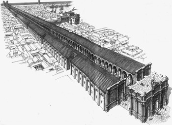
Figure 3.2 Milan: the via Romana colonnades and the Basilica Apostolorum.
The dedication of the Milanese church of the Apostles on May 9, 386 culminated with the translation and installation under the high altar of the relics of John the Baptist and the Apostles Andrew and Thomas, doubtless conveyed to the church in a festive procession along the Via Romana arcades.37 The event indeed left such an impression on the Christian faithful that when Ambrose later consecrated the Basilica Ambrosiana, the assembled crowd loudly demanded that he consecrate the new church with relics, as he had the basilica in Romana.38 The Basilica Apostolorum, that is, derived its vulgar name from the porticated (via) Romana whence it was accessed, which in the popular imagination – as well as in material reality – was inextricably connected with the church itself, as was the memory of the relic procession that accompanied its dedication. Motivated by the prompting of the crowd, Ambrose exhumed the bones of the local martyrs Gervasius and Protasius, which he conveyed to the Ambrosiana in a triumphal procession directly inspired by the protocols governing secular adventus.39 Nine years later, when Ambrose sought to exalt the remains of Nazarius, another local martyr, he sent them to the extramural church best architecturally equipped, by virtue of its monumental access road, to host yet another triumphal entry of relics: the basilica in Romana – Basilica Apostolorum, thereafter known also as S. Nazaro.40
The chronology of the monumental porticoes built along the approaches to several of the leading churches in Rome and Milan in the 380s is particularly noteworthy given that evidence of imperial participation in processions held to mark the translation of relics begins with the reign of Theodosius I (379–95).41 According to Sozomen, in 391 Theodosius solemnly carried the head of John the Baptist to his new church dedicated in the martyr’s name, located outside the Golden Gate at the Hebdomon, the same place from which newly raised emperors departed on their ceremonial entrance into Constantinople.42 In 406, Theodosius’ son Arcadius joined the Patriarch of Constantinople and members of the Senate in transporting the relics of Samuel into the city.43 In 411, these relics were deposited outside the new city walls at the church of St. John iucundianae at the Hebdomon, which took its name from the imperial palace of the same name located nearby.44 During the reign of Theodosius II (408–50), the emperor and members of the imperial family regularly participated in translations of relics, as when, in 421, the remains of Stephen were paraded through the city, in a style befitting of an imperial adventus, on their way to their final resting place at the oratory of St. Stephen, newly built inside the imperial palace itself, at the eastern extremity of the Mese, the main processional artery in the city.45 With the installation of the relics of both John the Baptist and Samuel at the Hebdomon, and those of Stephen at the palace inside the city, the starting and ending points of the imperial triumphal route along the Mese were bracketed by collections of newly installed relics, in the translation of which the imperial family had, moreover, actively participated. At San Nazaro, meanwhile, the relics of the eponymous martyr were ensconced in a chapel decorated with Libyan marble at the behest of the magister militum Stilicho’s wife, Serena, who prayed for her husband’s safe return from campaigning in the dedicatory inscription.46 Thus, at Milan, too, the church that seems to have become the preferred stage for the display of court-sponsored patronage of the cult of relics was the one most closely connected with the monumental route (the very road, perhaps, along which Serena hoped to see her husband return in triumph?) followed by imperial processions.
Beginning in the later fourth century, then, the rulers of the empire were evidently increasingly eager to link their public personae with the triumphs of the Christian church, and they actively collaborated with church leaders in the celebration, veneration and architectural framing of the martyrs who, in triumphing over death, had preserved orthodoxy and placed the Christian Roman empire over which they presided under divine protection.47 Ambrose himself, like many of his contemporaries, leaves no doubt that the arrival of relics was a triumphal occasion, best presented in the trappings of triumphal imperial adventus that would have been immediately familiar to the inhabitants of any imperial capital.48 Enthroned on the four-wheeled cart (plaustrum) used to convey arriving emperors in the fourth century, preceded by torches and standards, and hailed by the acclamations of the masses, the bones of the illustrious Christian dead were greeted with reverence otherwise reserved for reigning emperors.49 The transfer of relics to churches connected to the principal porticated streets of a late antique capital such as Milan could subsequently unfold in the same spaces used by the emperors for their own triumphal arrivals: a church procession through the porticoes of the Via Romana would inevitably have called to mind imperial processions along the same street. The connection between imperial and ecclesiastical ceremony thus received its definitive and lasting stamp in the realm of architectural space, in the form of a monumental processional way jointly exploited by civic luminaries and bishops. When the emperors themselves participated in translations of relics, the circle was closed: state and church triumphed together, as the representatives of each basked in the reflected glow of their counterparts. The imperial presence ennobled the ecclesiastical ceremony and proclaimed the unity of bishops and Christian sovereigns in the governance of the empire. The emperors themselves grew in the eyes of the Christian faithful, as the patrons and colleagues of the holy men tasked with stewarding the bones of the martyrs and mediating the access of the faithful to this most precious of all forms of spiritual currency.
3.3 Constantinople
The topographical nexus between imperial and ecclesiastical authority was nowhere more fully realized than in Constantinople, the ideal laboratory for the testing and elaboration of the urban paradigm envisioned by the first generations of Christian emperors. Officially inaugurated on May 11, 330, the birthday of its founder and namesake, the new city afforded Constantine and his successors in the fourth and fifth centuries a sort of architectural blank slate, onto which they were free to delineate an ideal vision of an imperial capital, largely unencumbered by the constraints of preexisting urban topography. In Constantine’s day, the new city center, built over and around the much smaller existing town of Byzantium, gravitated around an architectural core based on a single colonnaded main street, the Mese, that comprised the final tract of the principal land route leading to the city from Greece and the West, the Via Egnatia (Figure 3.3).50 After traversing the Golden Gate in the new land walls, the visitor approaching from the west arrived first at the Capitol – prime symbol of the ‘old’ Rome and so too of Constantine’s ‘new’ Rome51 – and the nearby precinct of the Philadelphion, a colonnaded square filled with statues and commemorative monuments to the emperors (among them the porphyry Tetrarchs now in Venice).52 From the Philadelphion, the Mese continued to the east, lined with majestic two-story colonnades, as far as the circular forum of Constantine, itself surrounded by colonnades two stories high, and graced at its center by a porphyry column topped by a gilded statue of Constantine.53
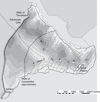
Figure 3.3 Constantinople. A: Forum of Arcadius; B: Apostoleion; C: Forum of the Ox/forum bovis; D: Philadelphion; E: Forum/column of Marcian; F: Forum of Theodosius; G: tetrapylon; H: Forum of Constantine; I: Baths of Zeuxippos; J. Hagia Sophia; K: hippodrome.
The two-story colonnades of the Mese thence continued east toward the milion, the Constantinopolitan equivalent of the umbilicus in the Roman Forum, marked by a monumental arch, likely a quadrifrons, spanning the street, just behind which stood a statue of an elephant, the very symbol of imperial triumph that adorned the quadrifrons arch at Antioch.54 To the north and south, the colonnades of a second avenue running perpendicular to the Mese converged on the archway, which thus stood, as at Antioch, Thessaloniki and Split, at the intersection of four radiating colonnaded axes, the shortest of which – again – led straight to the palace. This final stretch of the Mese, now wider and grander still and called – again – the Regia, stretched eastward from the milion to the main gate of the palace, known by the fifth century as the Chalke.55 The form of the gate appears to have been rectangular, with a domed central chamber straddling the axis of the Regia and two lower flanking bays, very much like the Arch of Galerius at Thessaloniki.56 North of the Regia stood the Augusteion, a colonnaded square flanked by a second senate house, joined under Constantius II (337–61) by the cathedral of Hagia Sophia and the palace of the patriarchs along its northern extremity.57 The Constantinian cathedral of the city, Hagia Eirene, lay just beyond to the northeast.58 To the south, the southern colonnade of the Regia gave onto the Baths of Zeuxippos and the carceres of the hippodrome, both rebuilt by Constantine and directly connected to the imperial palace itself, which sprawled south and east toward the shores of the Sea of Marmara (Figure 3.4).59
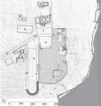
Figure 3.4 The area of the Great Palace in Constantinople. A: Hagia Eirene; B: Hagia Sophia; C: Augusteion; D: Mese; E: Milion; F: Chalke Gate; G: Baths of Zeuxippos; H: hippodrome; I: pulvinar; J: Peristyle Court; K: Yerebatan cistern; L: Palace of Lausos.
While the archaeological evidence is scanty and leaves infinite scope for haggling over the details, the basic contours of the palatial quarter in Constantinople as it took shape beginning under Constantine are clear enough.60 The complex gravitated around the Regia, itself framed at the west by the milion and at the east by the principal gate of the palace, the Chalke. The hippodrome and the greatest baths in the city (of Zeuxippos) stood just off the Regia, in the immediate vicinity of the entrance to the palace, and both in fact communicated directly with the palace to the rear, while their public entrances lay just off the colonnades of the street.61 By the fifth century (and probably earlier), the palace was also bodily attached to the cathedral of Hagia Sophia, via – yet another – colonnaded passageway, an elevated loggia by the sixth century, which connected the northern bay of the Chalke with the south flank of the church.62 Baths, hippodrome, arches, the imperial palace and the cathedral, all linked by the armature of a single, extraordinarily grandiose colonnaded avenue and further colonnaded extensions thereof: it is the culmination of the ‘imperial’ architectural paradigm that took shape in the third century, a cohesive ensemble that need not have exactly ‘copied’ any existing foundation to nonetheless reprise the essential features of all the imperial capitals and residences discussed in the preceding chapter, insofar as these can be known or surmised on the basis of the available evidence.
Later sources are surely right to suggest that already at the time of the dedication of the new capital in 330, the Mese with its associated monuments was conceived as a grand triumphal route. According to the eighth-century Parastaseis Syntomoi Chronikai, the founding ceremony on May 11 witnessed the transfer of a gilded statue of Constantine from the Capitol to the forum of Constantine, where it was laboriously raised, in front of the assembled people and dignitaries of the new city, up to its final resting place atop the porphyry column.63 In the words of Franz Alto Bauer, ‘The transfer of the statue to its new location appears to have been staged as a triumphal entry of the emperor into the city. An escort wearing white chlamydes, holding candles, accompanied the statue, which stood erect in a chariot, from the Philadelphion to the Forum of Constantine. Thus was staged the adventus of the emperor who, present in his statue, proceeded along the main street of Constantinople and finally reached “his” forum.’64
But while the transfer of the statue to the column was a one-time event, Constantine also made provision for a more lasting commemorative adventus, to be staged every year on the occasion of his birthday and the founding of the city. Again, the protagonist was (yet another) gilded statue of the emperor, ordinarily kept in a repository on the north side of the forum of Constantine, which every May 11 left the forum mounted on a triumphal chariot and processed down the Mese and into the hippodrome, where it made a lap of the track and came to rest in front of the imperial box (kathisma) to receive the obeisance of the reigning emperor.65 ‘By means of this ritual, therefore, the memory of the founding emperor was awakened in the consciousness of the populace; gilded, like the statue on the porphyry column ... He received the acclamation of the populace, the aristocracy and the emperor, before returning to the Forum of Constantine.’66
For more than a century following the death of Constantine in 337, succeeding emperors made it their task to extend the monumental framework of the Mese with a series of imperial forums and triumphal monuments arrayed along the main axis of the street. Theodosius I (379–95) built his forum between the forum of Constantine and the Capitol; the forum of Arcadius (395–408) took shape still farther to the east; and that of Theodosius II (408–50) rose between the old Constantinian walls and the new land walls of the city, built between 405 and 413.67 There, the road exited the city via the Porta Aurea, much the most magnificent gate in the new circuit, which took the shape of a triumphal arch dedicated to Theodosius II.68 New colonnades rose along the Mese in correspondence with the new forums, linking them all together in an unbroken progression of symbolically charged spaces designed to exalt the memory of their individual founders and propagate the timeless ideology of imperial victory upon which their claims to legitimacy and unchallenged sovereignty rested.69
At the Philadelphion, the main tract of the Mese on its way to the Porta Aurea diverged from a second colonnaded avenue, which angled northwest toward the Charisios (or Adrianople) Gate in the Theodosian walls. The centrality of this northern branch of the Mese in the landscape of the new city had been proclaimed already under Constantine himself, who erected his mausoleum just to the north of the road shortly before it traversed the Constantinian walls.70 The mausoleum, final resting place of the emperors through the reign of Anastastius I (d. 518),71 was flanked by the cruciform church of the apostles, the Apostoleion, probably begun in the 350s by Constantius and consecrated in 370.72 The fame of this church was such that Ambrose based the cruciform plan of his own Basilica Apostolorum at Milan on the Constantinopolitan exemplar;73 and the location of Ambrose’s church at the midway point of the Porta Romana colonnade strongly implies that the Milanese bishop was attempting more broadly to replicate the architectonic context of the Apostoleion and to ensure that his new foundation was similarly privileged by virtue of its physical proximity to the main ceremonial thoroughfare of the city.
In the mid-fifth century, when all of the prime locations along the southern branch of the Mese had been occupied by imperial monuments, the emperor Marcian (450–57) was compelled to establish his own forum along the northern extension of the Mese, between the Philadelphion and the Apostoleion.74 Thus, by the time of Marcian’s death, the architectonic imprint of the capital was largely complete. The most magnificent public buildings and forums in the city, as well as the churches of Hagia Sophia, Hagia Eirene and the Apostoleion, were either bisected by or proximate to the trunk of the Mese in the east and its two principal continuations in the west.75 These expansive, colonnaded thoroughfares were the spinal cord of the city as a whole, the architectural profile that imprinted itself on the consciousness of visitors and residents alike, and the repositories of the institutional memory encoded in their flanking monuments. The Mese anchored the ceremonial processions that gave tangible form to the ascendancy of Constantinople’s civic and ecclesiastical authorities, and at the same time channeled the flow of quotidian life and commerce through the most ideologically charged spaces in the city, the forums and commemorative columns bedecked with statues, reliefs and inscriptions that inevitably called to mind the mighty who had commissioned them, and who animated them on important occasions with their superhuman presence.76
When newly crowned emperors made their triumphal entrance into the city, as Leo I did in 457, or returned from extended absences, as Justinian did in 559, the entire population of the city, arranged sequentially and hierarchically according to rank and station, lined these streets and chanted their acclamations to the passing imperial cortege. On the most important days in the annual liturgical calendar, ecclesiastical processions followed the same route on their way to the leading shrines in the city.77 When relics arrived, such as those of Samuel in 406, Stephen in 421, and John Chrysostom in 438, these too made their adventus into the city along the Mese and its northern and southern extensions, conveyed in regal splendor by patriarchs and reigning emperors, whose joint participation in these processions ostentatiously proclaimed the ideal unity of church and state in a polity in which these two institutions grew ever more inseparable.78
Already in ca. 400, the presence of the emperor Arcadius and his wife Eudoxia featured prominently in the sermon John Chrysostom delivered upon the arrival of the relics of the Pontic martyr Phocas to Constantinople, in which, moreover, the physical essence of the city was distilled into a vision of its grand colonnades: ‘The city became splendid yesterday, splendid and illustrious, not because it has columns, but because it hosted the parade of the arriving martyr, who came to us from Pontus.’79 The newly arrived relics may have glorified the city as the colonnades alone never could have, but it was nonetheless the image of the colonnaded street that provided, in the mind of the bishop, the essential architectural backdrop for the solemn festivities that bound Arcadius and Eudoxia together with the clergy and the urban masses in joint veneration of Phocas’ mortal remains.80
3.4 Porticated Streets and the Literary Image of Late Antique Cityscapes
One of the great strengths of porticated streets was their capacity to channel the flow of both quotidian and ceremonial life within their confines: to direct movement along a limited number of privileged itineraries designed to highlight key civic monuments and connect them with grand colonnaded façades in a seamless topographical ensemble. The scattered civic monuments of the high imperial period, many of them falling into disrepair, and the teeming residential neighborhoods of the lower classes could be selectively filtered from view behind the lofty screens of porticoes lining the main streets of the late antique city. The testimony of contemporaries writing in the fourth and fifth centuries indicates that the urban experience was increasingly coming to be distilled into the visual and spatial parameters delineated by porticated avenues, which had become the essence of urban grandeur, the token by which a great city could be recognized and most succinctly defined.
One such indicator comes from the Notitia Urbis Constantinopolitanae, the extensive catalogue of urban topography in Constantinople compiled by an anonymous author writing ca. 425. While street colonnades are punctiliously listed in all of the fourteen chapters devoted to the various regions of the city, particularly evocative is the description of the seventh region, located in the ceremonial heart of the city, extending north from the Mese, between the forum of Theodosius and the forum of Constantine, as far as the shores of the Golden Horn. The summary description of the region that precedes the detailed listing of its component structures reads thus in its entirety:
In comparison to the previous one, the seventh region is flatter, though it too on its far extremity slopes steeply to the sea. From the right side of the column of Constantine all the way to the forum of Theodosius, it extends flanked by continuous colonnades, with other similar colonnades extending along the side streets, and continues, leaning downward as it were, all the way to the sea.81
For all that the seventh region was populous and densely built, it is the colonnaded sweep of the Mese between the forums of Constantine and Theodosius I, with its colonnaded cross-streets, that dominates the topographical panorama sketched by the author, and shapes the visual profile of the region as a whole. Visitors and residents alike might traverse the entirety of this central district of the capital without experiencing it as anything other than a continuous succession of stately colonnaded façades; the glorious illusion would give way to a more jumbled and heterogeneous reality only for those whose business carried them beyond the main roads.82
In his list of the twenty greatest cities of the empire, written ca. 380, Ausonius includes a similarly succinct description of the city of Milan, which concludes with reference to ‘her colonnades (peristyla) all adorned with marble statuary, her walls piled like an earthen rampart around the city’s edge.’83 The juxtaposition between city wall and colonnades is particularly striking, as it was the gates in the wall that framed the principal streets in the city, including the Via Romana with its grand new arcades, themselves under construction or very recently completed at the time when Ausonius was writing. For the visitor approaching from the south, Milan will indeed have been experienced precisely as the intersection of the porticated street and the city wall, which between them channeled the flow of traffic onto a single axis and screened from view all of the less monumental quarters of the city.
The predominance of porticated vistas in the imagination of late antique writers appears to herald a real shift in prevailing views, or mental images, of urban topography, for all that a similar inclination to condense the essence of urban civilization into colonnaded streets occasionally occurs earlier, notably in Achilles Tatius’ second-century description of Alexandria.84 In his lament for the martyrs of the Diocletianic persecution in Palestine in 309, Eusebius turns the morning dew on the colonnades of Caesarea into tears of sorrow wept by the city for its fallen: ‘The air was clear and bright and the appearance of the sky most serene, when suddenly throughout the city from the pillars which supported the public colonnades (stoai) many drops fell like tears; and the marketplaces and streets (agorai te kai plateiai), though there was no mist in the air, were moistened with sprinkled water.’85 For Eusebius, the columns of the street colonnades were evidently the most pervasive and characteristic feature of the cityscape, the architectural element best suited to express the mourning of the entire city: they were the eyes and the wounded heart of Caesarea personified. So too in the mind of the anonymous mid-fourth-century author of the Expositio totius mundi et gentium, the grandeur of Carthage is apparent in its regular grid of streets, which in their ordered symmetry called to his mind the image of an orchard.86 The columns lining the streets make the metaphor: in the urban orchard of Carthage, the rows of columns take the place of trees as the dominant visual element. Likewise in the imagination of John Chrysostom, as we have seen, the columns of Constantinople became a synecdoche for the architectural grandeur of the city as a whole.87
But by far the longest and most explicit surviving account of the place of colonnaded streets in the physical, social and mental geographies of the late antique metropolis comes in Libanius’ Oration 11, the Antiochikos.88 The text concludes with a topographical excursus on the city that runs to some ten pages in Downey’s edition, nearly half of which centers on the form, the beauty, and the function of the city’s colonnaded avenues, its grand central axis above all.
(196) And now it is the proper time to describe the situation and size of the city, for I think that there can be found none of those which now exist which possesses such size with such a fair situation. Beginning from the east it stretches out straight to the west, extending a double line of stoas. These are divided from each other by a street, open to the sky, which is paved over the whole of its width between the stoas ... (201) The stoas have the appearance of rivers which flow for the greatest distance through the city, while the side streets seem like canals drawn from them ... (212) As you go through these stoas, private houses are numerous, but everywhere public buildings find a place among private ones, both temples and baths, at such a distance from each other that each section of the city has them near at hand for use, and all of them have their entrances on the stoas.89
For Libanius, Antioch is a great city above all because of its colonnaded streets, which are both beautiful and the essence of civic life.90 The main street is quite literally the architectural centerpiece of the city, the conduit that in turn leads to its grandest public buildings, all directly accessible from its flanking colonnades.
Nor was Libanius alone in judging Antioch’s wide, colonnaded streets the epitome of its urban glory. When John Chrysostom was still a priest at Antioch, he delivered a sermon during the ‘affair of the statues’ in 387, while the Antiochenes were anticipating with dread Theodosius’ response to their destruction of imperial images near the palace on the Orontes. In what was almost certainly a conscious evocation of his despised former teacher Libanius’ Antiochikos, Chrysostom pointed out to his congregation that the true beauty of their city, whatever became of it as a result of the emperor’s wrath, lay not in its wide, colonnaded streets, but rather in the virtue and piety of its (Christian) inhabitants.91 As with his later sermon on the arrival of Phokas’ relics at Constantinople, what Chrysostom’s effort to subordinate colonnaded streets to the greater glories of the Christian faith really shows is just how synonymous these streets had become, by the later fourth century, with the concept, the idea and the reality, of a leading Mediterranean metropolis.
But to return to Libanius, his lengthy encomium is also noteworthy for being the only extant account that makes a concerted effort to explain why colonnaded streets were so central to the configuration of the ideal cityscape:
(213) What then is my purpose in this? And the lengthening of my discourse, entirely about stoas, to what end will it bring us? It seems to me that one of the most pleasing things in cities, and I might add one of the most useful, is meetings with other people. That indeed is a city, where there is much of this ... (216) while the year takes its changes from the seasons, association is not altered by any season, but the rain beats upon the roofs, and we, walking about in the stoas at our ease, sit together where we wish.92
Rather than treating them only as essential elements of urban décor, that is, Libanius considered the stoai of Antioch in terms of their functionality; of the uses to which they were put, and the activities that unfolded within and around them.
In addition to keeping the winter rains off the Antiochenes and allowing all members of the urban collective to mingle and conduct business even in the depths of winter, Libanius’ colonnades were the teeming commercial heart of the city, packed with industrious craftsmen and vendors who filled the spaces between the columns and spilled out onto the street:
(254) The cities which we know pride themselves especially on their wealth exhibit only one row of goods for sale, that which lies before the buildings, but between the columns of the stoas no one works; with us, however, even these spaces are turned into shops, so that there is a workshop facing almost each one of the buildings.93
His words are a valuable reminder that colonnaded streets were lived space, fulcrums of everyday living, as much as settings for grand displays on special occasions. Antioch’s main roads were both beautiful and bustling, grand architectonic vistas and the center of daily life. Here is the death knell for attempts to apply Sauvaget’s vision of the ‘devolution’ of the colonnaded street into the suq to the end of antiquity:94 long before the alleged disintegration of effective civic government and the ‘privatization’ of public spaces in the sixth century, the colonnaded thoroughfares of the great cities of the eastern Mediterranean already teemed with shops and commercial activity.95 Indeed, it was their mundane role as much as their ceremonial profile that made such streets so desirable in late antiquity, and led them to become more prominent than ever before on the urban landscape.
3.5 Commerce, Commemoration and Ceremony in the Colonnades of the Eastern Mediterranean
Even if Libanius’ hyperbolic assertion that Antioch was unique for the amount of activity in its colonnades were true, his depiction of the throng of shops filling the intercolumniations of Antioch’s main streets would be nonetheless noteworthy. Antioch was the capital of the diocese of Oriens and seat of both the Praetorian Prefect of the East and the comes orientis, a place where the reach of the imperial administration and the ceremonial regime governing the public deportment of high officials were particularly robust.96 A perusal of Libanius’ voluminous corpus suggests that work on street colonnades at Antioch was almost the exclusive preserve of ranking members of the imperial administration, chiefly serving governors or ex-governors of proconsular rank resident in the city, who in fact seem to have made colonnaded streets their first priority in the realm of public building.97 The crucial point is that, their immense prestige value aside,98 these colonnades were envisioned from their inception as grand commercial arcades, useful for producing revenues for the imperial servants who built them as well as ennobling the spaces where they paraded about. When the ex-governor Florentius widened a street and lined it with a colonnade in 392, he expected to recoup his costs (and far more, according to the hostile Libanius) from the rents of the shops located behind the columnar façade.99 When the provincial governor Tissamenes had a street colonnade repainted (!), he rewarded the painters and defrayed his own costs by compelling the commercial tenants of the structure to have their shop signs done by the same painters, presumably at substantial cost.100 Far from a symptom of the collapse of effective civic authority, then, the ‘encroachment’ of commercial activities on the public colonnades of Antioch is better construed as an indicator not only of economic vitality, but also of the immense power and local influence of the imperial representatives who built and maintained the colonnades. It is also a sure sign that there was no profound incompatibility between the dual roles of Antioch’s stoas as lived space on the one hand, and ceremonial space on the other.
Further, it turns out that the situation in Antioch was far less anomalous than Libanius would have us believe. Both archaeological and textual evidence makes it clear that in other provincial and imperial capitals in the eastern Mediterranean, the colonnades of the main streets were similarly packed with vendors’ stalls and workshops, and continued nonetheless to preserve the monumental profile upon which their role as privileged theaters of ceremonial life depended.101 In the fifth century, we find the central administration in Constantinople legislating with the express intent of reconciling the exigencies of commerce with the equally pressing need to maintain the architectural decorum of the Mese: a decree addressed by the emperor Zeno to Adamantius, praefectus urbi of Constantinople in 474–79, prescribes in minute detail the proper configuration of shops along the colonnades of the Mese, from the milion at its eastern extremity as far as the Capitolium.102 The façades of the intercolumnar stalls were to be no more than six feet wide and seven high, and to be revetted with marble on their exterior facings, ‘that they may be an adornment for the city and a source of pleasure for passersby.’103 Zeno’s special concern for the principal ceremonial avenue in the city, the route indelibly associated with his public appearances, is manifest in the further specification that the disposition of shops in all other city colonnades fell under the purview of the city prefect.104 The décor of the city’s ‘imperial’ street alone required the direct supervision of the emperor himself. Archaeology reveals that similar aesthetic concerns prevailed at Ephesus, where the shop fronts installed in the intercolumnations of the main processional way (the Embolos) were covered with marble veneer on their external facings in the fifth and sixth centuries.105
Ephesus in fact provides, I would suggest, the closest thing possible to a canonical example of the intertwining of social and economic imperatives with ceremonial agendas in the topographical evolution of a late antique metropolis in the eastern Mediterranean. Capital of the diocese of Asia after Diocletian and later seat of a metropolitan bishop, it is one of the best excavated and most thoroughly studied of the empire’s leading cities. Its extant remains furnish an unusually detailed perspective on the evolving patterns of human activity, and even of the changed mentalités underlying them, that so profoundly conditioned the physical parameters of the urban environment and imbued them with their characteristically late antique features, chief among them a colonnaded street and its associated monuments.
Between the fourth century and the seventh, the city gravitated ever more closely around a single main street, composed of three intersecting segments on different orientations, flanked along nearly all of its length by colonnades built in the fourth and fifth centuries (Figure 3.5). Throughout this period, the majority of investment in public architecture and urban infrastructure occurred in the environs of this central axis, beginning with the paving and colonnades of the road itself, and extending to the public monuments – squares, triumphal arches and columnar monuments, nymphaea, the theater – and the opulent private houses that lined its course.106 Those approaching the city center from the direction of the harbor (as most distinguished visitors arriving from afar will have done) first embarked on the Arkadiane, the wide, straight promenade between the harbor and the theater, which was monumentally re-edified ca. 400 with 600 meters of continuous colonnades along both sides of the street, sponsored by Emperor Arcadius, from whom it took its name.107 A sharp right at the theater led to the ‘Marble Street,’ running past the scaena of the theater and the lower agora and on to the old library of Celsus, rebuilt as a grand nymphaeum, also ca. 400; there, the road turned sharply again to become the Embolos (or ‘Curetes Street’), leading upward from the façade of the nymphaeum toward the upper agora, beyond which lay the principal gate in the land walls, the Magnesian Gate (Figure 3.6).108 As with the Arkadiane, the Marble Street and the Embolos were maintained in grand style into the early seventh century: the solid pavers of the roadbed were kept whole and unobstructed, the colonnades assiduously restored whenever necessary, the floors of the covered sidewalks repaved with new mosaics and sumptuous marble panels, the shop fronts revetted with marble.109
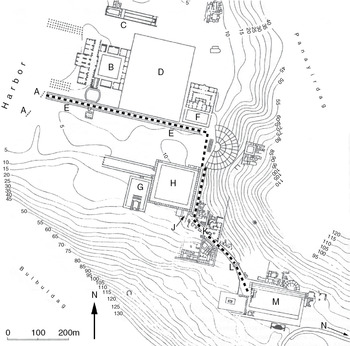
Figure 3.5 Central Ephesus in late antiquity. A: Harbor-Gate; B: Baths of Constantius; C: Church of Mary; D: palace; E: Arkadiane; F: Theater Gymnasium; G: Temple of Serapis; H: Lower Agora; J: Library of Celsus; K: Embolos; L: Gate of Herakles; M: Upper Agora; N: to Magnesian Gate. Dotted line marks course of the Arkadiane-Embolos route.
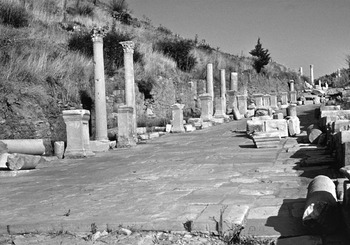
Figure 3.6 The Embolos today.
This continuous monumental armature comprising the three sections of the road and its associated structures attained unprecedented heights of architectural grandeur, beginning in the fourth century, because the governors who thenceforth controlled the funds available for building chose to make it the architectural showpiece of the city as a whole, and to recognize its de facto role as the epicenter of civic life. As Franz-Alto Bauer has shown, by the fifth century, the Arkadiane–Marble Street–Embolos axis had largely supplanted traditional civic spaces, such as the upper and lower agorai, as the venue of choice for the display of statues and inscriptions honoring the leading patrons and benefactors of the city and the late Roman state.110 City councilors and private euergetes are almost nonexistent: the dedicatees of the dozens of fourth-to-sixth-century statues and inscribed bases found among the colonnades and along the street overwhelmingly represent the emperors and members of the imperial family on the one hand, and governors and other representatives of the central administration on the other.111 This is of course to be expected, given that imperial agents were chiefly responsible for the upkeep of public architecture and infrastructure from the fourth century on.112 What is remarkable is the extent to which the colonnades and other monuments flanking the road were preferred to all other buildings in the city for the display of honorary monuments. That they were so privileged strongly suggests that there was no better place to be honored and immortalized for posterity, and thus that the city’s main processional avenue had become the heart of the urban collective, the place where the images of the emperors and their local delegates were most effectively brought before the eyes of the urban populace as a whole; where the ubiquitous presence of the imperial establishment was driven home in the constant succession of honorary inscriptions and stone faces gazing out from the shadow of the colonnades.
Beginning in the fourth century, these porticoes also became the venue in which the will of the state was made manifest in a more immediate and explicit way, in the form of the laws and edicts promulgated by the emperors and their representatives, as Denis Feissel has shown. Until the third century, the inscribed texts of such decrees were regularly displayed at the locations where the popular assembly and city council met: the theater, the odeon, the bouleuterion and the upper agora.113 After the third century, there is not a single example of an official decree posted at any of these places, a clear indication that the traditional organs of civic government were no longer responsible for their publication.114 Of the twenty-five inscribed edicts datable between the mid-fourth century (the earliest belongs to the reign of Constantius II) and the end of the sixth whose original location is well established, fourteen adorned the columns, balustrades and walls of the colonnades lining the Embolos and the Marble Street.115 Feissel’s meticulous study even suffices to trace the migration of newly inscribed acts over time: by the sixth century, when the available surfaces of the Embolos were evidently jumbled with official documents, the inscribers moved on to the adjacent stretch of the Marble Street, covering its porticoes too with a dense patchwork of documents.116 In the process, the colonnades were transformed into an indelible testament to the pull of the imperial will on the lives of the Ephesians, an archive of centuries’ worth of official pronouncements imposed on the consciousness of the masses who traversed the high street of the city on a daily basis.117
The commemorative monuments and legal texts clustered along the Marble Street and Embolos, taken in their entirety, testify eloquently to the centrality of this axis in the minds of the authorities responsible for commissioning them. The profusion of shops in the colonnades indicates that, as at so many other late antique cities, the main street was bustling with commercial activity.118 The numerous game boards inscribed in the pavements of the colonnades at Ephesus and numerous other cities reveal them as places of leisure and social gathering as well.119 The colonnades of the main street at Ephesus, in short, had become the most frequented space in the city, a development that also helps to explain why they were the preferred location for conspicuous forms of epigraphic and artistic display.
But why? Why, when emperors and their representatives became the prime movers behind the shaping of urban infrastructure at Ephesus in the fourth century, did they so assiduously maintain and embellish the architectural décor of a single colonnaded thoroughfare, which progressively subsumed so many of the commercial, commemorative and administrative functions previously more widely diffused throughout the markets, agorai, assembly halls and entertainment venues of the high imperial city?
As at the imperial capitals – Trier, Rome, Milan, Thessaloniki, Constantinople – discussed earlier, so too at Ephesus, I think the answer lies to a considerable extent in the exigencies of public ceremony. The colonnaded processional way was the conduit through which the authoritarian juggernaut of the late Roman state could most visibly and efficiently permeate the heart of the urban center. Not merely grand architectural statements punctuated by honorary monuments to the ruling establishment (which they certainly were), these streets became the main stage for the living tableaux placed before the urban populace, dutifully assembled and arrayed along the porticoes on, for example, the several occasions each year when an incoming governor either made his first adventus into the city, or returned from regular visits to the rest of the province.120 It is for these ephemeral activities, so memorable for participants and so hard for modern scholars to trace in the material record, that the rich corpus of epigraphic evidence from Ephesus is so unusually revealing.
Dozens of extant inscriptions datable from the fifth century into the seventh contain verbatim transcripts of acclamations shouted out by the crowds lining the processional route on special occasions. Like the inscribed edicts discussed earlier, they cluster almost exclusively along the Marble Street and the adjacent section of the lower Embolos. ‘Many years for Christian emperors and Greens!’ ‘Many years for pious emperors!’ ‘Many years for Heraclius and Heraclius, our god-protected lords, and for the Greens!’ ‘Heraclius and Heraclius, our god-protected lords, the new Constantines!’ ‘[Lord] help Phokas, crowned by God, and the Blues!’121 As Charlotte Roueché has said, many of these inscriptions must reproduce the wording of real chants, and they should often be understood to mark the very spot where the recorded words were uttered on one or more occasions, in addition to the identity of the speakers:122 a group of supporters of the Green faction very likely filled the colonnades of the Marble Street where their acclamations are incised, for example, just as the Blues who supported Phokas must have done along the lower Embolos where their chant appears.
A particularly eloquent evocation of a particular time and place in the ceremonial life of the city comes from an inscribed block reused in the paving of a platform leading to the northwest entrance to the theater, recently published by Roueché, which preserves the roar of the crowd as it hailed the adventus of the new proconsular governor of Asia, Phlegethius, into the city around the year 500: ‘Enter, Lord Phlegethius, into your city!’123 The position of the reused block near the intersection of the Arkadiane and the Marble Street suggests that it originated along one of the two streets, and thus on the route the entering governor would have taken on his way into the city from the harbor at the foot of the Arkadiane, where those who uttered the acclamation stood.
Another inscription preserved in situ within the colonnades of the lower embolos, just past the nymphaeum at the library of Celsus, graphically illustrates the rootedness of specific individuals in the ceremonial topography of the processional way: ‘(this is) the place (topos) of the meleparchos Andreas’ (Figure 3.7).124 Similar topos-inscriptions are attested in late antique urban contexts elsewhere in the eastern Mediterranean, where they are generally interpreted as place markers for shopkeepers and other purveyors of services, some of whom are clearly identified as such in the texts.125 In this case, however, the mention of Andreas with his official government title (meleparchos) suggests another interpretation: this is the spot where Andreas, in his capacity as a representative of the civic administration, took his place on ceremonial occasions, when the ranks of spectators arrayed themselves along the parade route according to their rank and station. Whatever the precise duties of the ‘meleparch’ (a hapax, as far as I know), it is evidently the title of a representative of the urban administration, whose official quarters are unlikely to have been sandwiched in among the shops adjacent to the place along the Marble Street where his inscription occurs. We might speculate further: the urban prefects of Constantinople were later known as eparchs; their responsibilities included oversight of all the logistical arrangements necessary for triumphal processions;126 and the tenth-century De caerimoniis aulae byzantinae places the eparch and his staff (the taxis eparchou) along the route of Justinian’s adventus of 559.127 It is thus tempting to imagine that in sixth-century Ephesus, the meleparch was involved in the organization of urban processions, whence it would be particularly appropriate that his ‘place marker’ lies along the heart of the processional route.
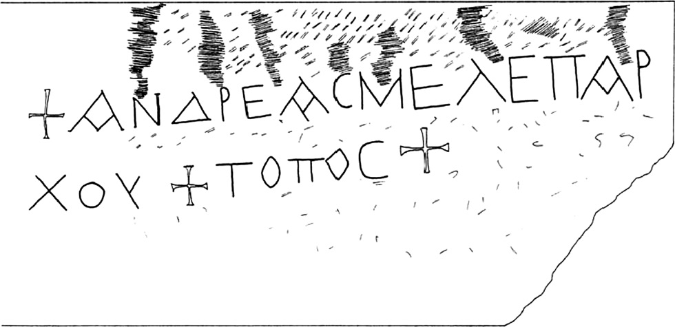
Figure 3.7 Topos-inscription of the meleparch Andreas.
The wording of the inscription is suggestively echoed in a sermon delivered by Bishop Proclus of Constantinople (434–46), whose passing reference to the protocols surrounding imperial adventus constitutes the most explicit extant testimony to the existence of what we might call stational chants:
Among the citizens of this world, when they prepare for the arrival of the temporal sovereign, they prepare the way, they crown the city gates, they decorate the city, they thoroughly prepare the royal halls, they arrange choruses of praise, each in its proper location. In these ways the entry of a temporal sovereign into any city is made manifest.128
For Proclus, particular locations along the processional route were associated with specific chants, each of which, like the meleparchos Andreas himself at Ephesus, had its proper place (kata topous). The further implication is that these chants were voiced by discrete subgroups among the urban populace, each of which had its assigned place along the Mese on those occasions when official processions passed along its colonnades.
So much is in fact clear from the literary sources, which show that at Constantinople and elsewhere, the citizenry assembled along the processional route, subdivided by rank and profession, according to a prescribed sequence. According to Libanius, when a new governor made his adventus to Antioch, his route as far as the city gate was lined by senators and ex-governors, current members of the governor’s staff (officiales), local city councilors, and then lawyers and teachers, in that order. Upon traversing the gate, he received the acclamations of the masses, doubtless including the proprietors of the shops lining the street, who thronged the colonnades along his route to the palace on the Orontes.129 When Justinian made his triumphal entrance into Constantinople after the retreat of the marauding Kotrigurs in 559, the Mese from the Capitol all the way to the palace was lined with various corps of government officials, followed by ‘the silversmiths and all the artisans, and every guild.’130 In the tenth century, shopkeepers and craftsmen still clustered according to profession along the colonnades of the Mese, which they presumably helped to decorate on ceremonial occasions.131
The example of Constantinople thus suggests also a substantial degree of interpenetration between ceremonial and commercial topography: the ranks of shops, revetted in marble and decorated by their proprietors on festive occasions, must also – at least in some cases – have been the very place where their occupants stood and voiced their acclamations to passing dignitaries. The section of the Mese called the ‘portico of the silversmiths,’132 then, would not merely have been where the silversmiths plied their trade, but also the place where they participated, as a corporate entity, in events such as the arrival of Justinian in 559, where they feature so prominently in the description preserved in the De caerimoniis.
Serious consideration might then be given to the idea that some of the many topos-inscriptions identifying individuals by name, with or without further information about their rank and profession, may relate to their placement on ceremonial occasions. The phylarch Eugraphius and the ‘most eloquent John,’ for example, whose topos-inscriptions appear on the north portico of the South Agora at Aphrodisias,133 seem more likely to have laid claim to this space in their capacity as distinguished representatives of their city than as permanent occupants of the colonnade. Similar concerns may also better explain the function of the many inscriptions located in close proximity to circles inscribed on pavements at both Ephesus and Aphrodisias, which Roueché has already been inclined to link to the positioning of spectators in attendance at public ceremonies.134 The circles, after all, have no appreciable connection to any sort of commercial activity, but would serve admirably to delineate the space to be occupied by a single, standing individual.135 A remarkable graffito found near the tetrapylon at the crossing of two main roads at Aphrodisias indeed appears to show a figure with one foot in such a circle, arms raised in what might be a gesture of acclamation.136
In any case, while the function(s) of such topos-inscriptions remains open to question, the large corpus of inscribed acclamations alone suffices to demonstrate the transformation of the Arkadiane-Marble Street-Embolos route at Ephesus into a living archive, a repository of institutional memory that ensured that the echo of the ephemeral chants voiced from its colonnades never died away. The memory of the choruses that accompanied the arrivals and other public appearances of the mighty was encoded in the fabric of the street itself, which proclaimed itself, in the voices of the people who assembled there to salute their rulers, a triumphal monument to the imperial establishment. Numerous inscribed acclamations documented at other sites, such as those present on the tetrapylon and adjacent colonnades at Aphrodisias, for example, and others by the propylon at Magnesia-on-Meander, and still others at Phrygian Hierapolis indicate that the main streets of regional centers across the eastern Mediterranean (and almost certainly beyond) experienced a similar transformation in late antiquity, for all that most of the evidence is either irretrievably lost, or awaiting identification by researchers more sensitive to its presence.137 Traces of much more ephemeral painted texts of acclamations, moreover, indicate that the extant inscriptions represent merely the tip of an immensely larger iceberg: by the sixth century, the porticoes along principal urban thoroughfares must have teemed with writing to an extent that is today almost unimaginable.138
The processional avenues that bisected the heart of the leading political and administrative centers of the late empire became, in short, the single most potent architectural manifestation of an ideal consensus between rulers and ruled. They were the stage that framed and reified the social order of the urban collective, its constituent parts hierarchically arranged – and perhaps even prescriptively oriented by inscribed place markers – festively attired, chanting pledges of allegiance to the emperor, the governor, Christian orthodoxy, Christ, Mary, their bishop, their circus-faction and/or the fortune of their city.139 When the residents of a late antique metropolis lined the colonnades along the main processional way to witness the passage of their leaders, they intermingled with the statues of generations of emperors and imperial officials, whose edicts and proclamations peppered the columns, interspersed among the acclamations voiced by the citizenry in honor of these officials on innumerable past occasions, the cumulative legacy of which was evoked by, and integrally connected with, the procession unfolding before their eyes. On all the other days of the year, the profusion of written texts and honorary monuments served as a constant reminder for all comers of those special days when the leaders of the late Roman state put the spectacle of their might and the grandeur of the institutions of government they represented most visibly on display to their assembled subjects, by day and even – perhaps to a still greater extent – by night. The brilliant lighting of the main streets at (inter alia) Antioch, Ephesus and Constantinople must only have increased their relative prominence in the cityscape, and enhanced their propensity to attract and direct the flow of passersby.140
The closely linked imperatives of commemoration, display and ceremonial praxis, in short, deserve pride of place in any attempt to explain why colonnaded streets were so privileged relative to other types of public building in late antique cities, and why, beginning in the Tetrarchic period, imperial and provincial capitals witnessed so much more building activity than the cities that remained more peripheral to the administrative apparatus of the state. Grand processional avenues proliferated in large part for their unique capacity to transform urban landscapes into scenic backdrops, majestic tableaux expressly intended to enhance the public appearances of emperors and their provincial representatives who commissioned and – directly or indirectly – funded them, and to distill the topographical profile of the places they inhabited into a narrowly circumscribed monumental itinerary.
With the growth of the Christian church, the wealthiest and most influential bishops, who themselves tended to be based in the secular capitals in which the metropolitan structure of the church was rooted,141 came almost inevitably to treat these porticated armatures as the preferred venue for the expanding battery of liturgical ceremony over which they presided, and often to annex the churches and episcopal residences they commissioned to the same streets.142 In the fifth and sixth centuries, when bishops took an increasingly active interest in the infrastructure and architectural patrimony of their cities, colonnaded streets indeed featured prominently in the list of construction projects they sponsored. Theodoret, for example, when listing the most significant architectural commissions he undertook as bishop of Cyrrhus in the second quarter of the fifth century, twice cited colonnaded streets in the first place, followed by mention of two bridges, baths and an aqueduct, all underwritten with money from church coffers.143 While the colonnades will undoubtedly have pleased the shopkeepers and passersby who frequented them, and proclaimed the bishop’s stature as a leading patron of his city, one wonders whether Theodoret did not also hope to endow the rather mediocre capital of his remote provincial see with a more distinguished architectural profile, one better suited to magnify the public appearances of a leading figure in the ecclesiastical politics and theological controversies of the age.144 Similar motives may also help to explain why other fifth- and sixth-century bishops chose to embellish their cities with street colonnades; their evident predilection for such structures surely suggests that church dignitaries, like their counterparts in the imperial administration, considered them key features of the urban landscapes they inhabited.145
The extant image that perhaps best captures the role of colonnaded streets as the vibrant center of public life in the late antique city in fact depicts a religious procession, with two bishops for protagonists. This is the ‘Trier Ivory,’ a relief panel from a reliquary produced in Constantinople, variously dated between the fifth century and the ninth (Figure 3.8).146 The event depicted on the panel has been interpreted most plausibly to represent the translation of the relics of the protomartyr Stephen, discovered near Jerusalem in 415 and triumphantly carried into Constantinople in 421, where they were installed in a new church built inside the imperial palace and dedicated to the saint whose remains it was to house.147 Two bishops mounted on a chariot at the left of the panel convey the reliquary casket toward a church that workers are scurrying to complete, before the doors of which a bejeweled woman of imperial rank waits to receive them.148 The center of the scene, however, is dominated by the profile of a two-story colonnade, packed with ranks of spectators gazing at the procession unfolding before them. Whether the colonnades represent the final section of the Mese, or the interior of the palace (or perhaps a conflation of the two),149 they are manifestly the glue that holds the image together: for the creator(s) of the casket, the physical fabric of the city condensed itself into the image of a processional way; its inhabitants to the multitude that filled both levels and the roof of the colonnade.150 In both architectural and human terms, ‘Constantinople’ is epitomized by the vision of a colonnaded street filled to bursting with beholders, without whose presence the elaborate spectacle engineered by the leaders of church and state would have been an exercise in futility.
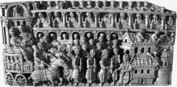
Figure 3.8 The ‘Trier Ivory.’
3.6 The Long Shadow of Constantinople, I: New Cities and Old Traditions in the Sixth-Century East
A particularly telling indicator of the enduring prominence of colonnaded streets in the minds of the leading architects of early Byzantine urban topography – again, chiefly the emperors and their provincial representatives – comes from the various cities founded ex novo as late as the sixth century, which, like Constantinople, afforded their designers extensive freedom to map out the contours of an ideal cityscape in a single, cohesively planned and executed initiative. Among the dozens(!) of examples of new cities founded in the eastern Mediterranean between the reigns of Anastasius and Justinian,151 Zenobia stands out for the quality of its extant remains, which furnish a reasonably complete picture of its basic configuration. Located along the Euphrates, on the strategically vital frontier with Sassanian Persia, the city took shape in the 530s and 540s under Justinian, though work may have begun already under Anastasius.152 The topographical imprint of the site leaves no doubt about the vision of urban infrastructure shared by the planners tasked by the central administration in Constantinople with designing it, whom Procopius names as John of Byzantium and Isidore of Miletus the younger.153 The city gravitates around two continuous, colonnaded streets that lead directly from the main gates in the city walls to a central crossing point, punctuated by a tetrapylon, where they meet at right angles (Figure 3.9).154 The principal churches and the praetorium are located in close proximity to these streets. The result was yet another urban armature made up of a continuous sequence of monumental architecture centered around colonnaded thoroughfares. All comers approaching from the outside experienced Zenobia first as an uninterrupted panorama of walls and towers, converging on the massive fortified gate through which they were required to pass; upon traversing the gates, they were funneled onto one of two wide, colonnaded streets that in turn led directly to the intramural foci of civic and ecclesiastical life. The most distinguished residents and visitors presumably need not have seen much of anything else, either during the course of their arrival/adventus or at any point thereafter.155
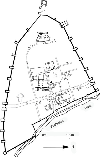
Figure 3.9 The ‘new city’ of Zenobia on the Euphrates.
Another example of sixth-century urban planning that merits particular attention is the site of Justiniana Prima, the new city erected by Justinian on the site of his birthplace at Caričin Grad, in modern-day Serbia. The tiny size of the intramural nucleus – it is some 600 meters in length, barely more than 100 meters wide over much of that extent, and encloses an area of about 7ha – belies its immense institutional prestige: by 535, Justinian had made it the capital of an independent archbishopric covering the northern half of the prefecture of Illyricum,156 and probably the seat of a praetorian prefect as well.157 The city proper is formed of three interconnected, walled nuclei perched along a narrow spit of elevated terrain: a roughly circular citadel enclosing the cathedral, baptistery, episcopal audience hall and perhaps residence; an upper city that contains at least three churches and a number of administrative buildings; and a lower city with several more churches, a bath complex and a tiny residential quarter (Figure 3.10).158 The full length and breadth of the intramural space was traversed by a total of two streets, lined along their full extent with arcaded porticoes, which converged at an oblique angle on a circular plaza in the upper city.159 The enclosed perimeter was so narrow that there was generally room for only one rank of sizeable structures in the space left between the circuit-wall and the rear of the porticoes, whence all of the principal buildings fronted one of the two streets.
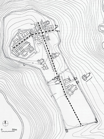
Figure 3.10 Justiniana Prima (Caričin Grad).
The walled center of the city, in other words, primarily consisted of two porticated streets, along with the single files of large, solidly built complexes – almost exclusively pertaining to government and church – visible and directly accessible from those streets.160 It was a processional itinerary with a stately façade, artfully arranged to appear larger and more ‘urban’ than it really was. Both streets made a slight bend about midway along their course, making it impossible to see how short they really were, and providing the illusion of endlessly receding arcades. From the outside, the walled profile of the city likewise appeared to extend indefinitely for anyone approaching from the south, along the principal road that connected it with the outside world: on both sides of the narrow façade of the lower city wall, comers saw only the swelling profile of the upper city and citadel, their bristling walls sweeping upward and outward along the crest of the hill, giving no sign that the enclosed space ended just past the point where the circuit reached its greatest breadth. The presence of three distinct circuits and, more to the point, three sets of gates along the main axis of traffic is also remarkable, the more so if the wall of the lower city was an original part of the city plan, as Bavant has proposed, and not a later addition.161 Regardless, anyone bound for the citadel occupied by the newly created metropolitan archbishop of northern Illyricum would have traversed three bristling city gates in the space of some 500 meters. The considerable ceremonial potential of so many gates aside, the effect was surely to make the city seem far larger, grander and more impregnable than it was, a fiction that will have been far more convincing when experienced from street level than on the modern observer’s scaled city plan.
‘Small, fortified, Christian and imperial,’162 Justiniana Prima embodies the essential characteristics of the new cities founded on orders from Constantinople in the sixth century, though it is dominated to an unparalleled extent by the profile of its porticated armature, to which the entirety of the built space inside the walls is little more than an appendage. It is unlikely to be pure coincidence that the one sixth-century city destined from its inception to attain the highest rank in the administrative hierarchy of empire and church was also the one designed to be little more – and no less – than a parade route situated in the midst of what, at first glance, might plausibly have been a great city.163 The population that filled the neighborhoods flanking the Mese at Constantinople – the epitome of a great city – was almost nonexistent within the walled confines of Justiniana Prima,164 yet from street level, the difference will hardly have been apparent; the absence of the masses was as effectively concealed by the porticoes of Justiniana Prima as was their teeming presence by those of Constantinople. In reality, the inhabitants of Justinian’s magniloquent urban gesture were almost all required to live outside the walls, where other churches, baths and traces of a defensive palisade hint at the sweep of a sprawling suburban neighborhood substantially larger than the area enclosed within the walls.165 ‘The people’ were thus very literally peripheral to the urban showpiece of the walled center, for all that they were indispensable on those occasions when the archbishops and praetorian prefects required living, chanting spectators to transform the colonnades along the processional route into a plausible facsimile of the cosmopolitan city that the dignity of their offices required them, as much as ever, to inhabit.
The ruling establishment’s continued fascination with colonnaded streets in the sixth century is equally manifest at Antioch, which Justinian was compelled to rebuild practically from scratch after it had first been devastated by a series of earthquakes and fires in the 520s, and then disastrously sacked by the Persians in 540.166 The Persians had no sooner retreated than the emperor launched a massive reconstruction effort, focused first and foremost on reconstructing the city wall and restoring the colonnades along the main intramural thoroughfares.167 Over a layer of rubble more than two meters thick in places, Justinian’s architects rebuilt the colonnaded backbone of the city’s main cardo to nearly the size and width of its predecessor, lining it with thousands of new columns along the two kilometers and more of its intramural sweep.168 Looming over the blasted ruins of a city that would never fully recover, the stately ensemble of walls and colonnades screened the devastation from view behind a plausible monumental façade, ready outwardly to proclaim the resurgence of the greatest metropolis of the Levant, and to dignify the public appearances of its governors as they struggled to reassert the authority of the central administration in the devastated province.
3.7 The Long Shadow of Constantinople, II: Ravenna
The fifth century is now quite universally recognized as a period of relative peace and prosperity, indeed of economic and demographic expansion, across most of the eastern half of the empire. Institutional change came slowly, and generally flourishing cityscapes did not transform radically, though naturally urban topography is never static.169 In the West, however, the disintegration of the empire and its partitioning into ‘barbarian’ successor kingdoms provoked more serious shifts in the ordering of government and society. The causes of the western empire’s dissolution in the fifth century continue to provoke lusty debate, and need not be rehashed here, except insofar as they relate to the condition of cities and towns.
An important point of convergence in much of the best recent work on the breakup of the western empire is, precisely, fragmentation. The western provinces, always a multicultural, multiethnic hodgepodge, embarked on diverging regional, and even micro-regional, trajectories with surprising alacrity, centrifugally spinning off from the center in Italy with a momentum that the advent of barbarian rulers does not entirely suffice to explain. To be sure, the arrival of large numbers of unsubdued peoples inside the empire, beginning with Adrianople in 378 and continuing through the collapse of the Rhine frontier ca. 406, was an historical watershed. But as (for example) Peter Brown and Guy Halsall have stressed, the really remarkable thing is how quickly Roman provincials, beginning with the landed aristocracy, reached an accommodation with Gothic, Burgundian, Frankish and Vandal rulers, recognizing in their local courts the best and most immediate source of protection and patronage available, and eagerly vying to serve there.170 While the fourth century had witnessed the rise of a mobile service aristocracy of supra-regional scope and ambitions, empowered and enriched by their imperial connections, their fifth-century descendants in North Africa, Spain, much of Gaul and eventually Italy too continued to work for local rulers in similar capacities, but in (relative) mutual isolation.171 Their horizons contracted dramatically, in a manner reminiscent of the mid-third century, when the empire fragmented into Teilreiche, in part because in difficult times provincials preferred to serve, and gain advancement from, a nearby court rather than a remote and distant emperor.
The result was a constellation of what Brown has called ‘little Romes,’ regional kingdoms under Germanic rulers that modeled themselves on imperial precedent, adopted Latin as the language of law, administration and diplomacy, and were largely staffed by native ‘Romans.’172 The royal seats of these early successor kingdoms were consistently city based, resulting in a profusion of regional capitals: Vandal Carthage; Burgundian Geneva and Lyon; Visigothic Bordeaux, Toulouse and Barcelona; sub-Roman Soissons; Frankish Cologne, Trier and Tournai, and so on.173 Further, as Halsall has suggested apropos of Spain and Gaul, the breakdown of Roman central authority and the generally unsettled conditions of the fifth century frequently made even non-‘regal’ civitates more central than ever to the ordering of local society, as the sole remaining stage upon which ambitious aristocrats and clergy could hope to act.174 As imperial control wavered and receded, in other words, the civitas was frequently all that remained. While the West was undoubtedly poorer in absolute terms than the East in the fifth century (and after), the working hypothesis that we will seek to develop, first in relation to Ravenna, and in the next chapter to a number of other places in the West, is that a substantial group of leading urban centers continued to absorb and retain a relative preponderance of the resources available, as the cream of local society and the clergy joined their new rulers in working, spending and displaying themselves there.
The continuing capacity of the urban paradigm incarnated by (inter alia) Constantinople to reach even beyond the regions under the direct control of the eastern emperors is best exemplified at Ravenna, the last imperial capital in the West, later the first city in the realm of that most Romanized (or Byzantinized) of post-Roman sovereigns, Theoderic. As the most ambitious example of urban remodeling undertaken in the Latin West in the fifth and sixth centuries, Ravenna deserves consideration at some length. It offers crucial insights into the architectural vernacular shared by its rulers and archbishops, a vocabulary of power in which central porticated thoroughfares seem to have featured as prominently as they did in the greatest cities of the eastern Mediterranean.
Following Honorius’ transfer of the imperial court from Milan to Ravenna in 402, the western scions of the Theodosian dynasty clung to Constantinople both as the buttress of their faltering hold on power, and as the urban template for the transformation of their new capital into an imperial residence worthy of comparison with the New Rome on the Bosporus.175 Honorius himself spent much of his youth in Constantinople. His sister Galla Placidia and nephew Valentinian III (western emperor 425–55) came directly to Ravenna from Constantinople in 425, following the deposition of the usurper John, effected with the help of troops dispatched from Constantinople by the young Valentinian’s cousin, Theodosius II.176 Theoderic, who perhaps did more, over the course of his long reign (493–527), to shape the monumental infrastructure of Ravenna than any other resident ruler, had likewise spent some ten years of his youth as a hostage at the imperial palace in Constantinople, an experience that manifestly shaped his vision of the magnificent capital – a sort of ‘New Constantinople,’ as it were – he wished Ravenna to be.177 Following the Byzantine conquest of the city in 540, links between Ravenna and Constantinople remained strong for the following two centuries of Byzantine rule, though building activity trailed off considerably from the later sixth century.178
With the exception of the surviving churches of fifth- and sixth-century date, our knowledge of the topographical contours of the imperial (and later regal and exarchal) capital that Ravenna became after 402 is unfortunately rather vague. Excavations, limited by the dense fabric of the modern city, offer only tantalizing glimpses of the ancient city, widely scattered and of limited extent, amongst which the most significant is the section of Theoderic’s palace excavated between 1908 and 1914, to the east of the modern Via Roma and behind the church of Sant’Apollinare Nuovo.179 The textual record is similarly lacunose, and the Liber Pontificalis of Andreas Agnellus, much the longest and most detailed source available, was compiled only in the mid-ninth century. While Agnellus’ text is replete with topographical references and descriptions of important monuments, many of the edifices he mentions were ruinous or wholly vanished in his day, and his sense of fifth- and sixth-century chronology is vague at best, and often badly confused.180
The broad outlines of Ravenna’s urban plan as it evolved in the two centuries after 402 can nonetheless be reconstructed with some confidence. The monumental framework of the new imperial capital arose to the east of the rectangular perimeter of the old city center, in a neighborhood that came to be extensively reconfigured beginning soon after the arrival of the imperial court.181 The fulcrum of the new ‘imperial’ quarter, the regio Caesarum of later sources, was the platea maior, the urban tract of the road that led through the suburb of Caesarea and on to the port of Classe, which entered the city through the Porta San Lorenzo/S. Laurentii in the new circuit of walls, themselves apparently erected during the reign of Valentinian III, though work may have begun already under Honorius and continued into the latter part of the fifth century.182
During the fifth century, a contiguous series of palace complexes arose on both sides of the road. A brief synopsis of centuries’ worth of debated issues might run something like this: when Honorius moved to Ravenna, he occupied an existing, previously extramural residential complex, possibly the residence of the praefectus classis ravennatis, located on the site of the excavated portions of Theoderic’s palace, where the existing structures of the first century AD were restored and embellished with new mosaics and opus sectile pavements around the beginning of the fifth century.183 Valentinian III is the first emperor credited in the textual record with the construction of a palace ad Lauro/ad Laureta, located to the south of the later palace of Theoderic, stretching along both sides of the platea maior toward the Porta S. Lorenzo. Agnellus, clearly relying on an earlier source, puts the murder of Odoacer at the hands of Theoderic in 493 in the palace ad lauro;184 he goes on to describe the complex at some length in a passage that contains a number of noteworthy observations: Valentinian III built a ‘lofty palace’ in a place called ad Laureta, a toponym that Agnellus associates with past triumphal victory parades based on the triumphal associations of the laurel; he goes on to say that the emperor constructed palace buildings on both sides of the platea (a point of exceptional importance, too often overlooked by modern scholars),185 and marvels at the metal clamps, evidently visible in his day, used to reinforce the masonry in these buildings, before passing on to the city walls (which ran quite close to the palace ad Laureta), which he attributes to the same emperor.186
In the early sixth century, Theoderic made extensive repairs and additions to the existing imperial palace(s), traces of which appeared in Ghirardini’s excavations of the complex north of the palace ad Laureta. Colonnades were added to the internal courtyard, new mosaics installed in the covered walkways of the quadriporticus, and an audience hall opening onto the northern flank of the colonnaded courtyard was enlarged and adorned with new floor mosaics.187 To the west, just off the platea maior, Theoderic constructed a new, Arian palatine chapel dedicated, like the fourth-century church in the palace at Constantinople, to Christ the Savior (today’s Sant’Apollinare Nuovo).188 The principal entrance to the palace lay off the platea maior in the immediate vicinity of the church, in a spot called ad Calchi (vel sim.) in later sources, a clear reference to the monumental entrance vestibule of the palace at Constantinople, the Chalke.189 Porticoes were added to the exterior façade of the palace along the platea maior, flanking the entrance, as well as to the remaining three sides of the palace.190 Thus, just as the colonnades along the final tract of the Mese at Constantinople led to the Chalke gate of the palace, so too at Ravenna, by Theoderic’s time at the latest, the principal entrance to the palace opened off the porticoes of the platea maior, which likely continued as far south as the walls at the Porta S. Lorenzo.191 With the construction of the Arian cathedral, baptistery and bishop’s palace along the west side of the platea maior, just north of the palace, the principal axis of Theoderic’s royal capital was complete: visitors arriving from the port at Classe, upon entering the Porta S. Lorenzo, found themselves invited to traverse a receding vista of porticoes, leading directly to the Calchi gate of the palace, the palatine chapel of the Savior/Sant’Apollinare Nuovo, and the Arian episcopal complex.
A second porticated avenue very probably intersected the platea maior at right angles just north of Sant’Apollinare Nuovo, along the line of the modern Via Mariani.192 This street would have connected the area of the palace with the one topographical focal point of the late antique city established before the arrival of the imperial court, the orthodox episcopal complex with its cathedral, baptistery and palace, which began to take shape under Bishop Ursus at the end of the fourth century.193 It may indeed have been the first street to be monumentalized after 402, as the connector between the twin poles of secular and ecclesiastical government, an architectonic extension of the intertwining of civic and ecclesiastical authority so essential to the vision of a Christian Roman empire championed by Theodosius I and his heirs. This road, the principal east-west axis in the late antique city, was the urban extension of the old highway leading to Rome, the Via Popilia, which entered the city through a monumental gateway erected under the emperor Claudius, itself included in the fifth-century circuit of walls and renamed – in all probability in the fifth century – the Porta Aurea, in memory of the gate in the new Theodosian land walls of Constantinople.194 From the episcopal complex, the road proceeded across the River Po on a bridge identified in later medieval sources as the ‘covered’ bridge (pons copertus),195 past the imperial mint for gold coinage (the moneta aurea) located just north of the point where it crossed the platea maior,196 on past the orthodox palatine chapel of Saint John the Evangelist, constructed during the reign of Valentinian III,197 and finally on – very possibly in a direct line – to the gate in the eastern flank of the late antique circuit called the porta palatii.198 Its porticoes, or the memory thereof, would endure for close to a millennium: in the tenth and eleventh centuries, when the road again connected the episcopal complex with the seat of civic government at the palazzo comunale, the two churches of S. Georgio de porticibus and S. Giustina in capite porticus, situated between the episcopal complex and the platea maior, still derived their popular designations from the porticoes lining the street, which remained the center of civic life in the medieval city (Figure 3.11).199
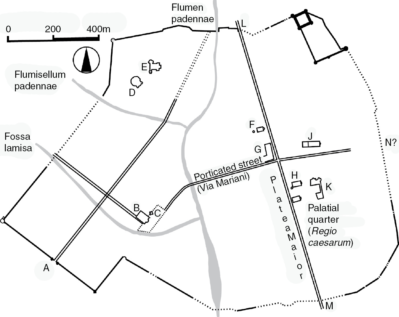
Figure 3.11 Ravenna in the sixth century. A: Porta Aurea; B: cathedral; C: orthodox baptistery and episcopal complex; D: San Vitale; E: Santa Croce; F: Arian cathedral and baptistery; G: mint; H: Sant’Apollinare Nuovo; J: S. Giovanni Evangelista; K: Theoderic’s palace (1917 excavations); L: Porta Serrata; M: Porta S. Lorenzo; N: Porta Palatii?
By the time of Theoderic’s death in 527, then, the ‘topography of power’ assembled over the 125 years since the arrival of the imperial court and the resulting elevation of Ravenna to a position of ecclesiastical and administrative preeminence was largely complete. The orthodox and Arian episcopal complexes, the sprawling palatial quarter with its associated palatine churches, royal mint and monumental entrance vestibule ad Calchi, were all directly accessible from, and linked to each other by, the converging axes of two principal streets. These streets, architectonically elevated above the rest by their flanking porticoes and connected to the principal gates in the circuit-wall, structured and defined the urban experience of Ravenna, channeling the flow of traffic and majestically framing the approaches to those buildings that most visibly and effectively proclaimed the ascendancy of their inhabitants and the institutions of church (orthodox and Arian) and government (western imperial, Gothic, and Byzantine) they championed. As at Constantinople, which the architects of Ravenna’s transformation strove so diligently to emulate, the monumental core of the city was engineered to compress the experience of a much larger, more chaotic and undoubtedly less architecturally distinguished urban conglomeration into an architectonic mise-en-scène, a city within a city that translated the language of temporal and spiritual sovereignty into the realm of built space.
And as at all of the other late antique capitals hitherto discussed, so too at Ravenna, that language of power was never more ostentatiously proclaimed, nor more integrally connected with its architectural context, than during those moments of ceremonial high drama when bishops and rulers paraded in majesty through the main streets of the city. While we know relatively little of the particulars of the ceremonies that unfolded at Ravenna, both regarding recurring events such as liturgical processions, and exceptional occasions such as adventus and victory celebrations, it is beyond doubt that Ravenna’s porticated avenues regularly hosted processions similar to those attested at, for example, Rome and Constantinople. Much of what is known comes from Agnellus, whose repeated evocations of the gates and main streets, bedecked with flowers and tapestries to receive the protagonists at the heart of defining moments in Ravenna’s storied past, reveal, if nothing else, the extent to which the decaying monumental contours of the ninth-century city continued to resound with the echoes of celebrations long past.
In his account of the negotiations that led to Attila’s decision to spare the city from destruction in ca. 450, Agnellus has Attila depart amidst general rejoicing, hailed for his clemency by the crowds lining his route: ‘Therefore the king went out from the city; [the people of Ravenna] went before him with great acclamations, with all the streets adorned and the city decorated with all manner of flowers.’200
When Maximian entered the city in 546 to be consecrated archbishop, following bitter disputes over the episcopal succession, ‘all set out in unanimity, as though one person, and opening the gates of the city, with crosses and signs and banners and praises they honorably conducted him inside this city of Ravenna; and they kissed his feet and adorned the streets of the city with various ornaments. All the buildings were crowned [bedecked with flowers], and there was public rejoicing among the contending parties.’201 Two centuries later, when a Byzantine attack was repulsed on the feast day of John and Paul, the people of Ravenna began to mark the anniversary ‘almost as though it were the holy festival of Easter, adorning the streets of the city with many tapestries, and setting out in a liturgical procession (lethaneis) to their [sc. John and Paul’s] church.’202 It might also be recalled that the site of Valentinian’s palace ad Laureta was, for Agnellus, entwined with the memory of a ‘triumphal victory once celebrated in that place,’203 an association that evokes shades of the triumphal processions that subsequently unfolded along the stretch of the platea maior – the Mese or Regia, as it were, of late antique Ravenna – in the midst of the palace.
Whatever the relationship between Agnellus’ visions of past urban ceremony and the reality they purport to represent (and he likely did draw some of his information from earlier sources that have since perished), his sense of the city’s monumental infrastructure as the stage upon which marvelous pageants were enacted is noteworthy. Agnellus’ continued inclination to perceive his surroundings as processional space, and to imaginatively layer crowns of flowers and teeming multitudes over a backdrop of city gates, streets and crumbling palaces, suggests something of how successful Ravenna’s fifth- and sixth-century rulers were in creating a physical landscape infused with the memory of their public appearances, a space capable of invoking an aura of the very epiphanies it was designed to facilitate. Agnellus, in other words, seems to have perceived the cityscape and the semiotics of power encapsulated therein in much the way Theoderic, for example – whom we know best of all Ravenna’s late antique rulers – intended it to be perceived.
Agnellus’ famous description of Theoderic’s palace indicates that the pediment of the main entrance to the palace ad Calchi was decorated with a mosaic depicting the king on horseback, armed with lance and shield, surrounded by personifications of Rome and Ravenna.204 A second equestrian portrait, this the famous statue later taken by Charlemagne to Aachen, stood in front of the entrance.205 The equally famous mosaic depiction of Ravenna at Sant’Apollinare Nuovo in fact shows what must be the Calchi, in the form of a tetrastyle entrance porch surmounted by a triangular pediment (bearing the designation PALATIUM) that once contained an equestrian portrait, surely an echo of the mosaic described by Agnellus (Plate I).206 The entrance is flanked by lower, arcaded colonnades, which may have been meant to represent – or better, to call to mind – the colonnaded façade of the palace along the plateia maior, in the midst of which the Calchi was indeed located, and which Theoderic is said to have built.207 Yet the presence of a city gate, bearing the legend CIVITAS RAVENN(AS), shown directly abutting the outermost column of the arcade on the right side of the image, demonstrates that the vignette as a whole is highly schematic.208 While its bearing on the topography of the ‘real’ city can be (and has been) endlessly debated,209 the image is sufficiently illuminating when taken purely on its own terms, as a visual compression of the elements considered most essential to the presentation of Theoderic’s capital. Seen in this light, the message seems quite clear: the palatial quarter of the city, the regio Caesarum, was to be understood, epitomized, symbolized as a city gate, opening onto an arcade – a porticated street – that in turn led directly to the entrance of the palace itself, the seat and embodiment of Theoderic’s rule, the ‘fair face of imperium,’ as Cassiodorus put it.210
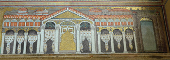
Plate I Sant’Apollinare Nuovo: nave-mosaic showing Ravenna and Theoderic’s palace.
The figures originally present in the intercolumniations of the palace façade, hands raised to acclaim Theoderic as he processed to or (more likely) from the palace,211 provide a crucial interpretive key to the mosaic’s selective distillation of urban topography: the gates, colonnaded platea and palace are the essence of the city, insofar as they constituted the monumental backdrop that underpinned the ceremonial processions of the king, and proclaimed his capital a locus of rarified temporal power. Such is precisely the sequence of monuments that Theoderic would have traversed when approaching or leaving the main entrance of his palace, via the porticated expanse of the platea maior and the gates that bracketed its northern and southern extremities, the Porta Serrata and the Porta S. Lorenzo, respectively. The placement of Theoderic’s equestrian statue, and the closely related mosaic on the façade of the Calchi, at the juncture where the arcades of the platea opened onto the entrance to the palace, marked the culmination of the triumphal itinerary, the very spot shown at the center of the urban vignette at Sant’Apollinare Nuovo, where the reproduction of the equestrian portrait on the Calchi stood in suggestive visual counterpoint to the depiction of the king in the act of processing through the city. Like Justinian’s equestrian statue in the Augusteion by the entrance to the palace at Constantinople,212 these images permanently embedded the presence of the sovereign in the heart of the most symbolically charged real estate in the city, as a constant reminder of those moments when he appeared in person among his subjects, processing amongst them on horseback in full martial regalia.
Under Theoderic, then, topography and iconography combined to transform Ravenna into a vessel for the triumphal epiphanies of the king. In constructing (or reconstructing) the exterior colonnades of the palace and thereby framing the Calchi gate and integrating its approaches into the porticoes of the platea maior, Theoderic reified the nexus between city gates, porticated street and royal dwelling that defined the architectural language of temporal rule in the early sixth century, and remade Ravenna in the image of the greatest capital of the age, Constantinople. The ultimate confirmation of the cohesiveness of the urban template envisioned by Theoderic relates not to Ravenna, however, but to Verona, the second city (along with Pavia) of the realm. Immediately after describing the porticoes erected around the palace at Ravenna, the author of the Anonymous Valesianus, Theoderic’s younger contemporary, turned to Verona, where the king ‘Likewise (my emphasis) at Verona built baths and a palace, and constructed a portico from the city-gate as far as the palace.’213 To transform Verona from a provincial center into a seat of power, what was needed was a palace, connected to a city gate by a porticated street: an urban armature, that is, fit for the arrival of a king, particularly a king as steeped in the traditions of late Roman triumphal ideology as Theoderic manifestly was.214
3.8 The Intersection of ‘Real’ and ‘Ideal’: Cities Depicted
Nowhere is the capacity of these porticated armatures to streamline and condense the physical and ideological components of the urban experience more apparent than in the extant depictions of cities produced in both the eastern and western Mediterranean in the fifth to eighth centuries. Rather than seeking to produce comprehensive plans of cities, late antique artists strove to capture the idea of ‘city’; to imply the whole through a limited canon of representational tropes centered on the features most readily associated in the minds of viewers (or patrons, or artists) with the concept of polis or civitas.215 It is thus the more noteworthy that after city walls, porticated streets are perhaps the single most distinctive feature of the cityscapes depicted in extant manuscripts and mosaics commissioned under the aegis of church and state, which is to say by the same class of patrons responsible for reshaping real cities into visual panoramas largely defined by walls and colonnades.
The most salient examples in the manuscript tradition appear in the Notitia Dignitatum, a detailed catalogue of the administrative subdivisions of the empire compiled around the beginning of the fifth century, preserved in a sixteenth-century copy that seems to reproduce quite faithfully the illustrations – at one remove – of a late antique exemplar.216 Two sections of the ‘western’ half of the document, both devoted to the commands of officials stationed in Italy, contain especially valuable illustrations. The image accompanying the list of forces at the disposition of the Comes Italiae depicts the fortified passes of the Alps, at the base of which stands a city, labeled ‘Italia,’ that stands in for the region as a whole (Plate II).217 An almost identical cityscape represents the provinces of Apulia and Calabria, joined under the governorship of the Corrector Apuliae et Calabriae.218 Both images are dominated by the profile of a hexagonal city wall, the three visible faces of which occupy approximately half of the urban vignettes as a whole. A centrally placed gate in the façade of the wall opens onto a single dominant intramural feature, an arcaded street colonnade, roofed with vivid red tiles, that departs from the gate at an oblique angle, bends sharply off to the right and continues as far as the receding profile of the wall, presumably to connect with another city gate.
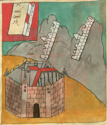
Plate II ‘Italia’ in the Notitia Dignitatum.
This remarkable compression of the urban image into a schematized ensemble of city wall, gate and colonnaded street finds its closest parallels in a number of mosaics datable between the fifth century and the seventh, all of them, interestingly enough, from Italy. The earliest are the representations of Jerusalem and Bethlehem on the spandrels of the triumphal arch at Santa Maria Maggiore at Rome, built under Pope Sixtus III (432–40). Here, too, the contours of the cityscape are defined by the profile of a hexagonal city wall, in this case bedecked with jewels in a fashion recalling the description of Celestial Jerusalem in the Book of the Apocalypse (Apoc. 10: 10–21),219 above which only the roofs of a few intramural structures are visible. The gate in the wall opens onto the receding profile of a monumental street colonnade, which joins the wall as the most visually arresting component of the scene (Plate III). The iconographical signposts used to convey all the physical and spiritual grandeur of Jerusalem and Bethlehem, in their quality as superlative embodiments of the (Christian) metropolis, boil down to an interlinked armature of city wall and colonnaded street. It is precisely the vision that would have confronted real visitors as they approached the walls and passed through the gates of the urban showpieces of late antiquity, from Constantinople, to Justiniana Prima, to – as we shall see – Jerusalem itself.
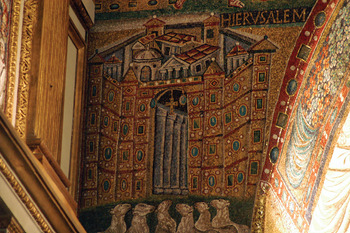
Plate III Jerusalem at Santa Maria Maggiore, Rome, ca. 440 AD.
More than two centuries later, in the oratory of S. Vincenzo, annexed to the Lateran Baptistery in the 640s under popes John IV and Theodore I, Jerusalem would again be signified by the image of a wall, a gate and a two-story colonnade (Plate IV). While the form of the cityscape – which appears in the same position on the spandrel of the triumphal arch as the example at Sta. Maria Maggiore – was doubtless inspired by earlier precedents, the fact remains that in the seventh century as much as the fifth, the essence of the Christian city was best conveyed to a Roman audience by the vision of a wall and a gate opening onto a colonnaded street.
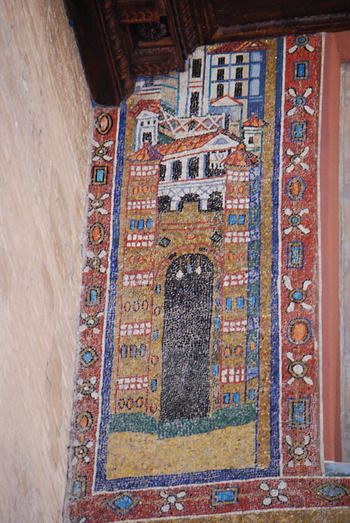
Plate IV Jerusalem in the oratory of San Vincenzo, Rome, 640s AD.
Elsewhere in Italy, there is the representation of the port city of Classe, located above the nave arcade in Theoderic’s new palace-church of Sant’Apollinare Nuovo, built adjacent to the royal palace in Ravenna in ca. 500.220 Once again, the predominant feature is the city wall, flanked on the right by a gate and on the left by a view of the port itself. Above the wall, the view of the interior of the city centers on the profile of two large, round buildings, never convincingly identified, which are connected by the unmistakable silhouette of a porticated street, the arcades and tile roof of which closely resemble the examples depicted in the Notitia Dignitatum (Plate V).221 Whatever the two buildings represent, the intramural topography of Classe is epitomized in the form of a single monumental itinerary, a colonnaded avenue linking the most imposing structures in the city, the rightmost of which may in turn be connected to the city gate by the suggestion of an additional, trabeated colonnade.
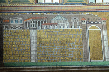
Plate V Sant’Apollinare Nuovo: nave-mosaic showing the port of Classe.
In the more famous vignette of Ravenna, located en pendant just across the nave, the colonnaded façade of Theoderic’s palatium abuts a city gate, almost certainly the Porta S. Laurentii, through which the road leading through the suburb of Caesarea and on to Classe entered the city (Plate I). Thus, the principal ceremonial axis of the city, from the Porta S. Laurentii, along the – colonnaded – platea maior and thence to the royal palace, becomes a binary pairing of gate and palace, joined by a colonnade that likely recalled the intervening street as much as the façade of the palace itself.222 Just as Theoderic’s royal capital at Ravenna was to be experienced in a stately progression of monuments linked by a colonnaded avenue, so was the adjacent port of Classe, both in mosaic and, in all probability, in reality: excavations undertaken in Classe in the 1970s and 1980s in fact uncovered a lengthy tract (running for ca. 500m) of what was almost certainly the main street leading away from the harbor; the street was repaved, provided with new sewers, and lined on both sides with porticoes supported by brick pilasters at the end of the fifth century, scant years before the execution of the mosaics at Sant’Apollinare Nuovo.223
The markedly ceremonial character of the topography represented in the images of Ravenna and Classe was further accentuated by the presence of King Theoderic and his entourage, who almost certainly appeared in both cityscapes, filling the intercolumniations of the palace façade in the depiction of Ravenna (much like the onlookers in the Constantinopolitan ‘Trier Ivory’), and silhouetted against the walls of Classe.224 The fundamental nexus between (urban) architecture, ceremony and the construction of regal legitimacy would have gone unrealized without the presence of the king, who animated the monumental armature of Ravenna and Classe with his public appearances, and maintained its architectural decorum with his patronage. Hence, following the Byzantine reconquest of the city in 540, all trace of human presence was expunged from both cityscapes, when the formerly Arian palace-church was rededicated to St. Martin of Tours under Archbishop Agnellus (ca. 557–70).225 Bereft of the ceremonial pageantry that had proclaimed the regal status of the city and the glory of its (Arian) Gothic ruler, the architectural background remained, innocuous, generic, shorn of royal pretensions, befitting the administrative seat of a peripheral and humbled province of the Byzantine empire.226
Turning to the eastern Mediterranean, the best-known depiction of a late antique cityscape in the region is undoubtedly the image of Jerusalem placed at the center of the Madaba Map Mosaic, a tesselated floor-pavement from the church of St. George in Madaba, Jordan, that depicts the geography of the Levant, from Egypt in the south to the borders of Asia Minor in the north (Plate VI).227 The centerpiece of the whole composition, the city of Jerusalem is shown larger and in considerably more detail than any of the other cities on the map. The ovoid periphery of the city wall, rendered in bird’s-eye perspective, circumscribes an ensemble of intramural topography dominated by the contours of two colonnaded streets, both of which depart from a roughly semicircular plaza located just inside the northern gate of the city, today’s Damascus Gate. The two most monumental structures depicted both connect directly to the colonnades of the central cardo: the Church of the Holy Sepulcher, placed farther south than its actual location to lie in the very center of the city, and thus the map as a whole, and Justinian’s new church of the Virgin Mary, the nea ecclesia, at the southern extremity of the same street (its dedication in 542/43 provides the terminus post for the mosaic). A third monumental structure, probably the Church of Holy Zion, lies just beyond and to the west of the point where the street terminates.228
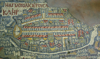
Plate VI The ‘Madaba Map Mosaic,’ detail of Jerusalem.
While the focus is clearly on the religious topography of the city, the monumental armature remains firmly in the mold of the late antique capital. A central core of colonnaded streets connects the principal gates in the city wall with the most prominent focal points of intramural life, presented in the form of three preeminent churches.229 The mosaicist’s vision indeed closely mirrors that of Justinian himself, whose most salient intervention in the topography of the real city aimed precisely at accentuating the architectonic profile of the cardo maximus, the colonnades of which were extended for hundreds of meters south of the tetrapylon at the crossing of the cardo and decumanus, as far as the façade of the newly completed Nea church.230 The principal colonnaded thoroughfare of the city, nearly doubled in length, was thenceforth bracketed by the Church of the Holy Sepulcher in the north, and Justinian’s massive new church in the south.231 These twin poles, connected by an unbroken line of colonnades, anchored the ceremonial topography of a city that, for the first time since its elevation to patriarchal rank at Chalcedon in 451, boasted an architectural centerpiece worthy of its lofty status, a space in which the patriarchs of Jerusalem could be seen to rival their colleagues in Rome, Constantinople, Antioch and Alexandria.232
The visual perspective of the mosaic is thus clearly rooted in contemporary reality, for all that the representation of Jerusalem is hardly a faithful rendering of its architecture and topography. The irregular profile of the city wall is depicted as a perfect oval; side streets are nonexistent, as is the Temple Mount; and the majority of the buildings that fill the interstices between the wall and the colonnaded streets are schematically rendered and difficult to identify. Yet the diverging profile of the two colonnaded streets shown on the map squares remarkably well with their actual configuration, still preserved in the contours of the two modern streets that faithfully follow their course, the Tariq Khan ez-Seit and the Tariq el-Wad (Figure 3.12).233 A comparative glance at Plate VI and Figure 3.12 will make this point best: by far the closest correspondence between the mosaic and the real city occurs in the profile of the two colonnaded streets, the (real) spaces that surely not coincidentally did most to define the experience of the city for those who saw it firsthand, from – naturally – street level.
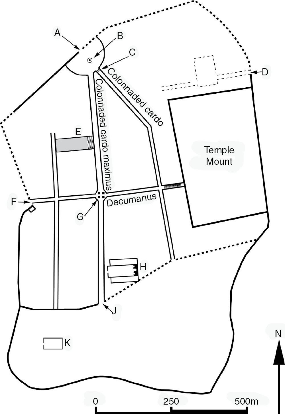
Figure 3.12 Jerusalem in late antiquity. A: Neapolis Gate (just inside modern Damascus Gate); B: open plaza and column; C: arch; D: Eastern Gate/Lion Gate; E: Holy Sepulcher complex; F: Western Gate; G: tetrapylon; H: Nea Church; J: Nea Gate; K: Church of Holy Zion.
In condensing the symbolic hallmarks of the city into an ensemble of colonnaded streets and grand churches, which corresponded in its essentials with the disposition of those monuments on the ground, the makers of the mosaic succeeded in creating a vision of Jerusalem that would have been as edifying for the residents of Madaba who saw it on the floor of the church as it would have been plausible for those who regularly traversed the city center, or participated in the processions between the three churches that anchored the liturgical topography of the city and proclaimed its unique place at the epicenter of the Christian cosmos. The monumental corridor in the midst of the city, expanded and embellished by Justinian, was simultaneously a reality susceptible to (near-) cartographic reproduction, and an ideal landscape designed to convey the essence of Jerusalem as the Christian capital par excellence.
That the archaeological map of Jerusalem on the one hand, and its features as shown on the Madaba Map on the other, correspond most closely in the positioning of the two colonnaded streets and the principal edifices attached to the central cardo is compelling testimony to what all of the ‘western’ images discussed earlier already strongly suggest: the story of the late antique metropolis is not – not always, in any case – characterized by a profound divergence between ‘image’ and ‘reality,’ a widening chasm between rosy, anachronistic literary and artistic tropes applied to ever-more squalid cityscapes, but rather by the methodical privileging of a very selective reality.234 The Madaba Map’s Jerusalem translated the material essence of the city in its ‘Justinianic’ form into an iconic panorama, a visual itinerary that closely mirrored the ensemble of gates, colonnaded avenues and churches consciously designed to define the experience of the real city. The images of Ravenna and Classe at Sant’Apollinare Nuovo functioned in much the same way, adding only the palace that proclaimed Ravenna the seat of an earthly monarch. In sum: the colonnaded streets, with their associated gates, churches and palaces, that loomed so large in the civic and religious life – and ceremonial – of the late antique capital were as real and imposing as ever in the sixth century, presenting the same exemplary urban façade that artists captured in their depictions of cities, both real and, in the case of Celestial Jerusalem, imagined.
3.9 Conclusions
Porticated streets, then, were the places where the dominant personalities in late antique society most effectively displayed themselves to the urban masses, where they acted out their status as civic and/or religious leaders, and drove home the majesty of their offices to the largest possible number of people. The unfolding of ceremonial processions brought together all members of the urban populace, framed by stately lines of receding columns, in a seamless blend of architecture and bodies that came to stand for, and in a sense to be, the city as a whole. As long as there was a processional way and people to fill it, there was in a real sense a city, regardless of the condition of the neighborhoods behind the porticoes, some still teeming with life in the sixth century (Constantinople, Ephesus, Ravenna); some ruined (Antioch); some almost nonexistent (Justiniana Prima). In condensing the architectural, commercial and symbolic essence of the city into the profile of a porticated street and its associated monuments, emperors, governors and bishops achieved a kind of architectural shorthand, a relatively economical means of preserving the appearance of capital cities and ensuring that the urban spectacle lived on.
Yet perhaps the strongest testament to just how powerful the physical, conceptual and functional legacy of these central urban itineraries ultimately became is the signs of their continuing relevance even in the seventh century and later, in a definitively post-Roman world in which the social, political and economic structures that had underpinned the flourishing of ‘classical’ urbanism had changed almost beyond recognition, as had the cities themselves, when they survived at all. It is to this changed world of the seventh to ninth centuries, the darkest of the ‘Dark Ages,’ that we now turn, in an effort to trace further the nexus between urban topography and what we might call spatial praxis – the use and experience of lived space – in the crucial transitional centuries between late antiquity and the early Middle Ages.
1 Giorgio Bejor, for example, consistently downplays the role of colonnades in the urban fabric of Western cities; with regard to Italy in late antiquity, he cites Milan as the only example of a place embellished with an important colonnaded street, thus like Mundell Mango (inf. n. 12) ignoring the important evidence for colonnaded streets in – inter alia – Rome discussed later in this chapter (Bejor Reference Bejor1999, 105–06). In recent years, many more scholars have begun to recognize their importance and ubiquity in late antiquity, though more often than not in passing: see, e.g., Crawford Reference Crawford1990, 124; Mundell Mango Reference Mundell Mango2001; Speiser in Morrisson (ed.) Reference Morrison2004, 279; Saliou Reference Saliou2005; Wickham Reference Wickham2005, 634; Tabaczek Reference Tabaczek2008, 106; Lavan Reference Lavan2009, esp. 805 and 808–09; Niewöhner Reference Niewöhner2011, 112. Lavan Reference Lavan2012 is excellent on the East, though he too paints too bleak a picture of the West after the fourth century, and the East after the early seventh; see now also Jacobs Reference Jacobs2013, 111–204.
2 Sauvaget Reference Sauvaget1934, 100.
3 Kennedy approvingly cites Sauvaget’s diagram (Kennedy Reference Kennedy1985, 12), though interestingly, Sauvaget himself proposed that the blocking of the street at Laodicea occurred only in the tenth century.
4 Saradi Reference Saradi2006, 186–208; 259–94; Sauvaget’s diagram of Laodicea is reproduced at p. 189. In a similar vein, cf. Haldon Reference Haldon1999, esp. 4 and 8–9.
5 Cf. Ward-Perkins Reference Ward-Perkins1996, 148–52 (with a highly effective critique of Kennedy’s attempt to date large-scale ‘encroachment’ on colonnaded streets to the later sixth century); also Walmsley Reference Walmsley2007, 37–39; Lavan Reference Lavan2009, esp. 808–09; Reference Lavan2012 (esp. 333–36 for a useful historiographical and methodological status quaestionis); Avni Reference Avni2011b.
6 Cf. Segal Reference Segal1997, 10; Saliou Reference Saliou2005.
7 For the use of wood in street porticoes in early imperial Gaul, v. Frakes Reference Frakes2009, 97–103 and passim.
8 Similar distinctions (often with considerably more technical nuances and categorical subdivisions) have appeared in much of the specialized literature on porticated streets: see MacDonald Reference MacDonald1986, 33 and ff.; Bejor Reference Bejor1999, 9–10; Frakes Reference Frakes2009, esp. 5–9. The streets under consideration here correspond with MacDonald’s types 5 and 6: ‘covered porticoes ... carried on columns or piers and interposed between the pavement and the buildings ... (forming) a continuous colonnade at least several blocks long,’ on one or both sides of the street (p. 33).
9 Bejor Reference Bejor1999, 10–15; Segal Reference Segal1997, 9.
10 See generally MacDonald Reference MacDonald1986, 33–51; Segal Reference Segal1997, 5–54; Bejor Reference Bejor1999, passim; for the underappreciated colonnades in northwest Europe, see Lehmann-Hartleben Reference Lehmann-Hartleben1929, 2109–10; Bejor Reference Bejor1999, 89–91; Byhet Reference Byhet and Hanoune2007, 427–28. On Lincoln, see Wacher Reference Wacher1995, 120–37; Reims: Byhet Reference Byhet and Hanoune2007, 433; Italica: Bejor Reference Bejor1999, 89. In addition to true colonnades, many more Western cities featured street porticoes of varying degrees of monumentality supported by pillars in masonry or wood: for numerous examples in Gaul, see Byhet Reference Byhet and Bedon2001–02, Reference Byhet and Hanoune2007; Frakes Reference Frakes2009.
11 Cf. Bejor Reference Bejor1999, 104–05; Saradi Reference Saradi2006, 291.
12 Mundell Mango Reference Mundell Mango2001, 29.
13 See, e.g., E. La Rocca Reference La Rocca1984, 65ff., with prior bibliography; remnants of what must be the arcades of this porticus triumphi remain visible in the Forum Boarium, near the church of S. Nicola in Carcere (Coarelli Reference Coarelli1988, 394–97).
14 Tacitus, Annales 15.43, stressing both the utility (utilitas) of the new streets in preventing future catastrophic fires, and their impressive appearance (decor); cf. MacDonald Reference MacDonald1982, 25–31; Bejor Reference Bejor1999, 9–10, 82–83.
15 Suetonius, Ner. 31; MacDonald Reference MacDonald1982, 31ff.
16 Van Deman Reference Van Deman1923, esp. 415–19; generally on the location and evolution of the Sacra Via, Coarelli Reference Coarelli1986, esp. 11–26.
17 Dey Reference Dey2011, 174–80, 304–09.
18 As the bridge cannot plausibly be connected with any of the bridges mentioned in the exhaustive list given in the Regionary Catalogues of the early fourth century, it was almost certainly defunct by this point. The terminus ante is given by the earlier of the two lists, the Curiosum, which is best dated to the early part of Constantine’s reign at the latest (Codice topografico della città di Roma, vol. I, 66ff.).
19 Cf. E. La Rocca Reference La Rocca1984, 65–66.
20 The matter is discussed in detail in Dey Reference Dey2011, Appendix D.
21 CIL 6, 1184: Imperatores caesares ddd nnn Gratianus Valentinianus et Theodosius pii felices semper Auggg arcum ad concludendum opus omne porticuum maximarum aeterni nominis sui pecunia propria fieri ornariq. iusserunt. The inscription is transcribed in the so-called Einsiedeln Itineraries, a ninth-century compilation of guided walking tours through the city of Rome.
22 One telling indicator of the new centrality of the Pons Aelius comes from an allusion in the Peristephanon of Prudentius (written ca. 400), for whom ‘Hadrian’s bridge’ was the preferred (and almost certainly only) means of access to St. Peter’s from the Campus Martius: ibimus ulterius qua fert via pontis Hadriani (Peristephanon 12.61); in one of Augustine’s newly discovered sermons, the emperor Honorius clearly crossed the Tiber via the same bridge on his way to St. Peter’s in 404 (see Dolbeau Reference Augustine and Dolbeau1996, 266).
23 Procop. BG 1.22.21; generally on the topography and ceremonial importance of the route to St. Peter’s, see Liverani Reference Liverani2007. Liverani (Reference Liverani2007, 93) imagines that the extramural colonnade was built rather later, ca. 500, but acknowledges that the proposal is – necessarily given the state of the evidence – purely speculative.
24 St. Paul’s: Procopius, BG 2.4.9; S. Lorenzo: Liber Pontificalis I, 396 and 508.
25 In 383–84, we see Symmachus in his capacity as praefectus urbi of Rome communicating with the reigning emperors Valentinian II, Theodosius and Arcadius, who were responsible for allocating the funds for the new construction; in practice, Valentinian II, from his capital at Milan, will have been the prime mover in the new project: see Collectio Avellana, 3 (CSEL 35, pp. 46–47), with Chastagnol Reference Chastagnol1960, 349–50.
26 See Saghy Reference Saghy2000, with extensive prior bibliography; cf. also Pietri Reference Pietri1961, esp. 303–04.
27 Baldovin Reference Baldovin1987, 143–66, esp. 155; Chavasse Reference Chavasse1993, 231–46.
28 Cf. Dey Reference Dey2011, 225–28; Fiocchi Nicolai Reference Fiocchi Nicolai and Ermini2000, 229.
29 Liber Pontificalis I, 507–08.
30 Caporusso Reference Caporusso1991, 251–57.
31 Bovini Reference Bovini1961; Lewis Reference Lewis1969a; ead. Reference Lewis1969b, 83–92; Krautheimer Reference Krautheimer1983, 80.
32 E.g., Lewis Reference Lewis1969b, 92: ‘Indeed, the large-scale demolition of tombs to clear the site for construction would suggest that the prestige of the imperial porticoed street may have been the overriding factor in Ambrose’s choice of this spot, not its function as a Christian burial ground’; cf. Lewis Reference Lewis1969a, 217–18.
33 Cf. McLynn Reference McLynn1994, 232. The other extramural foundations are the Basilica Ambrosiana-Basilica Martyrum-S. Ambrogio; the Basilica Virginum-S. Simpliciano; and – perhaps – the vanished Basilica Salvatoris, attested in the later Middle Ages as S. Dionigi: on the case for S. Dionigi as an Ambrosian foundation, v. Cattaneo Reference Cattaneo1974; on the other suburban churches, Krautheimer Reference Krautheimer1983, 77ff.; McLynn Reference McLynn1994, 226–37. The relative prestige of the Basilica Apostolorum is amply attested by the outstanding importance of the relics it was built to house, from which it took its name, for all that these may have been brandea (contact relics) rather than physical remains; for diverse views on the nature, provenance and importance of the relics, v. Lewis Reference Lewis1969b, 93; Krautheimer Reference Krautheimer1983, 80; McLynn Reference McLynn1994, 230–32.
34 Lewis Reference Lewis1969a, 209; Krautheimer Reference Krautheimer1983, 80; McLynn Reference McLynn1994, 232. On the location and dating of the Apostoleion in Constantinople, see later in this chapter.
35 TCCG Vol. 1, 24–25.
36 It is noteworthy that the Basilica Apostolorum was also the Ambrosian foundation most closely associated with high-ranking members of the imperial court. Leading members of the secular élites were buried there; and in 395, Stilicho’s wife, Serena, sponsored the new pavement of Libyan marble installed around the relics of Nazarius, including in her dedicatory inscription a prayer for Stilicho’s return from campaigning (Lewis Reference Lewis1969b, 96–97; McLynn Reference McLynn1994, 363–64). As McLynn has seen so well, the Basilica Apostolorum, privileged as it was by its relationship to the main adventus-route, was in effect the state church of the city, ‘a place within Christian Milan for the newly arrived imperial entourage’ (Reference McLynn1994, 232).
37 The date is given by the Martyrologium Hieronymianum, which reports the arrival of the relics at the Basilica Apostolorum on May 9 thus (AS Nov. 2.2, p. 241): Mediolani de ingressu reliquiarum apostolorum Iohannis, Andreae et Thomae in basilicam ad portam Romanam.
38 Ambrose, Ep. 77.1, with McLynn Reference McLynn1994, 209–15.
39 Ambrose, Ep. 77.2ff., with Dufraigne Reference Dufraigne1994, 301–02.
40 For Ambrose’s biographer Paulinus, whose account establishes the date of the translation shortly after the death of Theodosius in 395, the church is again inseparable from its flanking street, the ‘Romana’ (Vita S. Amb. 32): Quo in tempore sancti Nazarii martyris corporis, quod erat in horto positum extra civitatem, levatum ad basilica apostolorum, quae est in Romana, transtulit. Cf. McLynn Reference McLynn1994, 363–64.
41 Dufraigne Reference Dufraigne1994, 299; Klein Reference Klein and Bauer2006, 82–83.
42 Sozomen, HE 7.21.4–9; Chronicon Paschale, p. 564.
44 Chronicon Paschale, pp. 570–71; the palace is named by Procopius (De aed. 1.11.16) in his account of Justinian’s reconstruction of the complex.
45 The arrival of these relics at the church is (probably) the subject of the famous relief on the ‘Trier Ivory,’ most plausibly interpreted to represent the emperor’s sister Pulcheria Augusta awaiting their arrival before the entrance to the still-unfinished church: see n. 146. More broadly on relic translations into the capital and its environs under Theodosius II, v. Klein Reference Klein and Bauer2006, 84–86.
46 McLynn Reference McLynn1994, 363–64. The inscription reads: Qua sinuata cavo consurgunt tecta regressu / sacrataque crucis flectitur orbe caput / Nazarius vitae immaculabilis integer artus / conditur; exultat hunc tumuli esse locum; / quem pius Ambrosius signavit imagine Christi / marmoribus Libycis fida Serena polit; / coniugis ut reditu Stiliconis laeta fruatur, / Germanisque suis pignoribus propriis (transcribed in Lewis Reference Lewis1969b, n. 47).
47 There are of course exceptions to the rule of collaboration between emperors and bishops, notably the violent conflict between the partisans of Arcadius and John Chrysostom that led to the deposition of the latter, on which see recently Andrade Reference Andrade2010.
48 Victricius of Rouen, for example, is particularly explicit in comparing the arrival of relics to the adventus of emperors: v. De laude sanctorum 12, 15–42 and passim, with Dufraigne Reference Dufraigne1994, 303–07; cf. also Clark Reference Clark2003.
49 According to Ambrose, the relics of Felix, Nabor and Victor, soldiers martyred in 304, were conveyed in triumph into Milan during the episcopate of Maternus (316–28), borne on a ‘triumphal cart’ (Hymn. 10, 29–32): sed reddiderunt hostias rapti quadrigis corpora revecti in ora principum plaustri triumphalis modo. For the use of similar vehicles (often described with the traditional term currus) in the adventus of fourth-century emperors, McCormick Reference McCormick1986, 87–88.
50 Generally on the components of the Constantinian building program outlined in the following section, see Krautheimer Reference Krautheimer1983, 46–56; Mango Reference Mango1985, 23–36; Bauer Reference Bauer2001, 30–32; Reference Bauer and Mertens2008, 195.
51 Dagron Reference Dagron1974, 43–47.
52 Bauer Reference Bassett1996, 228–33; on the numerous questions that remain about the Capitol and its sculptural decoration, Meyer Reference Meyer2002, 161–68.
53 Bauer Reference Bassett1996, 167–87; Meyer Reference Meyer2002, 93–97; on the statue, see esp. Bardill Reference Bardill2012, 28–36; 104–09.
54 Mango 1959, 48–49, 78–81; Müller-Wiener Reference Muller-Wiener1977, 216–18.
55 The colonnades lining the Mese between the forum and the palace are singled out for mention by Malalas, Chron. 13.8 (Dindorf 321), and the Chronicon Paschale, p. 528, both of which state that this portion of the Mese was called the Regia.
56 On the Chalke, see esp. Mango 1959.
57 For the Augusteion and its surrounding monuments, Mango 1959, 42–72; Bauer Reference Bassett1996, 148–67; on Hagia Sophia, Müller-Wiener Reference Muller-Wiener1977, 84–96; on the episcopal palace, Mango 1959.
58 Müller-Wiener Reference Muller-Wiener1977, 112–17.
59 Bauer Reference Bassett1996, 148–67; on the hippodrome and the baths of Zeuxippos, see also Müller-Wiener Reference Muller-Wiener1977, 64–71 and 51, respectively.
60 Useful overviews of the palace include Müller-Wiener Reference Muller-Wiener1977, 229–37; Kostenec Reference Kostenec2004.
61 On the connection between the residential wing of the palace and the kathisma on the eastern (palace) side of the hippodrome, see Dagron Reference Dagron1974, 36, 320–47; Müller-Wiener Reference Muller-Wiener1977, 64–65; on the baths, which communicated with the palace via a side door in the fourth century, see Mango 1959, 40.
62 Mango 1959, 85–92.
63 Par. 56; see Cameron and Herrin Reference Cameron and Herrin1984, 131–33.
64 Bauer Reference Bauer2001, 33–34; cf. also Dagron Reference Dagron1974, 37–42.
65 The best description of the ceremony is given by John Malalas (Chron. 13.8 [Dindorf 321–22]); see also the very similar account in the Chronicon Paschale, pp. 528–30.
66 Bauer Reference Bauer2001, 35; see also Bardill Reference Bardill2012, 151–58.
67 On all of these complexes, in addition to the individual entries in Müller-Wiener Reference Muller-Wiener1977 (esp. 250–65), see Mango Reference Mango1985, 37–50; Reference Mango2000; Bauer Reference Bassett1996, 187–212; Reference Bauer2001, 37–40; Meyer Reference Meyer2002, 105–74.
68 Bardill Reference Bardill1999 (who thinks it a triumphal arch originally built for Theodosius I, subsequently incorporated into the walls of Theodosius II); Mango Reference Mango2000.
69 Dagron Reference Dagron1974, 92–102; Bauer Reference Bauer and Mertens2008, 197 and passim.
70 On the problem of the precise location of the Apostoleion and its relationship to the northern branch of the Mese, v. Berger Reference Berger1997, 398–402.
71 Grierson Reference Grierson1962.
72 With regard to the date of the Apostoleion and its relationship to the mausoleum, I follow Mango Reference Mango1990 (contra, e.g., Krautheimer Reference Krautheimer1983, 56–60), who makes a convincing case that Constantine erected only the mausoleum (albeit as a shrine to the twelve apostles and above all to himself in the guise of the thirteenth apostle), leaving it to Constantius II to commission the cruciform church, in part to alleviate the embarrassing theological problems provoked by Constantine’s subordination of the cenotaphs of the apostles to his own tomb in the mausoleum. This would then be the structure said in the Chronicon Paschale (p. 559) to have been dedicated in 370.
73 See n. 34.
74 Bauer Reference Bassett1996, 213–15.
75 Bauer Reference Bassett1996, 379–83; Bejor Reference Bejor1999, 101–06; Berger Reference Berger2000; Mundell Mango Reference Mundell Mango2001, 30–33 and 44–46. More generally on the layout of the street grid in Constantinople in the first century following its foundation, v. Berger Reference Berger1997, 395–411.
76 Cf. Bauer Reference Bassett1996, 385–88. The stretch of the Mese between Hagia Sophia and the forum of Constantine was by far the most frequently traversed of all the routes in the city; fully forty-six of the sixty-eight processions mentioned in the tenth-century Typikon of Hagia Sophia passed through the latter: see Baldovin Reference Baldovin1987, 197, 212.
77 See, e.g., Bauer Reference Bauer and Mertens2008, esp. 203–05.
78 Bauer Reference Bassett1996, 383–85; Reference Bauer and Mertens2008, 205–06; Diefenbach Reference Diefenbach and Warland2002; Klein Reference Klein and Bauer2006; cf. also Baldovin Reference Baldovin1987, 185–89, 211–12. For the sources relating to the translations of Samuel and Stephen, see nn. 43–45. On the return of Chrysostom’s remains, which were deposited in the Apostoleion with the participation of both Theodosius II and the Patriarch Proclus, see Socrates, HE 7.45; cf. Marcellinus Comes, Chron. a. 438 (ed. Mommsen, p. 79).
79 de s. hieromartyre Phoca, PG 50, col. 700: Λαμπρὰ γέγονεν ἡμῖν χθὲς ἡ πόλις, λαμπρὰ καὶ περιφανὴς, οὖκ ἐπειδὴ κίονας εἶχεν, αλλ᾽ ἐπειδὴ μάρτυρα πομπεύοντα ἀπὸ Πόντου πρὸς ἡμᾶς παραγενόμενον. For Chrysostom’s similar take on street colonnades at Antioch, see n. 91.
80 ‘Indeed the emperors sing choruses together with us. What indulgence [for absenting themselves from the celebration], then, should private individuals receive, when the emperor and empress leave the royal palace, and seat themselves at the sepulcher of the martyr? So wonderful is the virtue of the martyrs that it enmeshes not only private people, but also those who wear the diadem’ (Ibid.).
81 Not. Urb. Const. 8, lines 2–9: Regio septima in conparatione superioris planior, quamvis et ipsa circa lateris sui extremitatem habeatur a mare declinior. Haec a parte dextera columnae Constantini usque ad forum Theodosii continuis extensa porticibus et de latere aliis quoque pari ratione porrectis, usque ad mare velut se ipsam inclinat et ita deducitur. Cf. Berger Reference Berger1997, 365–67.
82 On the literary and archaeological evidence for the non-monumental quarters of the city, see Dark Reference Dark2004.
83 Ordo Nobilium Urbium 7, lines 9–10.
84 Tatius’ erotic novel Leukippe and Kleitophon is now generally assigned a date in the second century: see the OCD, 3rd ed., s.v. Achilles Tatius (2). Upon arriving in Alexandria after a three-day journey, Tatius’ hero Kleitophon proclaims (5.1): ‘I entered it (Alexandria) by the Sun Gate, as it is called, and was instantly struck by the splendid beauty of the city, which filled my eyes with delight. From the Sun Gate to the Moon Gate – these are the guardian divinities of the entrances – led a straight double row of columns, about the middle of which lies the open part of the town, and in it so many streets that walking in them you would fancy yourself abroad while still at home. Going a few stades further, I came to the quarter called after Alexander, where I saw a second town; the splendor of this was cut into squares, for there was a row of columns intersected by another as long at right angles’ (Trans. S. Gaselee, Achilles Tatius, Loeb Classical Library [London, 1917], p. 237, slightly adapted); cf. Haas Reference Haas1997, 29–31.
85 Eusebius, Mart. Pal. 9.12: αἰθρία ἦν καὶ λαμπρὸς ἀὴρ καὶ τοῦ περιέχοντος κατάστασις εὐδινοτάτη εἶτα ἀθρόως τῶν ἀνὰ τὴν πόλιν κιόνων οἳ τὰς δημοσίας ὑπήρειδον στοάς, δακρύων τινὰ τρόπον οἳ πλείους σταλαγμοὺς ἀπέσταζον, ἀγοραί τε καὶ πλατεῖαι, μηδεμιᾶς ψεκάδος ἐξ ἀέρος γεγενημένης, οὐκ οἶδ᾽ ὁπόθεν ὕδατι ῥανθεῖσαι καθυγραίνοντο, cf. Sivan Reference Shear2008, 322; Holum 2009, 199.
86 Ed. Rougé, p. 61: Quae dispositione valde gloriosissima constat, etenim ordinem arborum habet in vicos aequales (Rougé, p. 19, dates the text to 359).
87 Sup. n. 79.
88 See Downey Reference Downey1959.
89 Trans. Downey Reference Downey1959, 673–75.
90 Cf. Lassus Reference Lassus1972; Pullan Reference Pullan1999.
91 Hom. 17 (PG 49, col. 176): Ἀλγεῖς ὅτι τὸ τῆς πόλεως ἀξίωμα ἀφῄρηται; μάθε τί ποτέ ἐστι τῆς πόλεως ἀξίωμα, καὶ τότε εἴσῃ σαφῶς, ὅτι ἐὰν οἱ οἰκοῦντες αὐτὸ μὴ προδῶσιν, οὐδεὶς ἕτερος ἀφελέσθαι δυνήσεται ἀξίωμα πόλεως. Οὐ τὸ μητρόπολιν εἶναι, οὐδὲ τὸ μέγεθος ἔχειν καὶ κάλλος οἰκοδομημάτων, οὐδὲ τὸ πολλοὺς κίονας, καὶ στοὰς εὐρείας καὶ περιπάτους, οὐδὲ τὸ πρὸ τῶν ἄλλων ἀναγορεύσθαι πόλεων, ἀλλ᾽ ἡ τῶν ἐνοικούντων ἀρετὴ καὶ εὐσέβεια (emphasis mine). See also ibid., col. 178: οὐδεν γὰρ ἡμᾶς ὠφελῆσαι δυνήσεται κατὰ τὴν ἡμέραν ἐκείνην, τὸ μητρόπολιν οἰκεῖν, και στοὰς ἔχουσαν εὐρείας καὶ τὰ ἄλλα ἀξιώματα τὰ τοιαῦτα. (‘It will be of no help to us on that day [of judgment], that we live in a metropolis with wide porticoes and other such adornments.’) On the strong probability that Libanius taught Chrysostom in his youth, see J. N. D. Kelly Reference Kelly1995, 6–8. For the ‘affair of the statues,’ see also Libanius, Or. 19–23.
92 Trans. Downey Reference Downey1959, 675–76.
93 Reference DowneyIbid., 679.
94 See n. 2. Cf. Saliou Reference Saliou2005, esp. 210–11, 220–21.
95 And, for that matter, in the West too – see, e.g., Byhet Reference Byhet and Bedon2001–02 on Gallic cities, and esp. 17–18 on Flavian Rome.
96 Liebeschuetz Reference Liebeschuetz1972, 208–19; cf. Saliou Reference Saliou2005, 212–14.
97 See esp. Liebeschuetz Reference Liebeschuetz1972, 132–36 (from whose thorough perusal of the Libanian corpus the following citations derive). Modestus, governor in 358–59, erected a sumptuous new street colonnade with the compulsory labor of the urban collegia, whose members were taxed nearly to the breaking point by the demands of the project, among them the need to ferry columns from as far away as Seleucia, according to Libanius (who discussed this project in more detail than any other); see Ep. 196 and 242 (both of 358–59); and 617 (of 361). Among the building projects of the praefectus urbi Proculus, Libanius mentions only work on a theater, a bath complex and – again – the paving and colonnades of streets (Or. 10; Ep. 852).
98 Libanius in fact admonishes Modestus to take care lest his stoa become the subject of vitriol rather than praise in the future (Ep. 617.3; its prestige value is also a prominent theme in Ep. 196).
99 Libanius, Or. 46.44.
100 Libanius, Or. 33.34.
101 E.g., Petra (Fiema Reference Fiema2008); Scythopolis (Segal Reference Segal1997, 28–30; Agady et al. Reference Agady, Arazi, Arubas, Hadad, Khamis, Tsafrir and Rutgers2002); Sardis (Crawford Reference Crawford1990; Harris Reference Harris2004); for further examples, see the useful overview in Crawford Reference Crawford1990, 107–25, and especially Lavan Reference Lavan2012.
102 CJ 8.10.12.6a–b.
103 Ibid., 8.10.12.6b–c: ὥστε κάλλος μὲν διδόναι τῇ πόλει, ψυχαγωγὴν δὲ τοῖς βαδίζουσι. For other examples of the (voluminous) laws issued in connection with the regulation of private occupation of colonnades in Constantinople, see CTh 15.1.39 (of 398); 15.1.50 (of 412); 15.1.52 (of 424); 15.1.53 (of 425); see also Patlagean Reference Patlagean1977, 59–61; Ward-Perkins Reference Ward-Perkins1996, 152; Saliou Reference Saliou2005, 214–18; Saradi Reference Saradi2006, 194.
104 CJ 8.10.12.6c. Cf. generally Mundell Mango Reference Mundell Mango2000, esp. 194–97.
105 Bauer Reference Bassett1996, 278–79.
106 Foss Reference Foss1979, 47–84; Bauer Reference Bassett1996, 269–99; cf. Scherrer Reference Scherrer and Koester1995, 20–23.
107 Bauer Reference Bassett1996, 271–74.
108 Bauer 278–93; see also the contributions of Roueché, Auinger, Quatember et al., Iro et al. and Schindel in Ladstätter (ed.) Reference Ladstätter2009, all of which make it clear that the Embolos rapidly lost its monumental character in ca. 616, very possibly in connection with the Persian invasion of western Asia Minor in that year; generally on 616 and its aftermath at Ephesus, see also Foss Reference Foss1979, 103–15.
109 Bauer Reference Bassett1996, 278–93.
110 Reference BassettIbid., esp. 296ff.; Aurenhammer and Sokolicek Reference Aurenhammer and Sokolicek2011, esp. 59, 65–66.
111 Bauer Reference Bassett1996, 284–90, 297; Roueché Reference Roueché and Jeffreys2006, 251–52; ead. Reference Roueché2009; cf. also Auinger Reference Auinger2009.
112 The same trend is evident at, for example, Aphrodisias, where from the Tetrarchic period on, honorary statues and inscriptions (including those that relate specifically to building activities) focus almost entirely on members of the imperial establishment, while local city councilors largely vanish: see esp. Smith Reference Smith1999; also Smith Reference Smith2002, 146–48; Roueché Reference Roueché2004, passim.
113 Feissel Reference Feissel, Pillinger, Kresten, Krinzinger and Russo1999, 122–23.
117 Antioch provides a suggestive parallel: there, official proclamations seem to have been displayed on the Tetrapylon of the Elephants, where Julian posted his Misopogon (Saliou Reference Saliou2009, 247–48); Ausonius likewise depicts the colonnades at Milan as the place where imperial decrees were posted in his speech of thanks for the consulship of 379 (Gratiarum Actio, 10.50): has ego litteras tuas si in omnibus pilis atque porticibus, unde de plano legi possint, instar edicti pendere mandavero, nonne tot statuis honorabor, quot fuerint paginae libellorum?
118 Crawford Reference Crawford1990, 108–11.
119 The extant examples found at Ephesus are heavily concentrated along the Arkadiane: see the catalogue in Schädler Reference Schädler1998, nos. 2–4, 11 (and passim for a useful catalogue of game boards from other sites in Asia Minor). For late antique game boards on the main colonnaded street at Sagalassos, see Lavan Reference Lavan2008, 207; for additional exemplars at Aphrodisias, see Roueché Reference Roueché and Finkel2007.
120 Roueché Reference Roueché and Jeffreys2006, 252; ead. Reference Roueché2009, 158; Ladstätter and Pülz Reference Ladstätter and Pülz2007, 402–04.
121 Roueché Reference Roueché, Friesinger and Krinzinger1999a, respectively catalogue nos. 1a: Χριcτιανῶν βαcιλέων κ(αι) Πραcίνων πολλὰ τὰ ἔτη; 1b: εὐσεβων βαcιλέων πολλὰ τὰ ἔτη; 2: Ἡρακλήου καὶ ῾Ηρακλήου τῶν θεωφυλάκτων ἡμῶν δεσποτῶν καὶ τῶν Πραcίνων πολλὰ τὰ ἔτη; 6: Ἡρακλήου καὶ ῾Ηρακλήου τῶν νέων Κονςταντίνων τῶν θεοφυλάκτων ἡμῶν δεcποτῶν; 11: Φωκᾷ τῷ θεωcτεφῇ ἡμῶν δεcπ(οτῇ) καὶ Βενέτοις [Κ(ύρι)ε βο]ῇθcον. Inscriptions 1a, 1b, 2 and 6 come from the Marble Street, 11 from the lower Embolos.
122 Roueché Reference Roueché, Friesinger and Krinzinger1999a, esp. 162; ead. Reference Roueché1984, 196 and passim (the latter on the remarkable series of acclamations honoring the clarissimus Albinus from the columns of the west stoa of the agora at Aphrodisias, which he restored in – probably – the first half of the sixth century).
123 ἔνβα κύρι Φλεγέθι [ἐc] τὴν πόλιν c[ου]: see Roueché Reference Roueché, Scherrer, Taeuber and Thür1999b.
124 I.Eph. 1374.2: Ἀνδρέαc μελεπάρχου τόπος. I thank Franz Alto Bauer for calling my attention to this inscription, and for providing a drawing of the text, which allows the Ἀνδρέα given in the I.Eph. transcription to be amended to Ἀνδρέαc. A second graffito on the same stone invoked divine aid for the same Andreas (I.Eph 1374.1): κύριε βοήθηcον το δούλο cου Ἀνδρέᾳ. The editors wonder if this individual is perhaps the proconsul of the same name attested in I.Eph. 1301 and 1355, an intriguing possibility.
125 For such inscriptions on the main colonnaded avenues at Sagalassos and Perge, see Lavan Reference Lavan2008, 206–07; one inscription from the principal thoroughfare at Perge marks, for example, the topos of an eating establishment (thermopolium; Reference Lavanibid., n. 42); for the numerous topos-inscriptions from Aphrodisias, see Roueché Reference Roueché2004, nos. 187–211; nos. 189–91 name a trouser maker, cloakroom attendant and barber, respectively; other examples occur at the market gate in Miletus (Maischberger Reference Maischberger and Dally2009, 114–15); for additional examples, see Lavan Reference Lavan2012, 338–40.
126 McCormick Reference McCormick1986, 204–05 and passim.
127 De caer. 498, 3–4; on Justinian’s adventus of 559, see later in this chapter; the passage is quoted in full at n. 130.
128 Proclus, Or. 9 (In ramos palmarum; PG 65, col. 773a): Ἐν κοσμικοῖς πολίταις, ὅτε προσκαίρου βασιλέως εἵσοδον περιμένουσι, τὴν ὁδὸν ὁμαλίζουσι, τὰ προπύλαια στεφανοῦσι, τὴν πόλιν ἐξαλλάπτουσι, τὰς βασιλικὰς αὐλὰς πανταχόθεν καθαίρουσι, χοροὺς ἐγκωμίων κατὰ τόπους συνφαίνουσιν. ἐν τούτοις γὰρ ἡ τοῦ προσκαίρου βασιλέως εἴς τινα πόλιν εἴσοδος γνωρίζεται. Cf. McCormick Reference McCormick1986, 212.
129 Or. 56, with Liebeschuetz Reference Liebeschuetz1972, 209 and ff.
130 De caer. 497.20–498, 6: ὡς δὲ εἰσῆλθεν (Justinian) εἰς τὴν μέσην, ὑπήντησαν δομέστικοι πρωτίκτορες, αἱ ἑπτα σχολαὶ καὶ μετ᾽ αὐτους τριβοῦνοι καὶ κόμητες, πάντες μετὰ λευκῶν χλαμιδίων καὶ κηρῶν δεξιὰ καὶ ἀριστερὰ ἱστάμενοι, καὶ μετ᾽αὐτους μαγιστριανοὶ, φαβρικήσιοι, τάξις τῶν ἐπάρχων καὶ τοῦ ἐπάρχου, ἀργυροπρᾶται καὶ πάντες πραγματευταὶ, καὶ πᾶν σύστημα, καὶ ἁπλως ἀπὸ τοῦ καπιτωλίου μέχρι τῆς χαλκῆς τοῦ παλατίου πάντα ἐπεπλήρωτο.
131 McCormick Reference McCormick1986, 206–08; cf. Mango Reference Mango2000, 202–05.
132 The name refers to the colonnades along the Mese east of the forum of Constantine: see Chronicon Paschale, p. 623.
133 Roueché Reference Roueché2004, nos. 201 and 205, respectively.
134 Roueché Reference Roueché, Friesinger and Krinzinger1999a, 164; ead. Reference Roueché and Finkel2007, 100.
135 On the diameter of the inscribed circles, which is often in the range of 50–60cm, see the catalogue entries in Roueché Reference Roueché and Finkel2007.
136 Roueché Reference Roueché and Finkel2007, 103, no. 9. A large number of inscribed circles clusters along both streets leading to the tetrapylon, the primary ceremonial axes in the city (Reference Roueché and Finkelibid., 102, no. 8).
137 Aphrodisias: Roueché Reference Roueché2004, nos. 184–85; Magnesia: Bingöl Reference Bingöl1998, 41–43; Hierapolis: Miranda Reference Miranda and De Bernardi Ferrero2002 (thanks to Prof. Francesco d’Andria for this last reference).
138 For numerous examples at Aphrodisias, see Roueché Reference Roueché1984, 196; several columns from the colonnade just east of the theater preserve signs of multiple layers of painted inscriptions; the overpainting of earlier texts might suggest that the columns came to be completely covered, to the extent that little blank space remained for new texts.
139 All feature among the inscribed acclamations from Ephesus transcribed in Roueché Reference Roueché, Friesinger and Krinzinger1999a, 1999Reference Roueché, Scherrer, Taeuber and Thürb.
140 For illumination at Antioch, Amm. 14.1.9: ...ubi pernoctantium luminum claritudo dierum solet imitari fulgorem; Libanius, Or. 11, 267; on Ephesus, where inscriptions demonstrate that the Arkadiane–Embolos axis was likewise lit with a profusion of lamps, see Feissel Reference Feissel, Pillinger, Kresten, Krinzinger and Russo1999; on Constantinople, see Foss Reference Foss1979, 56–57.
141 Already in canons 4 and 5 of the Council of Nicaea of 325, the sees of metropolitan bishops were understood to be based in provincial capitals, an arrangement that remained substantially unaltered for centuries thereafter; see Mansi (ed.), vol. II, 679, with Flusin Reference Flusin2004, 119ff.
142 The examples of Milan, Rome and Constantinople discussed earlier all illustrate this trend: Ambrose placed the Basilica Apostolorum along the colonnades of the Via Romana at Milan; at Rome, Pelagius II (579–90) constructed the new basilica of San Lorenzo at the extremity of the colonnade leading to the existing fourth-century church on the site; and at Constantinople, the Mese was bracketed at its west end, outside the city walls, by the early fifth-century Church of St. John Hebdomon, and in the east by the fourth-century churches of Hagia Sophia and Hagia Eirene.
143 Ep. 79, Azéma (ed.), vol. 2, p. 187; Ep. 81, ibid., p. 197.
144 Cf. Ep. 139, Azéma (ed.), vol. 3, p. 147.
145 Avramea Reference Avramea1989; Di Segni Reference Di Segni and Humphrey1999, esp. 157.
146 See Holum and Vikan Reference Holum and Vikan1979; Brubaker Reference Brubaker1999, 70–77 (the latter arguing for a ninth-century date, though acknowledging that the subject may nonetheless be the translation of 421).
147 Holum and Vikan Reference Holum and Vikan1979, 127ff.
148 If the subject is the translation of 421, the two bishops might be Atticus, Patriarch of Constantinople, and St. Passarion, bearer of the relics from Palestine to Constantinople, according to Theophanes; the woman at the door of the church would then surely be Pulcheria Augusta, the sister of Theodosius II: see Holum and Vikan Reference Holum and Vikan1979, 127–32.
149 Cf. Holum and Vikan Reference Holum and Vikan1979, 124–26.
150 It is worth noting that the colonnades along the Mese were not only two stories high, but also had a walkway above the roof of the second level (Mango 1959, 88–89), thus providing for exactly the three superimposed levels of spectators seen on the Trier Ivory.
151 Zanini (Reference Zanini2003, 201) puts the number of such foundations identifiable in literary and epigraphic sources alone near thirty.
152 The definitive study of the history and topography of the site is Lauffray Reference Lauffray1983–91; see also the lengthy description of Procopius, De aed. 2.8.8–25.
153 De aed. 2.8.25. Generally on the crucial role played by the authorities in Constantinople in the planning of new cities in the sixth century, see Zanini Reference Zanini2003, esp. 218–20; Reference Zanini2007, 186ff. According to Zacharias Rhetor (HE 7.6), who describes the foundation of the nearby city of Dara at length, plans and sketches drawn up on site were brought to Constantinople, where Emperor Anastasius himself and his advisors, among them professional architects, drew up the plans for the new city.
154 Cf. Zanini Reference Zanini2003, 202–06.
155 The humbler neighborhoods in the peripheral quarters of the city were, however, well served by a dense network of secondary streets, which has yet to be adequately studied.
156 CIC, Nov. 11; cf. Nov. 131. See also Procopius, De aed. 4.1.17–27.
157 So much is strongly implied at CIC Nov. 11.1–3; Procopius states outright that it became the (civil) metropolis of its surrounding region, as well as the ecclesiastical capital (De aed. 4.1.24–25).
158 A good recent overview is Bavant Reference Bavant2007, with prior bibliography; see also inter alia Duval Reference Duval1996; Bavant and Ivanišević Reference Bavant and Ivanišević2003; Ćurčić Reference Ćurčić2010, 209–14.
159 Vasić Reference Vasić1990.
160 On the administrative buildings, Duval Reference Duval1996, 331ff.; Bavant Reference Bavant2007, 361–67; on the churches, Duval Reference Duval1984; on the citadel, Duval and Popović Reference Duval and Popović2010. All of the monumental structures in the city, including the city walls, were constructed in the alternating bands of brick and well-cut stone characteristic of contemporary architecture in Constantinople and across the Byzantine dominions, doubtless by craftsmen imported from afar, perhaps the capital itself (cf. Zanini Reference Zanini2007, 398–99).
161 Bavant Reference Bavant2007, 353–61. If the lower wall is a later addition, it was erected scant years after the rest.
162 Zanini Reference Zanini2003, 214.
163 Cf. Duval Reference Duval1996, 329–30, with further reference to previous ‘ceremonial’ interpretations of the urban layout.
164 Intramural housing is concentrated in a section of the lower city that Bavant estimates to have contained no more than thirty dwellings, presumably occupied primarily by military and administrative officials (Bavant Reference Bavant2007, 367–71).
165 Kondić and Popović Reference Kondić and Popović1977, 349–57; Popović Reference Popović1990, 303–06; Bavant Reference Bavant2007, 371–72.
166 Downey Reference Downey1961, 520–71.
167 Procop. De aed. 2.10, esp. 2.10.19–22. After work on the wall and the colonnades was at least well under way, Procopius implies, efforts turned to hydraulic infrastructure, sewers, theaters, baths and ‘all the other public buildings through which the good fortune of a city is customarily shown.’
168 Foss Reference Foss1997, 191–93; Bejor Reference Bejor1999, 14–15.
169 A small sampling of recent perspectives: Millar Reference Millar2006; Banaji Reference Banaji2007; Sivan Reference Shear2008; Dally and Ratté (eds.) 2011.
170 Halsall Reference Halsall2007, 19: ‘the key factor in the break-up of the Empire was the exposure of a critical fault-line between the imperial government and the interests of the regional élites,’ quoted approvingly at P. Brown Reference Brown2012, 393.
171 On provincial cooperation with new, non-Roman overlords, see also (in addition to the sources cited in the preceding note) Heather Reference Heather2005, 415–25; 432–43, though Heather concentrates on the period following the final dissolution of the western empire in the 470s, in part because he is inclined to place more stress than Halsall and Brown on the barbarian incursions of the early fifth century as the proximate cause of the end of Roman rule, and less on the localizing proclivities of regional Roman élites. On Africa, where despite acute tensions, religious differences and occasional persecution, cooperation between local élites and Vandal overlords increasingly prevailed, see now Conant Reference Collins2012, esp. 142–59; also Hen Reference Hen2007, 59–93.
172 P. Brown Reference Brown2012, 392–94, at 393: ‘In effect, barbarian kings and their armed retinues offered the regional elites a Rome at home. These little Romes were largely run by local Romans. They drew to themselves courtiers and litigants from the region. They proved more accessible as a source of justice and wealth than was the increasingly impoverished Respublica – the legitimate empire that now ruled Gaul from a distance, across the Alps in Ravenna and Rome.’
173 Gurt and Ripoll (eds.) Reference Gurt and Godoy2000; on Vandal Africa, also Conant Reference Collins2012, 49; 132–33.
174 Halsall Reference Halsall2007, 480–82.
175 For a comprehensive introduction to late antique Ravenna, see now Mauskopf Deliyannis Reference Mauskopf Deliyannis2010; on the fifth century, see esp. 41–105.
176 Cf. Farioli Campanati Reference Farioli Campanati and Carile1992, 139–41; Blockley Reference Blockley1998, 135–37.
177 Ensslin Reference Ensslin1959, 7–57; Johnson Reference Johnson1988; Farioli Campanati Reference Farioli Campanati and Carile1992, esp. 145ff.
178 Though the imposing basilica of San Severo in Classe was begun at the very end of the sixth century, as recent excavations have shown (Augenti Reference Augenti2010, 148–54, with prior bibliography); more ‘late’ examples of monumental projects may await discovery.
179 Ghirardini Reference Ghirardini1917; Augenti Reference Augenti, Lavan, Özgenel and Sarantis2007.
180 Agnellus’ text at last has the definitive modern edition it deserves (Mauskopf Deliyannis 2006).
181 On the ‘refoundation’ of Ravenna in the fifth century as an imperial capital, see recently Augenti Reference Augenti2010. Other useful overviews of the topography of the city in the fifth and sixth centuries include, in addition to Deichmann’s five-volume magnum opus (Deichmann Reference Deichmann1969–89), Farioli Campanati Reference Farioli Campanati1989; ead. Reference Farioli Campanati and Carile1992; Gelichi Reference Gelichi and Carile1991; Ortalli Reference Ortalli1991; and esp. Mauskopf Deliyannis Reference Mauskopf Deliyannis2010.
182 On the new circuit of walls, see Christie and Gibson Reference Christie and Augenti1988; Christie Reference Christie1989.
183 Deichmann Reference Deichmann1989, 60ff.; Augenti Reference Augenti, Lavan, Özgenel and Sarantis2007, 435–38. Generally on the topography and evolution of the palatial quarter in the fifth and sixth centuries, see De Francovich Reference De Francovich1970; Deichmann Reference Deichmann1989, 49–70; Ortalli Reference Ortalli1991, 172ff.; Farioli Campanati Reference Farioli Campanati and Carile1992; Baldini Lippolis Reference Balcon-Berry1997.
184 LP 39.312–14: Post paucos dies occidit Odovacrem regem in palatio in Lauro cum comitibus suis.
185 But see Farioli Campanati Reference Farioli Campanati and Carile1992, 144. That most essential adjunct to any late antique imperial residence, the circus, was almost certainly located to the west of the road, where by the tenth century its memory was preserved in the name of the Via del Cerchio. The circus was surely an integral component of the palace ad Laureta (the toponym itself manifestly evokes the name given to the nucleus of the Constantinian palace at Constantinople, the Δαφνή, with its adjacent hippodrome; cf. Farioli Campanati, Reference Farioli Campanati and Carile1992, 141), and may indeed have been built or much restored during the building of the palace; Sidonius Apollinaris’ lengthy description of a chariot race held under Valentinian III (Carm. 23.307–427) reveals a fully functional complex. Johnson’s (Reference Johnson1988, 87) failure to grasp that Valentinian’s palace was built on both sides of the platea led him to propose that the name originally referred to a square in front of Theoderic’s palace, and only came to be extended to the road in the early Middle Ages, when the palace ad Laureta was theoretically in ruins, an interpretation already highly implausible on linguistic grounds alone because the term platea quite unambiguously meant ‘street’ in the fifth and sixth centuries (Spanu Reference Spanu, Drew-Bear, Taslianan and Thomas2002).
186 LP 40.359–80: Celsam etenim Valentinianus illo in tempore Ravennatis tenebat arcem, regalemque aulam struere iussit in loco qui dicitur ad Laureta. Ideo Laureta dicitur quia aliquando triumphalis victoria facta ibidem fuit ... Et in ipsa domo regia multo tempore Valentinianus commoratus est, et hinc atque inde ex utraque parte plateae civitatis magnis moenibus decoravit, et vectes ferreos infra viscera muri claudere iussit ... Qui etiam istius muros civitatis multum adauxit; cingebatur autem antea quasi una ex oppidis. Et quod priscis temporibus angustiosa erat, idem augustus ingens fecit, et iussit atque decrevit ut absque Roma Ravenna esset caput Italiae. Further evidence for the location of the palace ad laureta just south of the Theodericanum (the nucleus of Theoderic’s palace just west of Sant’Apollinare Nuovo) appears in Agnellus’ description of the route followed by the abbot Iohannis, come from Classe to present himself to the Exarch during the episcopate of Damianus (692–708): Alia autem die lustrata Caesarea egressus est et a Wandalariam portam, quae est vicina portae Caesarea, relicto Laurenti palatio, Theodoricanum ingressus est, iubetque se exarcho praesentare (LP 132.301–04).
187 Johnson Reference Johnson1988, 80–92; Deichmann Reference Deichmann1989, 64ff.; Baldini Lippolis Reference Balcon-Berry1997, 14–28; Augenti Reference Augenti, Lavan, Özgenel and Sarantis2007, 438–41.
188 Deichmann Reference Deichmann1969, 171–200.
189 See, e.g., Agnellus, LP 94.26, with Deichmann Reference Deichmann1989, 153–54; Farioli Campanati Reference Farioli Campanati and Carile1992, 143.
190 Such at least appears to be the sense of Anonymous Valesianus, 12.71: palatium usque ad perfectum fecit [Theodericus], quem non dedicavit. portica circum palatium perfecit. The porticoes along the platea maior are evidently the subject of the references cited in the following note.
191 Two sixth-century documents make conspicuous mention of what are clearly public porticoes situated in close proximity to Theoderic’s palace, which almost certainly refer to the section of the platea maior (along which the mint cited in one of the documents was also located) giving onto the principal entrance of the palace ad Calchi: See Anon. Val. 14.84: item mulier pauper de gente Gothica, iacens sub porticu non longe a palatio Ravennati, quattuor generavit dracones (the surely credible topographical detail will have lent an air of plausibility to the miraculous event); and the subscription of a papyrus dating to 572, written by a public notary based in the porticoes separating the palace proper and the mint, which is to say those along the platea maior: Fl(avius) Iohannis, for(ensis) huius splendedissimae [sic] urbis Ravennatis, habens stationem ad Monitam auri in porticum Sacri Palati, scriptor huius instrumenti (Tjäder Reference Tjäder1955–82, vol. II, p. 35, lines 87–90). Cf. Zirardini Reference Zirardini1762, 174–80; Ortalli Reference Ortalli1991, 174; Farioli Campanati Reference Farioli Campanati and Carile1992, 144.
192 Verzone Reference Verzone1966, 440–41; Mazzotti Reference Mazzotti1968–69; Farioli Campanati Reference Farioli Campanati1989, 142–43.
193 Deichmann Reference Deichmann1974, 1–47, 193–208.
194 Farioli Campanati Reference Farioli Campanati1989, 140; ead. Reference Farioli Campanati and Carile1992, 139–40; cf. Christie and Gibson Reference Christie and Augenti1988, 163. The road through the Porta Aurea did not lead directly to the episcopal complex, but will nonetheless have comprised the first segment of the urban itinerary followed by anyone entering the city along the Via Popilia, bound for the nearby episcopal complex and/or the palatial quarter beyond.
195 Mazzotti Reference Mazzotti1971, 374–75.
196 Caroli Reference Caroli1974, 140ff.; Deichmann Reference Deichmann1989, 54–56; Augenti Reference Augenti2010, 345–46; the first phase of the complex likely dates to the first half of the fifth century; it was restored in the first half of the sixth.
197 Deichmann Reference Deichmann1974, 91–124; Farioli Campanati Reference Farioli Campanati and Carile1992, 137–38.
198 Farioli Campanati Reference Farioli Campanati and Carile1992, 137. The precise location of the Porta Palatii is unknown, and unlikely to be discovered because of the almost complete disappearance of the walls in this sector of the city; it may possibly have lain just south of the street in question, in line with the parallel road running past S. Apollinare Nuovo.
199 Mazzotti Reference Mazzotti1968–69; Reference Mazzotti1971; Farioli Campanati Reference Farioli Campanati1989, 142–43.
200 LP 37.250–52: Igitur rex egressus extra civitatem, magnis laudibus ante eum praeibant, ornatasque cunctis plateis diversisque floribus civitas decorata.
201 Ibid., 71.78–83: Tunc surgente aurora ierunt unanimes omnes quasi vir unus, et aperientes portas civitatis cum crucibus et signis et bandis et laudibus introduxerunt eum honorifice infra hanc civitatem Ravennae, et osculaverunt pedes eius et ornaverunt plateas civitatis decoratas diversis ornatibus. Omnesque coronantur aedes, fiebat militantibus laetitia.
202 Ibid., 153.78–81: Hoc autem factum est in die sanctorum Iohannis et Pauli, et coeperunt agere diem istum quasi diem festum paschae, ornantes plateas civitatis cum diversis palleis et letaneis ad eorum ecclesiam gradientes. The church in question was built in the sixth century, near the posterula S. Zenonis in the western flank of the city wall.
203 Ibid., 40.360–62: [Valentinianus] regalemque aulam struere iussit in loco qui dicitur ad Laureta. Ideo Laureta dicitur quia aliquando triumphalis victoria facta ibidem fuit.
204 LP 94.20–34: Post vero depraedata a Langobardis Tuscia; obsiderunt Ticinum, quae civitas Papia dicitur, ubi et Theodericus palatium struxit, et eius imaginem sedentem super equum in tribunalis camerae tessellis ornatam bene conspexi. Hic autem similis fuit in isto palatio quod ipse aedificavit, in tribunale triclinii quod vocatur Ad mare, supra portam et in fronte regiae quae dicitur Ad Calchi istius civitatis, ubi prima porta palatii fuit, in loco qui vocatur Sicrestum, ubi ecclesia Salvatoris esse videtur. In pinnaculo ipsius loci fuit Theodorici effigies, mire tessellis ornata, dextera manu lanceam tenens, sinistra clipeum, lorica indutus. Contra clipeum Roma tessellis ornata astabat cum hasta et galea; unde vero telum tenensque fuit, Ravenna tessellis figurata, pedem dextrum super mare, sinistrum super terram ad regem properans.
205 LP 94.36–43.
206 The silhouette of the figure excised when the mosaics were reworked in the 560s, preserved in the mortar backing of the mosaic, is clearly in the shape of a mounted rider; see, e.g., Deichmann Reference Deichmann1974, 143–45; Baldini Lippolis Reference Balcon-Berry1997, 16–19. On the historical context of the reconfiguration of the mosaics, see nn. 224–26.
207 See nn. 189–91; Cf. Deichmann Reference Deichmann1989, 75.
208 Cf. Baldini Lippolis Reference Balcon-Berry1997, 18–19.
209 For a convenient summary of the principal points of discussion, see Deichmann Reference Deichmann1989, 70–75.
210 Cassiodorus, Var. 7.5.1: Formula curae palatii: Haec nostrae sunt oblectamenta potentiae, imperii decora facies, testimonium praeconiale regnorum: haec legatis sub ammiratione monstrantur et prima fronte talis dominus esse creditur, quale eius habitaculum comprobatur.
211 The acclaiming figures seem to have been facing toward the viewer’s left, the direction taken by a procession, presumably led by the king himself, shown exiting the city and processing toward the representation of Christ in majesty still visible at the far (east) end of the nave arcade; the processing figures were replaced in or shortly after 560 by the file of Byzantine saints that currently occupies the register immediately above the arcades of the nave; see the sources cited at nn. 224–25.
212 Cf. Bauer Reference Bauer2001, 49.
213 Anon. Val. 12.71: hic [Theodericus] aquae ductum Ravennae restauravit, quem princeps Trainus fecerat, et post multa tempora aquam introduxit. palatium usque ad perfectum fecit, quem non dedicavit. portica circum palatium perfecit. Item Veronae thermas et palatium fecit et a porta usque ad palatium porticum addidit. aquae ductum, quod multa tempora destructum fuerat, renovavit et aquam intromisit. Muros alios novos circuit civitatem. item Ticino [Pavia] palatium thermas amphitheatrum et alios muros civitatis fecit.
214 Generally on Theoderic’s appropriation of the imperial language of triumphant sovereignty, see MacCormack Reference MacCormack1981, 229ff; McCormick Reference McCormick1986, 267–84; on his triumphal adventus to Rome, celebrated in rigorously traditional, even archaizing fashion, see Fraschetti Reference Fraschetti1999, 242ff.
215 See Dey Reference Dey2014.
216 This copy, now at the Bayerische Staatsbibliotek (BSB-Hss Clm 10291; online in its entirety at: http://daten.digitale-sammlungen.de/~db/bsb00005863/images/index.html), was made for the Elector Palatine of the Rhineland, Otto Heinrich, in 1542; at his express request, the illustrations of the now lost original were copied exactly, without the addition of any modernizing anachronisms (see the preface of Seeck’s Reference Seeck1876 edition, at ix–x and ff.). The lost manuscript, evidently a very close copy of a late antique manuscript, dates after 825. For an up-to-date summary of the questions regarding the dating and historical context of the Notitia itself, see Neira Faleiro (ed.) Reference Faleiro2006.
217 N.D. Occ. 24; Seeck (ed.), p. 173.
218 N.D. Occ. 44; Seeck (ed.), p. 222.
219 Cf. De Seta Reference De Seta1989, 11ff.; Farioli Campanati Reference Farioli Campanati1999.
220 Generally on the date and location of the church, see Deichmann Reference Deichmann1974, 127–30.
221 Deichmann Reference Deichmann1969, 172–73 (with Abb. 260), suggests that the round building on the left may be a theater or amphitheater; the second round structure is heavily restored (Reference Deichmannibid.); cf. Deichmann Reference Deichmann1976, 145–46. While much of the porticated street is likewise restored, enough remains to show it was there from the beginning.
222 It has indeed been suggested that the image represents an attempt at a perspectival rendering of the final stretch of the colonnaded avenue (the Regia) leading to the Chalke gate: v. Deichmann Reference Deichmann1974, 144, with the discussion in n. 191.
223 Maioli Reference Maioli1980; Reference Maioli and Montanari1983, esp. 67–69 and 73–74. The street was again repaved with large blocks of basalt in the mid-sixth century, shortly after it passed back into Byzantine hands, a costly initiative that tends to support the identification of this porticated avenue as the principal thoroughfare in the city.
224 The scholarly consensus now leans heavily in favor of identifying the effaced figures in the intercolumniations of the palace at Ravenna with Theoderic and members of his court, along, perhaps, with the Arian bishop of the city. The hands of the figures, still silhouetted against the columns, suggest that the protagonists of the scene were shown making a gesture of acclamation, almost certainly to hail the arrival (or departure) of the king himself: see Bovini Reference Bovini1966; Deichmann Reference Deichmann1974, 144–45; MacCormack Reference MacCormack1981, 237; and – more cautiously – Wood Reference Wood, Barnish and Marazzi2007b, 252–60.
225 Agnellus, LP 86–88; Farioli Campanati Reference Farioli Campanati and Carile1992, 145–48.
226 Cf. Baldini Lippolis Reference Balcon-Berry1997, 127–28; Urbano Reference Urbano2005, 92–98.
227 The map has been the subject of a vast amount of scholarship; for a comprehensive overview, see the various contributions in Piccirillo and Alliata (eds.) Reference Piccirillo and Alliata1999.
228 For these identifications, and generally on the topographical configuration of the city as it appears in the mosaic, see Tsafrir Reference Tsafrir1999; Pullan Reference Pullan1999; Dey Reference Dey2014; on the nea ecclesia, see also Avigad Reference Avigad and Tsafrir1993.
229 Cf. Pullan Reference Pullan1999.
230 This section of the street was either built for the first time, or otherwise reconstructed ex novo in monumental form under Justinian: see Avigad Reference Avigad and Tsafrir1993; Tsafrir Reference Tsafrir1999, 160–62.
231 Cf. Pullan Reference Pullan1999, 167ff.
232 For examples of processional ceremonies in Jerusalem that unfolded in these spaces, some of which continued long after the city passed under Muslim rule, see Baldovin Reference Baldovin1987, 61–63, 78, 100–02.
233 Tsafrir Reference Tsafrir1999, 159.
234 These points are made in more detail in Dey Reference Dey2014, which includes several additional examples of city vignettes focusing on central colonnaded armatures that correspond closely to reality, such as the image of Alexandria from the Church of St. John the Baptist at Madaba, dedicated in 531.


