


On May 1, 1960, a Soviet missile brought down an American spy plane piloted by Francis Gary Powers that was 70,000 feet over the region of Sverdlovsk. Media attention at the time, and historical accounts since, have focused on the geopolitics of the event, including Powers's trial and ultimate release. These accounts largely overlooked the nonhuman contents of Powers's plane: a state-of-the-art, high-resolution camera system and hundreds of meters of film. By the time Powers was shot down, he had already traveled almost 3,000 km from Peshawar, Pakistan, and had flown over several important locales, including the Tyuratam (Baikonur) launch facility. Depending on when he enabled the main camera system, which ran almost continuously, he may have already captured several thousand frames of the earth's surface before his mission ended prematurely.
The film from Powers's ill-fated mission was lost, but by May 1960, US government agencies had already run dozens of successful U2 overflight missions out of bases in the United Kingdom, Germany, Turkey, Pakistan, Alaska, Japan, and the Philippines. More than 12 years ago, the United States declassified the film from many of these Cold War missions. It is now housed in the National Archives and Records Administration (NARA) cold storage facility in Lenexa, Kansas, and accessible in the NARA cartographic reading room in College Park, Maryland. The imagery from these missions captures the landscape of Cold War hotspots of the 1950s and 1960s at high resolution. It has the potential to become an important resource for the landscape archaeology of Eurasia, as well as an essential tool for the study of urban growth, environmental change, and other twentieth-century processes.
Of the available declassified military intelligence imagery, CORONA satellite imagery (declassified 1995 and 2000) has thus far had the greatest impact on the discipline of Eurasian archaeology. In arid parts of the Middle East, the use of such images has become ubiquitous among survey and landscape projects (e.g., Alizadeh and Ur Reference Alizadeh and Ur2007; Bitelli and Girelli Reference Bitelli and Girelli2009; Casana Reference Casana2007; Casana and Cothren Reference Casana, Cothren, Comer and Harrower2013; Castrianni et al. Reference Castrianni, Di Giacomo, Ditaranto and Scardozzi2010; Challis et al. Reference Challis, Priestnall, Gardner, Henderson and O'Hara2004; Fowler Reference Fowler, Hanson and Oltean2013; Hritz Reference Hritz2014; Kennedy Reference Kennedy1998; Pournelle Reference Pournelle and Stone2007; Ur Reference Ur2010; Wilkinson Reference Wilkinson2003). The identification of ancient sites, fortifications, road networks, and irrigation networks in modern satellite imagery is limited by the degree to which these features have survived the destructive effects of development and intensive agriculture in the last several decades. Historic imagery sources provide archaeologists with a window into the past, before these processes took hold in many rural parts of Asia. Bronze Age tracks, Iron Age canals, and medieval city walls that have since disappeared from modern view appear strikingly clearly in the most high-resolution of the CORONA images from the KH4B satellite, captured 1967–1972.
With U2 photographs, archaeologists have an even earlier imagery dataset of their sites and project areas than that provided by CORONA (Figure 1). Furthermore, the resolution of U2 aerial photographs is uniformly superior to the best CORONA satellite imagery (Figure 2). While U2 is much more limited in coverage than CORONA, where available it provides an important additional historical record of the archaeological landscape. U2 could be particularly important for archaeological projects in highlands and other areas where CORONA images are lower quality or lower resolution and in areas where modern development had already affected archaeological remains by the time CORONA images were acquired.

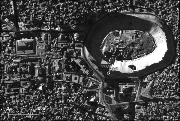
FIGURE 1. Example of a high-resolution vertical U2 photograph: Aleppo, Syria. U2 mission 8652 (Roll 1L, Frame 0040), taken November 19, 1959. Web map version at http://arcg.is/1imy0y.
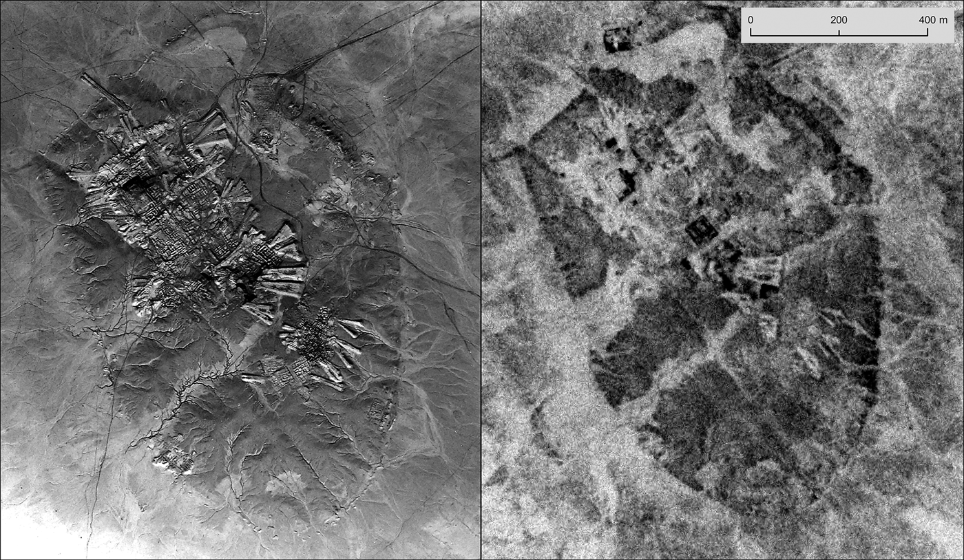
FIGURE 2. The resolution of U2 aerial photography compared to that of CORONA satellite imagery. Example from Ur (Tell al-Muqayyar), Iraq. Left: U2 mission 8648 (Roll 11L, Frame 1351, acquired October 30, 1959); Right: CORONA KH-4B (1103-1041DA026, acquired May 4, 1968).
Logistical and technical barriers have for more than a decade prevented the use of U2 photography by archaeologists. The declassification included no spatial index or finding aid for the planes’ flight paths or areas of photographic coverage. The declassified imagery is not available for purchase or download; interested researchers must photograph the original negatives at the NARA II facility in College Park, Maryland. Obtaining the imagery and georeferencing it are costly and time-intensive processes. However, as our case studies in this article demonstrate, overcoming challenges in using U2 imagery can produce important insights into archaeological and historical landscapes.
To facilitate the broader use of U2 imagery, we describe the characteristics of the cameras, film, and missions currently available in NARA and detail our methods for locating photographs and digitizing them. We also present the first spatial index of the U2 flights for which film has been declassified in the Middle East (1958–1960), developed from mission metadata and tracking film. Finally, we apply U2 imagery to our own research projects.
THE U2 PROGRAM
U2 photography was captured as part of a Cold War program that began in 1956. It was designed to provide intelligence information to the US government on the military activities of the Soviet Union, China, and their allies (for an extensive recently declassified review of the U2 program, originally written in 1992, see Pedlow and Welzenbach Reference Pedlow and Welzenbach2016). A major focus was the collection of information on the location and quantity of nuclear weapons.
The Soviet Union and Middle East–oriented U2 reconnaissance program occurred between June 1956 and May 1960. After the Gary Powers incident, President Dwight D. Eisenhower halted all U2 missions. The CIA conducted additional missions between 1960 and 1974, but improved radar and antiaircraft technology in some nations (especially China) made these missions very risky, and several planes were shot down. Military satellite imagery from the CORONA program improved in resolution and soon took over the role that aerial imagery had played.
Three detachments of U2 pilots operated in Europe and Asia up until May 1960. Detachment A in Wiesbaden, West Germany, was active from June 1956 to November 1957 and carried out 23 total missions over the Soviet Union, Eastern Europe, and the Mediterranean (Pedlow and Welzenbach Reference Pedlow and Welzenbach2016:100–102, 149). Detachment B was based at İncirlik Air Base in Adana, Turkey. It was active from September 1956 to May 1960 and carried out at least 52 missions, including 15 total Soviet overflights (Pedlow and Welzenbach Reference Pedlow and Welzenbach2016:121–136, 329). Detachment B also flew several significant missions from Lahore, Pakistan, between August 1957 and 1960 (Pedlow and Welzenbach Reference Pedlow and Welzenbach2016:143–147, 170–173). Detachment C was initially based in Alaska but shifted to Japan and the Philippines at various points in the late 1950s (Pedlow and Welzenbach Reference Pedlow and Welzenbach2016:141–143, 223–232). This third detachment carried out Soviet Union, Indonesia, Thailand, and China overflights, as far west as Tibet (Pedlow and Welzenbach Reference Pedlow and Welzenbach2016:226, 229). After May 1960, other detachments (G and H) operated out of various locations in the United States, Taiwan, the Philippines, Thailand, and India to carry out hundreds of missions over Cuba, Venezuela, British Guiana, Laos, North and South Vietnam, China, India, and Tibet (Pedlow and Welzenbach Reference Pedlow and Welzenbach2016:208–222, 232).
The Middle East–oriented U2 reconnaissance program, code-named CHESS, occurred June 1956–May 1960, with missions carried out by Detachment B from Adana. Indeed, the greatest use of U2 before 1960 turned out to be reconnaissance during and following active military conflicts in the Middle East, including the 1956 Suez Crisis and the 1958 Lebanon Crisis, with near continuous monitoring thereafter.
CAMERAS, FILM, AND MIDDLE EASTERN FLIGHTS
Researchers interested in using U2 imagery must understand the characteristics of the onboard cameras and film, which present certain challenges. In the 1950s, equipping the U2 with cameras required technological advancements, as the aerial cameras in use at the time were not high-resolution enough for use at the high altitudes that pilots were required to maintain, and better cameras were too large and heavy for the light plane. High-quality lenses with extremely long focal lengths could not be accommodated in the U2's cramped camera bay.
Cameras and Film
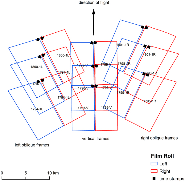
Initially, U2 planes were equipped with the A-1 and A-2 camera systems, the details of which are described in declassified documents (United States Central Intelligence Agency 1959:IV/31–36). A-model cameras were phased out after September 1958 in favor of the B-model camera (Figure 3), a system that has continued to be modified and used to the present day. B cameras captured all Middle East film currently available through NARA with a 36-inch f/10.0 aspheric lens that could resolve 100 lines per millimeter. The B-model was a high-resolution, panoramic-type camera that used a single lens to capture photos from one horizon to another in up to seven stop-and-shoot positions: a vertical frame (labeled V on the film) and three oblique frames on the left and right. These three oblique frames were taken at six increasingly oblique positions to the left and right (24.5, 49, and 73.5 degree angles, respectively labeled 1L, 2L, 3L, 1R, 2R, and 3R on the film). Each plane carried one B camera, which exposed onto two overlapping 9.5-inch film rolls that unspooled in opposite directions for weight balance (United States Central Intelligence Agency 1959:IV/35–36, 1970).
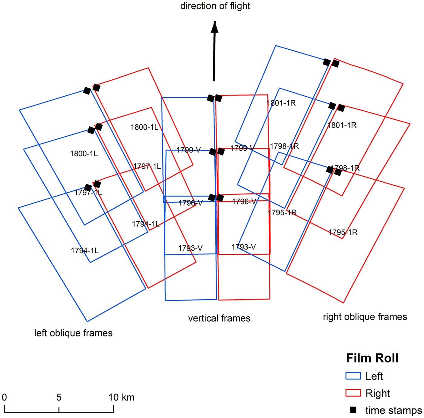
FIGURE 3. Spatial arrangement of the frames produced by the B camera configuration in Mode 2 (V, 1L, 1R) and position of each negative's time stamp in relationship to the direction of plane travel. Example from eastern Jordan, mission 1554, January 30, 1960 (Rolls 14L and 14R, Frames 1793–1801).
B cameras typically operated in one of two oblique modes: 73.5 degrees on the far right and left (Mode 1) and 24.5 degrees on the right and left (Mode 2), the second of which almost doubled the camera's operating time. The “normal” Mode 2, seen in the majority of the declassified Middle Eastern U2 film rolls, captured frames on average every 7.6 seconds in the vertical and nearest oblique positions in the sequence V, 1L, 1R. Mode 1 captured frames every 4.5 seconds from horizon to horizon in a pattern that repeated every 10 frames: V, 1R, 2L, 3L, 1L, V, 1R, 2R, 3R, 1L. Additional Modes 3 and 4 captured frames only in the right or left oblique positions. Pilots could switch modes mid-flight (United States Central Intelligence Agency 1959:IV/36–37).
Film from B camera systems was subdivided into rolls (“cans,” in the terminology of NARA) of 133 frames. Roll 1 contains frames 1 through 133, Roll 2 contains frames 134 through 266, and so forth until the final roll of the mission. The left and right halves (9 × 18 inches each) of each 18 × 18-inch frame were stored as separate rolls in separate cans; for complete coverage across the area captured along the plane's flight path, frames from both left and right rolls must be examined. In Mode 2, each roll includes approximately 16 minutes of flight time.
Regardless of the configuration of the main cameras, the U2 also always carried a Perkin-Elmer tracking camera that captured low-resolution, horizon-to-horizon photos of the terrain under the plane. The tracking camera had a 3-inch f/8.0 lens and exposed on 2.75-inch film. Each frame includes the image of a clock at the top of each frame, slightly to the right of nadir in the direction of travel. Tracking film for an entire mission was captured on a continuous roll of film and remains stored in NARA as a single can (United States Central Intelligence Agency 1959).
Frames
The layout of the negative on the film roll provides a lot of metadata for the user. Each roll has the mission number, roll number, and frame number typed on the film border. A data recording device stamped each negative with a clock in the corner in the direction of travel (upper right for the left half of the frame, upper left for the right half of the frame) along with the frame number (which occasionally becomes out of sync with the actual frame number as typed on the film border). Below the clock is an L or R, designating whether the negative contains the left or right half of the frame, and letters designating the frame position (V, 1L, 1R, etc.; United States Central Intelligence Agency 1970; Figure 3).
When the plane was flying horizontally with the B camera in the three-position Mode 2, the images in these three positions covered a swath of approximately 15 km on either side of the flight path, with a sawtooth coverage along the outer edge (Figure 3). The right and left film rolls did not overlap, resulting in a thin gap in coverage in the middle of each frame (indeed, pilots were instructed not to fly directly over important targets for this reason).
The ground resolution of B camera film varies depending on the camera position, the ground elevation above sea level, and the angle of the plane's wings in relationship to the ground. The ground resolution is highest in the vertical frame at nadir, and resolution decreases with the obliqueness of the other frames. During turns in the flight path, oblique photos in particular have lower resolution. At nadir, most vertical frames on Middle Eastern missions could resolve objects between 30 and 50 cm on the ground.
Flight Plans and Timing
The declassification process did not include easily accessible flight plans, but many missions’ itineraries can be reconstructed via a combination of declassified planning documents and the tracking film of the flights themselves (see below). Middle Eastern missions flown by Detachment B departed from İncirlik Air Base in Adana in the early morning hours and, under normal circumstances, returned to the same base after having flown across multiple countries over 8–10 hours, targeting some dozen or more specific cities or facilities. Most flights headed west along the southern Turkish coastline before banking left out over the Mediterranean, at which point missions targeting Egypt continued south toward Alexandria, while missions targeting Syria and Iraq turned back east toward the Levantine coast in the direction of Aleppo.
Known Adana-based missions covered military bases and most major cities in Egypt, Jordan, Israel, Saudi Arabia, Lebanon, Syria, Iraq, and Iran. For example, Mission 8648 (October 30, 1959) departed Adana at 5:00 GMT. It first visited the eastern Syrian cities of Aleppo, Hama, and Homs before banking left into the Syrian Desert (Figure 4). It overflew Palmyra, crossed the Euphrates at Deir ez-Zor, and headed up toward the Syrian-Turkish border town at Qamishli. At this point, the mission had already imaged at least six airfields. From Qamishli, the pilot turned east to target a sequence of Iraqi cities: Mosul, Kirkuk, Baghdad, and Basra. At the head of the Persian Gulf, the mission turned south to Riyadh, then returned back to Iraq, flying over Najaf, Karbala, and Ramadi. The plane made an extended detour north and then turned 180 degrees to cover the entire border between Iraq and Syria. The pilot returned to Adana at 13:50 GMT via the Euphrates River valley, with two detours out into the Syrian steppe to capture isolated military facilities. Mission 8648's B camera system in Mode 2 captured 5,053 frames in 39 rolls of film, plus 1,006 frames from the tracking camera. The flight traveled almost 7,000 km over the course of almost nine hours.
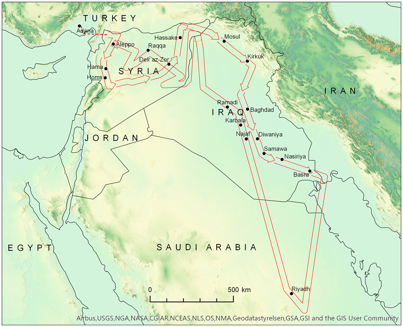
FIGURE 4. Flight path of U2 mission 8648, October 30, 1959. For an interactive web map of this figure, see http://arcg.is/b1vKb.
The only Middle Eastern country excluded from the available mission film is Israel. Flights over Israel are known to have targeted the Dimona nuclear facility, and possibly other cities and sites, but have been systematically excluded from the declassification process. This is likely due to the 1996 Kyl-Bingaman Amendment to the 1997 Defense Authorization Act, which restricts the resolution of imagery of Israel and Palestine that may be distributed by US-based companies (Zerbini and Fradley Reference Zerbini and Fradley2018).
Missions originated in the morning hours, so the early frames feature long shadows that emphasize topography and the built environment. The tracking camera appears to have always been turned on shortly after takeoff and captured continuous panoramic frames throughout the mission at an interval of 32 seconds (with one known exception). The main camera was only turned on once the plane had left Turkish airspace or when it approached the Egyptian or Levantine coast, and it was turned off once the plane returned to Turkish airspace. During the flight, the pilot turned the main camera on and off according to the needs of the mission. While on, however, the main camera captured frames continuously. When operating in the commonly used three-position Mode 2, every third frame was vertical; most features at nadir were imaged in three consecutive vertical frames during flyover.
DECLASSIFIED U2 FILM IN THE US NATIONAL ARCHIVES
Some U2 film rolls were declassified and in December 1997 were transferred to the National Archives and Records Administration (NARA), where they are available to the public. Declassifications have included both the films (rolls of negatives from the main camera and the tracking camera) and also various documents pertaining to the planning, completion, and analysis of various missions and their photographs. Geographic finding aids for the most part remain classified. One exception is mission 1480, for which there are declassified maps that include the flight path, frame footprints, and frame numbers, as well as indications of where the pilot switched the main camera between Modes 1 and 2 (United States Central Intelligence Agency 1960a). Indexes held in the cartographic reading room list film cans by mission number and date but do not include any other information. On the other hand, declassified documents related to U2 missions exist in the National Archives via the CIA Records Search Tool (CREST), which indexes historically valuable intelligence records 25 years or older.Footnote 1 These records can include planned flight paths and target coordinates, reports on mission weather conditions, and even analyses of targets, but they are very uneven in coverage. The connection between the documentary record in CREST and the film held by NARA must be established by the researcher. We present here a spatial index to U2 film held by NARA that draws on the relevant records in CREST and on geographic information obtained from low-resolution tracking camera film.
U2 film must be viewed in the cartographic reading room at the National Archives and cannot be scanned at this time. The film rolls themselves are stored on their original spools in the NARA cold storage facility in Lenexa, Kansas, nicknamed the “Ice Cube.” Researchers may access film rolls by ordering them for delivery to the NARA Aerial Film Section in College Park, Maryland. The Aerial Film Section has several light tables available for unspooling and viewing film negatives.
Middle Eastern U2 Missions in NARA Collections
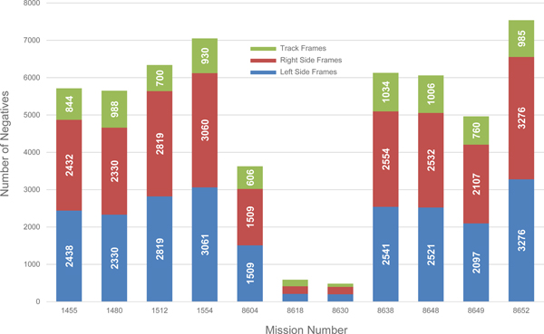
The index held in NARA lists film rolls from 11 Middle Eastern missions, ranging in date from August 12, 1958, to January 29, 1960 (Figure 5; Table 1). These 11 missions represent a fraction of the total number of missions flown, but they do constitute an estimated 46,000 frames from the main cameras and an additional 8,100 frames from the tracking cameras.
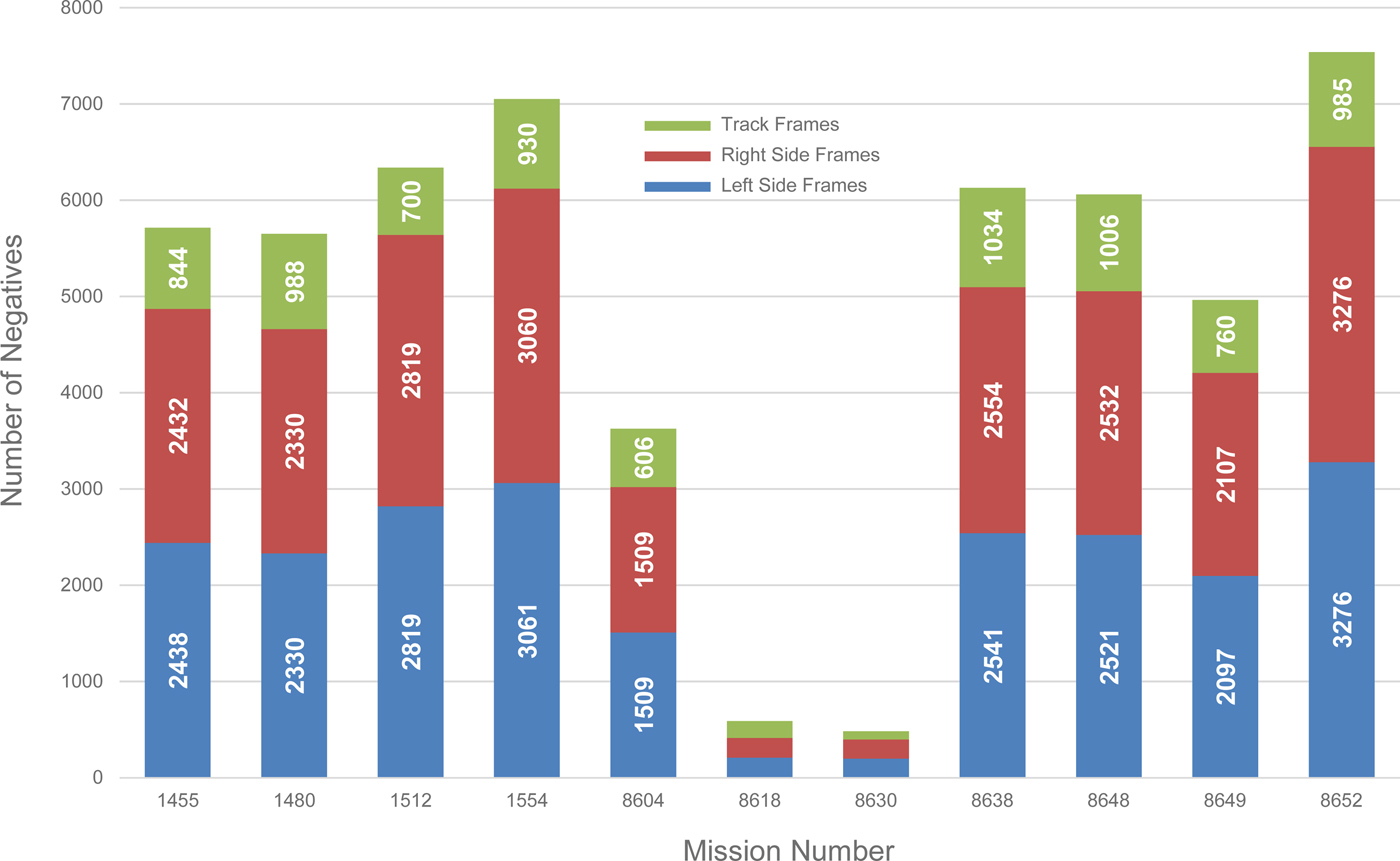
FIGURE 5. Declassified U2 missions indexed in the NARA cartographic reading room. Bars represent the number of half frames (negatives) available for each mission.
TABLE 1. U2 Missions with Film in the US National Archives and Their Characteristics.
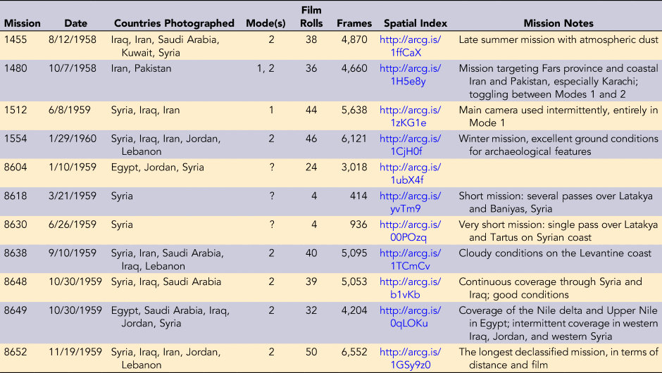
Note: Mode 1 is the seven-position configuration that photographed from horizon to horizon; Mode 2 acquired three positions (vertical and near-oblique). Film Rolls and Frames count both left and right negative sides separately and do not include tracking film rolls and frames. For geospatial data, see Ur and Hammer (Reference Ur and Hammer2018).
An index to the available cans of U2 film is available in the NARA cartographic reading room (marked “RG-263”). This index lists the missions and flight dates for each can and the NARA serial numbers required to recall the can from cold storage (designated as the ON number and BARCODE). Very little other information is available, however. The index does not indicate the roll number of the can's film (i.e., it gives no indication about where the film falls in the sequence of rolls acquired during the mission). Nor does it indicate whether the cans contain the left or right side of the frames, or whether the film derives from the tracking camera or the main camera. No geographic information about the missions or the positions of film acquisition are provided.
The final column of the NARA U2 index is the CAN number, which is the key to connecting the NARA holdings to useful spatial information. This can number can be related to a partially declassified document in CREST called the “Film Control List” (United States Central Intelligence Agency 1972). This index originally listed all rolls of film for aircraft missions between 1956 and 1965, ordered by CNTROL number, mission, and roll. It also includes the mission date and the roll's frame numbers. This CNTROL number is identical to the CAN number in the NARA index, and by joining them, it is possible to determine the roll number of NARA's holdings.
At this stage, it remains necessary to reconstruct the flight paths of these available U2 missions, which can be done in several ways. Coordinates for U2 flights are available from declassified planning cables and post-mission reports, which occasionally contain details of the mission and its photographic targets. In the best case, reports describe planned or executed missions by an ordered series of coordinate pairs in degrees and minutes (e.g., “3659N 3517E,” the location of Detachment B's airfield in Adana). Many such reports are available through CREST, and they include missions for which film has not been declassified. These flight itineraries are only roughly accurate (see, for example, a declassified cable describing the planned route of Mission 1554 [United States Central Intelligence Agency 1960b]).
For missions available at NARA for which no such documents are available via CREST and for which CREST documents only provide very general coordinates, the low-resolution tracking film frames (Figure 6) can serve as an accurate source of spatial information for the flight paths. Time-stamped tracking camera frames can be geolocated with reference to various virtual globe web applications; for this project, we used Google Earth and ESRI ArcGlobe. We operated on the assumption that the tracking clock was stamped roughly at the location of nadir (now known not to be accurate, see below). This laborious process was repeated for enough tracking frames to reconstruct the plane's path. For example, our reconstruction of Mission 8638 (October 10, 1959) involved the geolocation of 613 of the mission's 1,034 tracking frames.
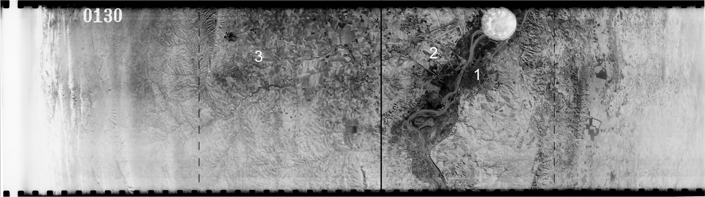
FIGURE 6. Annotated example of a tracking camera frame (U2 mission 1554, January 30, 1960, Tracking Frame 0130). The upper edge is the direction of flight, in this example southeast over the modern city of Mosul (1) and the ancient Assyrian city of Nineveh (2) on the Tigris River in northern Iraq. To the left was the ancient Assyrian city of Khorsabad (3). At the far left horizon are the Zagros Mountains. The dark line is the flight path (nadir); the dashed lines represent the approximate boundaries of photographic coverage in three-position Mode 2. Note the off-nadir position of the clock stamp.
The tracking film clock stamp provides a rough but not precise guide to the plane's location. For example, Mission 8638 flew directly over Tell Brak, an early urban site in northeastern Syria (Figure 7). The georeferencing of its left and right vertical negatives demonstrates that the clock was stamped approximately 5.4 km right of nadir. In the case of Mission 1455 (August 12, 1958), the tracking frame camera was 7.2 km right of nadir, also demonstrated by the vertical camera.
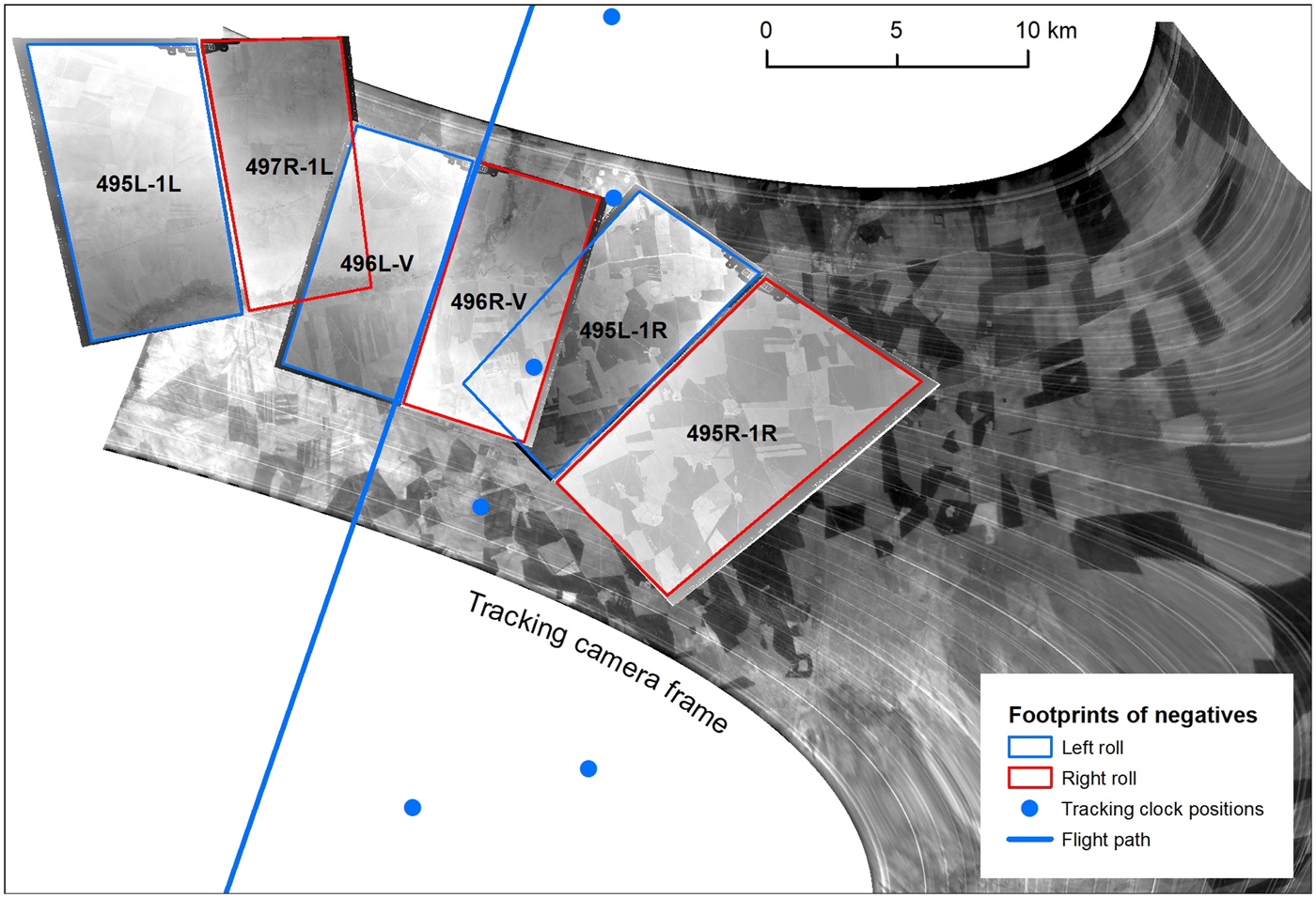
FIGURE 7. Inconsistency between the tracking frame and vertical frame nadir. Example from Tell Brak, northeastern Syria, U2 mission 8638 (October 10, 1959, Rolls 4L and 4R, Frames 0495–0497). Web map version at https://arcg.is/0uTmeH.
The geographic index presented here (Figure 8) is a roughly accurate but still incomplete guide to photographic coverage. Because the main camera was only turned on once the plane left Turkish airspace or approached its first target, the start of the mission near Adana (i.e., the start of the tracking film coverage) is not coincident with the start of frame acquisition by the main camera system. For example, Mission 1480 (October 7, 1958) was already 1:42 into its mission before its main camera was turned on; it had already traveled across southeastern Turkey and the length of Iraq before capturing its first frames near Ahwaz in southwestern Iran. Likewise, Mission 1455 (August 12, 1958) took off and circled over eastern Turkey for 1:08 before initiating main camera photography at the Syrian border.
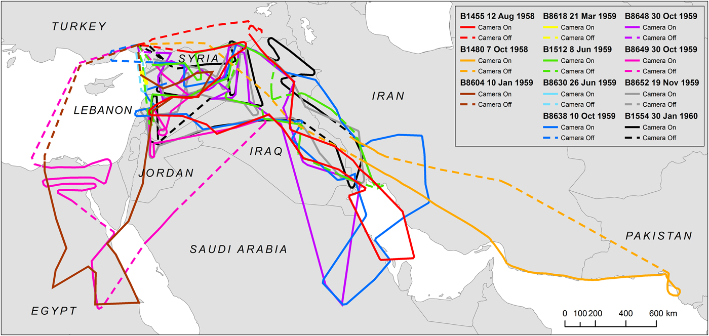
FIGURE 8. Flight paths for the 11 declassified Middle East U2 missions held by NARA. Flight paths have been reconstructed using low-resolution tracking film, and photographic coverage has been reconstructed by examining the first and last cans of film for missions and mission metadata in declassified documents. Web map version at https://arcg.is/0yz1rK.
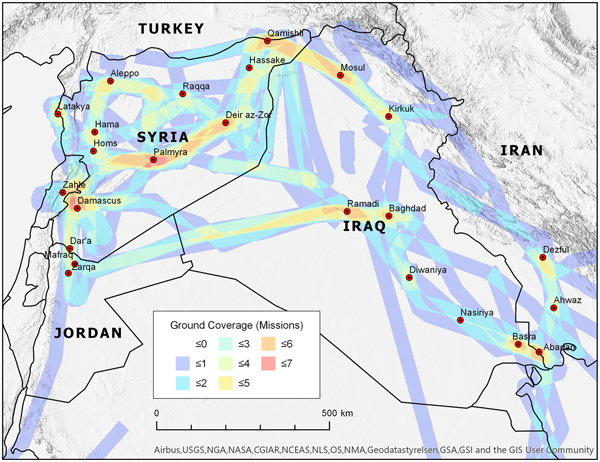
The spatial index we have created of Middle East U2 missions available at NARA shows several patterns (Figure 9). By far the densest U2 coverage among the available missions occurred over Syria, with riverine parts of Iraq taking second place. Most of the available missions flew a similar path: east from İncirlik across southern Turkey or northern Syria/Iraq, then south along the Tigris River or Zagros Mountains through Iraq/Iran, then west across the eastern panhandle of Jordan or southern Syria, and finally north across western Syria, back to İncirlik.
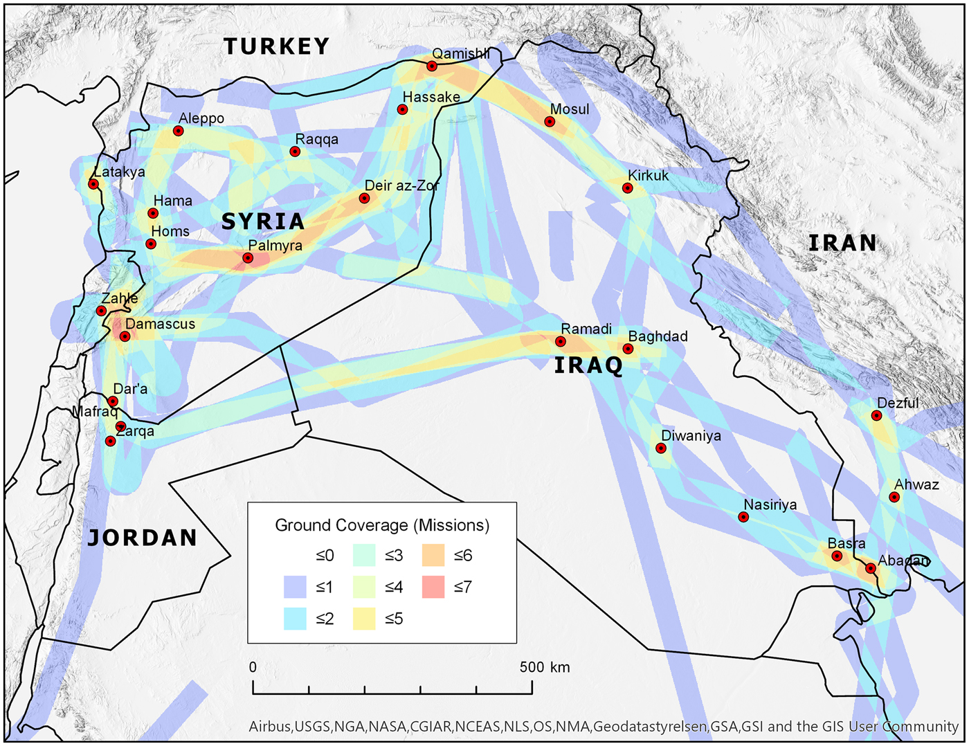
FIGURE 9. The intensity of U2 photographic coverage for declassified U2 missions in the central Middle East. Web map version at https://arcg.is/1bn1Ge.
Ordering, Examining, and Acquiring Imagery
NARA-held film must be viewed in the cartographic reading room in the NARA II facility in College Park, Maryland. Orders must be placed in person, at which point they are requested from the cold storage facility; arrival at NARA takes 1–2 days. Researchers are allowed 10 rolls of film at one time.
In the reading room, films must be unspooled on light tables. For proper orientation, U2 film from the main camera is loaded underhand from the right spool. Each negative includes a time stamp, positioned in the “inner” corner (toward the center of the plane) in the direction of the plane's flight path (Figure 3). Knowing the position of the time stamp can help to orient the researcher spatially when the film is unspooled over the light table. For orientation purposes, it can be useful to first browse the entire roll of film and look for easily recognizable landmarks such as cities/towns, bridges or road intersections, and distinctive bends in rivers’ courses.
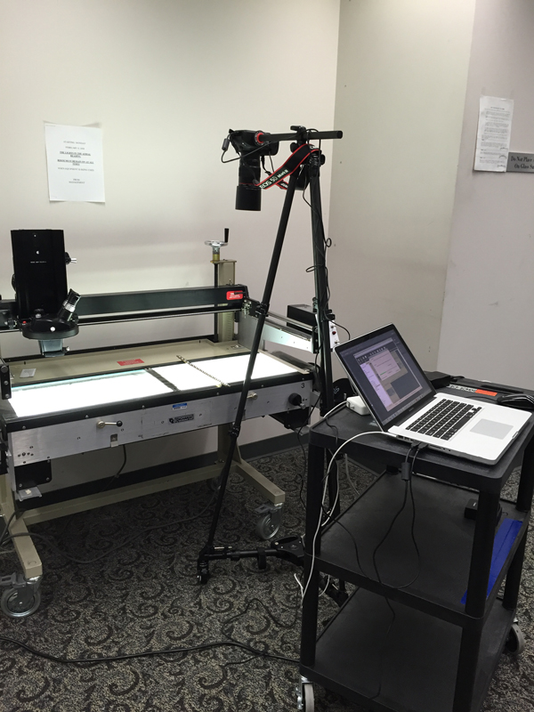
NARA does not have scanners capable of accommodating U2 film spools at this time, and there are strict limitations on the handling of film in NARA collections; researchers must therefore photograph the negatives. We describe here our protocols for capturing useable digital images of U2 films, although we recognize that ours is only one of many possible methods. We employed a Canon 5D Mark III camera with a 100 mm macro lens, set on a lateral tripod that positioned the camera horizontally over the light table (Figure 10). The camera's settings and shutter were manipulated via Canon's remote shooting software (EOS Utility) on a PC laptop. This is essential to avoid moving the camera even slightly while focusing and capturing the photo but also offers other important advantages, like the ability to preview before taking a photo and the ability to easily implement sequential file-naming schemes. Images were captured in 16-bit RAW format.

FIGURE 10. An example of the authors’ equipment set up in the NARA Aerial Film Section, with light table, camera and 100 mm macro lens on lateral tripod, and laptop running remote shooting software. Photograph by Emily Hammer.
Depending on the height of the lens above the light table, the full extent of each negative on the 9.5-inch U2 film strips could be captured in 3–6 partial images with this camera setup. It is possible to capture the entire negative with a 50 mm macro lens, but at the cost of some film resolution. We use Adobe Photoshop to invert the images and covert them to grayscale TIF format and then to reconstruct each negative (Photomerge). TIFs of full negatives were georeferenced in ArcGIS using ESRI's imagery base map data and sometimes with reference to georeferenced CORONA satellite imagery, which was acquired a decade after the U2 missions. Mosaicking in Adobe Photoshop introduces some geometric distortions, but in our experience, the small amount of spatial error is offset by the considerable time savings of georeferencing by full U2 negative rather than by the individual image (3–6 per U2 frame). Following effective photography and georeferencing, the spatial resolution of the reconstructed U2 negatives varies but can be as high as 0.4 m/pixel in vertical frames.
Open Access Spatial Data and Web Maps
To facilitate searching for and ordering U2 film at NARA, we have created two online resources. The first is a complete set of geospatial data hosted on Harvard's Dataverse, an open access data repository (Ur and Hammer Reference Ur and Hammer2018). These data include shapefiles (.shp) for flight path, photographic area of coverage, tracking frame clock positions and timing, and the footprints for individual negative frames that we have georeferenced for all 11 of the NARA-held missions. Nonspatial data include a guide to the spatial index and notes for each mission (all in PDF format). Finally, we include a tabular list of every individual film roll available via NARA with the ON, BARCODE, and CAN numbers required to recall the film from the cold storage facility. These ordering numbers are also included in the attributes of the flight path and photographic coverage spatial datasets. These datasets can be downloaded, viewed, and queried in any GIS application.
We have also made these data available via a series of dynamic web maps on ESRI's ArcGIS Online platform. These maps can be accessed via a web browser (Figure 11; see map URLs in Table 1) or via ESRI's free ArcGIS Explorer app and contain layers for flight path, photographic coverage, and (when available) the positions of the tracking camera clocks and the ground footprints of individual frames. Users can zoom in and toggle between various map, topographic, and imagery base maps to determine whether a given mission covers their area of interest. Clicking on any feature displays its attributes; for the flight path and photo coverage layers, these attributes include the ON, BARCODE, and CAN numbers needed to order the film at NARA. Wherever possible, we have segmented the flight path and photo coverage features to correspond to the individual film rolls (coverage shown in red); in other places, we can approximate the coverage but cannot specify the exact film roll number (shown in gray). These spatial data are intended to be dynamic and will be updated; users are encouraged to send the authors their corrections and additions.
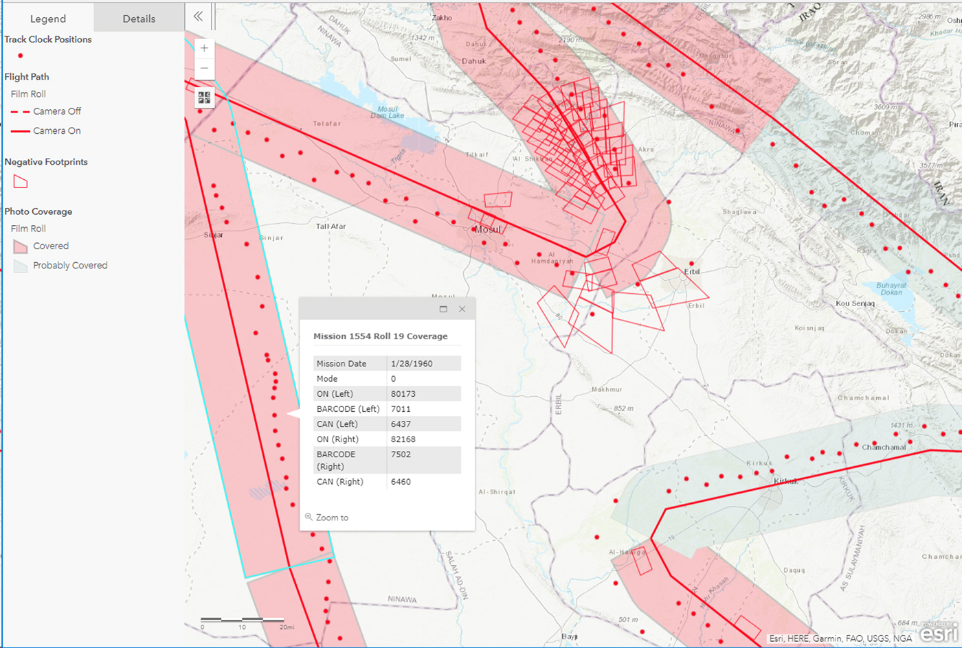
FIGURE 11. An example of the open access digital maps we have made available via ArcGIS online. In this case, the map shows part of mission 1554, January 30, 1960, as it covered parts of northern Iraq near Mosul and Erbil. The attribute table of the photographic coverage dataset contains the information necessary for ordering particular film rolls from NARA.
CASE STUDIES IN ARCHAEOLOGICAL LANDSCAPES FROM THE MIDDLE EAST
We present three case studies illustrating the usefulness of U2 imagery for Middle Eastern archaeology, drawn from our own research. We have found that the most useful U2 photographs for archaeological and historical work in the lowland plains of the Middle East come from missions flown during the late fall and winter months, when moisture differences in the ground make anthropogenic soils more visible; photographs from summer missions are frequently unclear because of atmospheric dust and the overall desiccation of the ground. The high resolution and raking light characteristic of U2 photographs makes standing architecture visible in nearly all missions.
Prehistoric Desert Kites in Eastern Jordan
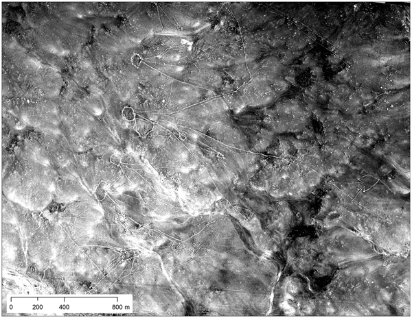
When browsing through U2 imagery from the available Middle East missions, some of the most striking photos cover the black basalt desert (harra) of the eastern panhandle of Jordan. These photos stand out not only because of the surprising lightness of the negatives (due to the visual darkness of the major surface geological formations, broken by sinuous bands of lighter loess deposits) but also due to the visibility of hundreds of huge stone-walled constructions called “desert kites” as well as other stone-walled features such as villages, corrals, and circular structures that resemble spoked wheels, all in a sparsely inhabited landscape (Figure 12). Desert kites—which consist of an irregular polygon enclosure with long “tails”—are widely believed to be mass-kill hunting traps for gazelle and other large ungulates, constructed by Neolithic and/or Chalcolithic and Early Bronze Age communities inhabiting the harra (for debates concerning the dating of kites in Jordan, see Bar-Oz et al. Reference Bar-Oz, Zeder and Hole2011; Betts Reference Betts2014; Helms and Betts Reference Helms and Betts1987; Zeder and Bar-Oz Reference Zeder and Bar-Oz2014; Zeder et al. Reference Zeder, Bar-Oz, Rufolo and Hole2013). With the increasing availability of high-resolution modern satellite imagery, archaeologists have begun to systematically map kites across the region (e.g., Crassard et al. Reference Crassard, Barge, Bichot, Brochier, Chahoud, Chambrade, Chataigner, Madi, Régagnon, Seba and Vila2015; Kempe and Al-Malabeh Reference Kempe and Al-Malabeh2013; Kennedy Reference Kennedy2011). An aerial perspective is essential for the study of kites because many rock features in the harra are too large and/or faint to be seen from the ground.
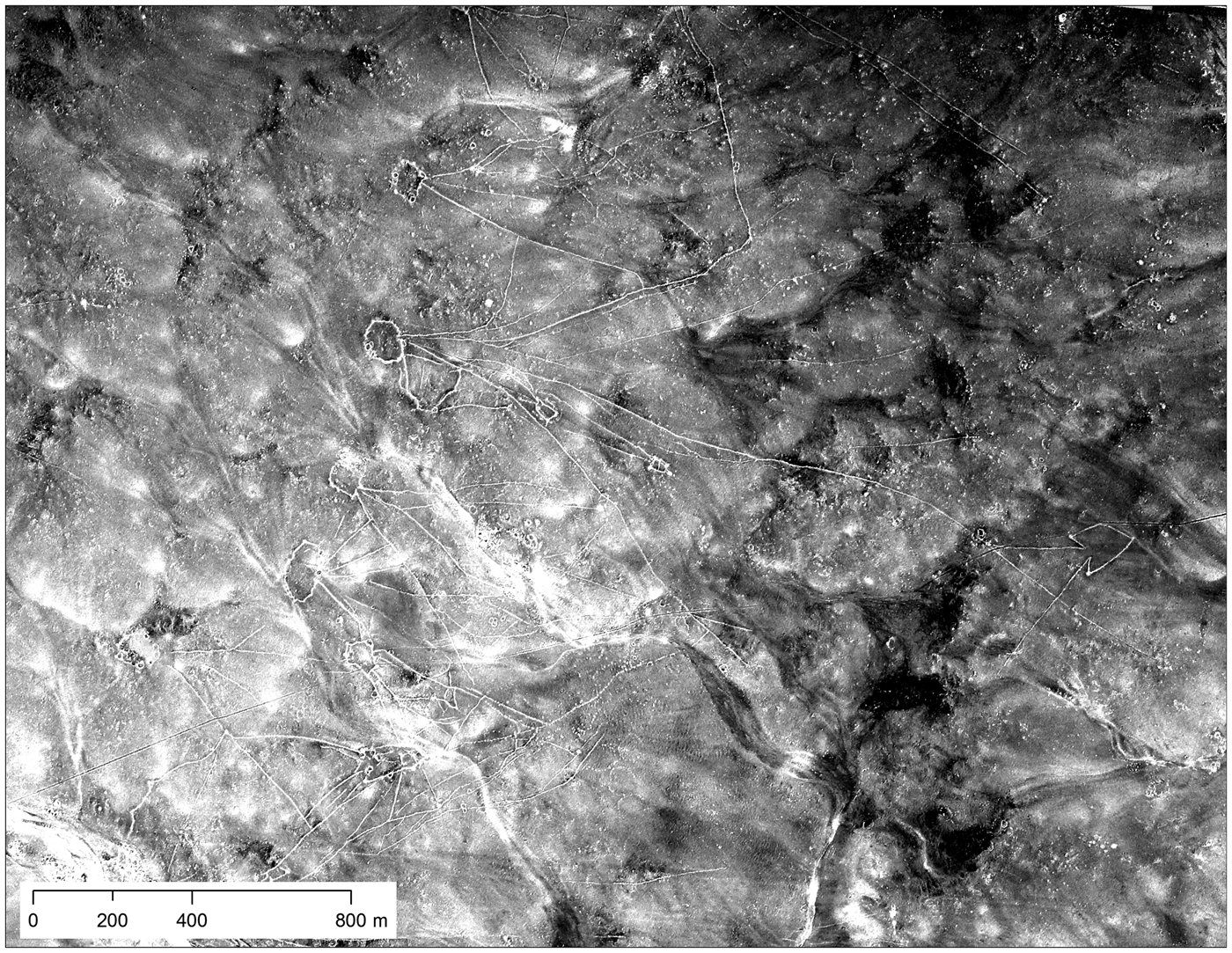
FIGURE 12. Chains of desert kites as visible in U2 imagery from mission 1554, January 30, 1960 (Roll 14L, Frame 1783). Web map version at https://arcg.is/0jreeP.
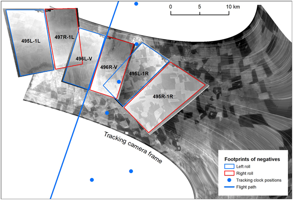
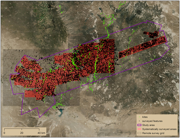
One of the authors has studied the distribution of desert kites and tens of thousands of other stone features visible in U2 imagery from mission 1554, January 29, 1960 (Hammer and Lauricella Reference Hammer and Lauricella2017). This project involved georeferencing 186 negatives covering over 6,100 km2 and systematically inspecting the imagery in order to map visible archaeological features. The overlapping arrangement of photos captured by the vertical and oblique cameras on the left and right sides of the plane is visible in project maps (Figure 13). The splayed arrangement of the negatives at the western end of the study area is due to a northward turn in the plane's path, as the pilot headed back to İncirlik.
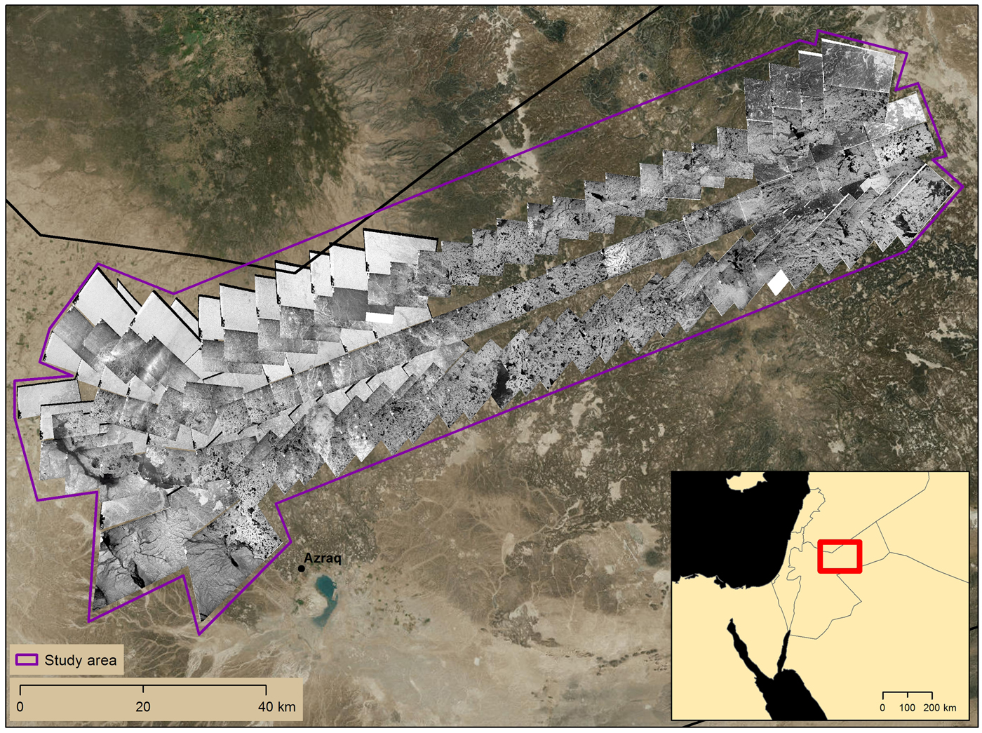
FIGURE 13. Spatial coverage of U2 mission 1554 (Rolls 14L and 14R, Frames 1730–1821) over the harra of eastern Jordan and boundaries of the case study area.
U2 imagery of the harra frequently showed desert kites and other features in a much better preserved state than in modern DigitalGlobe imagery. We were able to map many features that have been destroyed since 1960 and are no longer visible in modern imagery (Figure 14). This is particularly true for villages, corrals, and wheel structures, which are smaller than desert kites and more vulnerable to total erasure by modern agriculture and development. CORONA imagery dating to the late 1960s is available for this area but is not uniformly useful for mapping desert kites; only the highest resolution parts of the images, near nadir, are detailed enough to resolve the thin walls of kites and smaller stone archaeological features. U2 photographs allowed us to present a more complete picture of the archaeological landscape than would have otherwise been possible, and allowed us to make more informed arguments about the relationship of certain types of archaeological features to one another and to environmental variables. This case study shows how U2 imagery can be especially useful for the archaeological and historical study of places where CORONA imagery is either not of particularly high resolution or is not high-resolution enough to resolve the archaeological features of interest.
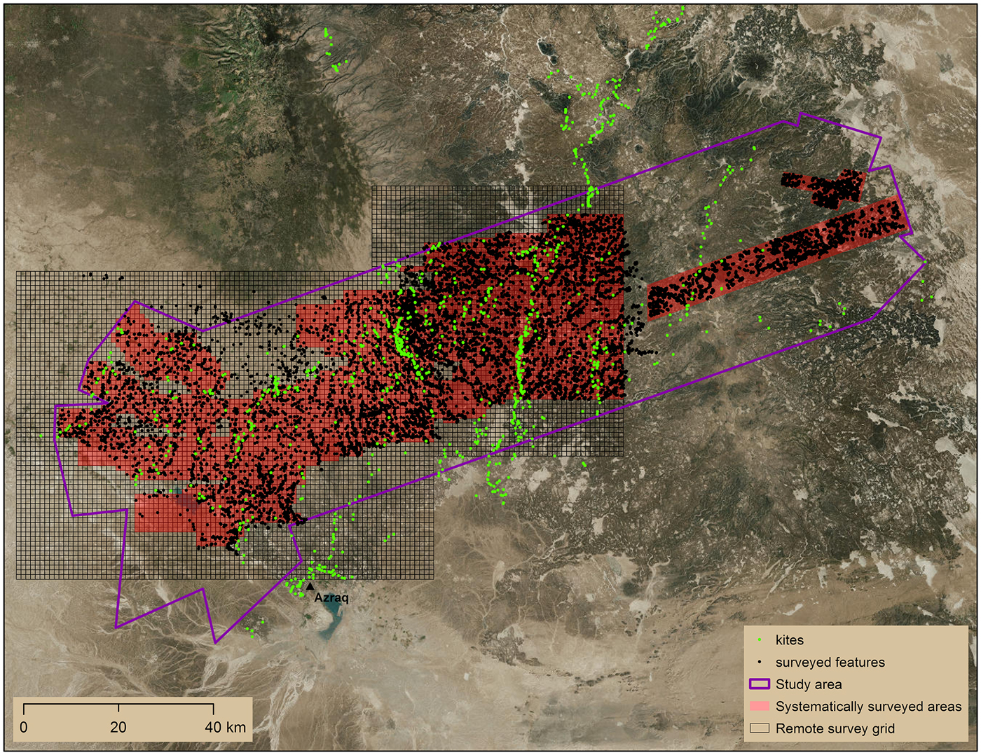
FIGURE 14. Locations of features and kites systematically mapped using U2 imagery over eastern Jordan.
Water Management in Northern Iraq in the First Millennium BC
A combination of U2 and other imagery sources has been critical in reconstructing the canal systems in the imperial core of the Neo-Assyrian Empire (ca. 911–612 BC) in northern Iraq (Ur and Reade Reference Ur and Reade2015). The city of Nimrud, located along the Tigris River, served as the empire's capital for generations, and was one of the largest cities on earth for its time. The incised, shifting nature of the Tigris and the height of the town on the terrace above the floodplain meant that Tigris water had limited irrigation use in the absence of water-lifting technology; canals were necessary to supply the city with water for consumption and for irrigation of royal parks and gardens. In this semiarid region, irrigation systems fed orchards and fields in Nimrud's sustaining area. Like desert kites, an aerial perspective has been central to the study of the Neo-Assyrian Empire's irrigation systems because the remains of their large canals are frequently invisible on the ground, and many of them remain difficult or impossible to access due to the ongoing geopolitical situation in the Republic of Iraq.
Imagery from mission 8648 (October 30, 1959) and mission 1554 (January 29, 1960) was combined with historic CORONA and HEXAGON and modern DigitalGlobe satellite imagery to map traces of canals on either side of the Upper Zab River, a major tributary of the Tigris River that cut through the core of the Assyrian Empire in the early first millennium BC (Figure 15).
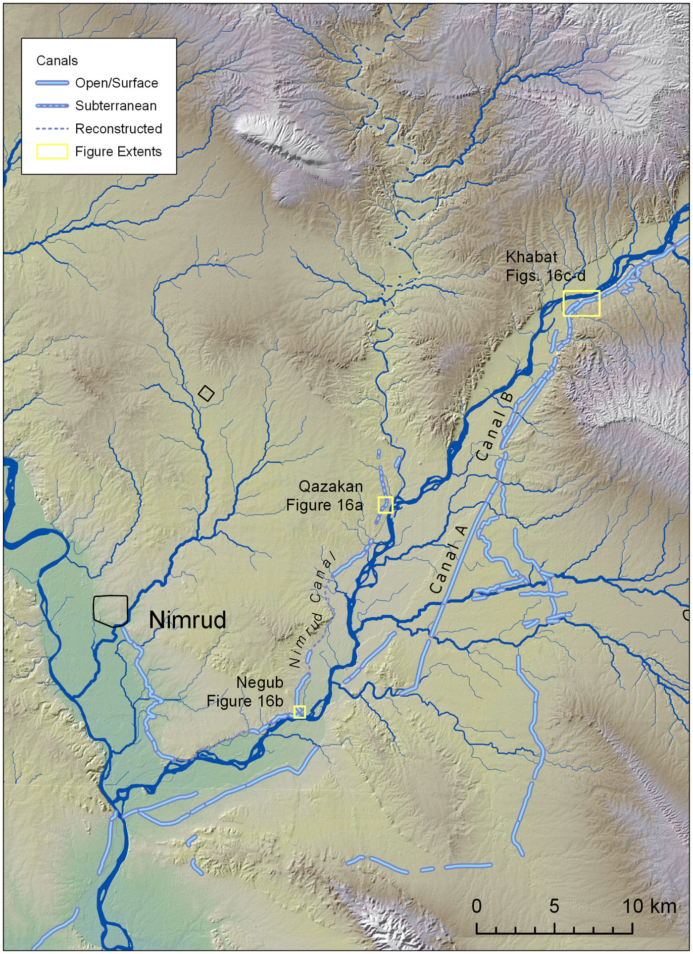
FIGURE 15. Canal features in the hinterland of the Assyria imperial capital at Nimrud. Web map version at https://arcg.is/OaDD9.
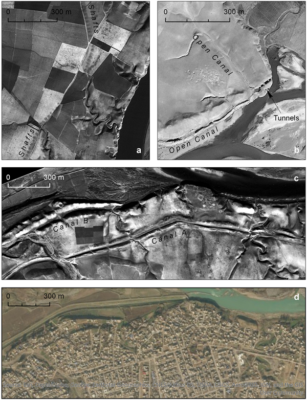
The earliest known canal in this region led from the Khazir River (a tributary of the Upper Zab, which is itself a tributary of the Tigris) to Nimrud, which was the imperial capital at the time. Archaeologists documented portions of this canal on the ground throughout the late nineteenth and early–mid-twentieth centuries, but the use of a combination of imagery sources allowed for the first systematic description of how water reached the ancient city, likely irrigating various areas on the Upper Zab and Tigris terraces and floodplains along the way. Each set of imagery had its own advantages and disadvantages, and the whole canal was not visible in any one set. The reconstruction resulting from combined imagery sources suggests that the canal may have served as a low friction way to transport agricultural products downstream to Nimrud and that the canal could have been part of a larger river transport network capable of bringing agricultural products from even further away, from rain-fed agricultural plains over 60 km to the north of Nimrud. The availability of U2 aerial photograph has dramatically enhanced our knowledge of this feature and its operation. The high resolution of U2 film revealed the existence of a likely subterranean component of this early canal, revealed by the vertical shafts that were used to construct and maintain it (Figure 16a). These shafts were invisible or ambiguous in later CORONA and HEXAGON satellite photography. The high-resolution shadows of the early morning flights also led to new discoveries; for example, when the canal passed through the excavated rock outcrop at Negub (Figure 16b). The open canal was chiseled into the side of the river terrace but also cut through it via two tunnels. An open channel led in from the north, and a looted archaeological site sat above this complex feature to its west. Neither of the latter two elements had been previous recognized.

FIGURE 16. Ancient canals in northern Iraq: (a) U2 photograph of the subterranean canal above the Assyrian capital city of Nimrud (Mission 1554 Frame 398, January 29, 1960); (b) U2 photograph of Assyrian canals, tunnels, and sites at Negub (Mission 8648 Frame 853, October 30, 1959); (c) canals and site on the right bank of the Upper Zab River (Mission 1554 Frame 402, January 20, 1960). Web map version at https://arcg.is/uDb94; (d) DigitalGlobe image showing the growth of the modern town of Khabat over the features in 16c (June 2, 2016).
On the opposite (right) bank of the Upper Zab, several canals were excavated, both longer than the Nimrud canal and both probably later (Ur et al. Reference Ur, de Jong, Giraud, Osborne and MacGinnis2013:106–107). The remains of Canal A are highly linear and are found relatively high on the river terrace; it is likely to date to the Sasanian era (early first millennium AD). Canal B is more constrained by its terrain, lower on the terrace, and often taken away entirely by lateral movements of the Upper Zab River (Figure 16c). It is likely to date to the time of the Assyrian Empire. Much of these canals were still visible by the time of CORONA and HEXAGON acquisition. However, the resolution of the U2 photographs allowed their morphological differences to be documented accurately and revealed features not visible in other sources (see, for example, the small fort in Figure 16c). The early date of the photographs preserves these and other features that have long vanished under intensive agriculture and urban development (compare Figures 16c and 16d).
This case study shows how U2 imagery can contribute important archaeological and historical insight even in places where CORONA imagery shows many ancient features. Seasonality of the U2 and other historical imagery used in the study was important, as the imagery only revealed buried canal and well features at times where there was adequate moisture in the soil.
Spatial Ethnohistory of Twentieth-Century Marsh Communities in Southern Iraq
U2 photography can be used to study “recent” archaeological phenomena such as the landscapes of the Marsh Arabs of southern Iraq. The Marsh Arabs’ wetland home was negatively impacted by the expansion of irrigation land throughout the Tigris and Euphrates watersheds in the latter half of the twentieth century and especially throughout the 1980s onward by the construction of massive hydroelectric dams in Turkey and Syria, all of which have severely reduced the flow of freshwater needed to maintain the southern Iraqi marshes. These long-term processes were greatly accelerated by Ba'athist state actions in the 1990s, which deliberately targeted the Marsh Arabs by draining the marshes, forcing communities to abandon their villages and their way of life (Pearce Reference Pearce and Pearce2006).
Although several mid-twentieth-century ethnographies detail the Marsh Arabs’ social, political, and economic organization (Salīm Reference Salīm1962; Thesiger Reference Thesiger1964), they do not record information about the spatial organization of the Marsh Arab landscape. With U2 imagery, we are able to conduct a spatial ethnohistory of Marsh Arab communities in the late 1950s and early 1960s, mapping and recording marsh village layout, size, and position within the environment.
Such a study obviously has value for our understanding of recent Iraqi history but additionally can more indirectly serve as an important potential analogy for ancient marsh occupation at the time of the earliest Mesopotamian cities. Recent research has shown that the Persian Gulf and its surrounding marshlands may have extended considerably further north in antiquity than they do today (Pournelle Reference Pournelle and Crawford2013). Thus, the earliest Mesopotamian cities and states, which developed from the fifth to the third millennia BC, may have grown within and at the edge of wetland environments.
In the roughly 280 km2 of the Central Marshes covered by U2 mission 1554 in January 1960, there are 43 marsh villages, including inhabited and abandoned villages (Figure 17). Twenty of these villages (16 inhabited and 4 abandoned) have clearly visible structures. The smallest village has 4 and the largest 73, with a mean of 28. These village sizes are between 7.2 and 0.3 ha, with a mean of 2.3 ha. Abandoned villages with visible structures are likely to have been more recently abandoned than other abandoned villages that are identified only by means of their elevation above the water and their position within a network of radiating paths through the marsh. Two of the four recently abandoned villages and three of the more distantly abandoned ones are directly beside currently inhabited villages that are larger than the abandoned ones, indicating that marsh villagers tended to produce “horizontal stratigraphy” rather than resettling on top of existing villages (Figure 18). Villages tend to preferentially be located on “fingers” of higher ground that extend into the marsh from its edges, providing easy routes in and out of the marsh. This is especially true of villages located on the eastern edge of the marsh, nearest to the river.
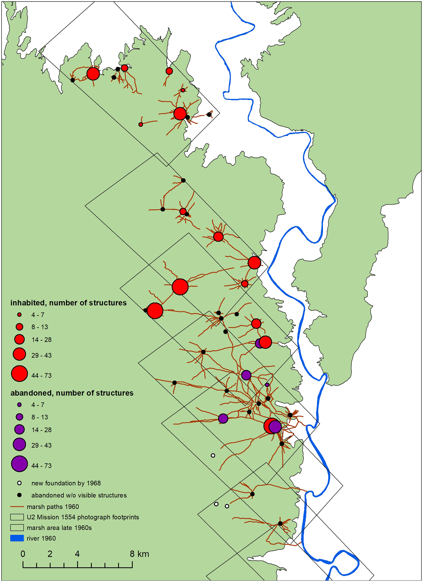
FIGURE 17. The distribution and size of Marsh Arab villages in the Central Marshes of southern Iraq, U2 mission 1554, January 1960 (Roll 10R, Frames 1272, 1275, 1278, 1281, 1284, 1287, 1291, 1293).
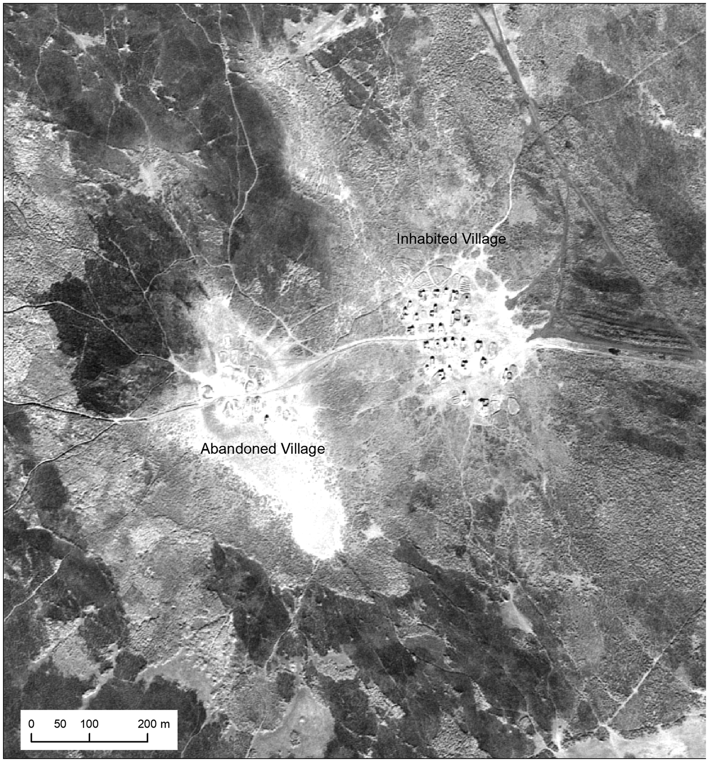
FIGURE 18. An inhabited and adjacent abandoned Marsh Arab village in the Central Marshes of southern Iraq, U2 mission 1554, January 1960 (Roll 10R, Frame 1284). Web map version at https://arcg.is/150muS.
The high-resolution U2 imagery of the marshes complements and extends historical analyses of the Iraqi marsh villages with later, lower-resolution KH4A CORONA imagery from 1969. CORONA imagery shows the spatial arrangement of villages in the marsh landscape and the rough extents of marsh settlements (Al-Dafar Reference Al-Dafar2015), but it does not always resolve individual structures as the U2 imagery reliably does. Where the CORONA does resolve structures in inhabited and recently abandoned villages, it is impossible to tell the difference between abandoned and inhabited structures as one can in the U2. Thus, the U2 imagery is necessary for better recognition and interpretation of structures. It additionally provides data on marsh settlements almost a decade before CORONA, in the future enabling studies of marsh village foundation, inhabitation, abandonment, and reinhabitation.
This case study provides an example of how U2 and CORONA are important in complementary ways for putting together a demographic and spatial dataset useful for both modern historians and archaeologists.
CONCLUSION
As our case studies demonstrate, declassified imagery captured by U2 spy planes has enormous potential to aid historical and archaeological studies of settlement sites and landscapes in Eurasia. The fields of geography, environmental science, and urban studies can also benefit from the detail and age of the U2 archive for historical and diachronic studies. U2 images are up to a decade earlier and higher resolution than the declassified KH4A and KH4B CORONA images that have transformed the field of Eurasian landscape archaeology over the last two decades. Unlike CORONA, U2 coverage is limited to particular flight paths that are not well mapped in declassified documents, but U2 imagery does provide broad coverage of significant areas of the region. U2 photos can be useful for targeted projects where very high-resolution imagery is needed as well as for projects looking at change over decadal time.
In an effort to remove barriers preventing the widespread use of U2 photography by archaeologists, we have developed an online, open access spatial index for the Middle East missions for which NARA holds declassified film rolls (Ur and Hammer Reference Ur and Hammer2018). We have also presented our methodology for reconstructing U2 flight paths using a combination of declassified CIA documents and U2 tracking film as well as our methodologies for obtaining photographs of film negatives and for reconstructing and georeferencing frames in a GIS. Our Middle East mission spatial index makes it easy for researchers to identify film roll(s) of interest. The methodologies we have shared could be applied by others to create similar spatial indices for Eastern Europe, the Soviet Union, China, and other regions with significant sets of declassified film. Our three archaeological and ethnographic case studies only cover a small range of the possible uses of U2 images, and our work thus far has only explored a subset of available imagery. It is our hope that the details presented in this article will allow a broader base of researchers to exploit the massive potential of the U2 archive.
Acknowledgments
The knowledgeable assistance of Lin Xu was central to our efforts to piece together details about U2 photography and our ongoing efforts to develop a spatial index of available missions. The National Archives’ Aerial Film Section in Greenbelt, Maryland, enabled access to U2 imagery used in this article. We thank the staff of that facility, especially Gerald Luchansky, for their assistance. Student GIS assistants in the Center for Ancient Middle Eastern Landscapes (CAMEL) at the University of Chicago's Oriental Institute assisted in the reconstruction of some U2 flight paths via tracking film. For the Jordan desert kites case study, student GIS assistants in CAMEL also georeferenced U2 frames and helped with identification of kites and other features in the imagery. The efforts of Anthony Lauricella and Émilie Sarrazin deserve particular mention. The abstract was translated into Spanish by Carlos Pereira Di Salvo.
Data Availability Statement
As detailed in the article text, open access digital maps of U2 flight plans, photographic coverage, tracking frame nadir positions, and select high-resolution frame footprints are available online via ArcGIS online. These data are connected to ON and BARCODE numbers needed to order film rolls from the National Archives. The digital maps will be continually updated as more data are acquired. Shapefile versions of these data, along with PDFs containing notes about each declassified U2 mission, are downloadable via Harvard Dataverse: https://doi.org/10.7910/DVN/VD74QX.


 Open access