


INTRODUCTION
Teotihuacan was one of the largest and most influential cities in ancient Mesoamerica (Smith Reference Smith, Hirth, Carballo and Arroyo2019). In spite of many decades of archaeological excavation and analysis at this site, the basic nature of the city's population and social groupings remain under debate. A major reason is that most investigations have tended to rely upon either an intensive reading of local-scale evidence, such as one or two excavated structures (Cabrera Castro and Gómez Chávez Reference Cabrera Castro, Chávez, Mastache, Cobean, Cook and Hirth2008; Daneels et al. Reference Daneels, Domenici, Jilote, Grazioso, Layet, Seguar, Nobile, Bautista and Manso1996; Gómez Chávez and Gazzola Reference Gómez Chávez, Gazzola and Faugère2007; Manzanilla Reference Manzanilla1993, Reference Manzanilla2017a, Reference Manzanilla and Robb2017b; Ortega Cabrera and Archer Velasco Reference Ortega Cabrera and Velasco2014; Sánchez Alaniz Reference Sánchez Alaniz, Castro, García and García1991), or a broadscale analysis of surface information (Cowgill et al. Reference Cowgill, Altschul, Sload and Hietala1984; Millon Reference Millon1973; Robertson Reference Robertson1999, Reference Robertson2015), with little integration between the two scales of analysis. Due to the unique urban residential structure of the site, interpretations of the social organization strongly benefit from the integration of multiple scales of analysis.
At its apogee, most of the residents of Teotihuacan lived in multihousehold apartment compounds (Manzanilla Reference Manzanilla1996, Reference Manzanilla and Robb2017b; Widmer and Storey Reference Widmer, Storey, Santley and Hirth1993). In spite of the extensive description, excavation, and interpretation of several examples, a significant methodological issue remains: variation in the internal structure and size of the compounds makes the number of household dwellings in each compound difficult to evaluate or standardize. Consequently, in the absence of robust estimates of the total number of households at the time of the maximal occupation of Teotihuacan's urban area, the demographic models established by Millon (Reference Millon1973) and Cowgill (Reference Cowgill2015:140–144) remain very unstable. Millon based his estimates on the total size of the apartment compounds (see discussion in section Population Estimates), allocating a standardized number of inhabitants per compound (the total number of compounds taken into account was 2,300). His final estimates range from 75,000 to over 200,000, with 125,000 as a “probable” population. Cowgill (Reference Cowgill2015) compared these estimates with sherd abundance and obtained final estimates of 85,000 to 125,000 inhabitants for Teotihuacan at its height (a.d. 200–550; also see Cowgill Reference Cowgill, Mastache, Cobean, Cook and Hirth2008b).
In this article, we describe a reanalysis of available data using a more integrated approach that employs finer observations of both household dwellings and settlement-wide remains. We look at two “new” datasets. They are not new in the sense of being newly excavated archaeological finds; rather their novelty arises from the study of existing archaeological results that have not been previously analyzed in detail. The present article is one of the results of an ongoing project at Arizona State University on the systematic reevaluation and archiving of data from the Teotihuacan Mapping Project (TMP; Huster et al. Reference Huster, Cabrera-Cortés, Forest, McManamon, Robertson and Smith2018). The first dataset we analyze consists of the reconstructions of housing and status made by Millon of the TMP in the 1960s. The reconstructed outlines of stone buildings are well-known from the published map of that project (Millon Reference Millon1973; Millon et al. Reference Millon, Drewitt and Cowgill1973). Less well-known are the judgments of the social status of each residential structure made by Millon and Cowgill and stored in the project's database. The combination of a robust residential typology and its representation in a plan map permits new inferences about population and wealth or status at Teotihuacan. Our second dataset consists of plans of excavated residences. These structures and their plans are widely known, but systematic comparative analysis has been rare. Smith assembled a catalog and database of residential excavations, and Stewart redrew plans using a consistent set of conventions (Smith and Stewart Reference Smith and Stewart2018). We analyze a sample of plans in order to reconstruct the dwellings (the space inhabited by a household) contained within Teotihuacan residential compounds. This, in turn, permits us to generate a new systematic population estimate for the site.
Our results illustrate some of the benefits that come from the systematic comparative analysis of individual excavated structures, and from the combination of distinct types of data from different sources. They also show the value of returning to the unpublished records and data from prior fieldwork in order to answer research questions that are relevant today.
Housing Typology
The Housing Typology of the TMP
The housing typology we employ derives from that of the TMP, which recorded two categories of information for each collection area: an “architectural interpretation,” which described what type of structure or other archaeological feature was present, and a “functional interpretation,” which provided the most probable use of that structure. Both typologies are temporally focused. There is a relatively high, but not total, overlap between categories in the two types of interpretation. For example, 94 percent of apartment compounds (an architectural category), are coded as residences of High-, Intermediate-, or uncertain-status (three separate functional categories). In this paper, we have simplified some cases of nonagreement between the two typologies or extrapolated from architectural to functional categories when the latter was missing in the database. As a result, our numbers for various categories of residences differ slightly from those found in the original TMP database.
The basic functional categories of housing employed in the database of the TMP are Low-status residence, Intermediate-status residence, High-status residence, and Residence of uncertain status. The frequencies of these categories are shown in Table 1. The “Other identified” category includes temples, shrines, workshops, and plazas, while the “Unoccupied” category lists the count of collection tracts without a significant occupation for the phases in question. Although the historical procedures and metadata of that project have survived in uneven and often fragmentary form, the basic outlines of early TMP work on housing can be reconstructed (Huster et al. Reference Huster, Cabrera-Cortés, Forest, McManamon, Robertson and Smith2018). During the fieldwork of the TMP in the 1960s, archaeologists completed a form for each location of the more than 5,000 surface collections of artifacts. The two most important fieldwork operations were the observations that permitted the basic architectural form to be reconstructed and the collections of artifacts. In addition, fieldworkers also noted the presence of key wealth- and/or status-related materials, intact architectural features, and loose fragmentary objects on the surface of the ground (e.g., lime plaster and mural paintings). The field forms did not include judgments as to the likely wealth or status level of the ancient inhabitants of specific places.
Table 1. Simplified structure typology of the Teotihuacan Mapping Project (TMP).

a Category does not exist in TMP database.
b Most structures assigned as workshops by the original TMP have been assigned to the Intermediate or uncertain status residence categories in our analysis, on a case by case basis.
c Most coded as functionally unidentified (N = 237).
At some point in the mid-1960s, Cowgill created a database with one record for each collection location. This database contained both contextual information and counts of artifact types. Millon began the task of writing descriptions of each collection location. Evidently, only a small number of these were completed; they survive in Millon's unpublished records at the University at Buffalo, and this project was evidently never brought to conclusion. We infer, from indirect evidence, that Millon created the four-part housing typology based on architecture and location, and the results were later entered into Cowgill's database. When Smith began working with this database (version “DF6”) as an undergraduate student of Cowgill's, around 1973, the classification into Low-, Intermediate-, and High-status residences seemed well-established.
This housing typology can be viewed as a two-level branching decision tree (Figure 1). The first division separates stone-walled buildings—the majority of the structures at Teotihuacan—from more ephemeral or insubstantial structures. The latter category are signaled by concentrations of occupational debris (primarily potsherds and obsidian artifacts), but without evidence of stone architecture. This latter category has traditionally been referred to as insubstantial structures, but this encompasses two architectural and functional categories in the TMP project coding. These are architectural “casas humildes” the majority of which are coded as functional “low-status residences,” and architectural “occupation without durable structures,” most of which are coded as functionally “missing data” (Cowgill et al. Reference Cowgill, Robertson and Sload2012). Following Robertson (Reference Robertson, Ruiz and Arroyo2019), we refer to the former as Low-status residences and the latter as outbuildings.
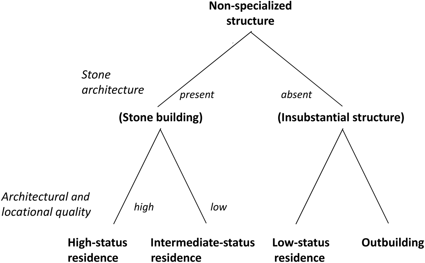
Figure 1. Reconstructed structure of the Teotihuacan Mapping Project (TMP) housing typology. Image by Smith.
As analyzed by Robertson (Reference Robertson2008, Reference Robertson, Ruiz and Arroyo2019), the Low-status residences have greater amounts of artifacts and construction stone on the surface and tend to be located nearer to the outskirts of the city, whereas the Outbuildings have fewer surface artifacts and tend to be located closer to apartment compounds. We follow Robertson in considering only the former to be residences. It is likely that both types of structure were small buildings of adobe brick, wattle-and-daub, or other perishable materials. It should be noted that the small red squares identified as “Modest or Insubstantial Structure” on the Millon map include localities assigned to both sets of architectural/functional codes.
Millon divided stone-walled buildings into Intermediate- and High-status residences. The basic unit of housing, the apartment compound, was labeled as the Intermediate-status residence. High-status residences were separated based on some (unspecified) combination of the following features: location close to the Avenue of the Dead; evidence of high-quality architecture (lime plaster and cut stones); and presence of wealth or status markers such as mural paintings. We do not know how the TMP category of “Residence of indeterminate status” fits into this scheme: are these a type of stone building, or a type of residence? The decision tree in Figure 1 is our own construction, based on discussions in a number of sources (Cowgill et al. Reference Cowgill, Altschul, Sload and Hietala1984, Reference Cowgill, Robertson and Sload2012; Gottscho Reference Gottscho1977).
As a separate operation, Millon began a study of residential architectural remains at Teotihuacan (these all fit in the TMP Intermediate- and High-status categories). Like his study of individual surface locations, this operation was started but never completed. Among Millon's papers in Buffalo, Smith located photocopies of plan maps of excavated compounds that Millon had evidently produced; these form the basis for some of the plans analyzed in this paper. In several publications, Millon divided excavated residences into several wealth levels that he termed social classes. For example, he identified six status levels of just the stone buildings: two levels of elite or high status, three levels of intermediate status, and one level of low status (Millon Reference Millon and Wolf1976). His example of the latter is the Tlamimilolpa apartment compound, not the non-stone buildings called Low-status residences in the Teotihuacan database. In a later publication, Millon (Reference Millon and Sabloff1981) associated the lowest class of his hierarchy with the insubstantial structures of the TMP survey. Subsequent researchers have discussed Millon's scheme, and some have made modifications and additions to Millon's scheme. Manzanilla (Reference Manzanilla, Hendon and Joyce2004), for example, adds a seventh (and lowest) category that includes a single example.
While Millon's published scheme might contain useful information on the relative wealth or status of the included compounds, we do not find it a useful guide to social classes or to major status groups for two reasons. First, systems of multiple social classes are quite rare in premodern states, which tend to have a small elite class (ca. 5 percent of the population) and a much larger class of commoners (Olson and Smith Reference Olson and Smith2016; Trigger Reference Trigger2003). Gradations of wealth or status within social classes are found in most premodern states, including Teotihuacan (Robertson Reference Robertson2001, Reference Robertson2015). Second, the size of the sample Millon drew on was far too small to reliably identify that number of ranked categories. One of his categories has three examples, one has two examples, three have only a single example, and one has no examples at all. We have revived Millon's program of analyzing the excavated residences of Teotihuacan—this paper is our first on this topic—but we prefer to retain the original housing typology of the TMP instead of Millon's unlikely six-class scheme.
Tests of the TMP Housing Typology
At first glance, it may seem unlikely that a housing typology based entirely on surface finds made during fieldwork in the 1960s would withstand the test of time. But, in fact, several tests of this typology over the years provide strong support of its basic validity. The first three tests are independent statistical evaluations of the distinctiveness of the housing types in terms of their quantified artifact collections. The fourth test is our new evaluation of the results of excavations of structures carried out after the initial classification of their surface remains by Millon and Cowgill for the TMP datafile. All four tests support the validity of the typology in two dimensions: first, the distinctiveness of the three types is confirmed; and, second, their interpretation as an ordinal scale of wealth or status is supported.
First test
The first statistical test of the TMP housing typology was carried out by Smith (Reference Smith1975) in his senior honors thesis at Brandeis University. Under Cowgill's direction, Smith used discriminant functions analysis to evaluate the distinctiveness of four architectural categories in terms of their artifacts: Low- Intermediate-, and High-status residences and Temples. Smith began with a preliminary sample consisting of all cases in the data file with more than 50 sherds. The Intermediate-status residence category was far larger than the others, so a systematic sample of one-sixth of these collections was taken. This yielded a sample of 360 Low-status, 217 Intermediate-status, and 147 High-status residences, plus 261 temples. Using the program “Dispersion/Discriminant Analysis” by John Rhoads (Biometric Software Laboratory, Program PM002), three discriminant functions were extracted. Together, they explained 52.2 percent of the variance. The first function, which explained 67 percent of the total discriminatory power, clearly put the three status categories into the correct order (Figure 2).
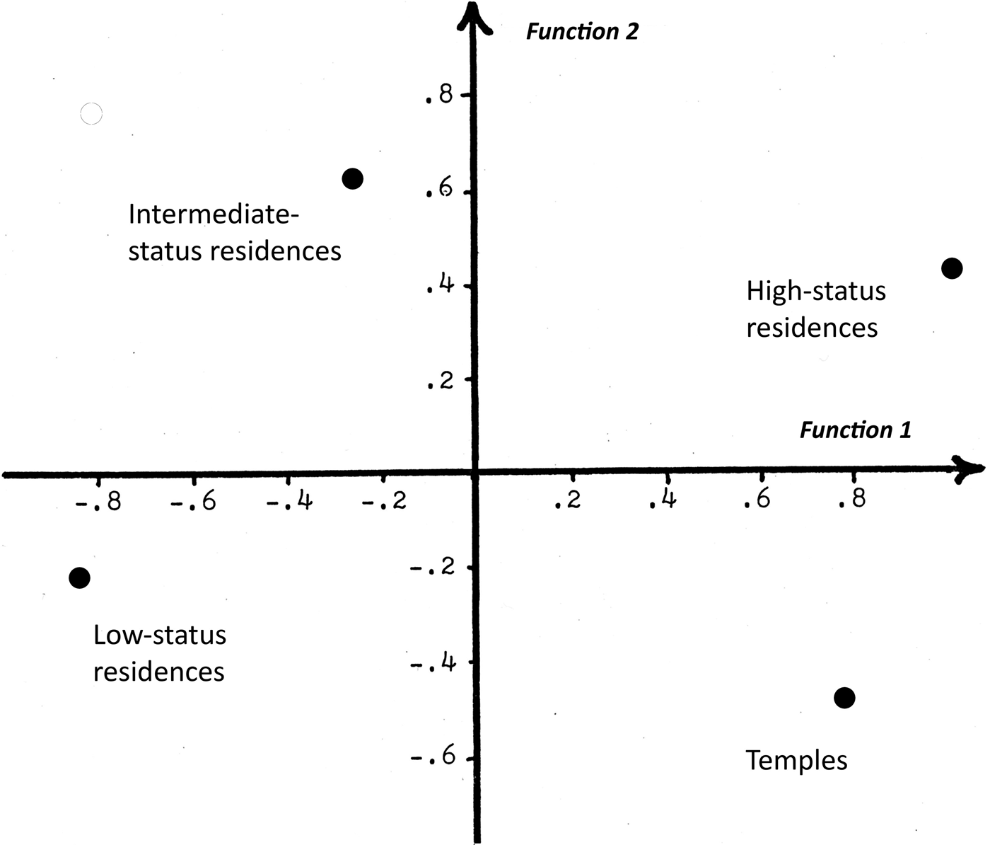
Figure 2. Group centroids from discriminant analysis of residences and temples as distinguished by their artifacts (from Smith Reference Smith1975).
Among the artifact categories with a positive correlation with the first discriminant function (and thus an association with high wealth or status) are handled covers (0.42), Metepec total (0.40), regular Thin Orange (0.31), and almenas (0.25). Categories with a negative correlation with that function are ollas (-0.42), manos/metates (-0.30), and puppet figurines (-0.28). The two basic conclusions of that analysis from 1975 were the following. (1) The categories of residences and temples can be distinguished on the basis of their artifacts alone. That is, the discriminant functions can accurately classify structures into the four categories using just the surface artifact quantities. (2) The three ranks of residence are arranged into their correct order by their artifacts alone (Figure 2). These results provide support for functional or social validity of the initial TMP typology of houses. See Smith (Reference Smith1975) for details of the data and analysis. A subsequent analysis of almenas from the TMP reported greater frequencies of houses with almenas among High-status residences than with the other categories (Smith and Paz Bautista Reference Smith and Bautista2015). The primary weakness of this analysis is that it did not control for chronological differences among collections.
Second test
Shortly after Smith's analysis, Sload (Reference Sload1982) carried out additional tests of the artifacts associated with the TMP residence types during the Xolalpan and Metepec phases. As reported in two publications (Cowgill et al. Reference Cowgill, Altschul, Sload and Hietala1984; Gottscho Reference Gottscho1977), these analyses omitted temples and also divided both the Low-status and High-status categories into two subcategories. Low-status residences were divided into cases close to apartment compounds and cases distant from apartment compounds. High-status residences were divided into “high-status room groups” and “high-status apartment compounds.” While Sload's discriminant analysis did separate or discriminate among these groups by their artifacts, we have chosen not to use her subcategories for several reasons. First, no attempt was ever made to incorporate the new types into the TMP database. While it would be easy enough today to subdivide the Low-status residences on spatial criteria, these groups were not strongly separated in the discriminant analysis (Gottscho Reference Gottscho1977:11). The two groups of High-status residences were more strongly distinguished by their artifacts, but the identification criteria are vague and it would be difficult or impossible to extrapolate this distinction to the entire sample of High-status residences in the database. Nevertheless, the three categories of residence used in this paper do show the correct ranked order in Sload's (Gottscho Reference Gottscho1977:11) discriminant analysis. Because of its more restricted chronological focus, this paper supports the notion that Smith's findings were not a product of temporal changes.
Third test
Independent of the earlier work of Smith and Sload, Robertson carried out a number of analyses relating patterned variation in the distribution of Teotihuacan surface artifacts to structure types. In one study (Robertson Reference Robertson, Ruiz and Arroyo2019), he used correspondence analysis to examine relationships between different kinds of residences (as well as other structures) and TMP interpretations of status. The analysis produced a dimension of variation that clearly ordered residence types according to likely wealth or status level.
Fourth test
The fourth test of the TMP housing typology is based on a new catalog of the excavated residences at Teotihuacan (Smith and Stewart Reference Smith and Stewart2018). The locations of these structures are shown in Figure 3. Structures were classified using the typology shown in Table 1: the three status levels of the TMP, plus two new categories (Civic compound and Temple housing). This new typology is discussed in greater detail below.

Figure 3. Teotihuacan Mapping Project (TMP) map of structures at Teotihuacan, showing excavated residences. Image by Forest and Huster.
TMP archaeologists have made a number of subjective assessments of the accuracy and usefulness of their initial housing typology. Cowgill (Reference Cowgill2015:155), for example, writes, “[o]n the whole, accuracy and validity of the original TMP survey have been shown to be quite high in subsequent excavations.” To enable a more detailed and precise evaluation, we assembled the information portrayed in Table 2, which includes all structures in Smith's catalog excavated after 1966. Because the TMP data file was not updated to reflect information from non-TMP excavations, these 36 structures provide a test of the TMP housing typology. We consider 28 out of 34 structures (82 percent) “correctly classified.” For Table 2, we are considering structures in our two new categories (Civic compounds and Temple housing) as High-status residences. Those new categories did not exist in 1966 and they represent a recent refinement of the category of elite or High-status residence. We also include under correctly classified five “partially correct” results: three residences classified by the TMP as of uncertain status were shown to correspond to the Intermediate-status category after excavation, and one remained classified as uncertain. Of the clear errors, three consist of structures called temple platforms by the TMP that turned out to be residences after excavation, and three consist of areas where the TMP found no evidence of occupation that, upon excavation, revealed residential structures.
Table 2. “Success” of the Teotihuacan Mapping Project (TMP) structure classification for residences exacavated after 1966.

a Our “Temple housing” and “Civic compound” categories are called HSR here.
b 4 uncertain status are ISR; 1 uncertain remained uncertain.
The apparent accuracy of the initial residential typology of the TMP is remarkable. It is a testament to the diligence of the TMP fieldworkers and their ability to record architectural evidence from surface remains only. This success also provides a justification for basing our new housing typology on the prior work by the TMP.
The Current Housing Typology
Our typology of excavated residences is based loosely on that of the TMP, modified through analysis of house plans. We retain the label “status” for the graded architectural types in order to maintain continuity with prior work on the TMP. Nevertheless, we view the distinctions between these categories as reflecting wealth more strongly than status. Status refers to prestige: the way individuals evaluate the relative standing of other individuals. Prestige is very difficult to study archaeologically; how can we devise a rigorous measure of what some people thought about other people long ago? The term status is also used by some archaeologists as a vague term for some kind of vertical ranking that avoids the necessity of discussing wealth differences. Household wealth, on the other hand, has a clear and strong archaeological proxy with considerable comparative and theoretical support: the size of houses. The evidence in support of this measure is cited in Olson and Smith (2001), Kohler et al. (Reference Kohler, Smith, Bogaard, Feinman, Peterson, Betzenhauser, Pailes, Stone, Prentiss, Dennehy, Ellyson, Nicholas, Faulseit, Styring, Whitlam, Fochesato, Foor and Bowles2017:Supplementary Online Materials), and the chapters in Kohler and Smith (Reference Kohler and Smith2018).
In order to systematize the study of the spatial attributes of houses, Smith engaged Stewart to redraw a sample of the architectural plans of excavated structures. Stewart began with the drawings Millon had made and then redrew plans of the structures used by Chatterjee in his access analysis (see below). These are part of a larger effort by Stewart to redraw plans of most of the excavated residences at Teotihuacan. This effort has three goals: (1) to provide a standard set of conventions for all plans including a standardized scale and rendering style; (2) to make sure key features (such as recessed patios) are correctly identified and consistently indicated; and (3) to identify patterns of architecture and layout in the residences.
These new plans required assembly of multiple published and unpublished versions of each structure's plan to create a composite sketch of the overall structure. While there were some ambiguities throughout the project—in particular, concerning recessed floors, patios, and doorways—most were resolved through consultation between Stewart, Chatterjee, and Smith.
Although our housing typology includes the three major categories of the TMP, Smith assigned the excavated structures to types without knowledge of their original TMP designations. Only two Low-status residences have been excavated, at sites San José 520 and 15:N1E6 (Cabrera Cortés Reference Cabrera Cortés2006, Reference Cabrera Cortés2011; Robertson Reference Robertson2008, Reference Robertson, Ruiz and Arroyo2019). Given that the TMP identified more than 500 of these locations at the site, their lack of study has to be seen as a significant deficiency of the current sample of excavated residences at Teotihuacan.
Classification of the excavated stone residences proceeded as follows. Smith started off by considering all excavated residences as of intermediate status, and then changed some to high status. This process results in a high level of variability in the category of Intermediate-status residence (Figure 4). Most of these structures can be labeled apartment compounds. For the category High-status residence, Smith began with the criteria of the TMP: high architectural quality and location near the Avenue of the Dead. As Stewart and Chatterjee proceeded with their drawings and analysis, the authors would meet to discuss the housing typology in light of new information. This led to a refined definition of excavated High-status residences that focuses on their layout and spatial organization (Figures 5 and 6). As noted above, in some early TMP studies, this category was divided into two subcategories. Cowgill et al. (Reference Cowgill, Altschul, Sload and Hietala1984:5) call these “Apartment compounds larger than 50 meters on a side” and “High status room groups … located within 250 meters of the Street of the Dead.” We do not consider this distinction sufficiently clear to use it here.

Figure 4. Excavated Intermediate-status residences (a) Tetitla (#A2) and (b) Xolalpan (#A1). Numbers in parentheses are catalog numbers from Smith and Stewart (Reference Smith and Stewart2018). Images by Stewart.

Figure 5. Excavated High-status residences (a) Quetzalpapalotl Palace (#A32) and (b) Ciudadela, structure 1C (west; #A31). Images by Stewart.

Figure 6. Excavated High-status residence: West Plaza (#A46). Image by Stewart.
In addition to the three basic housing types, we also defined two additional types. The first, Civic compound, is defined as a large, walled compound that contains both residential quarters and temples or shrines, in which patterns of spatial access differ significantly from those of Intermediate- and High-status residences. The three excavated examples of this type are the Xalla Compound (Figure 7), the Plaza of the Columns, and the Structure Northwest of the Río San Juan. Although the Ciudadela compound might fit this definition in formal terms, we do not include it because it is much larger than any of the other Civic compounds. Instead, we classify the residential compounds or room groups within the Ciudadela separately.
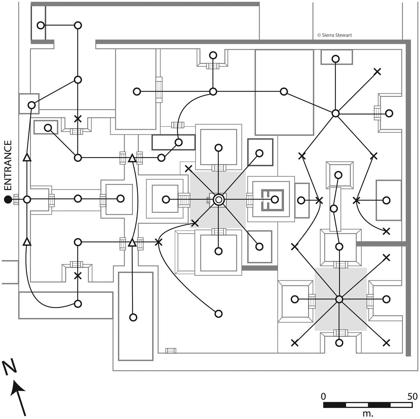
Figure 7. Xalla compound (Civic compound, #A38) with network analysis. Image by Stewart and Chaterjee.
The room blocks inside the Ciudadela, north and south of the Feathered Serpent Pyramid (structures 1D and 1E) are examples of our fifth housing type: Temple housing. This type is defined as walled compounds with highly symmetrical and formal repeated dwellings located adjacent to a major temple. Other examples include several residential compounds incorporated in the Plaza 5′ (“5 Prime”) temple compound (Figure 8) and a small room block adjacent to the Patio of the four small temples.

Figure 8. Excavated Temple housing: Group 5' (#A43). Image by Stewart.
Dwellings: Fitting Households into Apartment Compounds
The residences of Teotihuacan show many spatial regularities, although their internal organization is far from standardized. Simple visual examination is rarely sufficient to understand their layout. Some investigators have used network analysis and space syntax methods (Hillier and Hanson Reference Hillier and Hanson1984) to formulate access patterns in plans of the compounds and have drawn functional and historical conclusions (Hopkins Reference Hopkins, McClung de Tapia and Rattray1987a, Reference Hopkins1987b; Morton et al. Reference Morton, Peuramaki-Brown, Dawson and Seibert2012; Robb Reference Robb2007). We apply these methods not to characterize whole compounds with network indices, but rather to address three specific questions: (1) What were the principles that structured residential space in Teotihuacan housing? (2) Can we use these principles to identify the specific spaces (dwellings) that housed individual households? (3) Are there systematic differences in the layouts, or the spatial principles, between Intermediate- and High-status residences?
We employ the concept “dwelling” to refer to the space that housed a single household, whether simple or complex, nuclear or extended (Smith Reference Smith2014; Tipple et al. Reference Tipple, Amole, Korboe and Onyeacholem1994). At Teotihuacan, dwellings included both private residential space and semi-public space that was likely shared among the households of an apartment compound. Some researchers have used the term subcompound to refer to dwellings at Teotihuacan (Linné Reference Linné1934; Séjourné Reference Séjourné1966); we prefer dwelling because it is an established concept in the literature on comparative housing.
Identification of Dwellings Using Network Analysis
Seventeen apartment compounds were selected for network analysis: eight Intermediate-status residences, five High-status residences, two Temple residences, and two Civic compounds (Table 3). This sample consists of all Intermediate- and High-status residences that match two criteria: (1) the residences were completely excavated with a published plan; and (2) we felt secure in our ability to interpret the architectural details from the plan. The analysis was designed and carried out by Chatterjee, based on a combination of graph-theory statistics (Kansky Reference Kansky1963) and space syntax methods (Hillier and Hanson Reference Hillier and Hanson1984). The building blocks of this analysis are convex spaces and depths. A convex space is a space within which all locations are mutually visible and where the length and width of the space are approximately equal. Depth is a measure of the minimum number of intermediary steps or lines of movement that one must travel when moving between two convex spaces.
Table 3. Sample of residences for spatial and demographic analysis.

The residence is first transformed into a network of nodes and depths, following the approach proposed by Hopkins (Reference Hopkins1987b). This reduces each convex space—such as patios, temples, porticos, corridors, light wells, and rooms—into a single node without regard to the size or nature of the space, and all transitions between those spaces into depths, regardless of whether they are steps, doorways, or colonnades. For the present case, the nodal network is built up starting from the compound entrance along a traffic pattern permitted by the walls of the compounds. It takes into account the degree of accessibility of various areas of the compounds and continues until a dead end is reached. A nodal network can be characterized as either dendritic or connected. A dendritic network branches repeatedly without rejoining, allowing maximum privacy and minimum ease of movement. Dendritic networks create hierarchies of access. On the other hand, a completely connected network contains all possible routes, allowing great ease of movement and no dead-end spaces, thereby ensuring no hierarchy of access.
The basic dwelling form at Teotihuacan consists of a single central space, around which are arranged rooms that connect, directly or indirectly, with the central space. In most cases, the central space consists of or contains a sunken patio. Some dwellings contain an additional, secondary, sunken patio. Most Intermediate-status compounds also contain a central courtyard, often with porches and doorways to inner rooms on three of four sides. These courtyards were presumably shared among all or most residents of the compound. High-status compounds have larger central courtyards, with less regularity in their configuration. These patterns were used to develop the following set of rules that guided Chatterjee's network analysis:
(1) A particular convex space can belong to only a single dwelling; there are no cases of convex spaces that overlap between two dwellings.
(2) Adjacent dwellings cannot share more than one doorway. If adjacent dwelling areas share two or more doorways, they are joined into a single dwelling.
(3) Space within a dwelling is oriented around a central convex space (which typically consists of a sunken patio).
(4) Rooms immediately adjacent to a compound's central courtyard should not be considered as part of a dwelling.
The number of rooms, patios, depths, doorways, and dead ends are counted and multiple dendricity metrics are calculated for each dwelling, such as number of alternate routes, percent redundancy, normalized doorway ratios, and normalized dead-end ratios. Figures 9 and 10 illustrate the methods used. The inset in Figure 9 shows the various space syntax units using Dwelling 4 of Zacuala as an example. Percent redundancy is the ratio of number of circuits present to the total theoretical number of circuits possible for a given set of nodes (Kansky Reference Kansky1963). High-status residences such as Palace of the Jaguars, Ciudadela 1C (west), Palace of the Sun, and the West Plaza have one or more rows of attached rooms that communicate directly with the central compound open space but are not directly connected to the dwellings. These rooms have single depths that terminate in a dead end and do not have any dendritic branches. This feature prevents them from being classified as belonging to an individual dwelling. Hopkins (Reference Hopkins1987b) has postulated that these rooms were not public and would have served some auxiliary purpose. We propose that these rooms were used for storage, since they resemble storage features as identified for a number of early urban traditions in their standardized form, small size, and single entrance facing the interior of a building or compound (Anders Reference Anders1981; Garza Tarazona de González et al. Reference Garza Tarazona de González, León, Crespo, Beltán, Manzanilla and Rothman2016; Rickman Reference Rickman1971). It is not clear whether existing excavation data from these structures is sufficiently detailed to test this hypothesis.

Figure 9. Network analysis for (a) Zacuala (Intermediate-status residence, #A5) and (b) Palace of the Jaguars (High-status residences, #A54). Images by Stewart and Chatterjee.
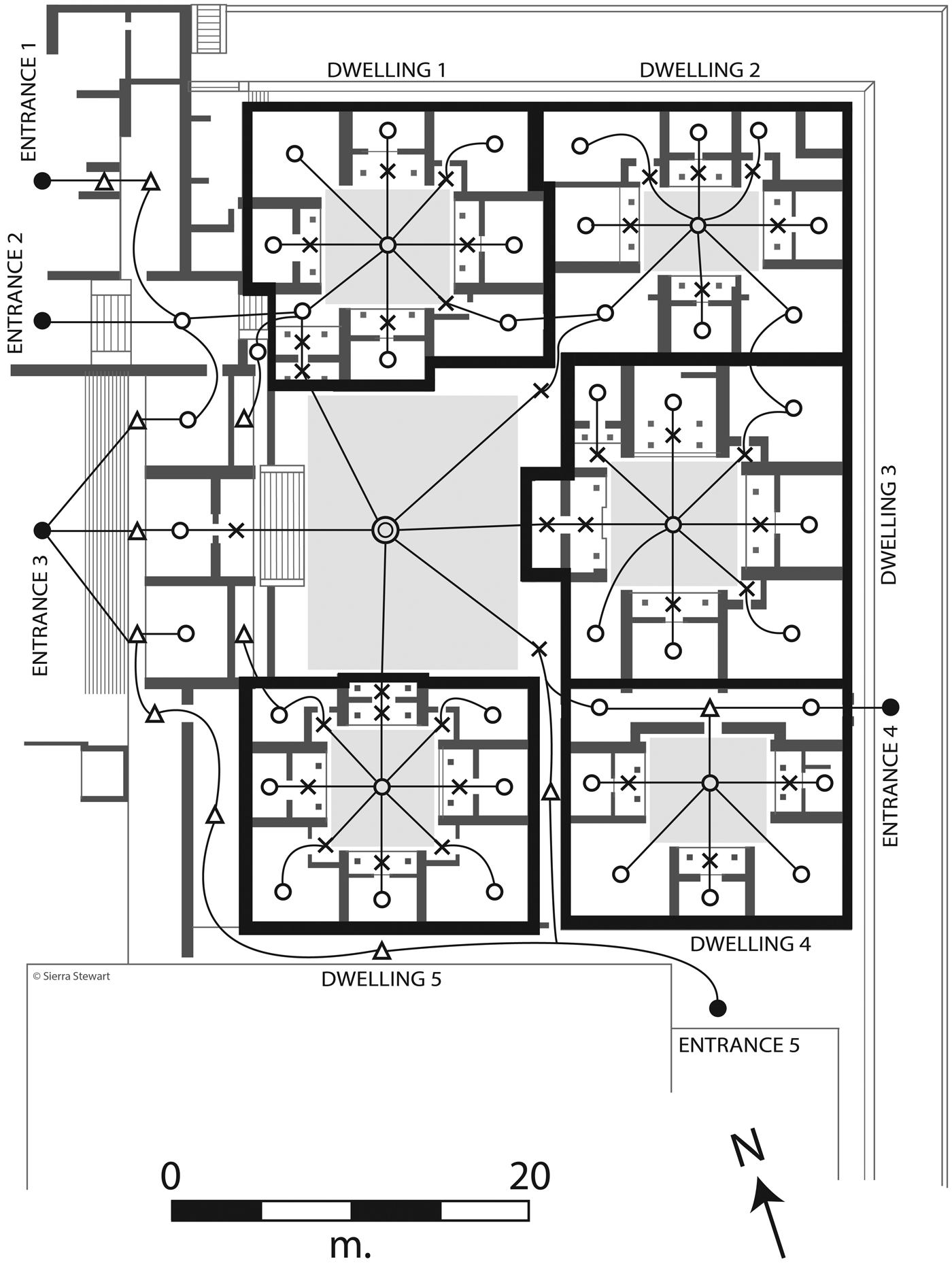
Figure 10. Network analysis of the Ciudadela, structure 1D (north) (Temple housing, #A29). Image by Stewart and Chaterjee.
Palace of the Jaguars and Conjunto del Sol have almost identical layouts with two large dwellings diagonally located on either sides of the central open space. Within the elite compounds, Quetzalpapalotl stands out with a large and impressive patio associated with a cordoned off group of rooms. The West Plaza has four distinct and large dwellings around a central open space, with the unique pattern of rows of single-depth rooms described earlier. One can argue that presence of four dwellings (a clear outlier for High-status compounds) and its unusually large total compound area make it a “complex of elite compounds,” rather than one single compound. For the sake of simplicity, we have decided to categorize it as a High-status residence with four dwellings. Unlike Intermediate-status compounds, dwellings in High-status compounds are spatially separated from one another with non-residential spaces in between. Intermediate-status residences, on the other hand, have multiple dwellings adjacent to each other and appear more “cluttered” than elite compounds. Intermediate-status residences and Temple housing compounds have a central common space but lack the distinctive rows of single-depth rooms of the High-status compounds.
Civic compounds such as Xalla and Conjunto Noroeste del Río San Juan have significant spatial depths but very few doorways and dead ends. In space syntax terminology, they are highly connected with a low hierarchy of space. Nodal analysis reveals hardly any “rooms” where people could have resided. This is the primary reason we did not delineate dwellings for individual residential units in civic structures (Figure 11). We propose that these compounds were likely used for administrative or special purposes where privacy was of lower concern. Manzanilla (Reference Manzanilla and Robb2017c) interprets Xalla as a possible royal palace, an interpretation that is compatible with our results.
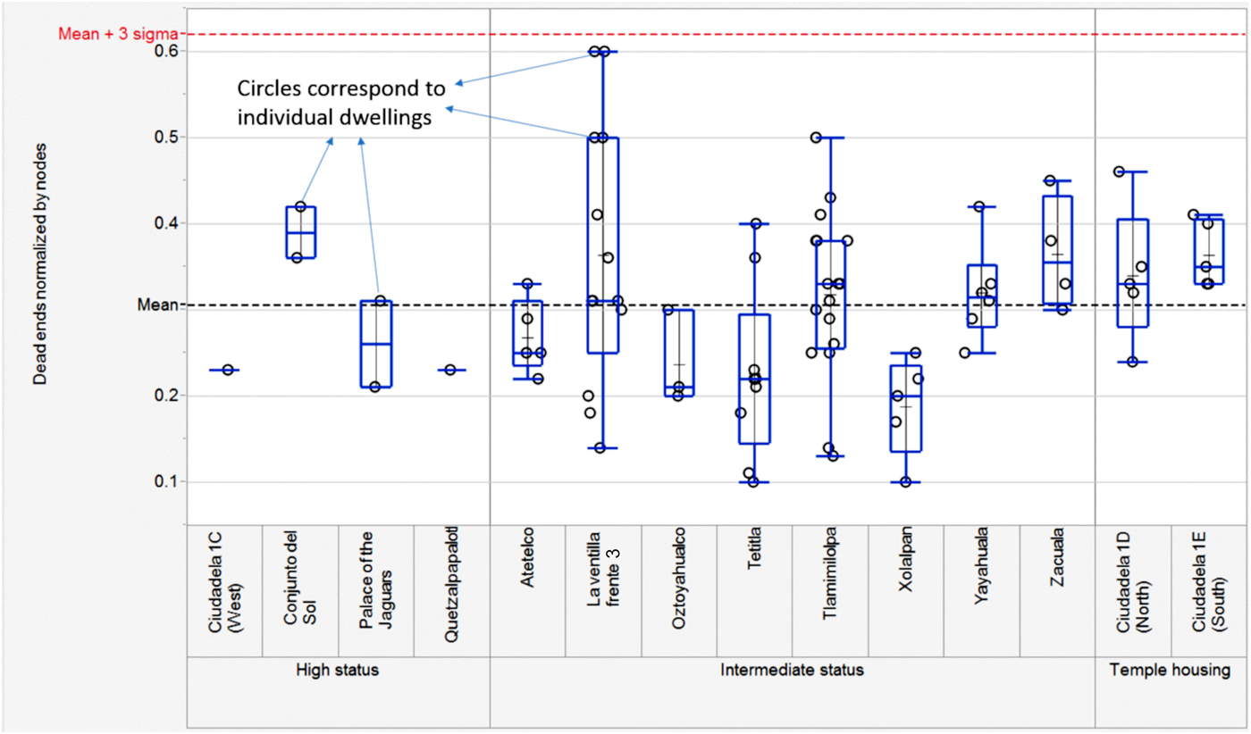
Figure 11. Graph of the number of dead ends per dwelling, arranged by excavated compound. Figures are normalized for the number of total nodes per dwelling. Horizontal lines show the mean and 3-sigma range. Graph by Chatterjee.
The architecture of temple housing compounds is unique in the high level of formality and repetition of their dwellings (Figure 8). They tend to have one relatively large dwelling located to the east of the central open space (Figure 10), with “wings” of smaller dwellings attached to either ends of the larger dwelling. This specific arrangement of convex spaces is not found in other compounds. Furthermore, the dwellings interact with the central patio through porticos, unlike the other residential compounds. Another unique aspect of Temple housing architecture is that all internal routes cross the main patio and one cannot bypass the central patio except by walking around the outside of the building (Hopkins Reference Hopkins1987b). Ciudadela 1C (west) shares common space syntax attributes with the Palace of Jaguars and Quetzalpapalotl, compared to the nearby Ciudadela 1D (north) and Ciudadela 1D (south), and is therefore categorized as an elite compound and not Temple housing in our study. Tlamimilolpa has been thought to be of low status (Millon Reference Millon and Wolf1976) but dendricity analysis does not support separating this compound from other Intermediate-status residences and creating a new, lower category. Tlamimilolpa shares a number of equivalent space syntax parameters with other Intermediate-status compounds such as Yayahuala, Xolalpan, and La Ventilla Frente 3.
Statistical Analysis of Dwellings
We investigated whether the raw distribution of space syntax metrics fall within 3 σ (or standard deviations) of the overall distribution, in order to statistically validate the dwelling demarcation exercise and its set of spatial rules. Strict adherence to these statistics will ensure that any errors are distributed across the entire sample size under study and are not skewed to a particular status level or compound. Figure 11 clearly shows that normalized dead ends for all dwellings are within mean ± 3-sigma distribution and almost matched to one another across all status levels. This essentially confirms that the basic Teotihuacan dwelling type has the same spatial signature regardless of status level and reinforces the accuracy of the dwelling definition method.
The areas of the apartment compound were calculated using the publicly available ImageJ 1.50i software (Ferreira and Rasband Reference Ferreira and Rasband2012). Comparison of mean compound area per dwelling shows significant differences between elite status compounds (1,572.9 m2) compared to intermediate compounds (391.1 m2) and Temple housing compounds (334.5 m2). Elite compounds also show a significantly higher common area (70.8 percent of total compound area) compared to intermediate compounds (38.5 percent) and Temple housing (36.5 percent). Common area reflects the compound area that is not occupied by individual dwellings, e.g., patios, light wells, courtyards, and porticos. This comparative analysis provides a numerical validation of our initial visual impression that the High-status residences seem less cluttered than others.
In order to test the statistical difference between elite and intermediate compounds, T-tests were performed on two selected parameters, total compound area per dwelling and ratio of open space to total compound area, using the JVS script on the JMP Pro 11.2.1 platform. The two-sample T-test is used to test if two populations are statistically equivalent. For the present case, a two-sided T-test with 95 percent confidence interval and α = 0.05 was used. Alpha is the significance level and is defined as the probability of rejecting the null hypothesis when it is true. The outcome of the T-test revealed P-values (significance values) of 0.0005 and 0.0027 for these values, which are lower than alpha. The statistical implication is that the hypothesis that elite status compounds are equivalent to intermediate compounds for these two variables is clearly rejected. In other words, High-status residences can be distinguished from Intermediate-status residences on some measurements, but the fundamental spatial structure of the layout of dwellings is similar in both categories.
POPULATION ESTIMATES
Population Estimates by Millon and Cowgill
Millon and Cowgill each published several estimates of the population of Teotihuacan. Given their pathbreaking construction of a complete map of the Xolalpan-phase architecture of the site (Millon et al. Reference Millon, Drewitt and Cowgill1973), it is surprising that their population estimates were based only tangentially on that map. Millon's (Reference Millon1970, Reference Millon1973:44–45) method is described succinctly by Cowgill (Reference Cowgill2015:143) as follows:
Millon estimated population by different methods. He assumed about 30 sleeping rooms in a 60 × 60 compound and 1–3 persons per sleeping room, to get 60–100 occupants. But if a compound of that size had six apartments, this would mean 10–17 persons per apartment, larger than most households in other societies. … Millon also estimated 30–50 occupants of a 40 × 40 compound and 12–20 in a 25 × 25 compound. He arrived at a minimum population of 75,000, with 125,000 more probable and perhaps more than 200,000, if his assumptions were too conservative. I think his assumptions were too generous.”
Millon (Reference Millon1973) later changed his estimate from three figures—75,000, 125,000, and 200,000—to two: 100,000 to 200,000 residents (Millon Reference Millon and Wolf1976:212).
Cowgill's most recent method of population estimation for Teotihuacan may be summarized as follows (Cowgill Reference Cowgill2015:141–143). Most apartment compounds had four to six dwellings. An estimate of six persons per dwelling yields 36 residents, whereas an estimate of 10 per dwelling yields 60 persons. Millon's estimate of 60 to 100 persons per compound seems too high. Thus, an estimate of 30 to 60 persons per compound seems reasonable. Assuming a mean between three and five households per compound yields a total of 6,900 to 11,500 households in the city. For a maximal estimate, assume five dwelling per compound and 10 persons per household; this yields 120,000 persons. Add 20,000 additional persons from Low-status residences, to arrive at a maximal estimate of 140,000. For a minimal estimate, assume that some compounds were empty and five persons per household; this yields a population of 26,000. Add 4,000 for Low-status residences, for a minimal estimate of 30,000. The midpoint of the maximal and minimal estimates is 85,000; this is Cowgill's population estimate for the city.
In a 2008 paper, Cowgill (Reference Cowgill2008a:962) had suggested (without comment) that Teotihuacan had “a population near 100,000 or possibly more.” Subsequent works by other scholars seem to have selected one of Millon's or Cowgill's figures as their preferred population estimate for the ancient city. For example, Álvarez-Sandoval et al. (Reference Álvarez-Sandoval, Manzanilla, González-Ruiz, Malgosa and Montiel2015) cite Cowgill (Reference Cowgill2008a) and Manzanilla (Reference Manzanilla2006) to justify a population estimate of over 100,000 (although the latter source lacks a demographic reconstruction), and Sugiyama and Somerville (Reference Sugiyama and Somerville2017) cite Cowgill (Reference Cowgill2008a) for an estimate of 100,000.
Extrapolating From Excavated Residences to the Entire City
In cases where population estimates are based on counts of structures (as opposed to methods based on site size or artifact densities), the resulting population estimate can be seen as the result of the interplay between three variables: the number of observed residential structures, the percentage of structures assumed to be occupied contemporaneously, and the number of occupants per structure. Calculating the latter variable at Teotihuacan requires two sub-variables. Because apartment compounds are multihousehold dwellings, estimating the population per structure involves estimating both the number of households per structure and the number of individuals per household. Additionally, because the previous section demonstrates that residences of difference classes are significantly different in size, categories of residential structures must be stratified by residential category and estimates produced separately for each.
First, we use the TMP map and associated database to calculate the number of Xolalpan-Metepec-phase residential structures at the site and assign them to residential classes. To do so, we use a GIS of Teotihuacan created by the “Service Access in Premodern Cities” project. Readers can consult the publications of that project for details of the digitizing and map construction (Dennehy et al. Reference Dennehy, Stanley, Smith and Hegmon2016; Stanley et al. Reference Stanley, Dennehy, Smith, Stark, York, Cowgill, Novic and Ek2016). The most important observation about the GIS is that the structures were digitized manually directly from a scan of the TMP map sheets, published at a scale of 1:2,000 (Millon et al. Reference Millon, Drewitt and Cowgill1973).
We begin with the observation that the distinction between Intermediate-status and High-status residences, as made by the TMP, is largely accurate and correct; this flows from both the prior tests and the network analysis presented above. For the majority of cases, we followed the TMP database assignment of residential status for apartment compounds (as High-, Intermediate-, or Uncertain-status residence). Our modestly higher counts for these residence types, compared to the TMP database (Table 1), are due to our inclusion of cases where the TMP data is incomplete (e.g., the architecture is coded as an apartment compound, but no functional interpretation is given), a non-residential function that likely co-occurred with residence was given precedence in the database (e.g., most workshops located in apartment compounds), or the database merged into one entry the artifact collections from two physical structures which were digitized separately in the GIS.
Our two new categories within the original TMP High-status residence category, Temple housing and Civic compounds, cannot be separated in the survey data at this time. Given these facts—that High-status residences make up a relatively small percentage of the total residences at the site, that both new structure types are relatively infrequent in the excavated sample, and that the two categories would have opposing effects on population counts (the former increasing and the latter decreasing estimates)—we assume their inclusion has a minimal effect on our population estimates. Residences of uncertain status are treated as Intermediate-status residences for the purposes of population estimation, since the relative frequencies of different residences of identifiable status suggest that most apartment compounds are of Intermediate-status. Additionally, the average measured compound size for uncertain-status residences in the GIS is much closer to that of Intermediate-status residences than to High-status residences.
Estimating the number of Low-status (non-apartment compound) residences features a separate set of issues, namely that different facets of the TMP identified such residences differently. As described in the earlier section TMP Housing Typology, the Millon map uses the same insubstantial structure icon for two different database categories, only one of which were likely residences. Additionally, the number of insubstantial structure icons shown within any given collection tract on the map was a rough estimate by Millon (Reference Millon1973), and he cautions that these should not necessarily be taken to indicate a precise number of structures. As a result, we use the database count of Low-status residences, rather than the map-based GIS count. The database count is probably an underestimate, since it is a count of areas with evidence of Low-status residences, some of which may have included more than one such residence. Since such lower-status adobe houses would have been significantly less durable than apartment compounds, however, it is not unreasonable to think of multiple Low-status houses in the same collection tract as representing a household series of sequential occupations.
Second, there are few analogs for estimating the degree of contemporaneous occupation at Teotihuacan, mainly because there are very few sites in the central highlands with the same degree of structural preservation. In the Maya area, it is common to assume a 10 percent disuse factor, in addition to any reductions in occupancy based on problems of the contemporaneity of occupation within a phase, which can range from 0–45 percent in modern estimations (Culbert and Rice Reference Culbert and Rice1990; Inomata et al. Reference Inomata, Triadan, Pinzón, Burham, Ranchos, Aoyama and Haraguchi2018; Ortega-Muñoz et al. Reference Ortega-Muñoz, Andrea Cucina and Sierra-Sosa2018). Given the high construction costs and durability of Teotihuacan apartment compounds, however, it is more likely that there was a certain level of sub-maximum occupancy of compounds, rather than cycles of disuse and reoccupation of entire compounds, which effectively combines the short-term disuse and longer-term contemporaneity factors used in the Maya area. This is closer to the situation observed in the southwest United States, where physical architecture will preserve (and can be subsequently reused) even in the absence of maximum occupancy. In that region, archaeological and ethnographic estimates of occupied space range from 50–80 percent of the maximum room count, with the assumption that sites occupied for longer periods of time are more likely to have sub-maximum levels of occupation on average (Hill et al. Reference Hill, Clark, Doelle and Lyons2004; Kintigh Reference Kintigh1985). While more architecturally appropriate, such estimates likely do not take into account the pressures created by the scale of urban settlement at Teotihuacan.
Burgage cycles, as seen in historic European cities, are periodic dips in population resulting in lower occupation densities within lots, rather than the contraction of the urban area or the abandonment of entire lots (Conzen Reference Conzen1969). The initial rapid growth and subsequent plateau in the size (and presumably the population) of Teotihuacan suggests that there was sufficient empty space within existing structures to accommodate changes in household composition, the arrival of immigrant households, temporary moves to accommodate repair work, and other ongoing shifts in residence. In 2018 in the United States of America, approximately 87.5 percent of housing units were occupied (United States Census Bureau 2018) and this was perceived as a tight housing market, resulting in rising rents and new construction. On the basis that the less-flexible housing provided by apartment compounds likely resulted in a higher disuse rate than in the Maya area, but that the lack of rooms used for refuse disposal during the active life of structures indicates a lower disuse rate than in the Southwest, we assume that 15 percent of available residential space at Teotihuacan was not concurrently occupied. This factor is applied at the end of the calculation process in order to facilitate the application of alternative unoccupancy rates. This disuse rate falls within the 0–25 percent range that Cowgill (Reference Cowgill2015:140–144) uses for his estimates of the population of Teotihuacan during this period.
Third, in order to calculate the number of residents per structure, we assume that our samples of excavated structures, as discussed above, are approximately representative of the populations of these classes of structures in the TMP map. This may be an optimistic assumption, but it seems to be the simplest way to proceed. For these samples, we calculated the average area per dwelling for each compound by dividing the total compound area by the number of dwellings from the network analysis. This procedure partitions the common spaces within each compound (central patio, likely ritual rooms, and corridors) equally among the dwellings in the compound. Our measure is therefore larger than the actual living area of individual households. These data are in Tables 3 and 4.
Table 4. Descriptive statistics for three categories of housing in the excavated sample.

We calculated the mean and median for the compound area per dwelling for the Intermediate- and High-status residences in the excavated samples. We next added up the total area of all residences in four categories of unexcavated structures from the TMP map: High-status residence, Intermediate-status residence, Uncertain-status residence, and Low-status residence. Table 5 shows these data and calculations. Calculations based on the median dwelling size in Table 4 are referred to as Model 1; those based on the mean are Model 2. These calculations yield an estimate of the total number of dwellings in each of the four categories. Based on the assumption that each dwelling housed a single household, we arrive at a total number of households for each of the four housing categories.
Table 5. Demographic calculations. Bolded values indicate proposed population estimates for each model.
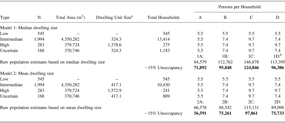
a Median or mean of square meters per dwelling.
b Preferred model (1D).
Estimating the Population
Our next step is to estimate the size of households at Teotihuacan. This is probably the weakest link in our chain of reasoning. We start with the assumption that the primary social unit at Teotihuacan—and the group inhabiting a single dwelling—was the household. Household organization is almost universal among the premodern agrarian societies of the world (Bender Reference Bender1967; Netting et al. Reference Netting, Wilk and Arnould1984), including Mesoamerica (Carballo Reference Carballo2011; Santley and Hirth Reference Santley and Hirth1993; Wilk and Ashmore Reference Wilk and Ashmore1988). While it is conceivable that residence at Teotihuacan might have been organized on some other basis (e.g., gender- or age-based quarters), we believe that the available comparative and theoretical literature make this highly unlikely.
We employ three different household-size constants to produce estimates of the population of Teotihuacan. We begin with the comparative study of Kolb (Reference Kolb1985), who surveys a large body of literature and concludes that best overall estimate for Mesoamerica is 5.5 persons per household. This happens to match rather precisely the size of peasant households in the Teotihuacan Valley in the mid-twentieth century (Charlton Reference Charlton1970; Diehl Reference Diehl1970). On this basis, we employ 5.5 persons as the lowest of our three parameters of household size. For our other constants, we turn to some of the most detailed records of conquest-era household form and size in all of Mesoamerica: a series of Nahuatl-language census documents from several towns in Morelos, compiled less than three decades after the Spanish conquest (Cline Reference Cline1993; Díaz Cadena Reference Díaz Cadena1978; Hinz et al. Reference Hinz, Hartau and Heimann-Koenen1983; Smith Reference Smith, Santley and Hirth1993). When the Morelos census towns are arranged by their dominant form of agriculture, the one town relying on terrace agriculture, Tepoztlan, had an average of 5.4 persons per house, while the five towns relying on irrigation agriculture had an average of 7.4 persons per house (Carrasco Reference Carrasco1964). Given that irrigation agriculture was practiced at Teotihuacan, we use 7.4 persons per house as our second parameter.
For a third household-size constant, we use a specific figure from the Morelos census of the community of Molotla (part of the Yautepec polity). Carrasco's (Reference Carrasco, Nutini, Carrasco and Taggert1976) data show that for joint-family households (a form of extended household), the mean number of persons per house was 9.7. This is our third and highest parameter of household size for Teotihuacan. We should note that all figures cited above are for the number of persons per house. The Molotla estimate (9.7) is specifically for joint-family households only, but the other figures include both nuclear and joint or extended families.
In Table 5, we present four scenarios for household size of the four categories of residence, labeled A through D. Scenario A uses the smallest household-size parameter for all residential categories, yielding the smallest pair of rounded population estimates: 72,000 (median) and 57,000 (mean). Scenario B uses the intermediate parameter for all but the Low-status residences, while Scenario C uses the highest parameters, yielding the highest estimates (median = 125,000, mean = 98,000). Scenario D is based on varying parameters for the residential categories.
Given the lack of normality in the distribution of mean areas per dwelling (Tables 3 and 4), the median is a better estimator of central tendency than the mean. We therefore conclude that Estimates 1A through 1D, based on the median, are more reliable than Estimates 2A through 2D. Of the four scenarios, we suggest that Scenario D is the most realistic, given the near-universal association between wealth or status and household size (Netting Reference Netting1982; Wheaton Reference Wheaton1975; Wilk and Netting Reference Wilk, McC. Netting, Netting, Wilk and Arnould1984). Therefore, our best estimate of the population of Teotihuacan in the Xolalpan phase is 96,000, which we round to 100,000.
We are currently engaged in spatial analysis of the distribution of Teotihuacan residences, and that work will be presented separately. We can report, however, a preliminary GIS-based estimate of the size of the built-up area at Teotihuacan: 1,876 ha (18.76 km2). When the population estimate of 100,000 is distributed over the built-up footprint, the resulting urban population density is 53 persons per ha. While this is considerably lower than the density of Aztec Tenochtitlan—157 persons per ha (Smith Reference Smith2008)—it is high for a Mesoamerican city (Smith Reference Smith2005).
DISCUSSION AND CONCLUSIONS
Our analyses advance two domains of Teotihuacan research. First, we have contributed to an understanding of housing and inequality by confirming the validity of the three-part residential typology of the TMP. In addition, we have identified key aspects of the spatial and social principles of Teotihuacan dwellings and compounds. Second, we have used our analyses of housing to generate the first estimate of the population of Teotihuacan that is based on the actual sizes of houses as depicted in the map of the TMP. Our analyses in both domains show the continuing usefulness of the data and concepts of the TMP, and they point the way for continuing research to complete some of the unfinished studies of that project.
The data and analyses reviewed above give strong support to Millon's initial three-category typology for Teotihuacan residences (High-status, Intermediate-status, and Low-status residences). This scheme was devised to create order in the several thousand structures documented by the surface methods of the TMP in the 1960s. It is part of a larger architectural classification system that includes temples, shrines, roads, plazas, and other features of the built environment at Teotihuacan. The non-residential architecture of Teotihuacan remains very poorly understood (apart from the major excavated pyramids), and additional research is needed badly.
We have presented three kinds of information that support the interpretation of Millon's housing typology as an ordinal scale of wealth or status. (1) Studies of associated artifacts by Cowgill and his students reached two main conclusions. First, the three house types can be distinguished on the basis of their surface artifacts alone; and, second, the rank ordering by wealth/status in the artifact data matches that of the architecture, thereby supporting the architectural classification. (2) Our assembly of information on residences excavated since 1966 (Table 2) shows that most of the excavated structures match the categories identified by the TMP. (3) Our network analysis of architecture in High-status and Intermediate-status residences confirms that the distinction between these two types is marked by distinct principles of compound layout and access. Although High-status compounds are smaller overall than Intermediate-status compounds, the dwelling sizes of High-status compounds are much larger. The fact that a typology of housing that was devised in the 1960s from surface finds remains valid and useful today is nothing short of remarkable. This is a testament to the quality of the field methods and the interpretive decisions made by Millon and other members of the TMP in the 1960s.
While our analyses support the notion that the three categories do indeed mark distinct levels of household wealth at Teotihuacan, they do not inform us of either the content or the magnitude of such differences. The artifact studies by Cowgill's students described above (Cowgill et al. Reference Cowgill, Altschul, Sload and Hietala1984; Gottscho Reference Gottscho1977; Smith Reference Smith1975) provide some clues as to the nature of distinctions among the residents of the three residential categories. But these were crude analyses that should be integrated with the results of more thorough recent analyses of the surface artifacts of the TMP (Robertson Reference Robertson2015). Additional detailed analysis of the architecture and artifacts of well-excavated compounds (Manzanilla Reference Manzanilla1993, Reference Manzanilla2012, Reference Manzanilla2017a; Ortega Cabrera Reference Ortega Cabrera, Cabrera and Avelar2013) can also contribute to a better understanding of how lifestyle, activities, and conditions may have varied among and within social classes.
Our results can be used to generate a more reliable study of the quantitative expression of wealth in equality at Teotihuacan. In a preliminary analysis, Smith et al. (Reference Smith, Dennehy, Kamp-Whittaker, Colon and Harkness2014) used the TMP map to calculate a Gini coefficient of 0.12 for Teotihuacan. This indicates a remarkably low level of wealth inequality for a major preindustrial state society, but that study did not have available the catalog of excavated residences, which was assembled after 2014 (Smith and Stewart Reference Smith and Stewart2018). This, in turn, means that extrapolation of results from excavations to the unexcavated residences was less reliable than is possible now. We intend to pursue a reanalysis of wealth at Teotihuacan using the Gini coefficient in a later paper. Supplementing our analysis of house size with estimates of construction labor (Murakami Reference Murakami2015) would be another profitable avenue of research.
Our new population estimate does not differ radically from those offered previously by Millon and Cowgill, but we feel it is based on much stronger data. As reviewed above, their population figures were based on guesses and estimates of the typical sizes of apartment compounds, whereas ours is based on the actual measured sizes in the TMP map. Cowgill (George Cowgill, personal communication 2014) was not confident of the rigor of any of those earlier estimates, including his own. His population figures had tended to drop throughout his career, with his final estimate being 85,000. Our best estimate—which can be rounded to 100,000—is close to this value, and it lies within the upper and lower bounds of Millon's various estimates for the population of the city.
The three analyses presented above have significance on two levels. Most basically, they improve our understanding of the nature of Teotihuacan dwellings, wealth inequality, and demography. On a different level, they demonstrate that continuing relevance and usefulness of the data from the TMP. For whatever reason, many of the analyses of that project were never brought to conclusion or published. But the artifacts, catalogs, datafiles, photographs, and paper records of the project are still available to scholars. We are pursuing a variety of additional lines of research using this material, and we will be archiving project data and records on the Digital Archaeological Repository (tDAR) to make them available to others (Huster et al. Reference Huster, Cabrera-Cortés, Forest, McManamon, Robertson and Smith2018). Past fieldwork at Teotihuacan still has a lot to tell us today about important issues in ancient urbanism, society, and cultural history.
RESUMEN
Presentamos tres nuevos análisis de datos existentes del trabajo de campo anterior en Teotihuacan. Primero, confirmamos y refinamos la tipología de vivienda basada en la riqueza del Proyecto de mapeo Teotihuacan (TMP) de René Millon. En segundo lugar, analizamos las configuraciones espaciales de los conjuntos habitacionales excavados, utilizando métodos de red para identificar el tamaño y el diseño de las viviendas individuales dentro de los conjuntos amurallados. Tercero, usamos esos resultados para generar la primera estimación de población para la ciudad en base a las mediciones de las estructuras del mapa TMP. Extrapolamos los tamaños promedios de las viviendas desde los complejos excavados hasta la muestra completa de residencias asignadas como se muestra en el mapa TMP de la ciudad. Generamos un rango de estimaciones de población, de las cuales sugerimos que 100,000 personas es la estimación más razonable para la población Xolalpan-Metepec de Teotihuacan. Estos análisis muestran que los datos heredados, del trabajo de campo del pasado, pueden usarse para responder preguntas de investigación que son relevantes e importantes hoy en día.
ACKNOWLEDGMENTS
The authors would like to thank George Cowgill for information, advice, and encouragement over a long period prior to the writing of this paper. Ian Robertson and Oralia Cabrera helped with crucial information on the Teotihuacan Mapping Project (TMP) and its data. Timothy Dennehy digitized the TMP architectural map that forms the basis for several of our analyses. Warren Barbour and Joshua Kwoka allowed Smith to copy René Millon's architectural plans of residences; these were the model for our redrawn plans (Stewart) and spatial analysis (Chatterjee). Melissa Marklin contributed measurements of rooms and patios at an early stage of this work, and Dean Blumenfeld measured the built-up area of Teotihuacan. Frank McManamon and Keith Kintigh played important roles in initiating our systematic consideration of the records of the TMP. The datafiles associated with this paper will be archived, along with many other project records from the TMP, in the tDAR repository. Rebecca Sload and two anonymous reviewers provided helpful criticism and suggestions. We are particularly grateful for the very detailed and helpful comments on Ian Robertson on an earlier version of this paper.


