


Introduction
The effects of global climate change may prove to be more pronounced in Antarctica than at mid-latitudes (Reference WellerWeller, 1993). Floating glaciers (ice shelves, ice tongues and glacier tongues) are sensitive to atmospheric warming, as shown by the recent spectacular break-up of ice shelves around the Antarctic Peninsula (Reference Rott, Skvarca and NaglerRott and others, 1996; Reference Vaughan and DoakeVaughan and Doake, 1996), which demonstrates the existence of an abrupt thermal limit on ice-shelf viability associated with regional atmospheric warming (Reference Skvarca, Rack, Rott and DonángeloSkvarca and others, 1998). Reference Vaughan and DoakeVaughan and Doake (1996) and Reference FrezzottiFrezzotti (1997) have pointed out that the extent of floating glaciers may well be a sensitive indicator of regional climate change. The uncertainty still existing about iceberg-calving processes makes it difficult to determine the present ice-sheet mass balance (Reference Jacobs, Hellmer, Doake, Jenkins and FrolichJacobs and others, 1992).
In this research we studied 18 glaciers that drain along Wilkes Land (Fig. 1). The coastal study area includes: the Adélie Coast, the Clarie Coast, the part of the George V Coast extending from Buchanan Bay (67°05 S, 144°30 E) to Point Alden (66°48 S, 142°02 E), which was not examined in a previous paper by Reference Frezzotti, Cimbelli and FerrignoFrezzotti and others (1998), and the portion of the Banzare Coast between Cape Morse (66°15 S, 130°10 E) and Frost Glacier (67°05 S, 129˚ E). The Adélie Coast is the portion of Wilkes Land lying between Point Alden and Pourquoi Pas Point (66°12 S, 136°11E). The Clarie Coast is the portion of Wilkes Land lying between Pourquoi Pas Point and Cape Morse. The Adélie and Clarie Coasts were discovered inJanuary 1840 by Capt. J. Dumont d’Urville, and named, respectively, for his wife Adélie and for the wife of the captain of his second ship, Clarie. The Banzare Coast was seen from the air by the 1929–31 British–Australian–New Zealand Antarctic Research Expedition (BANZARE) under Sir D. Mawson. The study area is approximately 1200 km in length. The ice shelves and glacier tongues of this area are fed from glaciers that drain the northern part of Dome C (75°06 S, 123°23 E). A description of coastline changes since 1947 is provided in this paper. Satellite image analysis of iceberg-calving frequency and ice-front change along the coast between McMurdo Sound and Porpoise Bay has provided information about ice–ocean interaction.

Fig. 1. Sketch map of Wilkes Land.
Materials, Methods And Data
Various authors (e.g. Reference Ferrigno, Lucchitta, Mullins, Allison, Allen and GouldFerrigno and others, 1993; Reference Frezzotti and MabinFrezzotti and Mabin, 1994; Reference SkvarcaSkvarca, 1994; Reference Vaughan and DoakeVaughan and Doake, 1996; Reference FrezzottiFrezzotti, 1997; Reference Frezzotti, Cimbelli and FerrignoFrezzotti and others, 1998) have shown that reliable records of ice-front changes and the velocity of floating glaciers can be obtained by combining data from historical maps and records, aerial photographs and satellite images, documenting conditions over several years to decades.
Maps drawn during the Dumont d’Urville expedition do not permit accurate identification or mapping of floating glaciers. Aerial photographs of the Adélie, Clarie and Banzare Coasts were taken by the U.S. Navy and Australian National Antarctic Research Expedition (ANARE) using the Trimetrogon aerial (TMA) camera system between 1947 and 1962. These photographs were used by the Australian Division of National Mapping to compile sketch maps of the area at a scale of 1:1000000; by the U.S. Geological Survey to compile reconnaissance maps of the Clarie and Banzare Coasts at a scale of 1:500 000; and by the Institut Géographique National Français to compile maps of the Adélie Coast at scales of 1:500 000 and 1:100 000.
In this study, we supplement the previously available data with satellite images and photos acquired by Argon (1963), Landsat Multispectral Scanner (MSS) 1 (1973–74), Soyuz Kosmos KATE 200 (1985), Landsat Thematic Mapper (TM) 4 and 5 (1989–90), European Remote-sensing Satellite-1 and -2 (ERS-1/-2) synthetic aperture radar (SAR) (1995–96) and RADARSAT 1 SAR (1997). Digital data were used when available, but were not available for the Argon, Soyuz Kosmos KATE 200 and some Landsat 1 MSS images. Therefore, the photographic products were scanned from 200 to 50 μm to obtain a digital dataset with a spatial ground resolution between 80 and 150 m. RADARSAT 1 image mosaics, with a ground resolution of 125 m, were obtained at the web site http://iceberg.mps.ohio-state.edu (Reference JezekJezek, 1999).
To enhance the topographic features in the images and reduce the noise inherent in any single band, we used the first principal component (PC1) of MSS bands (4–7), of TM bands (1–5 and 7), and removed scan-line striping. In the principal-component analysis, linear combinations of the original data bands were searched in order to maximize the variance of the data in a minimum number of components. Thus, the PC1 contains the greatest variance. Various authors (e.g. Reference Orheim and LucchittaOrheim and Lucchitta, 1987; Reference Bindschadler and ScambosBindschadler and Scambos, 1991) have shown that the PC1 produces a clearer image of ice-sheet surface morphology. Satellite image maps with a spatial resolution of 30 mper pixel were created using Landsat TM images. Images were georeferenced by identification of the ANARE and Expéditions Polaires Françaises survey control stations on the image. In the western part of the Clarie and Banzare Coasts, for which survey control- station data are not available, we used the RADARSAT image mosaic, which presents an absolute geolocation better than 100m (Reference Kim, Jezek and SohnKim and others, 2001). Georeferencing was carried out by rectifying the images in a polar stereographic projection, using a linear conversion matrix. Using these georeferenced Landsat TM satellite images as a reference, other satellite images and photographs (Argon, Landsat 1 MSS, Soyuz Kosmos KATE 200 and ERS-1/-2 SAR) were rectified by identifying about 10–15 tie points for each image pair, and using a linear conversion matrix giving an rms error of one to three pixels (30–90m).
The available maps have considerable inaccuracies that remain largely unknown. These were corrected whenever possible through reference to the satellite-derived data. The satellite images and maps of floating glaciers were analyzed, compared and organized into a geographic information system (GIS) under ERDAS IMAGINE and ARC/Info environments. The geographical positions of the ice fronts and iceberg tongues in different years made it possible to determine the positional variations of the ice fronts and iceberg tongues. The area of the floating glaciers was calculated using the ice-front positions at various dates, but always the same grounding line. Most of the glaciers have a seaward iceberg tongue; these were not countedas floating glaciers. The grounding lines of the floating glaciers were surveyed using satellite imagery (visible/infrared and SAR) by identifying linear depressions and change in surface slope that cut across glaciers. We estimate the accuracy of grounding-lineposition is around 500 m. As many of the glaciers, glacier tongues and ice shelves studied do not have officially approved names, numbers are used to identify them.
The drainage area of the basin was calculated using a digital elevation model (DEM) derived from ERS-1 radar altimeter data (Reference Rémy, Shaeffer and LegrésyRémy and others, 1999). Along the coast, where slopes are steeper, tracking was not continuous due to loss of tracking, so altimeter data were supplemented with data from digitized reconnaissance maps at a scale of 1:100 000 to 1:1000 000. In this way, a new DEM of the study area was created with a Lambert equal-area projection and a gridsize of 1km. The main catchment basin was mapped by applying standard hydrological modelling tools, included in the proprietary GIS ARC/info (version 7.2), to the new DEM inside the plateau area. The ice divide was drawn on the map using the main catchment basin outlined by DEM and satellite images (RADARSAT and Landsat TM) along the coast (Fig. 1).
Discussion
Location numbers refer to Table 1.
The glaciers in this coastal section drain the northern peripheral portions of Dome C over an area of about 270 000 km2 (Fig. 1 and 2; A: 67°10’ S, 144°32’ E; B: 67˚ S, 128˚ E). Table 1 and Figures 3 and 4 present a compilation of the areal extent of floating glaciers studied in this paper. The total area of the floating glaciers in 1963 and 1989 was 3035 and 2785 km2, respectively (Table 1). The main glaciers in the area are Zélée, Astrolabe, du Français, Commandant Charcot and Pourquoi Pas for the Adélie Coast, and Dibble, May, Sandford and Frost Glaciers for the Clarie and Banzare Coasts (Fig. 2 and 3).
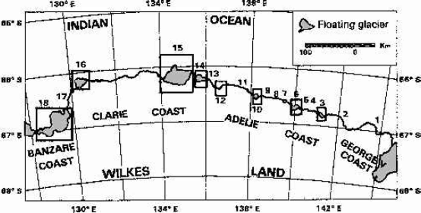
Fig. 2. Sketch map of the Adélie, Clarie and Banzare Coasts.

Fig. 3. Subscenes of satellite images showing ice-front variations for: (a) subscene of Landsat TM image (PC1, path/row 86/107, 14 January 1989) of Glacier de la Zélée; (b) subscene of Landsat TM image (PC1, path/row 86/107, 14 January 1989) of Glacier de l’Astrolabe; (c) subscene of Landsat TM image (PC1, path/row 86/107, 14 January 1989) of Glacier du Français; (d) subscene of Landsat TM image (PC1, path/row 88/107, 5 February 1989) of Glacier du Commandant Charcot; (e) subscene of Landsat MSS image (PC1, path/row 94/107, 13 October 1973) of Dibble Glacier; (f) subscene of Landsat TM image (PC1, path/row 88/107, 5 February 1989) of Pour quoi Pas Glacier; (g) subscene of Landsat TM(PC1, path/row 92/107, 2 December 1989) of Frost Glacier.
Table 1. Catalogue of floating-glacier area extent (for locations see Fig. 2)
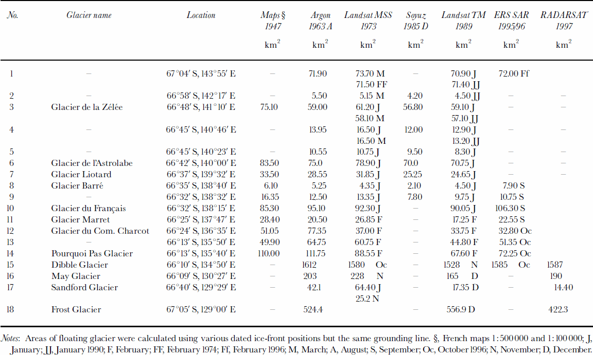
Most of the glaciers form large iceberg tongues separated from the ice front. The analysis shows a very large areal extent of iceberg tongues during the 1950s and 1960s, with a large extent of multi-year fast ice in January. It appears that the areas of iceberg tongues and multi-year fast ice have decreased since 1963.
In the period 1947–63 (Table 1; Fig. 4), there was a reduction in the area of the floating glaciers east of 138°32’ E, amounting to 10–23%. In the same period in the western part, we observed an increase in the floating-glacier area, within the range 2–34%, with the exception of Marret Glacier (–23%). The next period, 1963–73, exhibited a general stability in extent without any particular trend. An exception to this is Glacier du Commandant Charcot, which showed a reduction of 52%. Between 1973 and 1989/90, there was a general reduction in the floating-glacier area. Thereafter, during the period 1989/90 to 1996/97, the floating glaciers underwent a general advance, but without reaching the 1947 extent.

Most of the floating glaciers have shown a cyclical behaviour without a marked trend, although a general reduction since 1947 can be noted. Analogous reduction has been observed for the multi-year fast ice and iceberg tongues along the studied coast between the 1950s and 1970s. Areal reduction of the floating glaciers between the 1950s and 1970s is reported for the George V, Oates, Pennell and Borchgrevink Coasts (Reference FrezzottiFrezzotti, 1997; Reference Frezzotti, Cimbelli and FerrignoFrezzotti and others, 1998) and Dronning Maud Land ice shelves (Reference Kim, Jezek and SohnKim and others, 2001). Reference De la MareDe la Mare (1997) pointed out that the Antarctic summer sea-ice edge moved southwards by 2.8˚ of latitude between the mid-1950s and early 1970s, with a decline of some 25% in the area covered by sea ice. The agreement between the decline of sea-ice extent in summer (de la Mare, 1997) and of fast-ice, iceberg-tongue and floating-glacier extent between the 1950s and 1970s provides some confidence that changes in ice–ocean–climate interaction occurred during this period. Further work is required to establish relationships between climate, ocean, sea ice and ice-front extension.
Most of the glaciers are characterized by the proximity of the grounding line to the ice front. Some glaciers have a floating part with small or no glacier tongues as they end inside or close at the coastline, in spite of the considerable ice discharge from some of them (e.g. Dibble, du Français, Frost). Between the grounding line and the ice front these glaciers present linear depressions approximately at right angles. Icebergs form in low portions at the ice front following these linear depressions. Thus, their shape resembles a cylinder split length-wise and placed horizontally, convex face up, on the fast ice. The calving behaviour of these glaciers is characterized by an accumulation of icebergs projecting from the coast with the formation of iceberg tongues, held in place by grounding and joined together by fast ice or multi-year fast ice. Bathymetric maps (Reference Chase, Seeking, Young, Eittreim, Eittreim and HamptonChase and others, 1987) and satellite images show the presence of several small islands along the coast, and the bottom topography dominated by shallow depth contours. These morphological features could foster the formation of iceberg tongues. Reference Frezzotti, Cimbelli and FerrignoFrezzotti and others (1998) have postulated that along the George V Coast there may be an iceberg trap also related to the extremely low velocity of the coastal currents along this stretch of coast. Variations in the ice fronts of studied glaciers are very rapid (1–5 years) and seldom maintain the same shape for more than a few years. These floating glaciers are characterized by grounding lines close to the ice front, and numerous linear, snow-filled depressions and rifts that extend across the floating glacier a few kilometres downstream from the grounding line. Reference FrezzottiFrezzotti (1997) has interpreted the depressions as the surface expression of bottom crevasses. The depressions become accentuated from the grounding line to the ice front and are the preferential line of major rift formation and, subsequently, of calving.
The analysis of the ice-front changes and calving behaviour along 6000 km of coast (Reference FrezzottiFrezzotti, 1997; Reference Frezzotti, Cimbelli and FerrignoFrezzotti and others, 1998) from McMurdo Sound to Porpoise Bay has shown changes in iceberg-calving frequency (Fig. 5). From southeast (McMurdo Sound) to northwest (Clarie Coast), we observe an overall reduction of the lifetime of glacier tongues, with a calving behaviour characterized by the growth of the glacier tongues over approximately 15–50 year periods along Scott Coast and close to a coastal polynya (Drygalski Ice Tongue, Matusevich Glacier, Mertz Glacier). These glacier tongues present a grounding line of about 30– 50 km within a fjord-like valley with a deep (>1000m) sub-ice-shelf cavity (Reference FrezzottiFrezzotti, 1997; Reference Frezzotti, Cimbelli and FerrignoFrezzotti and others, 1998, Reference Frezzotti, I.E. and Zirizzotti2000). By contrast, along the Clarie and Adélie Coasts and the Cape Adare area, the variations in the ice fronts of glaciers are very rapid (yearly) and seldom maintain the same ice-front shape for more than a few years. An intermediate behaviour is observable in the floating glaciers off the Borchgrevink, Pennell, Oates and George V Coasts. The different calving behaviour of these floating glaciers could be due to ocean circulation at the ice–ocean interface mainly in the sub-ice-shelf cavities. Intrusions of warm water derived from Circumpolar Deep Water (CDW) coming from the continental slope are pointed out by Reference JacobsJacobs (1989) along the George V Coast and by Reference Jacobs and ComisoJacobs and Comiso (1989) for the Cape Adare area. Reference JacobsJacobs (1989) and Reference Frezzotti, Cimbelli and FerrignoFrezzotti andothers (1998) have hypothesizeda basal melting rate along the George V Coast of about 7–12ma–1. High basal melting rates could contribute to greater local calving by removing the less brittle lower layer of ice (Reference MacAyeal and ThomasMacAyeal and Thomas, 1986), thus rendering it more susceptible to fracture along existing rifts and bottom crevasses (Reference Shabtaie and BentleyShabtaie and Bentley, 1982). Thermohaline circulation led by High Salinity Shelf Water, formed mainly in the coastal polynya area, increases the accretion of marine ice at the base of floating glaciers along a fjord-like valley. This in turn makes the structure of the floating glacier more resistant to storms, wave motion and subsequent basal melting processes (Reference FrezzottiFrezzotti, 1997; Reference Frezzotti, I.E. and ZirizzottiFrezzotti and others, 2000). The closeness of the grounding line to the ice front, the shallow depth of sub-ice-shelf cavity and CDW intrusion could be the principal factor affecting the calving style and iceberg-tongue formation of the study glaciers.

Fig. 5. Map illustrating region of calving behaviour, between McMurdo Sound and Porpoise Bay, based on ice-front variation between 1950s and 1990s.
Acknowledgements
This research was carried out within the framework of a Project on Glaciology of the Programma Nazionale di Ricerche in Antartide, and was financially supported by Ente per le Nuove Tecnologie, l’Energia e l’Ambiente (ENEA) through a cooperation agreement with the Università degli Studi di Milano-Bicocca, and by the European Union under grants ENV4-CT95-0124. The Landsat TM images were obtained through a programme sponsored by an international consortium of nations that are members of the Scientific Committee on Antarctic Research (SCAR) Working Group on Glaciology. The ERS images were made available at research cost by the European Space Agency. The RADARSAT-1 mosaic was obtained at the web site http://iceberg.mps.ohio-state.edu. Thanks are due to T. Scambos, B.H. Raup and R. A. Massom whose comments and editing helped to improve the manuscript.


