Introduction
We are using in-situ produced cosmogenic nuclides to resolve the vertical and lateral extent of ice margins in the eastern Canadian Arctic during Wisconsinan glaciations. We measured Be10 and 26Al abundances in > 140 samples of glacially molded bedrock and erratic boulders collected from the Pangnirtung Fiord area of Baffin Island (Fig. 1; Reference MarsellaMarsella, 1998). Our data suggest that late Wisconsinan (Stage 2) glaciation in the Pangnirtung Fiord area was much more extensive than previously believed (Reference DavisDavis and others, 1995, 1996a, b; Reference Marsella, Davis, Bierman, Finkel, Caffee and SouthonMarsella and others, 1995, Reference Marsella, Bierman, Davis and Caffee1996; Reference MarsellaMarsella, 1998; Reference Bierman, Marsella, Patterson, Davis and CaffeeBierman and others, 1999).

Fig. 1. Map showing Crater Lake in Pangnirtung Pass (PP) on Cumberland Peninsula (CP on inset), Pangnirtung hamlet (P), Pangnirtung Fiord (PF) and Kingnait Fiord (KF). Thin line segments along the sides of Pangnirtung Fiord are late-Wisconsinan age Duval moraines.
Cosmogenic nuclide inheritance from prior exposure can produce erroneously old ages in both bedrock or boulder samples. To evaluate the likelihood of such inheritance in our Baffin Island dataset, we collected and analyzed seven samples, all of which were exposed from under Tumbling Glacier by ice retreat during the past 20 years. We collected samples from the striated tops of two roches moutonnées (n = 4), from cobbles sitting on top of each roche moutonnée (n = 2) and from a boulder sitting between the sampled outcrops (n = 1). Because these samples were exposed from under the ice after 1976, they should contain nuclide abundances below the detection limit unless nuclides were inherited from a prior period of exposure. In addition, we sampled two boulders on the Neoglacial moraine of Tumbling Glacier, which impounds Grater Lake. Licheno-metric studies (Reference Davis and AndrewsDavis, 1985) suggest that these moraine boulders should have no more than several hundred years of exposure (Fig. 2). This paper reports the results of our test.

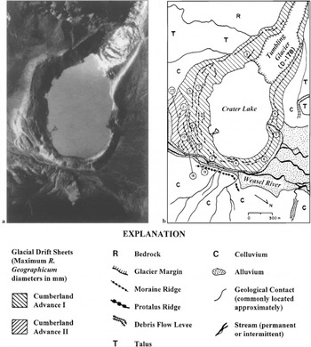
Fig 2. Tumbling Glacier, Crater Lake and Neoglacial moraines, (a) Part of vertical air photograph showing bergs calving from Tumbling Glacier into Crater Lake (Government of Canada, A16817-29, 1959).(b) Moraines impounding Crater Lake. Licheno- metric data (circled numbers are diameters in mm) indicate at least two advances (Cumberland Advances I and II) occurred during the late Neoglacial, spanning about the last 400yr. Protalus ridge originated from mass movements on valley side across Weasel River from Crater Lake and is probably late Wisconsinan in age.
Background
Until recently, most workers believed that Pangnirtung Pass (Fig. 1) and most fiords along the east coast of Baffin Island were not glaciated during the late Wisconsinan (Reference ThompsonThompson, 1957; Reference Miller and DykeMiller and Dyke, 1974; Reference AndrewsAndrews, 1975, Reference Andrews, Ruddiman and Wright1987; Reference DykeDyke, 1977, 1979; Reference IvesIves, 1978; Reference Dyke and PrestDyke and Prest, 1987) and thus the late Wisconsinan ice margin is depicted well to the north of our sample site at Grater Lake by Reference Dyke, Andrews and MillerDyke and others (1982). This view of limited ice extent in the eastern Canadian Arctic has been the major objection to an extensive Arctic ice sheet during the late Wisconsinan (Reference Hughes, Denton and GrosswaldHughes and others, 1977; Reference Denton and HughesDenton and Hughes, 1981; Reference Mayewski, Denton, Hughes, Denton and HughesMayewski and others, 1981). However, Reference JenningsJennings (1993) and Reference Jennings, Tedesco, Andrews, Kirby, Andrews, Austin, Bergsten and JenningsJennings and others (1996) determined that late Wisconsinan glacial ice filled Cumberland Sound (Fig. 1), extending about 400 km beyond the late Wisconsinan ice margin shown in Reference Dyke, Andrews and MillerDyke and others (1982). A more-extensive late Wisconsinan ice margin in the Cumberland Sound area is also consistent with the recognition of Heinrich events in the Labrador Sea (Reference Andrews, Erlenkeuser, Tedesco, Aksu and JullAndrews and others, 1994, 1995; Reference Jennings, Tedesco, Andrews, Kirby, Andrews, Austin, Bergsten and JenningsJennings and others, 1996).
Only very recently has accelerator mass spectrometry (AMS) radiocarbon dating begun to resolve the age of terrestrial Arctic landscapes (Reference Abbott and StaffordAbbott and Stafford, 1996). Although radiocarbon ages from lake-sediment cores in lowlands and floors of glacial valleys are consistent with late Wisconsinan ice cover (Reference Short, Mode, Davis and AndrewsShort and others, 1985; Reference Lemmen, Gilbert, Smol and HallLemmen and others, 1988), some lake-sediment records from uplands in the Pangnirtung Fiord area indicate that higher areas may have been nunataks during the late Wisconsinan (Reference WolfeWolfe, 1996; Reference Wolfe and HartlingWolfe and Härtling, 1996). Our larger dataset of > 140 cosmogenic nuclide exposure ages for the Pangnirtung Fiord area (Reference MarsellaMarsella, 1998; Reference Bierman, Marsella, Patterson, Davis and CaffeeBierman and others, 1999) suggests a long and complex burial and exposure history for upland surfaces, but does not rule out the possibility of cover by cold-based ice during the late Wisconsinan (cf. Reference Hughes, Denton and GrosswaldHughes and others, 1977; Reference SugdenSugden, 1977; Reference SugdenSugden and Watts, 1977).
Although interpretations of late Wisconsinan ice margins in the Pangnirtung Fiord area have been contentious, there is general agreement that local glaciers on Baffin Island readvanced during Neoglaciation (Reference MillerMiller, 1973; Reference Andrews and BarnettAndrews and Barnett, 1979; Reference DavisDavis, 1980, 1985, 1987). The development of growth curves for Rhizocarpon geographicum s.l. on Baffin Island (Reference Miller and AndrewsMiller and Andrews, 1972; Reference MillerMiller, 1973; Reference Andrews and BarnettAndrews and Barnett, 1979; Reference Davis and AndrewsDavis, 1985) has allowed discrimination of multiple glacier advances during the last 3000–4000 yr. The most recent Neoglacial advances, which correlate with the Little Ice Age (Reference MillerMiller, 1973; Reference Davis and AndrewsDavis, 1985), are commonly the most extensive on Baffin Island and thus much of the earlier part of the Neoglacial record is obliterated. However, proxy climate records less prone to obliteration, such as lichenometrically dated debris-flow levées (Reference Davis and FabelDavis and Fabel, 1988) and radiocarbon-dated debris-avalanche sediments in a lake (Reference Davis and AndrewsDavis and Kihl, 1985), accord with multiple glacier advances during Neoglaciation.
Palynological analyses of lake-sediment cores from Baffin Island also indicate cooling during the last 4000–5000 yr, following a warmer early Holocene (Reference DavisDavis, 1980; Reference Andrews, Mode and DavisAndrews and others, 1980, Reference Andrews, Davis, Mode, Nichols and Short1981; Reference Short, Mode, Davis and AndrewsShort and others, 1985). Other continuous records of Holocene climatic change in the Pangnirtung area include analyses of diatoms in lake-sediment cores, which also indicate early Holocene warming followed by Neoglacial cooling (Reference WolfeWolfe, 1996; Reference Wolfe and HartlingWolfe and Härtling, 1996). The rapid retreat of glaciers and ice caps on Baffin Island during the past two decades is consistent with larger data bases that suggest global warming (Reference Mann, Bradley and HughesMann and others, 1998).
Site Location
The moraines impounding Crater Lake (Fig. 2) in southern Pangnirtung Pass all date to the latter part of the Little Ice Age (Cumberland Advances I and II) and probably obliterated earlier Neoglacial moraines, which are found fronting glaciers elsewhere in Pangnirtung Pass (Reference DavisDavis, 1980, 1985). When air photographs were taken of Pangnirtung Pass in 1959, Tumbling Glacier extended into Crater Lake. By 1976, Tumbling Glacier had retreated, but glacier debris or a floating ice tongue still extended beyond the near-vertical snout. However, by 1994, the margin of Tumbling Glacier had retreated sufficiently to expose a promontory of fresh, quartz- rich gneissic bedrock extending across Crater Lake, about 100 m beyond the current ice margin (Fig. 3). The roches moutonnees, boulders, and cobbles exposed on this rock shelf, as well as two gneissic boulders cropping out on the Neoglacial moraine, are the focus of the study reported here.

Fig 3. Oblique air photograph (1994) looking northwest at snout of Tumbling Glacier, which has retreated about 100 m since 1976, exposing a promontory of roches moutonnées and overlying glacial boulders. Ice margin from 1959 (Fig 2) and 1976 shown by dotted line. Numbered cosmogenic nuclide sample sites shown in more detail in Figure 4.
Methods
We used hammers and chisels to sample the tops of freshly polished and striated bedrock and boulders, avoiding edges with steep sides. Sample thickness (15–50 mm) and topographic shielding were measured in the field. We used standard methods to purify quartz and chemically purify Be and Al (Reference Kohl and NishiizumiKohl and Nishiizumi, 1992; Reference Bierman and GillespieBierman and Gillespie, 1995).
Our laboratory procedure involved sample processing in batches of eight, one process blank and seven samples. For each sample, 26–43 g of quartz was dissolved, to which we added 250–300 μg of commercial Be carrier (SPEX brand), quantitatively. Stable Al was measured by ICP—OE (inductively coupled argon plasma spectroscopy, optical emission) in aliquots of solutions used to prepare targets for isotopic analysis. Reported measurements are averages of duplicate analyses made on two different dilutions, each corrected to three internal standards spanning the range of observed concentrations. Because sample quartz contained from 91— 141 μg g—1 stable Al, no Al carrier was added except to the process blank. Process blanks contained only Al (2000 μg) and Be (250–300 μg) and were subjected to the same chemical procedures as actual samples.
Ratios of 10Be/9Be and 26Al/27Al were measured for each sample and process blank using AMS at the Lawrence Livermore National Laboratory (LLNL). Each target was measured at least twice and compared to at least three analyses of LLNL laboratory standards. For Be, a correction was made for the interference caused by 10B, an isobar of Be. This correction is based on the ratio of gated counts to total counts in a target spiked with B but known to contain only low levels of Be. When the boron correction is made, a 50% uncertainty on this correction is propagated quadratically. For all but two of our samples, more than 75 % of the gated counts were attributed to 10Be; for the other two samples, 61 % and 67% of the gated counts were attributed to 10Be (F.O.M. [figure of merit], Table 1).
Table 1. Isotopic data for Crater Lake samples, Baffin Island.

To estimate isotopic ratios in our nine samples, the ratio measured in the appropriate process blank was subtracted from ratios measured in samples. Nuclide abundance was so low in these samples, that for seven of the nine 10Be measurements, we could only determine upper limits for 10Be/ 9Be. For 26Al, our sensitivity was higher and finite isotopic ratios (26Al/ 27Al) were measured in five of the nine samples. Upper limits for isotopic ratios were calculated by subtracting the isotopic ratio of the process blank from the measured sample isotopic ratio and propagating the uncertainty quadratically. If the resulting blank-subtracted ratio for a sample was more than the 2σ uncertainty, then the ratio was considered finite and the ratio and its uncertainty were reported. If the blank- subtracted ratio was less than the 2σ uncertainty, then only an upper limit for the isotopic ratio of the sample could be calculated. Upper limits were calculated by adding the 2σ uncertainty to the blank-subtracted ratio. If the blank-subtracted ratio was negative, the 2σ uncertainty was considered to be the upper limit. By using a 2σ uncertainty, there is a 95% chance that the actual ratio (and the derived limiting nuclide abundances and limiting model ages) lies below the upper limit we have established.
Abundances and upper limiting abundances for 10Be and 26Al were calculated using measured Be carrier and native Al abundances, propagating analytical errors (Table 1). Model exposure ages and upper limits were calculated using the production rates of Reference NishiizumiNishiizumi and others (1989) for consistency with other published ages and scaled as a function of altitude and latitude, for nucleon abundance only (Reference LalLal, 1991). Some recent findings suggest these production rates may be 10— 20% too high (Reference Clark, Bierman and LarsenClark and others, 1995; Reference Bierman, Larsen, Clapp and ClarkBierman and others, 1996). Using lower production rates would systematically increase our model exposure ages by a similar percentage; however, because our samples are from high latitudes (66° N), nuclide production rates are not time dependent.
Model ages were normalized for sample thickness using an attenuation coefficient of 165 g cm—2 and a density of 2.7 g cm—3 . Correction for topographic shielding was <5% for all samples. Bedrock erosion since last exposure has not significantly lowered nuclide abundances because polish and striae are preserved on all bedrock samples. Because annual precipitation is less than 300 mm and winter winds in Pangnirtung Pass are extreme, significant cosmic-ray shielding by snow cover is unlikely.
Results
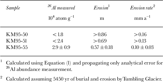
Samples collected from Crater Lake and its adjacent moraines have very low nuclide abundances indicating that any inheritance at this site is, at most, of minor importance (Table 1). Of the 18 analyses we made on nine samples, only seven are finite. The other 11 analyses indicate nuclide abundances low enough that we can only estimate upper limits. Because Baffin Island samples have low native Al (<140 μg g—1) and because our Al blanks are lower than our blanks for Be, Al is a more sensitive chronometer than Be. At this near-sea-level, high-latitude site, we have successfully measured 26Al model ages and set 26Al age limits < 1000 years (Table 2).
Table 2. Effective exposure age estimates for Crater Lake samples, Baffin Island.

Bedrock Samples
We collected four bedrock samples from two different roches moutonnees, outcrop 1 and outcrop 2 (OC1 and OC2, Table 2). All samples were striated and polished or grooved by ice flow. Three samples were collected from surfaces where striae indicate that at least some rock had been eroded by Tumbling Glacier (KM95-50, 51 and 55). The fourth sample (KM95-54) had grooves, the direction of which indicated that Tumbling Glacier had not removed any rock from the surface; rather, the KM95-54 surface was molded by ice flowing down Pangnirtung Pass, ice that numerous other cosmogenic ages indicate retreated about 7–8kyrBP (Reference Davis, Marsella, Bierman and CaffeeDavis and others, 1996b; Reference MarsellaMarsella, 1998).
The three bedrock samples that we collected from roches moutonnees, striated and polished by Tumbling Glacier and recently re-exposed, contain very low levels of 10Be and 26Al (Table 1, KM95-50, 51 and 55; Fig. 4). 26Al data suggest inheritance equivalent to <800yr (exposure age and age limits: <500, <600, 800 ± 300 yr; Table 2); we could not reliably detect 10Be in these samples (exposure age limits: <1800, <1600, <2300 yr; Table 2).

Fig. 4. View south to promontory of roches moutonnées across Crater Lake exposed by retreat of Tumbling Glacier. Sample sites are numbered according to data in Table 1. Note two geologists for scale about halfway down Little Ice Age moraine.
Only one bedrock sample from a roche moutonnée at Crater Lake (KM95-54; Figs 4 and 5) has striations and grooves recording ice flow from the large valley glacier occupying Pangnirtung Pass during the late Wisconsinan. This sample, KM95-54, is from the distal side of the same roche moutonnee as sample KM95-55. These earlier grooves and striations, which are nearly perpendicular to the direction of Tumbling Glacier flow, indicate that the Neoglacial ice that overrode outcrop 1 (OC1, Fig. 4) did not remove rock from the distal side; however, the proximal side of this roche moutonnée was eroded sufficiently to remove striations and polish from the Pangnirtung Pass glacier (KM95-55). KM95-54 is the only bedrock sample in which we measured finite abundances for both 10Be and 26Al. Both model ages are imprecise and concordant only at 2σ, (4000 ±1400 10Be yr and 1800 ± 500 26Al yr, weighted average 2050 ± 470 yr; Table 2). These values are far less than the late Wisconsinan age of the striae, indicating that the KM95-54 sample site, although not eroded by Tumbling Glacier, was covered with till or ice for much of the Holocene.

Fig 5. Roche moutonnée exposed by retreat of Tumbling Glacier, out of view to right. Ice-flow direction on Neoglacial surface (sample KM95-55) eroded by Tumbling Glacier indicated by black arrow; ice-flow direction on late Wisconsinan surface (sample KM95-54) eroded by Pangnirtung Pass glacier indicated by white arrow.
Taken together, the bedrock samples from the Crater Lake roches moutonnées suggest that during Neoglaciation at least a meter of bedrock was scoured from surfaces sloping toward Tumbling Glacier. However, the 10Be nuclide abundance for one bedrock surface sloping away from Tumbling Glacier (KM95-54) suggests late Wisconsinan erosion by the valley glacier in Pangnirtung Pass, followed by exposure during the middle part of the Holocene (i.e. about 7.5— 5.5 kyr BP), then burial during Neoglaciation. Burial was probably by Tumbling Glacier ice, and not till, as little till remains on the bedrock peninsula today.
Boulders and cobbles
We analyzed samples from three boulders, one near Crater Lake between the roches moutonnées (KM95-53; Fig. 4), the other two on a Crater Lake moraine (KM95-57, 58). The morainal boulders may have been exposed for several hundred to a thousand years; the Crater Lake boulder was deposited within the last two decades. We were unable to detect confidently 10Be in any of the boulder samples (exposure age limits: <3100, <2500, <3000 10 Beyr; Table 2). 26Al data better constrain the cosmic-ray exposure history of the boulders to the equivalent of < 1000 yr (exposure ages and age limit: 900 ± 400, 500 ± 300 and < 800 26Al yr; Table 2).
We collected and analyzed cobbles sitting on each of the roches moutonées (KM95-52 and 56, 0.25 and 0.11 m maximum diameter, respectively; Fig. 4). We were unable to detect either 10Be (< 1100 yr) or 26Al (<900 yr) in the larger cobble, implying that the cobble had no significant prior exposure history. The smaller cobble appears to have been exposed to the sea-level, surface equivalent of several thousand years of cosmic-ray bombardment; it has concordant and finite 10Be and 26Al exposure ages of 3000 ± 900 and 3200 ±1100 yr, respectively.
Discussion
We were not able to detect inherited nuclides in most samples collected from recently deglaciated (<20 yr) bedrock surfaces and from recently deposited (<200–1000 yr) morainal boulders near Crater Lake, Baffin Island. Bedrock surfaces, eroded by Tumbling Glacier and exposed within the last 20 years, have 26Al abundances the equivalent of, at most, 800 yr of surface exposure. Morainal boulders, deposited within the last millennium, have 26Al abundances equivalent to, at most, 900 yr of surface exposure. We could not confidently detect 10Be in any of these recently exposed boulder or bedrock samples.
These very low nuclide abundances support our assumption that concentrations of 10Be and 26Al, measured in samples collected from other Baffin Island roches moutonnées, probably reflect exposure ages unbiased by inheritance. Given the small size of Tumbling Glacier, samples that we collected from more than a dozen roches moutonnées along a 100 km transect from the crest of Pangnirtung Pass to the mouths of Pangnirtung and Kingnait Fiords (Fig. 1) probably inherited a low abundance of cosmogenic nuclides, considering the size of the late Wisconsinan valley glacier that eroded these features (Reference Davis, Marsella, Bierman and CaffeeDavis and others, 1996a, Reference Davis, Marsella, Bierman and Caffeeb). In this Arctic fiord environment, glacial erosion has apparently been sufficient to remove material significantly dosed by cosmic radiation during interglacials or interstadials. In the lower elevations of Pangnirtung Fiord, glacial erosion seems likely to have “reset” cosmogenic clocks to near zero by the time ice melted away exposing the outcrops.
The two cobbles we sampled have different exposure histories. In one cobble, we could detect neither 10Be nor 26Al, implying that, at most, the cobble has an effective exposure age <900yr. In the other cobble, we confidently detected both 10Be and 26Al; this cobble carries a significant inheritance (about 3000 yr) and, if collected to date a Holocene or late Pleistocene deposit, would result in an erroneous age assignment. We collected the cobble near sea level and have used sea-level nuclide production rates to estimate inheritance in terms of exposure duration. However, the cobbles and the boulders discussed above were likely transported from the accumulation zone of Tumbling Glacier, about 1000 m a.s.l., where production rates are higher by a factor ≥ 2.5. If this were the case, then the nuclide abundances we measured would reflect about 1000 yr of surface exposure at high elevation.
Sample KM95-54, the bedrock surface recently uncovered by retreat of Tumbling Glacier ice, but retaining its original down-valley ice-flow indicators, allows us to estimate crudely the total duration of Neoglacial ice cover. This sample-site surface was shaped by ice flowing down Pangnirtung Pass and Fiord, ice that numerous other cosmogenic ages indicate retreated from 7000–800010Be: 26Al yr ago (Reference Davis, Marsella, Bierman and CaffeeDavis and others, 1996a, Reference Davis, Marsella, Bierman and Caffeeb; Reference MarsellaMarsella, 1998). At some time(s), probably during the mid- to late Holocene, the sample site was overrun, but not eroded by ice of Tumbling Glacier. If we assume deglaciation by Pangnirtung Pass ice at 7500 ± 50010Be: 26Al yr and a weighted average 10Be: 26Al exposure of KM95-54 for 2050 ± 470 yr, then Neoglacial Tumbling Glacier ice expanded in Pangnirtung Pass and overran site KM95-54 for a total of about 5450 10Be: 26Al yr. Numerous other lines of evidence, described earlier, support Neoglaciation lasting 4000–5000 yr in the Pangnirtung Pass area (Reference DavisDavis, 1980, 1985, 1987).
Although Reference JahnsJahns (1943), Reference HalletHallet (1979, Reference Hallet1996) and Reference Sugden, Glasser and ClappertonSugden and others (1992) have contributed to our understanding of the glacial origin of stoss-and-lee topography, including roches moutonnées, the magnitude and rate of glacial erosion of stoss-and-lee bedrock forms have been difficult to quantify until recently. Reference Briner and SwansonBriner and Swanson (1998) used cosmogenic 36Cl in samples collected from a glacially eroded bedrock form in the Puget Lowland to calculate glacial erosion rates of the Cordilleran ice sheet during the last glaciation (about 3 calendar kyr of ice cover). They estimated glacial abrasion rates of 0.09–0.35 mm a 1 for the stoss side, 0.63–0.72 mm a—1 for summit surfaces and 0.13–0.28 mm a—1 for the lee side above the quarried zone.
Using data for samples KM95-50, 51 and 55, we can estimate a lower limit for the rate of glacial erosion by Tumbling Glacier at Crater Lake (Table 3). We calculate that samples KM95-50, 51 and 55 had 2050 ± 470 yr of early Holocene exposure (considering KM95-54 and other similar age estimates for the duration of Neoglaciation) before being covered and eroded by Tumbling Glacier for a total of about 5450 yr (7500 yr minus 2050 yr). Assuming production rates of Reference NishiizumiNishiizumi and others (1989), these three samples would have contained 12 300 ± 3000 atoms g—1 of 10Be and 74 000 ± 17 000 atoms g—1 of 26 Aljust before they were overwhelmed by the advancing Tumbling Glacier ice. Using the measured nuclide abundances and abundance upper limits, in conjunction with the depth-production rate model (Equation (1)), we can calculate lower limits for the rate of glacial erosion (Table 3).

x is the depth of rock eroded (cm), A the neutron absorption coefficient (165 g cm—2), ρ the rock density (2.7 g cm—3), N m the measured nuclide abundance or abundance limit (atoms g—1) and N0 is the pre-erosion nuclide abundance (atoms g—1).
Table 3. Erosion rates calculated for bedrock outcrops, Crater Lake, Baffin Island.

Because five of the six pertinent isotopic analyses only gave upper limits, we can calculate only one finite erosion rate. Based on 26Al abundance, Tumbling Glacier eroded rock from site KM95-55 at an average rate of 0.10 ± 0.03 mm a—1. Using upper limits of Al abundance for sample sites KM95- 50 and 51, we calculate that glacial erosion proceeded at average rates > 0.16 and > 0.13 mm a—1, respectively. Because we are less capable of detecting low levels of 10Be in our samples, the upper limits of 10Be concentration provide less-useful limits on glacial-erosion rates. However, conclusions reached from Be data are fully consistent with erosion rates calculated from 26Al measurements.
Our estimates of Neoglacial erosion rates of Tumbling Glacier are greater than those determined for 10 cirque glaciers in the Pangnirtung Fiord area by Reference AndersonAnderson (1978), who used estimates for volumes and ages of till in ice-cored moraines to calculate erosion rates of 0.008–0.076 mm a—1 . Our Neoglacial erosion rates are also greater than those determined by Marsella (unpublished data), who estimated volumes of silt accumulated in radiocarbon-dated sediment cores from a small lake down-valley from a cirque glacier near Pangnirtung Fiord (Reference Davis and AndrewsDavis and Kihl, 1985) to calculate erosion rates of 0.0016–0.040 mm a—1 . However, our estimates of Neoglacial abrasion rates are generally less than those determined by Reference Briner and SwansonBriner and Swanson (1998) for the Cordilleran ice sheet in the Puget Lowland.
Conclusions
Eighteen AMS analyses, made on samples collected from a landscape recently exposed by ice retreat, allow us to make four conclusions:
-
(1) Bedrock surfaces, striated and polished by Tumbling Glacier for several thousand years, contain very low levels of Be and Al, equivalent to 800 yr or less of surface exposure. This finding suggests that glacially molded bedrock surfaces in the Pangnirtung Pass and Fiord area are reasonable sites for sampling and cosmogenic dating, as inheritance of cosmogenic nuclides from prior exposure near Tumbling Glacier was minimal.
-
(2) Boulders sampled from the lateral moraine of Tumbling Glacier contain little 10Be or 26Al. Effective 26Al exposure ages are < 800 yr. Such low nuclide abundances imply that inheritance is unimportant for these boulders. One cobble, perched on a roche moutonnée, had the equivalent of several thousand years of surface exposure, suggesting that cobbles may be more likely than boulders to carry a significant inheritance of cosmogenic nuclides from prior exposure.
-
(3) Tumbling Glacier eroded competent, quartz-rich, gneissic bedrock at > 0.10 mm a—1 . This erosion rate is preliminary because only one sample was available for an estimate of ice-cover duration; however, this estimate is consistent with other evidence and the erosion-rate calculation is within the range of rates determined for the much-larger Cordilleran ice sheet in Washington State.
-
(4) Our data demonstrate that it is possible to measure finite 26Al ages near sea level and at high latitudes in samples as young as 500 yr. To achieve such low detection limits, purified quartz must contain low levels of 27Al. Detection limits of 10Be could be reduced by the use of lower- level carriers and larger sample sizes.
Acknowledgements
We thank P. Hackett, C. Killian, J. Leonard, C. Massey, J. Turner and staff of the Canadian Parks Service for field assistance; R. Finkel, Center for Accelerator Mass Spectrometry (LLNL), for laboratory assistance; and M. Kaplan, University of Colorado, D. Fabel, Purdue University, C. D. Clark, University of Sheffield and two anonymous reviewers for comments that improved the manuscript. The project was funded by U.S. National Science Foundation grant OPP-93-21733 to P.T. D. and P. R. B, with additional support from the American Association of Petroleum Geologists to K. A. M. Part of this work was supported under the auspices of the U.S. Department of Energy to LLNL under contract W-7405-ENG-48.