


Introduction
Over the last three decades, our understanding of the archaeological landscape of north-western Arabia has shifted significantly. Previously thought to be an area largely devoid of pre-Iron Age (c. twelfth to fifth centuries BC; see Sayce Reference Sayce1889: 406) activity, recent research has identified a vast prehistoric occupational landscape, characterised by a distinctly local cultural trajectory (see Crassard & Khalidi Reference Crassard, Khalidi, Boivin, Crassard and Petraglia2017; Guagnin et al. Reference Guagnin2020; Petraglia et al. Reference Petraglia, Groucutt, Guagnin, Breeze and Boivin2020). Thousands of stone structures have been identified across this region and the wider Arabian Peninsula. Collectively known as the ‘works of the old men’ (Maitland Reference Maitland1927; Rees Reference Rees1929; Kennedy Reference Kennedy2011), these structures date from the Middle Holocene (c. 6500–2800 BC) through to the present, with many hypothesised to be territorial markers (Steimer-Herbet Reference Steimer-Herbet2004; Bin ‘Aqil & McCorriston Reference Bin ‘Aqil and McCorriston2009; Magee Reference Magee2014). The structures range in form from burial cairns, tower and ‘pendant’ tombs (Braemer et al. Reference Braemer, Steimer-Herbet, Bucchet, Saliège and Guy2001; Guagnin et al. Reference Guagnin2020), to megalithic features (Zarins Reference Zarins1979; Gebel Reference Gebel2019; Munoz et al. Reference Munoz2020), to monumental animal traps (‘kites’; Kennedy et al. Reference Kennedy, Banks and Dalton2015) and open-air structures (‘gates’; Kennedy Reference Kennedy2017).
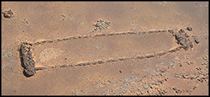
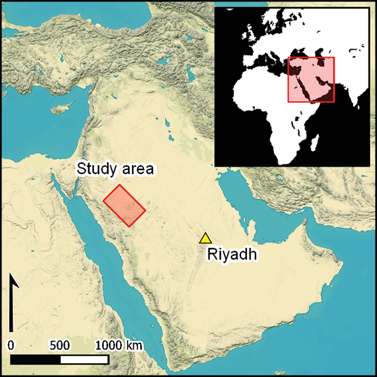
Of the aforementioned features, the ‘gates’ have received limited attention. Confined to north-western Arabia, these monumental structures were first recorded by surveys in the 1970s (Adams et al. Reference Adams, Parr, Ibrāhīm and Al-Mughannum1977: pl. 11; Parr et al. Reference Parr, Zarins, Ibrahim, Waechter, Garrard, Clarke, Bidmead and al-Badr1978: pl. 22b). It was only in 2017, however, that the first systematic study of this feature type was attempted (Kennedy Reference Kennedy2017). Typologically, these structures are marked by an approximately rectangular form, comprising two parallel short walls/platforms linked by two perpendicularly set, parallel long walls; some examples have central dividing wall(s) (Figure 1). Ranging from 20–620m in length, more than 1000 of these structures are currently known across approximately 200 000km2 of north-western Saudi Arabia (between latitude 22.989 and 28.064° and longitude 36.875° and 42.700°), with particular concentrations in AlUla and Khaybar Counties (Figure 2). The term ‘gate’ was coined due to their resemblance to traditional European fieldgates when viewed from above (Kennedy Reference Kennedy2017: 155). These features have recently been renamed by the Royal Commission for AlUla (RCU) as mustatils, due to their general shape—mustatil (مستطيل ) being the Arabic for ‘rectangle’—and to avoid nomenclatorial confusion (cf. Guagnin Reference Guagnin and Akkermans2020: 111; Groucutt et al. Reference Groucutt2020). The large size of many of these structures, combined with their frequency, suggests that they were an important component of the ancient Arabian cultural landscape.
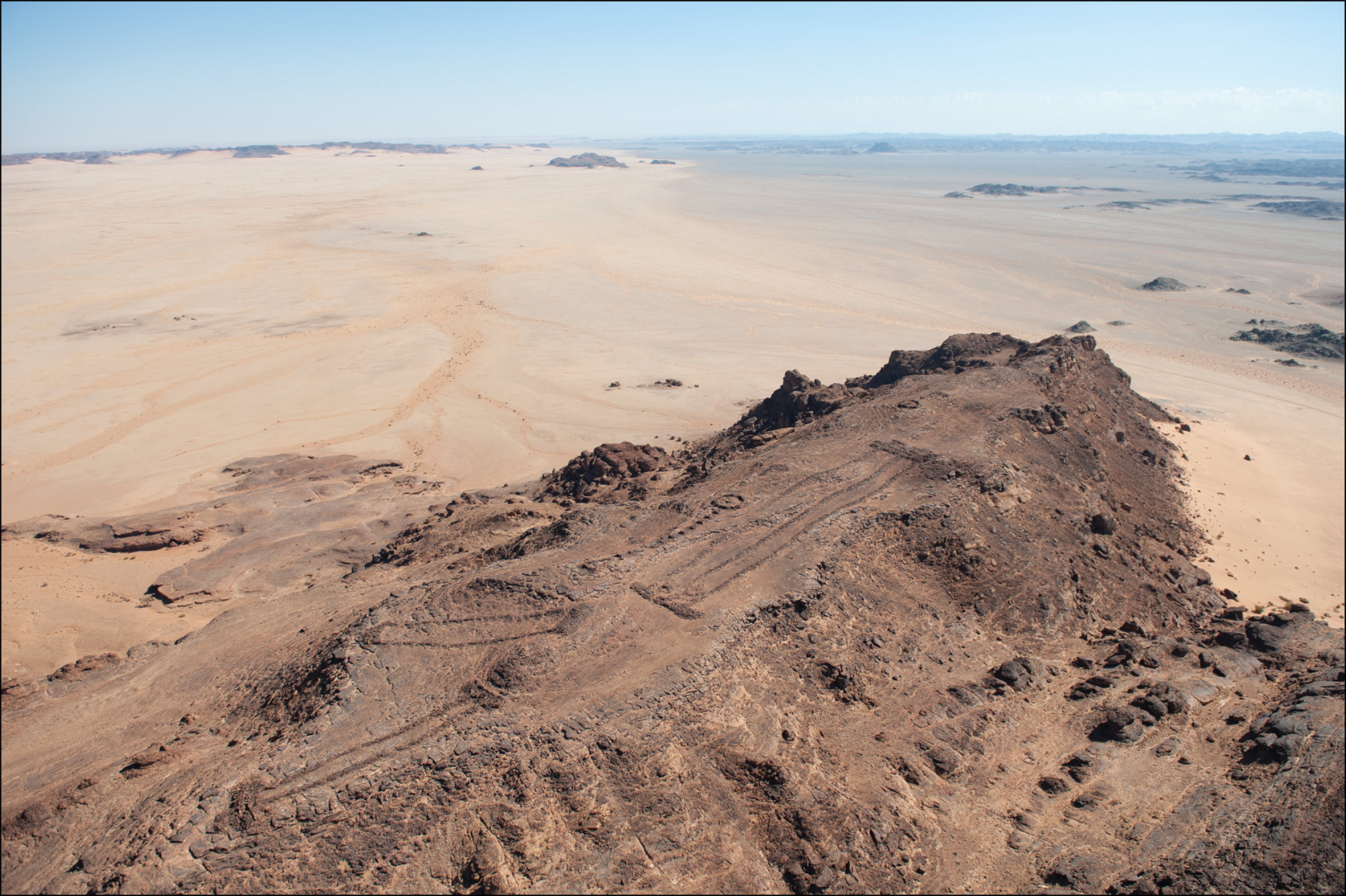
Figure 1. A group of three mustatils (photograph © AAKSAU and Royal Commission for AlUla).
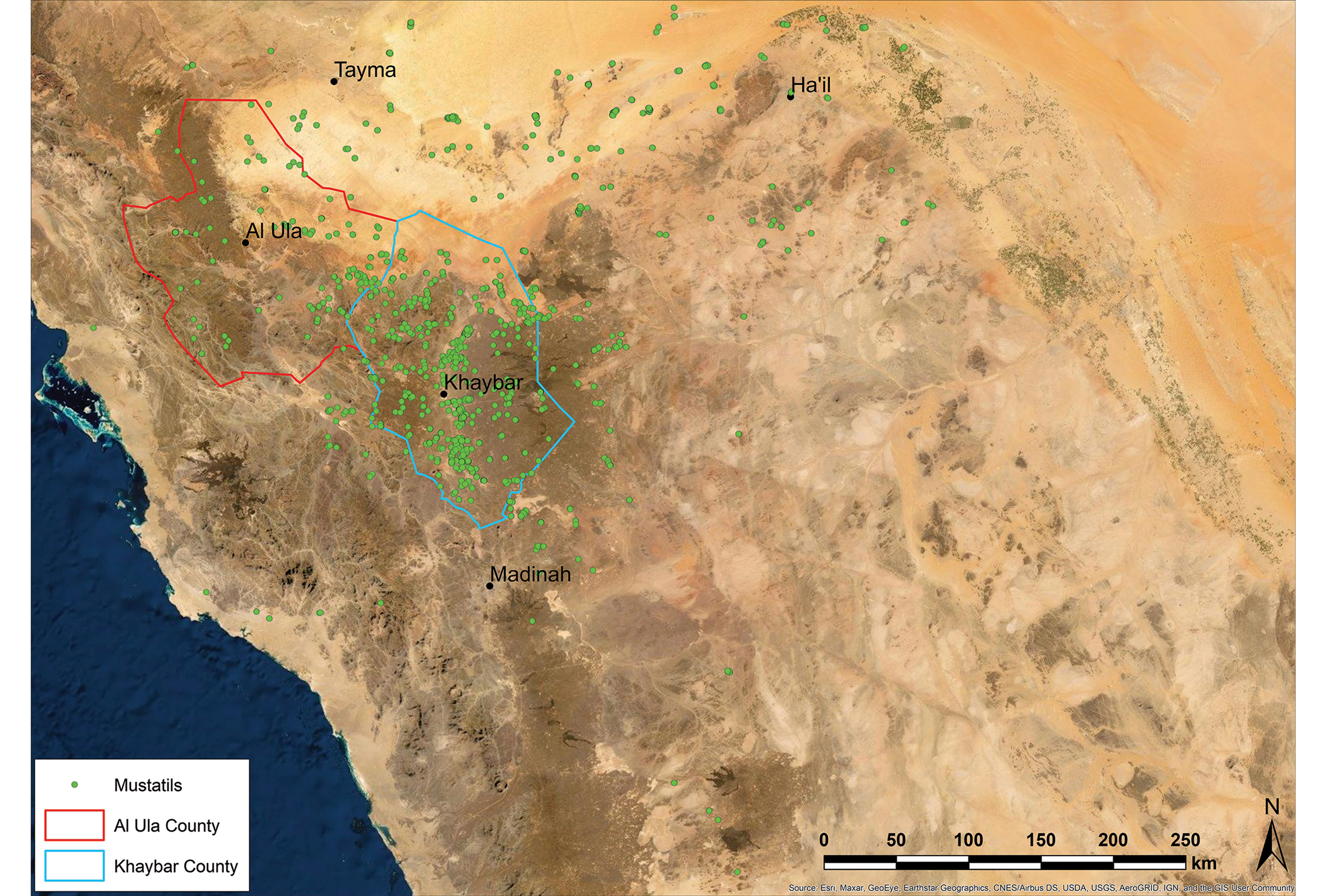
Figure 2. Mustatil distribution across north-western Arabia (© AAKSAU).
In 2018, the RCU commissioned the Aerial Archaeology in the Kingdom of Saudi Arabia AlUla (AAKSAU) project, a broad-ranging archaeological study of AlUla County, as part of the Identification and Documentation of the Immovable Heritage Assets of AlUla programme (IDIHA). A second project focusing on the Harrat Khaybar—Aerial Archaeology in the Kingdom of Saudi Arabia Khaybar—was established in 2019 after the RCU incorporated certain areas of Khaybar County under their remit. The project utilises publicly available satellite imagery (Google Earth/Bing Maps) to perform systematic remote-sensing surveys of AlUla and Khaybar, an area covering 40 000km2, followed by selective helicopter and ground surveys to photograph and investigate the identified structures. During four field seasons, over 350 mustatils have been photographed from the air, and a further 641 identified through remote-sensing (Table 1). Additionally, 39 mustatils have been ground-surveyed, with several recently excavated in AlUla, revealing, for the first time, a number of key features not visible through remote-sensing analysis. The distribution and morphology of these unique structures, and preliminary findings as to their function and date, can now be presented, placing these hitherto poorly understood features into their wider archaeological context. Recent excavations indicate that the mustatils functioned as monumental ritual structures, which can be preliminarily dated to the late sixth millennium BC. As such, north-western Arabia is marked by one of the world's earliest and largest monumental ritual landscapes.
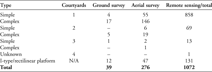
Table 1. Total known number of mustatil types and I-type/rectilinear platforms surveyed by methodology, excluding features identified from satellite imagery only.
Geological contexts of mustatils
Consideration of the complex geology that characterises mustatil distribution in Arabia is important to our understanding of the structures. The geology of north-western Arabia comprises three main bedrock types: Lower Palaeozoic (Cambro-Ordovician) sandstones, Cenozoic basalts and predominantly volcanic-sedimentary sequences associated with the Precambrian Arabian Shield (Coleman et al. Reference Coleman, Gregory and Brown1983).
The geomorphological landscape is a function of the age, lithology and hardness of the local bedrock, as well as its structural attitude and the degree and nature of bedrock weathering. The structural attitude of the bedrock has a major impact on the landscape and, subsequently the archaeology. The younger sequences (Cambro-Ordovician sandstones and harrat basalts) are generally flat-lying, whereas the older Arabian Shield rocks include sequences that are steeply inclined.
The relatively homogeneous Cambro-Ordovician sandstones have been weathered to form the largest individual landforms. Water erosion has created a deeply incised landscape of canyons and mesas, whose exposed upper elevations have been sculpted by wind abrasion to form yardangs. The relief of the desert landscape becomes progressively more subdued as a result of intense wind erosion, and the terrain is dominated by groups of monolithic yardangs and mega-yardangs with wind-smoothed edges. The mesa-like hilltops of these yardangs are often blackened by a patina of desert varnish.
Harrat basalts (lava fields) form sizeable landscapes, the largest being the coalesced lava fields of the Harrats Khaybar, Kura and Ithnayn (Camp et al. Reference Camp, Roobol and Hooper1991: 364) and the Harrat Uwayrid basalt plateau north-west of AlUla. These lava fields range in date from Miocene to recent and exhibit a range of landscape sub-types. The older, more weathered Miocene lava fields have flat or gently undulating flow surfaces with few clay pans (qa’). In contrast, the Pliocene and Early Holocene lava fields associated with Harrat Khaybar are notable for their hummocky, ‘whale-back-style’ terrains, large clay-filled depressions and localised higher relief around volcanic vents. Mustatils are found on all of these lithologies, varying by structure placement, form and construction methods (Table 2).
Table 2. Number of known mustatils and I-type/rectilinear platforms built on main bedrock lithologies and locational characteristics.
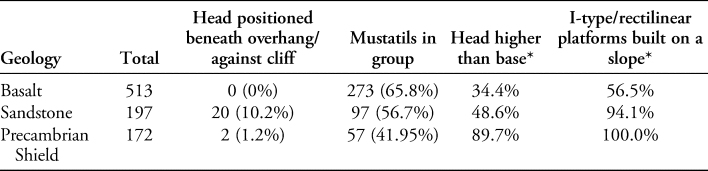
* Calculated from ground-surveyed and aerial-photographed examples only.
Description
Mustatils are characterised by a number of key components: a head, courtyard, long walls, a base and, in some instances, a series of associated features including circular cells and orthostats (Figures 3–4).
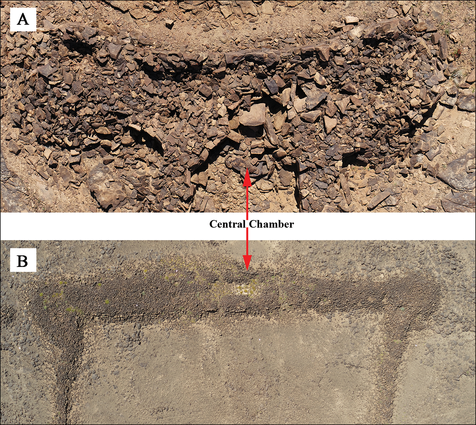
Figure 3. The head of a mustatil, note the chamber in the centre of the platform (photographs © AAKSAU and Royal Commission for AlUla).
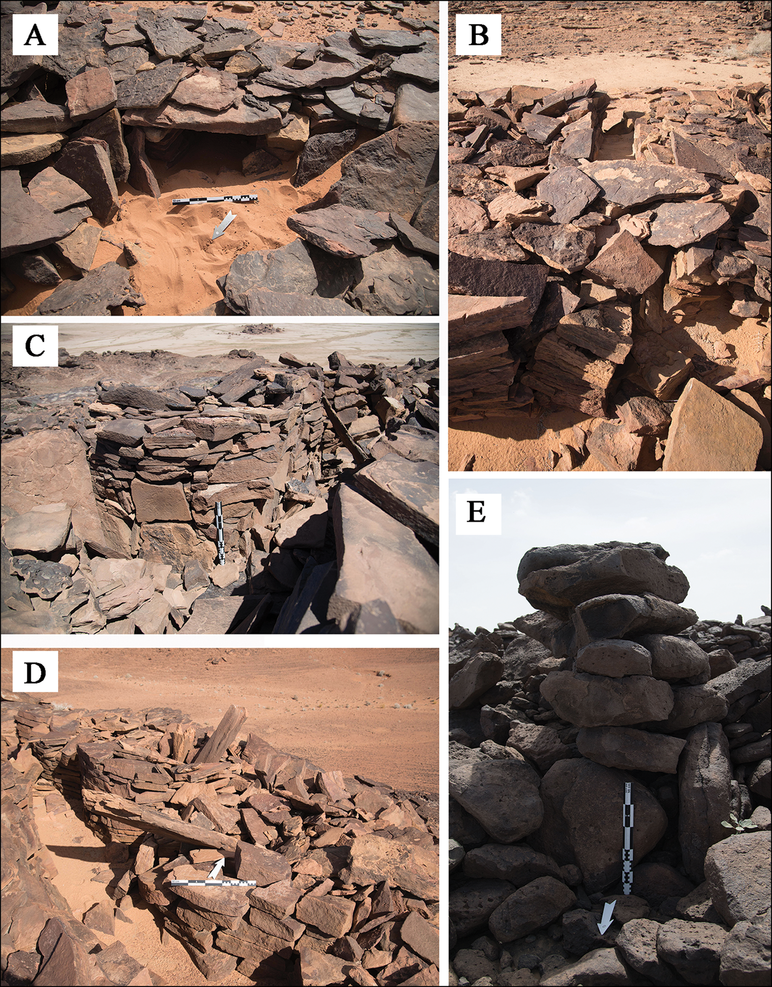
Figure 4. Features of mustatil: A) internal niche located in the head of a mustatil; B) a blocked entranceway in the base of a mustatil; C–D) associated features of a mustatil: cells and orthostats; E) stone pillar identified on the Harrat Khaybar lava field (photographs © AAKSAU and Royal Commission for AlUla).
The head of the mustatil is generally characterised by a sub-rectangular to rectangular rubble platform of dry-stone masonry. Where sandstone is available, flat unworked slabs were laid in courses, or, alternatively, unworked boulders of local stone were stacked and fitted together. The head generally ranges from 10–50m in length and 0.3–1.2m in height (Figure 3A–B), and several morphological distinctions are apparent within this feature form. In most instances, a single rectangular or ovoid chamber can be identified in its centre. These chambers range in size from 2.8 × 2.8m to 10 × 3m. Several examples are characterised by doorways (<0.5m) that connect the chamber to the courtyard. In some instances these doorways have been deliberately blocked, possibly indicating decommissioning (Figure 4B). Several chambers appear to have been sealed by either a single, monumental capstone or a collection of stones. A lack of such a capping on other examples suggests that some chambers were open-air. Other architectural features, such as niches, have also been identified within the central chamber. The best example of this is at IDIHA-F-0003301, which exhibits at least one well-constructed internal niche (Figure 4A). This niche is 0.3m deep, inward facing and not visible from the exterior of the structure.
Mustatils have an open, elongated courtyard, bounded by the head, base and long walls. These appear to have been empty, although later enclosures and funerary structures were occasionally built within this area. In other instances, outcropping bedrock is visible, limiting the possibility of significant depositional sequences.
The method of long-wall construction varies, with two rows of either horizontally or vertically laid stone, with a rubble core. Often, a mixture of both horizontally and vertically laid stone was used in a single structure. These walls range in width from 0.5–3m, and in height from 0.3–1.2m—in most instances the walls are preserved to their original height.
The key feature of the rubble platform base is a narrow entranceway. Entranceways have been identified in most mustatils. These entranceways are positioned in the centre of the base platform, directly opposite the central chamber in the head (Figure 5), and usually range in width from 0.3–0.8m, with rare examples up to 1m. Furthermore, many of the ground-surveyed examples yielded evidence to suggest that some entranceways were blocked and decommissioned (n = 14; Figures 4B & 5). In some cases, this appears to have been symbolic, with a few stones blocking either end (Figure 5A & C), while in others the entire entranceway is infilled (Figure 5B).
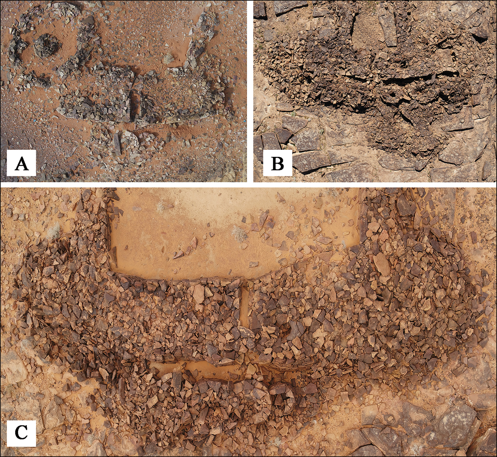
Figure 5. Aerial image of three mustatil bases. Note the associated features (cells and orthostats) and blocked entranceways (photographs © AAKSAU and Royal Commission for AlUla).
Associated features
The area immediately in front of the base of many mustatils is marked by a series of associated features. Sixty-five of the 109 examples (56.6 per cent) photographed from the air or ground-surveyed in AlUla exhibit discrete or interlocking circular cells ranging in number from three to eight, with an average of six (Figures 4C–D & 5). The true number of such cells may be higher, as many are obscured by deposits of wind-blown sand. Discrete cells are generally identical in size, with diameters ranging from 1–2m. While interlocking examples vary in size, the outer cells are generally smaller (1–1.3m), and central cells progressively larger (1.8–2m). As these cells are positioned parallel to the base of the mustatil, a small passageway is formed between the outer edge of the base and the cells, through which the entranceway and courtyard of the mustatil are accessed. In five of the ground-surveyed examples these passageways are blocked, either deliberately or by collapse. Furthermore, in seven of those surveyed, these cells contained one to two orthostats (Figure 4C–D). Often positioned upright in the centre of the cell, a number of these slabs are still in situ. These orthostats are fashioned from local stone and range in size from 1–1.5m in height. No decoration is discernible.
Ground-surveyed mustatils built on the Harrat Khaybar lava field display different associated features. Here, orthostats are notably absent, probably due to the paucity of suitably long stones in the underlying basalt geology. Instead, boulders were stacked to create free-standing pillars (Figure 4E). We observed clusters of pillars, with up to 50 associated with one mustatil. Although many have toppled, some pillars remain in situ.
Related structures
Kennedy (Reference Kennedy2017: 162) notes distinctive ‘I-type’ structures found in association with many mustatils; these are named after their resemblance to a serifed ‘I’ (Figure 6). Aerial photography and ground-survey have revealed that these structures comprise low, rubble-filled platforms with an exterior face. Known examples constitute a continuous spectrum of forms, ranging from markedly ‘I-shaped’ (Figure 6A–B) to precisely rectangular with no protrusions (‘rectilinear platforms’; Figure 6C–D). These I-type and rectilinear platforms clearly mirror the morphological variations displayed by mustatils, and are located across the same general geographic range, albeit in lower numbers (Table 1). Far smaller rectilinear platforms have also been identified in southern Jordan (Abu-Azizeh et al. Reference Abu-Azizeh, Tarawneh, Abudanah, Twaissi and Al-Slameen2014: 171–72), but the relationship between these structures and those from north-western Arabia has yet to be investigated.

Figure 6. A–B) I-type platforms; C–D) rectilinear platforms (photographs © AAKSAU and Royal Commission for AlUla).
Of the 131 known examples of these platforms recorded by the AAKSAU project, 73 (55.7 per cent) are positioned adjacent to a larger mustatil. These are usually oriented parallel to the mustatil and situated next to its base or, more rarely, to the exterior of a mustatil long wall. Ground-surveyed examples in AlUla were all associated with a mustatil, with these I-type platforms ranging in number from one to six per mustatil, and from 16 × 7m to 42 × 16m in size. When associated with mustatils, these features do not overlie or repurpose stone from the larger feature. Alongside their analogous shape, this suggests that I-type/rectilinear platforms and mustatils were contemporaneous and, when situated together, were probably functionally related.
Typology
While the mustatils surveyed to date demonstrate significant variations in size, form and complexity, broadly consistent characteristics can be defined. Although Kennedy (Reference Kennedy2017: 161) proposed two types of mustatil based on the length of the short walls (head and base) in relation to the long walls, recent ground and aerial surveys allow for a revised typology (Figure 7).
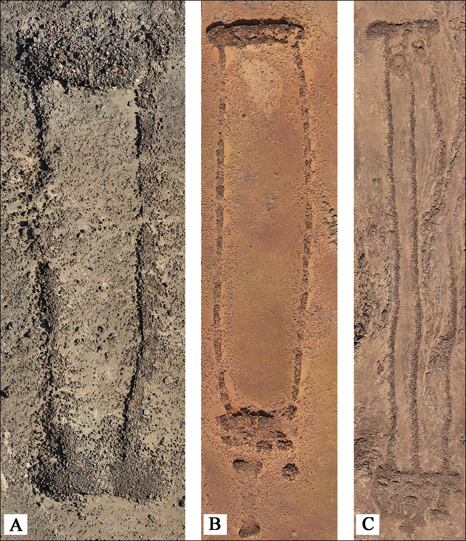
Figure 7. A) ‘Simple’ mustatil; B–C) ‘complex’ mustatils, single (B) and double (C) (photographs © AAKSAU and Royal Commission for AlUla).
‘Simple’ types comprise a rectangular or sub-rectangular structure, characterised by the following components: a head, base, long walls and a courtyard. These structures can be with or without entranceways in the base, but are predominantly without (Figure 7A). ‘Complex’ types also comprise a rectangular or sub-rectangular form with a head, base, long walls and a courtyard. Key features include an entranceway in the base, as well as associated features, specifically circular cells and orthostats/pillars (Figure 7B–C). I-type platforms are only found in association with this variant.
Variations in both simple and complex mustatil types exist. In both types, the courtyard is rarely marked by one or more central dividing walls, creating up to four distinct parallel courtyards running from base to head (Figure 7C). The majority of ground-surveyed examples were built during a single constructional episode, although some were later modified. Corresponding central chambers are often present in the head (Table 1). Each courtyard is generally accessed by its own entranceway through the base. Multiple courtyard forms appear to be distributed randomly across north-western Arabia, with no clear concentrations.
Location and orientation
Mustatils were built upon all primary bedrock lithologies within their ranges (Table 2) and in a variety of topographic positions (Figure 8). The structures exhibit neither preferential orientation towards cardinal points, nor to prominent local landforms. Instead, they are usually oriented according to local topography, which varies significantly depending on available landforms and bedrock geology. Where built on hillsides, mustatils were invariably oriented perpendicular to the slope (Figure 8B). Meanwhile, those constructed upon narrow sandstone mesas or ridgelines were usually oriented to take advantage of the longest available edge. There is no discernible reasoning underlying the seemingly random orientations of mustatils built on flat ground, as in much of the Harrat Khaybar lava field.
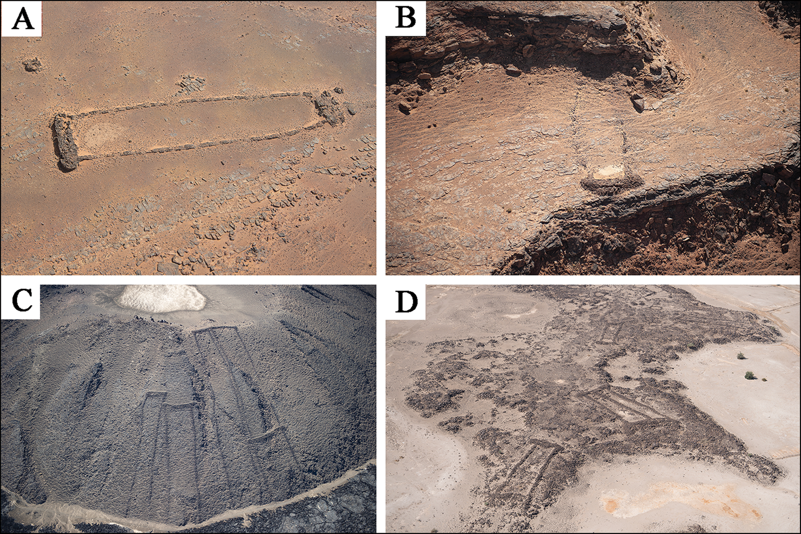
Figure 8. Geographic positioning of different mustatils (© AAKSAU and Royal Commission for AlUla).
Notably, mustatil heads were often placed higher than any other part of the structure, especially in examples built over the rugged Precambrian Arabian Shield (Table 2). This tendency is less marked in sandstone landscapes, due to the construction of many of the mustatils on isolated, relatively flat mesas, or on plateaux (Figure 8A). Topography suited to this arrangement is rare in Harrat Khaybar, with the exception of prominent volcanic vents, against which several mustatils were built (Figure 8C). This strongly suggests that the prominence of the head was important. Likewise, the majority of I-type and rectilinear platforms were also built upon slopes (Table 2). Mustatils and platforms built upon hillslopes are often visible from great distances, suggesting that prominence within the landscape was a desirable characteristic. Others, particularly those situated atop isolated sandstone mesas, are far less visible from surrounding lowlands, but command extensive views from the features themselves (Figure 1). This strongly suggests that enhanced visibility of and/or from mustatils was a significant factor in their placement, where local topography allowed.
Mustatils are frequently clustered together in groups of between two and 19 (groups defined here as mustatils within 500m of each other), excluding associated platforms. While mustatils within the Harrat Khaybar display the greatest tendency towards grouping, the practice was common across their distribution (Figure 8D & Table 2). Understanding the significance of this grouping requires better chronological refinement of their construction and use.
Finally, a few mustatils were constructed with their heads positioned beneath rock overhangs (Figure 8B). Such examples are located only on sandstone, where such overhanging landforms are common, although two examples were built on Precambrian Arabian Shield rock, with their heads abutting cliff faces, thus achieving a similar effect.
Dating and function
In late 2019 the AAKSAU project began excavating an undisturbed mustatil (IDIHA-F-0011081) east of AlUla. Excavations within the central chamber of the head revealed a series of stratigraphically distinct, in situ faunal remains: specifically, horns and cranial elements. A variety of domestic and wild taxa were identified, including cattle (Bos sp.), sheep/goat (Ovis sp. and Capra sp.) and gazelle (Gazella sp.), with cattle comprising the bulk of the assemblage. These remains can be interpreted as ‘offerings’, as they were deposited around a large upright stone (betyl) positioned in the centre of the chamber (Figure 9A–C). No human remains or evidence for domestic occupation were identified during the excavation. Radiocarbon-dating of a cattle horn (bioapatite, UGAMS#46488) and tooth (collagen, S-ANU#64603) revealed a Late Neolithic, sixth-millennium BC date (Figure 10; dates calibrated using OxCal v4.4.1 and the IntCal20 calibration curve (Bronk Ramsey Reference Bronk Ramsey2020; Reimer et al. Reference Reimer2020).
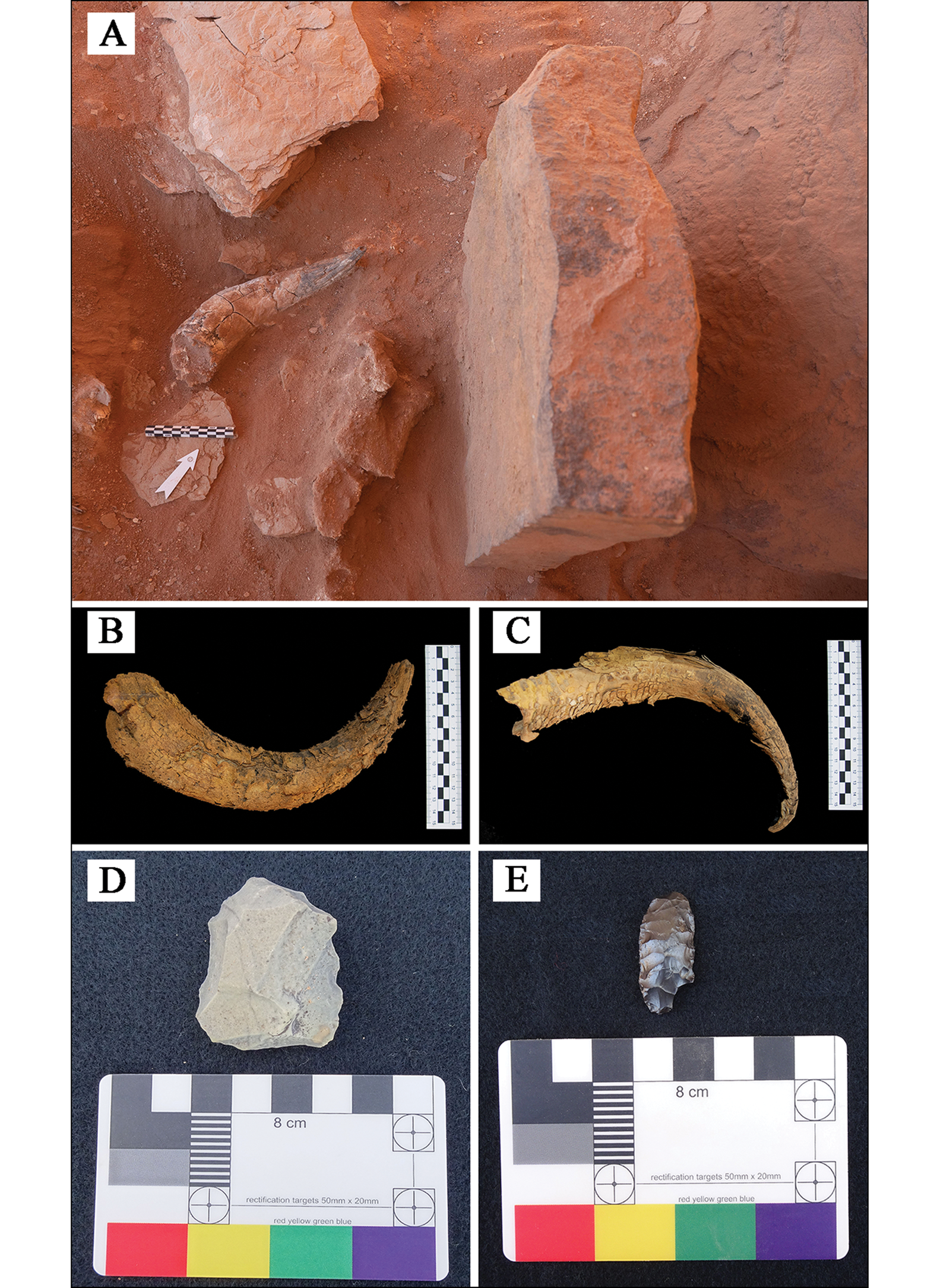
Figure 9. Artefacts recovered during excavation and ground survey: A) cattle horn positioned in front of a betyl at IDIHA-F-0011081; B–C) cattle horns recovered from IDIHA-F-0011081; D) Neolithic micro core collected from IDIHA-F-0003301; E) Neolithic bifacial foliate identified at IDIHA-F-0011394 (photographs © AAKSAU and Royal Commission for AlUla).
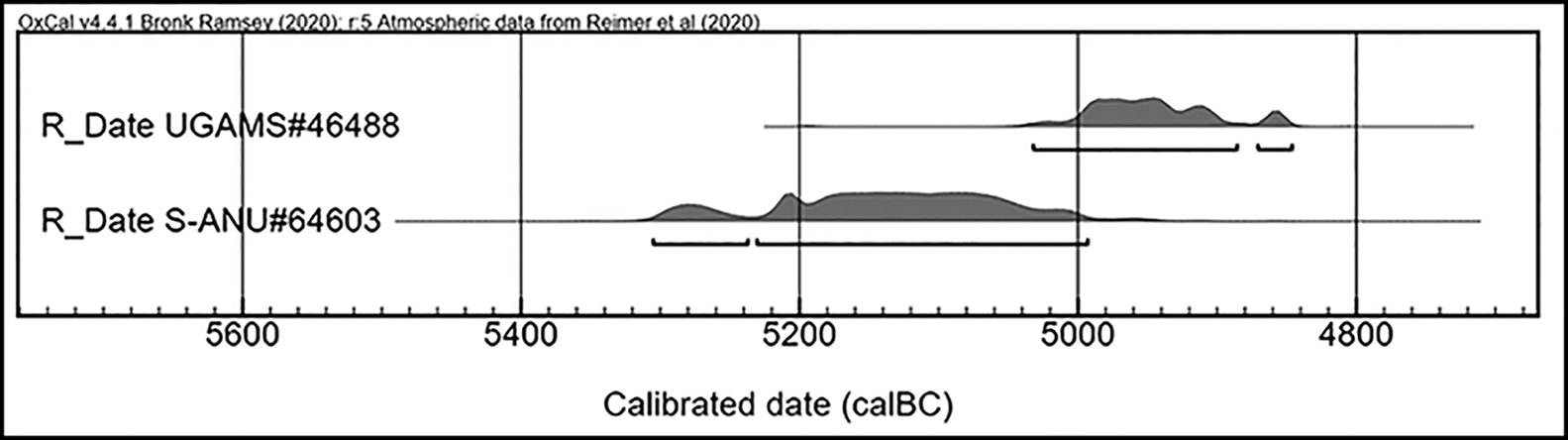
Figure 10. Radiocarbon assays from IDIHA-F-0011081 (calibrated using OxCal v4.4.1 and the IntCal20 calibration curve; Bronk Ramsey Reference Bronk Ramsey2020; Reimer et al. Reference Reimer2020) (© AAKSAU and Royal Commission for AlUla).
A ritual function can be hypothesised for the mustatils based on the type and positioning of these faunal remains—an assertion strengthened by previous excavations at other mustatils in AlUla, which have revealed similar dates and assemblages (W. Abu-Azizeh pers. comm.). Similarly, charcoal recovered from a looted mustatil, located south of the Nefud Desert, has also produced a late sixth- to early fifth-millennium BC date, along with similar faunal remains (Groucutt et al. Reference Groucutt2020). A ritual function for these structures is also suggested by their size and prominence in the landscape, as well as the low height of the long walls (0.3–0.5m) and narrow entranceways, which suggest that mustatils could not have functioned as animal pens. Moreover, none of the components of these features can plausibly be interpreted as the remains of permanent or seasonal occupation. Nor is there evidence to suggest that these structures were ever roofed.
The architecture of these mustatils suggests that their use involved an element of procession. Their narrow entranceways indicate that the structures were accessed in single file, with individuals then proceeding towards the structure's head, a scenario probably indicative of ritual use. The addition of orthostats further suggests such a function, as orthostats/pillars have been found in other early Arabian ritual contexts (Zarins Reference Zarins1979; Gebel Reference Gebel2019).
Ground survey has identified small numbers of artefacts at four of the 39 mustatils visited, comprising exclusively chipped stone. A flaked micro core from IDIHA-F-0003301 (Figure 9D) and an obsidian bifacial foliate from the courtyard of IDIHA-F-0011394 (Figure 9E) find their closest parallels in Neolithic northern and north-western Arabia (Gilmore et al. Reference Gilmore, Al-Ibrahim and Murad1982: pl. 30: 2–21; Groucutt & Petraglia Reference Groucutt and Petraglia2012: fig. 8: 6; Crassard et al. Reference Crassard2013: fig. 11). Non-diagnostic flakes and debitage were recovered from the courtyard of IDIHA-F-011392. Finally, the courtyard of IDIHA-F-0011361 was littered with chipped-stone artefacts, none of which could be assigned a definitive date. With these exceptions, surveyed courtyards were otherwise devoid of cultural material.
Mustatils are frequently found in direct stratigraphic association with one or more other structures not of the associated forms discussed above, such as funerary monuments and ‘kites’. The 118 examples of such relationships recorded in aerial photographs show that, for the most part, mustatils were overbuilt (or were structurally robbed), making the mustatil structures sequentially earlier. In rare cases, one mustatil overlies another, further suggesting that they are amongst the earliest stone-built monuments in north-western Arabia.
At present, there is no evidence for contemporaneous human burials in or around mustatils, although further excavation is required across north-western Arabia to confirm this. Mustatils certainly became a focus for later funerary activity, however, being frequently superimposed by ringed tombs with (n = 30) and without ‘pendant’ tails (n = 13; Figure 5). Based on grave goods, Parr et al. (Reference Parr, Zarins, Ibrahim, Waechter, Garrard, Clarke, Bidmead and al-Badr1978: 40) date these ‘pendant’ tombs in north-western Arabia to the fourth to third millennia BC, suggesting that the mustatils pre-date these monuments in this region. In southern Arabia and the Levant, similar tombs have been dated to between the fourth millennium BC and the third century AD (McCorriston et al. Reference McCorriston, Steimer-Herbet, Harrower, Williams, Saliège and Bin ‘Aqil2011: tab. 1; Akkermans et al. Reference Akkermans, Brüning, Arntz, Inskip and Akkermans2020: figs 7–8). This apparent appropriation of pre-existing monuments by later communities was perhaps undertaken for reasons of territoriality or identity building (Magee Reference Magee2014: 83–86).
Of particular interest are five known examples in which mustatils were overbuilt by ‘kites’ (Kennedy Reference Kennedy2017: fig. 30)—although Parr et al. (Reference Parr, Zarins, Ibrahim, Waechter, Garrard, Clarke, Bidmead and al-Badr1978: pl. 22b) identified a mustatil potentially superimposed over a kite. Kites are generally dated to the Neolithic–Chalcolithic in the Levant (Helms & Betts Reference Helms and Betts1987: 47; Échallier & Braemer Reference Échallier and Braemer1995: 55; Al-Khasawneh et al. Reference Al-Khasawneh, Murray, Thomsen, Abu-Azizeh and Tarawneh2019: 2118), with some possible exceptions dating to the fourth to third millennia BC (Zeder et al. Reference Zeder, Bar-Oz, Rufolo and Hole2013: 117). Although further chronological refinement of kites in Saudi Arabia is required, a Neolithic date for some of these features is compatible with the available regional data.
Geology and construction
Mustatils were constructed of readily available local stone, influencing construction methods, appearance and durability. Sandstone cleaves naturally along bedding planes and laminae, and when these natural weaknesses are exposed to weathering, the rock becomes fissile and will split, forming a flagstone surface. Schistosity in metamorphic rocks, such as are found in parts of the Precambrian Arabian Shield, produces a similar effect. Weathered, fissile rock can be extracted in sheets either by hand or with the help of wooden levers. Larger flagstones can be used as orthostats, or placed end-on in the ground to form a vertical wall. There are many examples of such sheets, weighing in excess of 500kg, being used in this way. Sheets could also be broken into smaller pieces for regular wall construction. Well-made walls faced with sandstone flagstones can be tightly fitted, and are less likely to collapse than walls made from more rounded, freestone fragments, such as those typical in basalt terrains. This is one significant factor in the varied levels of preservation found across surveyed mustatils.
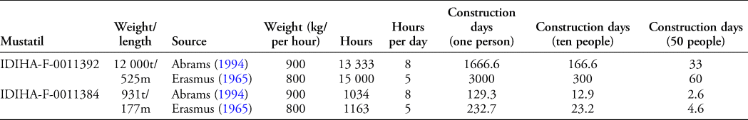
The largest mustatil that we ground-surveyed (IDIHA-F-011392) is located on the Harrat Khaybar lava field, 50km south of Khaybar town. Built from basalt boulders, it measures 525m in length. The structural weight of this feature is approximately 12 000 tonnes, utilising a figure of 2500kg/m3 for the density of basalt lava (Downs et al. Reference Downs, Stelten, Champion, Dietterich, Nawab, Zahran, Hassan and Shawali2018: 1262) and allowing for 20 per cent of its volume being voids. Individual construction stones weigh from 6–500kg.
Hypotheses regarding the outlay of time and labour for mustatil construction can be proposed by extrapolating data from several experimental studies of Mayan labour investment. Abrams's (Reference Abrams1994: 46–47) experiments, for example, suggest that one person could carry 7200kg of cobbles over an eight-hour day. Meanwhile, Erasmus's (Reference Erasmus1965: 284–93) study estimated that, in moving stones just 50m from their source, an individual could relocate approximately 4000kg of stone in a five-hour workday. As mustatils were constructed from locally available stone, it is possible to provide a rough estimate of construction time, although these calculations do not consider variables such as weather and food provision. Table 3 indicates that a group of 10 people could construct a mustatil in excess of 150m in length over a two- to three-week period. Similarly, larger structures up to 500m in length could have been constructed by a group of 50 people in as little as two months. Based on these estimates, it would appear that small groups could have built most of the mustatils in a relatively short period of time. For larger structures, a few hundred metres in length, construction would have taken a family group several months, but if multiple families or wider groups worked together, this task could have been achieved in a shorter timeframe. Any such gathering of wider community groups to build mustatils would fit well into the broader, regional Neolithic/Chalcolithic phenomenon in which ritual structures functioned as symbolic demonstrations of collective power and legitimacy (Banning Reference Banning2011: 623; Rosen Reference Rosen and Laneri2015: 44–46), and as a mechanism for maintaining social cohesion amongst dispersed nomadic/pastoralist communities (Magee Reference Magee2014: 81).
Table 3. An analysis of IDIHA-F-0011392 and IDIHA-F-0011384 in relation to the studies of Abrams (Reference Abrams1994) and Erasmus (Reference Erasmus1965).
Mustatils and the Middle Holocene of the Arabian Peninsula
Situating mustatils within their wider chrono-cultural context is key to understanding these structures. If an exclusively Late Neolithic date is proposed, how and where do these monumental structures fit into our understanding of the development of the Arabian Neolithic? At present, the ‘Neolithisation’ of the Arabian Peninsula remains the subject of scholarly debate (Drechsler Reference Drechsler2009; Crassard et al. Reference Crassard2013; Crassard & Drechsler Reference Crassard and Drechsler2013; Magee Reference Magee2014: 49–61). It appears likely that regionally specific fluctuations in climate throughout the Late Pleistocene and Early Holocene facilitated repeated dispersals of people and technologies into the region, which, tempered by a strong local component, resulted in the development of Arabia's distinct and regionalised material cultures (Groucutt & Petraglia Reference Groucutt and Petraglia2012: 123; Crassard & Khalidi Reference Crassard, Khalidi, Boivin, Crassard and Petraglia2017: 229–30). The relationship between the mustatils and the Holocene Humid Phase (c. 8000–4000 BC), however, remains unknown (Petraglia et al. Reference Petraglia, Groucutt, Guagnin, Breeze and Boivin2020) and forms a key avenue for future research.
The apparent ritual deposition of animal horns and cranial elements, particularly of cattle at IDIHA-F-0011081, offers the first evidence for the possible existence of a Neolithic cattle cult in north-western Arabia. Cattle were a vital commodity for the early pastoral inhabitants of Arabia (McCorriston et al. Reference McCorriston, Harrower, Martin and Oches2012). The importance of this relationship is highlighted in the rock art of the region, with scenes of both cattle herding and hunting frequently appearing (Guagnin et al. Reference Guagnin, Jennings, Clark-Balzan, Groucutt, Parton and Petraglia2015). The identification of cattle cults in north-western Arabia would pre-date the earliest known examples of this phenomenon in the southern Arabian Peninsula by 900 years (Shi'b Kheshiya in Yemen, c. 4400 BC). The Kheshiya structures have been associated with territoriality, feasting and the control of pastoral resources (McCorriston et al. Reference McCorriston, Harrower, Martin and Oches2012: 57). The large size of mustatils, and their construction to a consistent plan with comparatively little typological variation across wide geographic areas, may suggest that they also functioned as territorial markers, potentially denoting ancestral pasturage or some other form of connection with the landscape. Indeed, roughly contemporaneous monumental structures, interpreted as territorial markers, have been identified in north-western Arabia at Dûmat al-Jandal (Munoz et al. Reference Munoz2020: 613). In other areas of the Peninsula, the construction of monumental burial structures also probably served this role (Braemer et al. Reference Braemer, Steimer-Herbet, Bucchet, Saliège and Guy2001; Steimer-Herbet Reference Steimer-Herbet2004). Although temporally and geographically dispersed, these varied monument types were clearly intended to mark the landscape visibly, albeit as regionally distinct and culturally specific manifestations of territoriality.
Although no direct typological parallels for the mustatils have been identified anywhere else, investigations in the Negev Desert have revealed a number of large, rectangular, ‘open-air sanctuaries’ (Avner Reference Avner1984), almost all of which date to the sixth millennium BC (Rosen Reference Rosen and Laneri2015: 40). Basic elements, such as orientation and artefact assemblages, show no clear correlation with the mustatils investigated by our team, although both structure types are similar in form. Furthermore, both show a notable absence of evidence for domestic occupation. Although defining the relationship or distinction, if any, between ‘sacred’ and ‘profane’ in the Neolithic of the Near East has been the subject of intense debate (Kuijt Reference Kuijt2005; Banning Reference Banning2011), it appears that the mustatil tradition may represent an early example of such a delineation, facilitating preliminary inferences regarding the development of cult ideology in Neolithic north-western Arabia.
Mustatils represent one of the most architecturally homogeneous building traditions identified to date in the Arabian Peninsula, probably adapted for the availability of local resources, as well as functional or demographic needs. The further contextualisation of these important structures requires a fuller understanding of Middle Holocene settlement dynamics and human-animal interactions in north-western Arabia; these are topics of ongoing investigation. The concentration of mustatils, however, suggests that north-western Arabia may have been densely occupied during the Middle Holocene. The scale and form of these structures make them unique to the region, highlighting the robust local component of the Arabian Neolithic. As such, mustatils may become key in articulating the regional and inter-regional relationships present in Arabia during the Middle Holocene, and one of the earliest, large-scale monumental building traditions known to date.
Acknowledgements
We wish to thank the Royal Commission for AlUla for its support. We extend special thanks to the Governor, His Highness Prince Badr bin Abdullah bin Mohammad bin Farhan Al Saud; CEO, Amr AlMadani; and the Director of Archaeology and Cultural Heritage Research, Rebecca Foote. We would like to acknowledge the assistance of Laura Strolin, Jamie Quartermaine, Wael Abu-Azizeh and Huw Groucutt. Finally, we thank David Kennedy, who first introduced us to mustatils and whose exemplary work is the reason this project exists.
Funding statement
Funding is provided by the Royal Commission for AlUla.


 Open access