The project and site 35
Since 2015, the ‘Karaburun Archaeological Survey’ project (KASP) has been generating data on the early prehistory of western Anatolia. A complete lack of information concerning Late Pleistocene and Early Holocene foragers from western Anatolia—and the general scarcity throughout Turkey—creates a data gap that hinders our understanding of forager lifeways or potential forager-farmer encounters in this vast region. The main aim of the KASP is to produce data from pre-Neolithic foragers, and to contribute to the currently debated topics of Aegean and Eastern Mediterranean prehistory. Through the implementation of pedestrian survey methods that record archaeological material from all periods, the project is designed to discover year-round settlements or mounds, as well as evidence for small-scale activity or campsites.
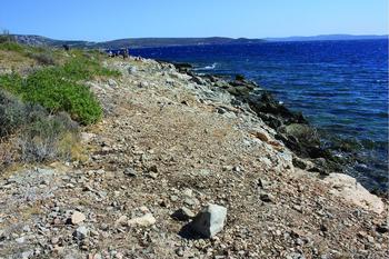
In 2016, pedestrian survey along the south-eastern coastline of the Karaburun Peninsula recorded a 0.3ha site (site 35) with a relatively intense distribution of human-made chipped stones over Triassic limestone bedrock (Erdoğan et al. Reference Erdoğan, Altıner, Güngör and Özer1990). Located on a west–east oriented slope, the chipped stones extended for approximately 80m along the shore (Figure 1). The area had good surface visibility with partial covering of evergreen shrubs (Figure 2). A team of nine people surveyed the area in 2m transects, collecting over 300 lithics. The only other archaeological find recovered was a corroded Byzantine-era coin.

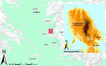
Figure 1. The location of the Karaburun Peninsula and sites mentioned in the text.

Figure 2. General view of site 35 from the south (photograph by Ç. Çilingiroğlu).
The chipped stones from site 35
The chipped stones comprise almost entirely white-patinated chert (originally dark grey), although red, pink, orange and grey patinas are also visible on some pieces. The quality of the raw material is mainly normal to poor, with good quality material recorded only on 47 pieces. Cortical pieces are rare in the assemblage (n = 46), indicating that the raw material sources are not located close to the site and that early stages of reduction took place elsewhere.
Of the 26 cores identified in the assemblage, eight are blades or bladelet cores. The cores are highly reduced and microlithic in character, with lengths ranging from 16–29mm and widths from 10–39mm. Nearly half of all the identified blanks at the site are flakes (n = 180), and around 16 per cent of the whole assemblage comprises blades and bladelets (n = 57). The sizes of the blanks are also microlithic in scale, with flakes measuring 6–28mm in length, and blades measuring 6–33mm in length.
Among the blanks, only 52 pieces show signs of retouch, constituting 14 per cent of the entire assemblage. Retouched pieces are further classified according to their tool types. Among these are side-scrapers (n = 4), end-scrapers (n = 10), retouched flakes (n = 21), retouched blades (n = 6), notches (n = 2), a burin, a perforator, a lunate and a composite tool (in this case, a tool with three different kinds of retouch on its three sides) with a denticulated edge. Tools mainly exhibit scalar, fine, marginal, abrupt and stepped retouch (Figures 3 & 4).

Figure 3. A selection of chipped stones from site 35: a–c) scrapers; d) perforator; e) burin; f): lunate; g–h) retouched blades; i) bladelet core (drawing by D. Turan).

Figure 4. The single lunate from the site 35 assemblage (photograph by C. Bayak).
Discussion
The microlithic character of the assemblage and the relatively large proportion of blades and bladelets contrast with an open-air site (site 31) discovered previously by the KASP, which was tentatively assigned to the Aegean Mesolithic tradition (Çilingiroğlu et al. Reference Çilingiroğlu, Dinçer, Uhri, Gürbıyık, Baykara and Çakırlar2016; Çilingiroğlu Reference Çilingiroğlu2017). The very small size of the cores and the presence of microlithic flakes and bladelets—as well as geometric pieces such as the lunate—from site 35 allows for general comparisons with the “flake-bladelet industries” of Pleistocene/Holocene Epigravettian tradition (Kaczanowska & Kozłowski Reference Kaczanowska and Kozłowskı2014: 35). Moreover, some typo-technological similarities can be identified with the Final Pleistocene site of Ouriakos on Limnos, where lunates only comprise a very small (1.25 per cent) portion of the site's assemblage. The size of the site 35 lunate (Figures 3 & 4) is also very similar to that of the Ouriakos lunates, which are 12–22mm long and 2.3–3.5mm thick (Efstratiou et al. Reference Efstratıou, Bıagı and Starnını2014: 6). Based on our preliminary observations and available comparative material from the eastern Aegean, we propose that site 35 was a short-term, Late or Final Pleistocene, forager site. In the absence of comparative sites from western Anatolia and absolute dates from site 35, this suggested dating remains tentative at best. Future studies should provide a clearer assessment of the site and its date.
Acknowledgements
The project is conducted with the permission of the Turkish Ministry of Culture and Tourism, and is supported by the Ege University Research Fund (grants: 2015-EDB-005; 2016-EDB-018), Groningen University Institute of Archaeology and the Municipality of Karaburun.