


Introduction
Montagu’s Harrier Circus pygargus is an open grassland and farmland raptor of high conservation concern that is listed on Annex I of the Wild Birds Directive (2009/147/EC) as a species that is considered vulnerable in the European Union (EU), and on Appendix II of the Bern Convention. However, the status of Montagu’s Harrier remains questionable inside its range (Bashta and Domashevsky Reference Bashta, Domashevsky, Wiącek, Polak, Kucharczyk, Grzywaczewski and Jerzak2009, Terraube et al. 2010, BirdLife International 2015). Some European countries have placed this species on national red lists (Trierweiler Reference Trierweiler2010). However, within many EU countries, information regarding trends of the breeding population of Montagu’s Harrier is imprecise (Terraube et al. 2010), partly due to non-comparable methods in estimating population abundance. In the European Red List of Birds it is still considered as being of least concern because of the large population estimated in European Russia (BirdLife International 2015), although the latter is not based on systematic surveys. It is currently not included in the Polish Red Book (Głowaciński Reference Głowaciński2001).
In Poland, the Montagu’s Harrier represents a scarce lowland breeding raptor that occurs mainly within the eastern part of the country, i.e. Podlasie, Mazovia and the Lublin area (Tomiałojć and Stawarczyk Reference Tomiałojć and Stawarczyk2003, Sikora et al. 2007, Kuczyński and Chylarecki Reference Kuczyński and Chylarecki2012) and nests mostly in cereal crops (Sikora et al. 2007, Krupiński Reference Krupiński, Zawadzka, Ciach, Figarski, Kajtoch and Rejt2013). The population size and distribution of Montagu’s Harrier within Poland were insufficiently detailed before the turn of the 20th and 21st centuries due to incomplete or missing data.
Available information suggests that the population of Montagu’s Harrier in Poland apparently increased after the 1970s, when it was assessed at approximately 230 pairs (Tomiałojć Reference Tomiałojć1990). At the end of the 20th century, the national population of this species was assessed at 1,300–1,500 breeding pairs (Tomiałojć and Stawarczyk Reference Tomiałojć and Stawarczyk2003, Sikora et al. 2007). The increase of the Montagu’s Harrier population at this time likely resulted from decreased hunting pressure after its inclusion on the protected species list in 1975, as well as the dichlorodiphenyltrichloroethane (DDT) recall from Polish agriculture in the late 1970s. Another possible reason could have been the colonisation of a new nesting habitat (crops) and the subsequent expansion of the “farmland” population (Arroyo et al. 2002, Kitowski Reference Kitowski2002, Terraube et al. 2010, Poprach et al. 2013, Santangeli et al. 2014). However, at the same time opposite trends were recorded within some regular breeding sites (Kitowski Reference Kitowski2002), and since the end of the 20th century ornithologists have raised the alert about the adverse status of this species in certain locations (Tomiałojć and Stawarczyk Reference Tomiałojć and Stawarczyk2003, Krupiński Reference Krupiński, Zawadzka, Ciach, Figarski, Kajtoch and Rejt2013). According to the results of the Monitoring of Birds of Prey project, the Polish population of Montagu’s Harrier decreased at the rate of 8% between 2007 and 2012, which is equivalent to a c.50% decrease within 10 years (Chodkiewicz et al. 2015, Krupiński et al. 2015).
Progressive land-use changes resulting from the extensive farming abandonment and agricultural intensification (Butet and Leroux Reference Butet and Leroux2001, García and Arroyo Reference García and Arroyo2002, Avilés and Parejo Reference Avilés and Parejo2004, Kragten et al. 2011) will influence the status of the Montagu’s Harrier and potentially foster further population declines. In the face of dynamic and unpredictable human-induced landscape transformations, conservation managers should be made aware of problems of population persistence, both current and emergent, but they require exhaustive and up-to-date population data to implement effective conservation measures. In view of the currently limited resources available for this, it is imperative to develop survey methods that are both reliable and affordable.
In this paper, we present the design, methodology and results of the first national quantitative survey of the Montagu’s Harrier in Poland. We also show how data originating from various citizen science programmes can be used to design a rigorous survey at broad spatial scales. Finally, we briefly discuss the implemented methods and provide recommendations for future surveys.
Methods
Survey design
The 2013–2014 survey was designed to estimate the size of the breeding population of Montagu’s Harrier in Poland by sampling 100 10*10 km squares. However, according to Sikora et al. (2007), Montagu’s Harrier only occupied approximately one third of the country’s area, which made the application of simple random sampling ineffective because the majority of plots would be selected outside the species’ core distribution range. To overcome this, we divided the area of Poland into four strata, according to the habitat suitability for the Montagu’s Harrier that was evaluated by a predictive model built using data originating from citizen science programmes and gathered during the pre-survey period. The procedure of stratification, the selection of sampling plots and density estimation are described below and summarised in Figure 1.
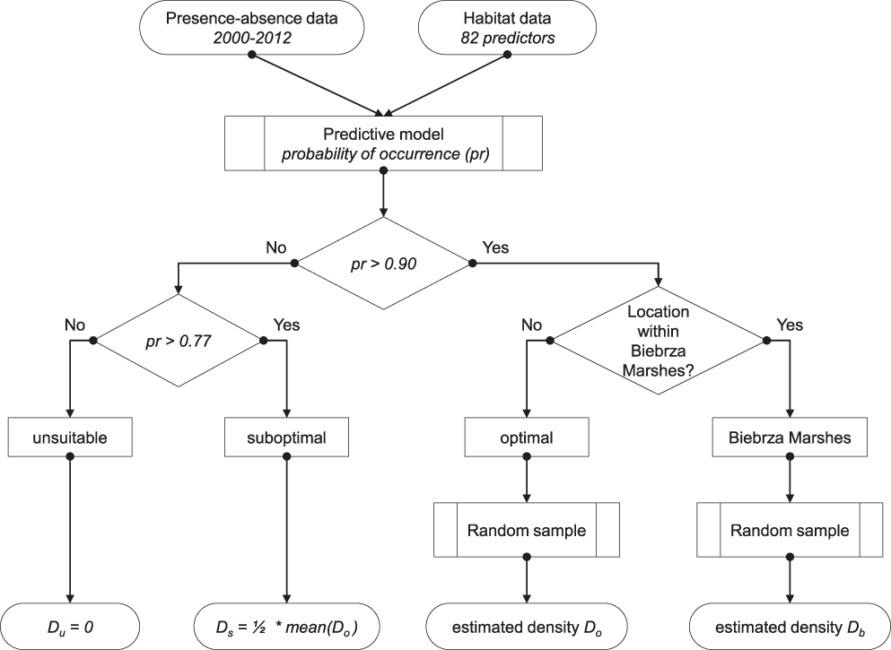
Figure 1. Flowchart summarising the procedure of stratification, selection of sampling plots and estimation of population densities within each stratum.
Predictive distribution model
The model was built on the basis of presence-absence data gathered during 2000–2012 and extracted from several citizen-science ornithological databases (see Acknowledgements). All the available georeferenced observations were spatially matched to the appropriate recording unit, which was the 10*10 km square of the national grid PUWG 1992 (EPSG: 2180). The records extracted from the databases contained information on breeding status (proved, probable or possible breeding), and those which were classified as “possible” were excluded from the training data set. Altogether, 809 records were acquired in this way: 493 were presence and 316 were absence squares. This data set was unbalanced (presence to absence ratio: 1.56), and classification algorithms are known to be biased in such cases (He and Garcia Reference He and Garcia2009). Thus, to balance the data, 177 pseudo-absences were generated using the following algorithm:
1. Select a predefined set of unsuitable squares (U). Montagu’s Harrier is known to avoid human settlements and forests (Cormier et al. 2008, Trierweiler et al. 2010, authors’ unpubl. data). Based on the distributions of the land cover characteristics calculated for squares with recorded presence, unsuitable squares were defined as those with artificial surfaces (CLC class 1) covering > 15% of the square area or with forests (CLC class 3) covering > 75%.
2. Select randomly k pseudo-absences from the set of unsuitable squares defined in the previous step (U), where k is the number of pseudo-absences needed to balance the data.
3. Form a balanced training data set (B) by merging true-presences, true-absences and pseudo-absences selected in step 2.
4. Fit a random forest to the data generated in step 3.
5. Calculate the predicted probabilities of Montagu’s Harrier presence (pr) from the model fitted in step 4.
6. Re-define the set of unsuitable squares U as those meeting the condition pr < 0.1. Retain only those false-absences in B that are also present in U. Calculate k.
7. Repeat steps 2–6 until k = 0.
Balancing the learning data set substantially improved the model predictions (Appendix S1 and Table S2 in the online supplementary material).
The habitat data used as predictors for the predictive distribution model are explained in detail in the supplementary material (Appendix S1; Table S1). In general, a total of 82 environmental variables were used from the following sources: (1) Corine Land Cover database; (2) landscape characteristic derived from Corine Land Cover using Fragstat software (McGarigal and Marks Reference McGarigal and Marks1995); (3) SRTM digital elevation; (4) bioclimatic variables; (5) vegetation phenology; (6) farming variables derived from Polish Agricultural Census 2002; and (7) DMSP-OLS night-time lights.
The random forest (RF) algorithm (Breiman Reference Breiman2001), which was used for building the predictive distribution model, represents a machine learning method based on classification and regression trees (CART). It constructs multiple trees, each fitted to randomly perturbed data, where a single tree is produced from a random sample of cases and each split from a random sample of predictors. The final output is achieved by voting. The bootstrap mechanism ensures that approximately one-third of the instances are left out and not used in the fitting process. These out-of-bag (OOB) samples are used to assess the prediction error of the procedure, which overcomes the common problem of bias of prediction error.
The model achieved good accuracy: the OOB classification error rate was less than 6%. The distribution of model residuals and model performance parameters are presented in the Supplementary Material (Appendix S1; Figure S1, Table S3). We did not explore the habitat use of Montagu’s Harrier in this paper, so we did not interpret the model in detail here. For the purpose of this study, predictions from the model were necessary for the delimitation of the following sampling strata:
1. Optimal stratum. It comprised the area with a very high probability of Montagu’s Harrier occurrence, arbitrarily defined as those 10-km squares for which the predicted probability of presence pr (obtained from the aforementioned habitat model) was greater than 0.9 and provided that they were not within the Biebrza Marshes (a separate sampling scheme was designed to estimate the number of birds breeding there - see the following paragraph). The optimal stratum had an extent of 111,429 km2.
2. Biebrza Marshes stratum. The Special Protection Area “Ostoja Biebrzańska” (Biebrza Marshes; PLB200006; 1,485 km2) was reported in the literature as the country’s main breeding area, hosting over 2% of the national population (Sikora et al. 2007, Krupiński Reference Krupiński, Zawadzka, Ciach, Figarski, Kajtoch and Rejt2013). For this reason, this area was separated from the optimal stratum, and a distinct sampling scheme was designed for the population assessment in this area.
3. Suboptimal stratum. This included all 10-km squares with predicted probability of Montagu’s Harrier occurrence between 0.9 and 0.77 (Appendix S1, Figure S2). The area of this stratum was 38,713 km2.
4. Unsuitable stratum. All of the other remaining squares formed this stratum, with the predicted probabilities of occurrence between zero and 0.28. The unsuitable stratum had an extent of 160,270 km2.
Selection of sampling plots
Field surveys were made exclusively within the optimal and Biebrza Marshes strata. Different sampling schemes were used, due to the different spatial extents of those areas.
For the optimal stratum, 100 of the 10-km squares were randomly selected. Sampling was proportional to prediction values: the higher the prediction values from the model, the higher the chance of selection of a particular square. Additionally, the distance between each pair of squares was calculated at each turn, and if a newly added square was adjacent to another one, it was eliminated. The procedure was repeated iteratively until a required number of squares was obtained. The resulting locations of the sampling plots are shown on Figure 2.
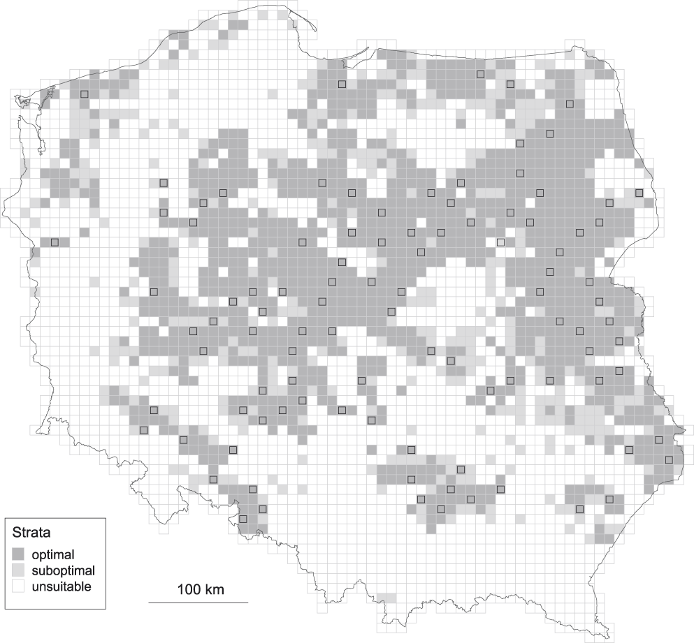
Figure 2. Location of sampling plots within the optimal stratum.
The surveys within Biebrza Marshes were conducted in 30 2-km squares randomly chosen from the set of 215 squares meeting the two criteria: 1) at least 50% of the square area was situated within the SPA ’Ostoja Biebrzańska’ and 2) woodlands covered, at the very most, 50% of the square area. The locations of the sampling plots within the Biebrza Marshes stratum are shown in Appendix S2, Figure S3.
Fieldwork methods within optimal stratum
The survey encompassed two visits to 10 points located within the selected 10-km squares, between early May and late July (first visit between 5 and 25 May and second visit between 1 and 20 July). Highly experienced ornithologists were involved in the survey. Observers were asked to verify in the field whether preselected viewpoints rendered an adequate view. The points should provide a wide, uncluttered view of all of the possible Montagu’s Harrier breeding and hunting habitats (i.e. cereal fields, meadows, wastelands and scrub) around the point. Otherwise, observers were charged with moving the given point to improve surveillance conditions. Observers spent 30 minutes at each point. Observers used binoculars to scan for perched or flying raptors and recorded bird locations on a handheld GPS and on a 1:40,000 map. To avoid double counting the observers plotted their observations on a map. The number of Montagu’s Harrier territories was estimated on the basis of interpretation of notes and marked maps. We interpreted and classified Montagu’s Harrier territorial behaviour and breeding status using criteria by Sim et al. (2001).
We used a double observer approach to estimate the detectability of Montagu’s Harrier territories using the methodology proposed in Nichols et al. (2000) and MacKenzie et al. (2006). Different observers were asked to make independent counts according to the same protocol described above (i.e. two whole-day visits, one in May and one in July). Double counts were made for 30 squares selected at random (12 squares in 2013 and 18 squares in 2014). Observers were not provided with any information that could possibly influence the outcome of their assessments.
Fieldwork methods within Biebrza Marshes
The survey was conducted in 2-km squares and encompassed two all-day visits between early May and late July. Experienced ornithologists were involved in the survey. Observers were required to apply the above-described procedure (see Fieldwork methods within optimal stratum) and verify the locations of the viewpoints, move (if necessary) the locations of the viewpoints, and conduct the observations. They needed to spend 60 minutes at each point.
Data analysis
Statistical analyses were performed using JAGS Gibbs-sampling environment (Plummer Reference Plummer2003) and R 3.2 (R Development Core Team 2015). Both environments were integrated via the R2Jags library (Su and Yajima 2015). The JAGS code used for the estimation of the population density is included Appendix S3. All estimates are given with corresponding 95% credible intervals (CI thereafter).
Calculation of population estimates
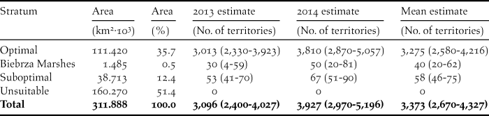
The total size of the breeding population of the Montagu’s Harrier was calculated by summing the numbers estimated in three mutually exclusive strata: “optimal”, “suboptimal” and Biebrza Marshes. The density in the “unsuitable” stratum was assumed to be zero.
“Optimal” stratum
The number of Montagu’s Harrier territories within each sampling square was estimated using the following Bayesian hierarchical model:
 $$\eqalign{ &amp; {y_{ij}}{\rm{\~}}Pois({\lambda _{ij}} \cdot p) \cr &amp; \ln ({\lambda _{ij}}) = {\alpha _j} + {\varepsilon _i} \cr &amp; \varepsilon {\rm{\~}}N(0,\delta ) \cr}$$
This model assumes that the number of territories y ij found on the plot i in the year j follows the Poisson distribution, with the expectation being the product of the “true” number of territories λ ij and estimated detectability of a single territory p. The detectability was estimated for the subsample of 30 plots surveyed by two independent observers using the parameter-expanded data augmentation method (Royle et al. 2007, Royle and Dorazio Reference Royle and Dorazio2012). Due to small sample size, estimates of detectability for both seasons were pooled. The number of territories (log-transformed) is the function of fixed year effect α j and the random plot effect ε i, which is normally distributed with the mean zero and variance δ 2. This model allows for over-dispersion, imperfect detection and separate estimation of yearly effects. The total number of territories in the stratum was calculated by multiplying the mean density (i.e. the mean value of λ) by the stratum area.
“Suboptimal” stratum
The number of squares meeting the condition 0.77 < pr < 0.9 was 392. However, based on the pre-survey presence-absence data, we found that 40 of these squares were in fact occupied. From this, the rough and conservative proportion of occupied squares in the “suboptimal” stratum was estimated: q = 40/392 = 0.102. The density of territories in this stratum remains unknown and was assumed to be a half of that in the “optimal” stratum. This guess was based on the following clue: we fitted a smooth line to the relationship between predicted population density and predicted probability of occurrence of the Montagu’s Harrier in all 10*10 km squares (Figure 3). Then, we calculated expected densities for the middle-points of probability classes which we used to separate strata. Those values were: 0.57 and 1.32 territories/100 km2. The ratio of these values is 2.3 which is quite close to the value of 2 that we chose. This multiplier has very little effect on final population size estimates. If we assume the value of 2 (as we chose), estimated number of territories in “suboptimal” stratum is 58 (vs. 3,275 in the whole country) which constitutes only 1.7%. The total number of territories in the “suboptimal” stratum was calculated by multiplying the (guessed) mean density of territories (i.e. the mean value of λ/2) by the proportion of occupied squares (q) and the stratum area.

Figure 3. Relationship between the predicted population density and predicted probability of occurrence in all 10*10 km squares across Poland. Vertical lines represent 0.77 and 0.90 probabilities. Black dots show expected densities for the mid-points of those probability classes.
“Biebrza Marshes” stratum
The total number of territories was calculated by multiplying the mean density of territories estimated for the surveyed squares by the area of suitable habitats within this stratum (see paragraph Selection of sampling plots above).
Results
Altogether, in the 30 squares sampled by two independent observers, 77 territories were found (30 territories were detected by both observers and 47 by only one of them). Thus, the field methodology used in this study puts the estimate of territories detectability at 55.2% (CI 43.5–66.2).
The number of territories detected per square ranged from zero to 13 (Figure 4), and averaged 1.60 (CI 1.41–1.81). After accounting for imperfect detectability, mean estimated population densities were 2.93 territories per 100 km2 for the optimal layer and 1.07 territories per 100 km2 for the whole country area (which included optimal, suboptimal and unsuitable habitats, Table 1). Based on those estimates we assessed the total size of the Polish Montagu’s Harrier population at 3,373 (CI 2,670–4,327) breeding pairs during the two-year survey (Table 2).

Figure 4. Frequency distribution of number of territories detected on sampled 10*10 km squares in 2013 and 2014.
Table 1. Estimates of Montagu’s Harrier population mean densities within Poland given in the number of territories per 100 km2. The 95% confidence intervals are given in parentheses.
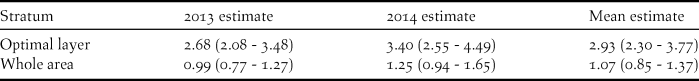
Table 2. Estimates of Polish national population of the Montagu’s Harrier. The 95% confidence intervals are given in parentheses.
Discussion
This study provides the first quantitative estimate of the Montagu’s Harrier breeding population in Poland. Our results highlight the European importance of Poland for the EU’s breeding population of this raptor. This study shows also the value of using existing volunteer-based data while designing national bird surveys.
Population status of Montagu’s Harrier in Poland
We estimated the Polish breeding population of Montagu’s Harrier at approximately 3,400 breeding pairs. Our results thus indicate that the Polish population represents 20% of the EU’s population of this species, which amounts to approximately 18,000 breeding pairs according to Trierweiler (Reference Trierweiler2010). Poland hosts the third largest breeding population of Europe (excluding Russia), following Spain and France - these three countries sustain approximately 80% of all Montagu’s Harriers breeding in the EU. According to BirdLife International (2004), the largest breeding population occurs within European Russia where it was reported to show an increasing trend at the end of the 20th century, although both population and trends there have been labelled as “insufficiently quantified” (Terraube et al. 2010). The current European status for the species is ‘Least Concern’ (LC), the justification being that although the European population appears to be decreasing, the decline is not believed to be sufficiently rapid to approach the thresholds for ‘Vulnerable’ (BirdLife International 2016). However, insufficient up-to-date reliable European estimates regarding the population size and trends are available.
Montagu’s Harrier population assessments from the last decade are only available for certain countries, and sometimes there is only one estimate so no information on trends exists. For example, the latest estimates for Spain - the stronghold of this species in EU - come from 2006 (BirdLife International 2015), with breeding populations estimated at 6,100–7,400 pairs, and it was considered then that the survey method used that year did not allow reliable comparisons with previous (more qualitative) estimates to allow good inferences of trends (Arroyo and García Reference Arroyo and García2007). In France, the last national census was made in 2000 and estimates were of 3,900–5,100 breeding pairs (Millon et al. 2004). Subsequently, standard monitoring in a sample of selected quadrats linked to predictive modelling has shown that the population has experienced non-significant declines from 2000 to 2013 (Le Rest et al. 2015). Populations in other central and eastern European countries are much smaller, and trends even less well evaluated. For example, the population of this raptor in the Czech Republic was estimated at only 170–200 pairs around 2013 (Poprach et al. 2013), probably due to the predominantly upland-alpine land form, unfavourable for Montagu’s Harrier. In the case of other eastern EU member states, the latest estimates come from the end of the 20th century or beginning of the 21st century (e.g. Tóth Reference Tóth2002), or concern only particular parts of the country. The last assessment of this species’ population size in Poland come from the first decade of the 21st century (Sikora et al. 2007). However, these assessments may be burdened with e.g. unevenly distributed workforce and high percentage of zero-plots, and thus underestimated. We highlight the need to acquire up-to-date data concerning the status of native populations of this species within other European countries.
Although the population of Montagu’s Harrier in Poland is declining rapidly (Chodkiewicz et al. 2015, Krupiński et al. 2015), it is still relatively numerous (this study). The landscape configuration with the dominance of lowlands (MH prefers flat areas with large proportion of arable land; Estrada and Arroyo Reference Estrada and Arroyo2012), relatively extensive agriculture (land modification still has not led to a collapse of the population of this raptor) and possible immigration from neighbouring Ukraine, Belarus and Russia may support current breeding numbers of over 3,000 pairs.
Survey design and possible sources of bias
When designing a survey for a species that occupies a restricted or irregularly distributed range, like Montagu’s Harrier, the application of simple random sampling would be ineffective because the majority of plots would likely be selected out of the species core distribution. Here, we propose a three-step approach to increase efficiency in the sampling design: 1) to use previously collected data in order to delineate regions of high habitat suitability, 2) to restrict random sampling scheme to those areas of high probability of species occurrence, and 3) to assess effectiveness of the fieldwork by estimating detectability. This approach can likely boost survey effectiveness and reduce its costs, while rendering more accurate and comparable results among surveys (and thus better estimates of population trends). However, one must be aware of possible biases of this methodological shortcut, as all the above steps are prone to sampling errors. An uneven spatial distribution and unbalanced presence-absence pre-survey data may heavily bias predicted habitat suitability, which in turn may impact the delineation of the core distribution area. Heterogeneity amongst observers’ abilities and hence the quality of detectability estimates may also influence the final population size estimate. However, the Bayesian approach proposed here allows for restrictive error estimation at each step of the aforementioned procedure and proper error propagation, which provides reliability measures for final estimates.
Recommendations for future surveys
This study shows the value of using existing volunteer-based data while designing bird surveys. Many volunteer-based ornithological projects have expanded rapidly within Europe, e.g. the eBird program (Sullivan et al. 2009, Santangeli et al. 2015). Even if unevenly distributed, volunteer workforce may allow to identify demographic signals across and within species, and locate new breeding sites of scarce species (Robinson et al. 2014). Such databases offer great potential for gaining large-scale data by researchers and conservation managers, especially given the underfunding of conservation budgets in Europe (Tulloch et al. 2013, Santangeli et al. 2015), and may even outperform local scientific programs data due to their broader spatial scale and thus higher representativeness (Braunisch and Suchant Reference Braunisch and Suchant2010).
Conservation managers need up-to-date knowledge about the size of the target population and periodic evaluation of its status (abundance and trends), to follow the changes the population undergoes, reveal presumptive fluctuations, and propose further conservation measures. This is important because the application of conservation decisions based on wrong population assessments could have deleterious consequences for population’s persistence. The approach proposed in this study allows designing cost-efficient census programmes that could thus be more affordable by conservation managers to achieve this objective.
In the case of our study example, for example, although the results suggest that the Polish population of this raptor is larger than previously estimated, we must remain cautious while establishing population trends and conservation status to implement management schemes. We therefore recommend that monitoring of Montagu’s Harrier is continued in Poland under the first national census guidelines (Krupiński et al. 2015). Indeed, regular monitoring schemes should be implemented in other EU member states. We believe that considering the strengths and weaknesses of our approach will help to design future surveys, both for this and other study species.
Supplementary Material
To view supplementary material for this article, please visit https://doi.org/10.1017/S0959270917000235
Acknowledgements
The national Montagu’s Harrier survey was a part of the project “Montagu’s Harrier protection in Poland”. This project is supported by the European Union from the resources of the European Regional Development Fund within the Operational Program Infrastructure and Environment, by the National Fund for Environmental Protection and Water Management (NFOŚiGW) and by the Society of Nature Protection “Stork” (POIS.05.01.00-00-381/12).We express our gratitude to all the Polish ornithologists who shared their data from 2000 to 2012 (the whole list is available at http://pygargus.pl/cenzus/). We are grateful to the observers who contributed their data to the public databases we used: AwiBaza, Monitoring of Birds of Poland, Ornithological database for Greater Poland region, regional breeding bird atlas project for Greater Poland, database of Świętokrzyska Ornithological Group and the Polish wildlife database. We express our gratitude to the General Inspectorate of Environment Conservation (GIOŚ) for making operationally available the Corine Land Cover database for Poland. We are grateful to Vincent Bretagnolle for many valuable advice, and Tomek Chodkiewicz and Przemek Chylarecki for their comments. Our special thanks go to Beatriz Arroyo Lopez for valuable substantive advice, comments and corrections, that helped to improve this manuscript.


