


INTRODUCTION
Rabies reappeared in Italy in October 2008, after more than 10 years' absence, when the Italian National Reference Laboratory (NRL) for rabies identified a rabid fox in the northeastern region of Friuli Venezia Giulia (FVG), close to the border with Slovenia. Partial sequencing of the isolated rabies virus (RABV) strains showed 100% sequence identity with RABV isolates in Slovenia, Croatia and other West Balkan countries [Reference De Benedictis1]. As a result, Italy lost its rabies-free status in 2008. Three oral rabies vaccination (ORV) campaigns in foxes, conducted in FVG between January and September 2009 by manual distribution of vaccine baits exclusively, were able to reduce rabies incidence in the core area close to the Slovenian border, but failed to stop the spread of the disease. At that time, competent authorities were still relying on experiences from previous ORV campaigns, when rabies was eradicated from the same area [Reference Balbo, Rossi, Pastoret, Brochier, Thomas and Blancou2]. However, it became clear that the 2009 ORV campaigns proved inadequate to limit the westward spread of the infection, due to inaccurate spatial planning and definition of vaccination and rabies surveillance procedures in specific areas, as well as to increased fox population densities [Reference Macdonald, Reynolds, Sillero-Zubiri, Hoffmann and Macdonald3]. As a result, the disease spread further inland and, in November 2009, rabies was detected in the Veneto region (province of Belluno) more than 55 km and 60 km west, respectively, of the last outbreak and the western limit of the area vaccinated in September 2009. Since rabies emerged in an unprotected fox population, within a month it had spread to the Dolomiti Mountains, in the province of Belluno. The risk of fox rabies spreading to previously rabies-free areas forced the competent authorities to take immediate action. Two emergency ORV campaigns were conducted in December 2009–January 2010 and in spring 2010 to address the problem. Spatial evaluation of the territorial coverage and rabies cases was an integral part of the monitoring of these emergency ORV campaigns, making it possible to promptly adapt the vaccination strategy. The analysis revealed the existence of residual rabies foci at higher altitudes in the Alps than expected.
We describe an explorative spatial analysis technique that allowed identification of those rabies residual foci at higher altitudes and potential implications for ORV campaigns in countries with similar geographical features.
METHODS
Emergency ORV campaigns
Between 28 December 2009 and 20 January 2010, an emergency ORV campaign was conducted in northeastern Italy according to EU recommendations to contain further spreading of the disease inland [4]. The vaccination area was defined by a 50-km buffer around the geographical location of the most southerly and most westerly positive foxes, and extended to natural or artificial barriers. The total vaccination area was 18 200 km2 (Fig. 1a). Suitable zones for bait distribution in the Alps and elsewhere were identified using GIS software, taking into account geomorphological and hydrological characteristics of northeastern Italian regions as well as urban settlement areas. Furthermore, as winter was approaching, consideration had to be given to: (i) the stability of attenuated rabies vaccine viruses at low temperatures, and (ii) the fact that the frozen vaccine cannot be released into the mouth cavity when the blister is punctured [Reference Pastoret and Brown5]. Therefore, the freezing-point altitude was delineated for exclusion. As a result, only zones below the altitude of 1000 m above sea level (a.s.l.) were vaccinated in the emergency ORV campaign, and suitable zones for bait distribution encompassed about 8100 km2 (Fig. 1a).

Fig. 1. Vaccination area and suitable area for (a) the December 2009–January 2010, and (b) April–May 2010 emergency oral fox vaccination campaigns.
In spring, a second ORV campaign was conducted that extended further westward to include the provinces of Trento and Bolzano, where in early 2010 single rabies cases had occurred in these two provinces in areas close to the province of Belluno. Part of the FVG region to the east was also vaccinated. In the mountainous areas, based on the average freezing point of the past 10 years in the Alps in springtime, suitable zones with a threshold altitude of up to 1500 m a.s.l. were baited without compromising vaccine efficacy. Therefore, the size of the spring vaccination area increased to 29 700 km2 with suitable zones for bait distribution <1500 m a.s.l. encompassing 19 150 km2 (Fig. 1b). The spring ORV campaign began on 23 April 2010 but, due to harsh weather conditions and other technical constraints, vaccination was suspended for about 10 days in mid May. During this period, an explorative spatial analysis of rabies cases reported in previous months was performed before the spring vaccination resumed (24 May–28 June 2010).
In both ORV campaigns, vaccine baits were distributed by helicopters, at a density of 20–30 baits per km2. Complementary hand distribution of baits was conducted in urban areas and small mountain valleys where aerial distribution was not practical.
Data source
Base maps used in the spatial analysis included the administrative boundaries up to Local Administrative Unit 2 (LAU 2; i.e. municipality level) at a nominal scale of 1:250 000. The orography of the area was obtained from a Digital Elevation Model (DEM; SRTM 2000) [Reference Farr6]. For each animal submitted for rabies diagnosis from FVG, the Veneto region and the provinces of Trento and Bolzano during the study period, individual datasets were available from the NRL on species, age, sex, location, date found, and the results of the laboratory rabies diagnostic test, i.e. the fluorescent antibody test (FAT), tissue culture isolation test (TCIT) and RT–PCR [Reference Fooks and Horton7]. Information on the location of rabies positive and negative animals was based on administrative units where the foxes were found (province and municipality), other known geographical features (i.e. rivers, roads, forests, valleys, etc.) including their approximate distance to the place animals were found, or geographical coordinates if available. This information was reported on a detailed map of the territory, at a nominal scale of 1:10 000, allowing localization of the points where the animals were found with sufficient accuracy. Data on the geographical location of animals was then transferred to GIS software and combined with altitude data (extracted from DEM) and laboratory tests.
Spatial analyses of rabies cases and creation of ORV areas were conducted through ESRI® ArcMAP™ GIS software and the Spatial Analyst and Spatial Statistics Toolboxes [Reference McCoy and Johnston8, Reference Mitchell9].
Only positive foxes collected between the initial spread of rabies to Veneto (23 October 2009) and the start of the second part of the spring vaccination (24 May 2010) were included in the explorative spatial analysis.
Spatial analysis
A preliminary visual explorative analysis was performed by classifying rabies-positive foxes according to the altitude where they were collected. Three classes were created, by conservatively considering the threshold altitudes of vaccination campaigns in December/January 2009/2010 and spring 2010. Class I encompassed all rabies-positive foxes found at altitudes <900 m a.s.l., class II included cases between 900 and 1500 m a.s.l., class III those >1500 m a.s.l. [Reference Capello10]. A more in-depth spatial analysis was performed to detect significant aggregations (residual foci) of rabies-positive foxes above the threshold altitudes of the respective vaccination areas. The level of autocorrelation between the geographical locations where positive foxes were collected was evaluated using the G i*(d) statistic [Reference Getis and Ord11, Reference Ord and Getis12], with altitude as the variable of interest. The spatial relation between points was conceptualized as the inverse of the Euclidean distance between locations.
Significant hotspots were identified as having a Z i score ⩾1·96 (P⩽0·05), indicating points with high altitudinal values which were surrounded by points with similar high values.
RESULTS
From 23 October 2009 to 24 May 2010 a total of 201 rabies-positive foxes was reported by FVG, the Veneto region and the provinces of Trento and Bolzano at altitudes between 40 and 2224 m a.s.l. (mean 1021·124, 95% CI 965·2–1077·04) (Fig. 2). While 71 (35%) and 106 (53%) rabid animals were reported from altitudes <900 m a.s.l. and between 900 and 1500 m a.s.l., respectively, 24 (12%) rabies cases originated from areas at altitudes >1500 m a.s.l. (min 1502, max 2224, mean 1689·71, 95% CI 1613·65–1765·77). Of these 24 rabies cases, three (12·5%) and 21 (87·5%) occurred before and after the winter emergency ORV campaign, respectively, considering the pre-/post-winter vaccination periods defined by Capello et al. [Reference Capello10] (Table 1).
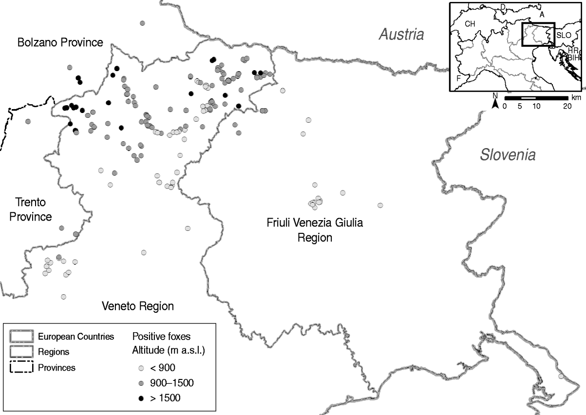
Fig. 2. Distribution of rabid foxes between 23 October 2009 and 24 May 2010.
Table 1. Number of rabid foxes found before and after the efficacious winter vaccination period and per altitude class.
* Period was defined as in Capello et al. [Reference Capello10]: pre-winter vaccination: 23 October 2009 to 3 March 2010; post-winter vaccination: from 4 March 2010.
The spatial analysis performed through G i*(d) identified three hotspots (possible rabies residual foci) around which positive foxes were found at altitudes that were significantly higher than the mean (P⩽0·05) (Fig. 3, Table 2). All of the detected hotspots were located above the threshold altitude of 1500 m a.s.l. considered suitable in the spring ORV campaign, and hence these were excluded from vaccine distribution. Determination of the distances between the significant residual foci and their nearest-neighbour points revealed that seven rabid foxes were found within a radius of about 2400 m from hotspot no. 2 (between-points distances in this area: min 61·68 m, max 3583·70 m, mean 1681·45 m). All of those rabid foxes were located at >1500 m a.s.l. (min 1585, max 2000, mean 1675·14) between 11 April and 14 May 2010.
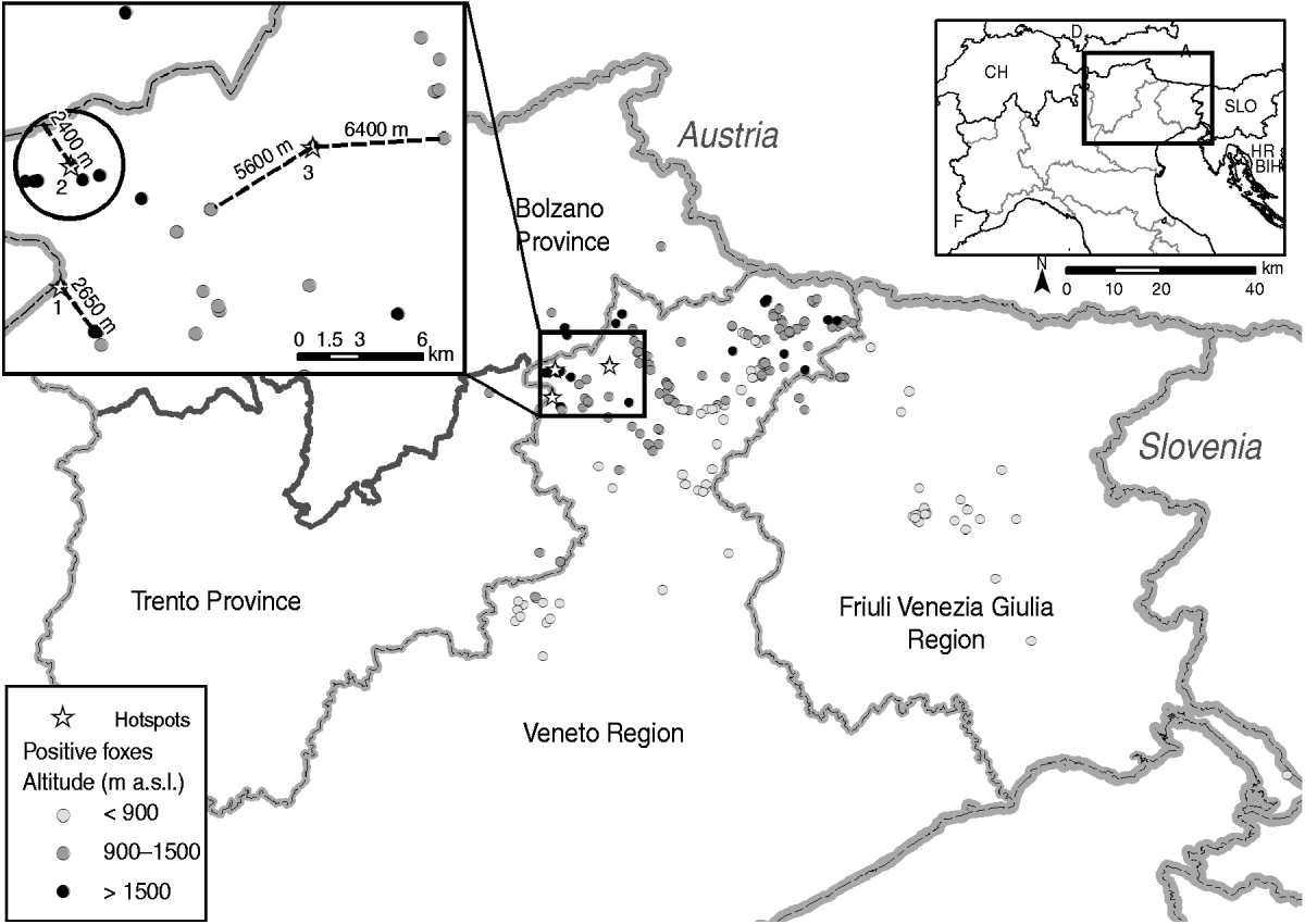
Fig. 3. Geographical location of rabies hotspots >1500 m a.s.l. The details in the panel show the distance between the detected hotspots and the nearest rabid foxes.
Table 2. Characteristics of the significant hotspots and distance from their nearest-neighbour points
DISCUSSION
Italy had already experienced rabies epizootics beginning in the mid 1970s, and successfully eradicated the disease in the 1990s using ORV [Reference Mutinelli, King, Fooks, Aubert and Wandeler13]. However, due to the geographical features of the newly rabies-affected area (e.g. the fragmented landscape of the Alps with high mountain ranges and narrow valleys) and the approaching winter, the 2009 outbreak posed new challenges for rabies control using ORV. Additional challenges included limited experience with aerial distribution of vaccine baits at the time and the need for a timely emergency response. Therefore, the first emergency ORV campaign (December 2009–January 2010) was aimed at containing rather than eliminating fox rabies in northern Italy. In this campaign at this time of the season, the prevailing adverse climatic conditions required avoidance of repeated freeze–thaw cycles of the oral rabies virus vaccine, which may lead to a decrease in virus titre on the one hand and an impaired immune response in foxes as frozen vaccine is believed not to be released into their mouth cavity when the blister is punctured [Reference Pastoret and Brown5]. Hence, these facts forced the exclusion of areas located above the freezing point from aerial distribution of baits. Therefore, the threshold altitude for vaccination was set at 1000 m a.s.l. for the winter 2009 ORV and at 1500 m a.s.l. for the spring 2010 ORV.
Although the emergency ORV was very effective in containing the westward spread of the disease, rabies unexpectedly persisted in local foci at altitudes >1500 m a.s.l. in the following months. The results of the spatial-temporal analysis provided the basis for hypothesizing the persistence of residual rabies foci at higher altitudes (>2000 m a.s.l.) in the Italian Alps (Table 2). This is surprising as those regions are considered an unfavourable fox habitat and are usually heavily covered with snow at that time of the year and even in spring time. In Switzerland, for example, no rabies cases in wildlife had ever been detected >2000 m a.s.l. [Reference Müller, Breitenmoser, King, Fooks, Aubert and Wandeler14], under climatic and orographic conditions similar to the Italian Alps. Despite an astonishing high seroconversion rate of about 77% in foxes after the emergency ORV campaign, compared to the pre-vaccination phase, the percentage of rabid animals was higher in zones above the threshold altitude of 1500 m a.s.l. in the following months [Reference Capello10] and even during the spring campaign. While the vaccination coverage in foxes in the valleys was sufficient; apparently unvaccinated foxes at higher altitudes appear to maintain an infectious cycle in isolated foci. This is supported by recent studies indicating a marked increase in the overall fox population even in the Alps [Reference Gloor15]. However, proving this hypothesis might be difficult. Wild animals are free roaming and, unlike livestock, cannot be represented as points on a map, so there might be a sampling bias [Reference Müller, Breitenmoser, King, Fooks, Aubert and Wandeler14]. In winter, foxes often move down the mountain in search of food, which may temporarily increase their density at lower altitudes [Reference Suchentrunk16, Reference Capt, Stadler, Commichau and Sprankel17]. During the mating season (January/February) there are increased interactions among foxes, increasing exposure to rabies. Nevertheless, a total of seven positive foxes were detected in the same area in a limited time within a radius of 2400 m (hotspot no. 2), which stresses the relevance of rabies foci at high altitudes as a source of re-infection. Moreover, the number of rabid foxes found >1500 m a.s.l. rapidly decreased after extending the threshold altitude to include areas up to 2300 m altitude. From 24 May to 23 August 2010 (start of the summer emergency ORV campaign, carried out up to 2300 m altitude) only 12 rabid foxes were identified (four at >1500 m a.s.l., four between 900 and 1500 m a.s.l. and two <900 m a.s.l.) (data provided by Istituto Zooprofilattico Sperimentale delle Venezie).
Our results prompted the adaptation of the vaccination strategy for the second part of the spring campaign (24 May–18 June 2010), by extending the vaccination area to a threshold altitude of 2300 m a.s.l. to include all of the detected rabies cases (Fig. 4).

Fig. 4. Distribution of the rabid foxes over the extended spring vaccination area (24 May–18 June 2010).
The presence of residual rabies foci at higher altitudes contradicts previous assumptions about bait distribution in mountainous areas [Reference Hostnik18] and should be reconsidered when implementing and adapting ORV strategies in countries sharing similar geomorphological and climatic characteristics. Emergency ORV campaigns are considered ad-hoc actions in response to a deteriorating epidemiological situation, and therefore they cannot be planned well in advance. The results of our analysis suggest scheduling of ordinary ORV campaigns in high mountainous areas during periods when climatic conditions allow in order to reach altitudes >2000 m a.s.l. without compromising vaccine efficacy. Further analyses of fox rabies in other enzootic regions in Europe, in particular those with geomorphological and climatic characteristics similar to northeastern Italy, are necessary to support our findings.
ACKNOWLEDGEMENTS
The authors thank Dr Franco Mutinelli (National Reference Laboratory for Rabies; IZSVe) and Dr Paola De Benedictis (OIE collaborating centre for diseases at the animal–human interface; IZSVe) for supervision, and Laura Gagliazzo and Monica Lorenzetto (IZSVe) for technical assistance.
DECLARATION OF INTEREST
None.


