


1.1 Surveying between Ras el-Mergheb and Ras el-Hammam (M. M.)
In 1995, in accordance with a request from the Libyan Department of Antiquities (DoA), the Archaeological Mission of Roma Tre University, directed by Luisa Musso, started an archaeological survey of the Lepcitanian territory. There was a shared need with the Libyan DoA to record and document the historical and archaeological heritage scattered across the Lepcitanian countryside; the scientific priorities were knowing and reconstructing the rural settlement and its diachronic development across the ages, from the first forms of human presence to contemporary times. For this purpose, systematic archaeological surveys were conducted along Wadi Bendar (1995), in the territory of Silin (1996–97), and along Wadi Caam-Taraglat (1999–2000) (Fontana et al. Reference Fontana, Munzi and Ricci1996; Munzi et al. Reference Munzi, Felici, Cifani, Cirelli, Gaudiosi, Lucarini and Matug2004; Reference Munzi, Felici, Cifani and Lucarini2004–2005).
In the summer of 2007, the survey's activities moved to sampling the suburban strip delimited by the heights of Ras el-Mergheb to the west, Ras el-Hammam to the east, the modern Tripoli–Misurata road to the north, and being about 5 km in width. The fieldwork took place between 18 June and 4 July 2007; it was attended by archaeologists of the Archaeological Mission, students of Roma Tre University and staff of the DoA. The effective surveys concerned an area between the coordinates UTM 33 S 0425000 (W), 0434000 (E), 3605000 (S), corresponding to the suburban fringe that lies immediately south of Mergheb, Khoms and Lepcis Magna. In total, 100 sites were identified, located via GPS and documented, relating to a chronological range from the Punic-Numidian age to the Ottoman. Four of these were documented with a planimetric survey (KHM 34–35, 45, 87). Preliminary reports have been published (Munzi Reference Munzi2010a–Reference Munzi, Tantillo and Bigib; Munzi et al. Reference Munzi, Felici, Cirelli, Schingo, Zocchi, Milanese, Ruggeri and Vismara2010; Reference Munzi, Felici, Cirelli, Schingo and Zocchi2011; Reference Munzi, Cirelli, Felici and Zocchi2013).
The last survey campaign, anticipated by some targeted inspections conducted in 2009 (some mausolea and the Gasr el-Hammam; seven sites in total) and in June 2013 (Ras el-Mergheb), was held between 22 October and 2 November 2013, reaching a total of 168 sites (Figure 1). It was attended by members of Roma Tre's Archaeological Mission, personnel of the DoA (Lepcis Magna office and the Documentation and Digitalization of Cultural Heritage Center in Tripoli), in addition to four students from Misurata University (a preliminary report is in Musso et al. Reference Musso, Baldoni, Baroni, Bessi, Bianchi, Bruno, Buccino, Davidde Petriaggi, Felici, al-Hadad, Munzi, Petriaggi, Shebani, Sjöström and Zocchi2013–14, 28–38; for the Late Antique to Ottoman periods, some data are already presented in Munzi et al. Reference Munzi, Felici, Sjöström and Zocchi2014a).
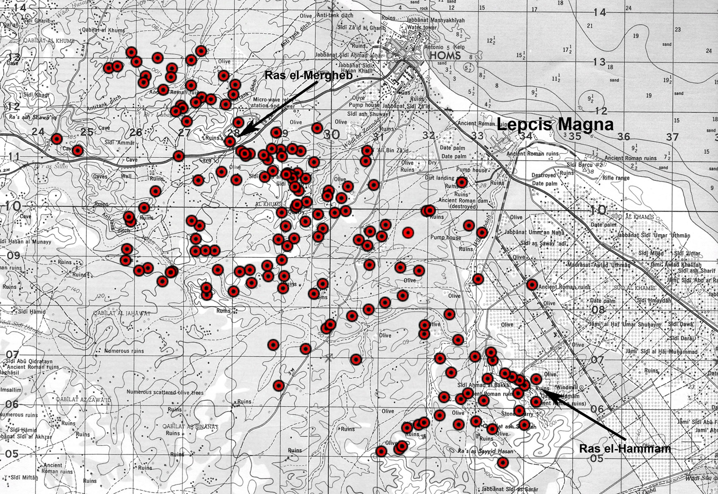
Figure 1. The sites of the 2007, 2009 and 2013 survey campaigns in the Lepcitanian territory (background image: USACE 1962a–b). (Colour online.)
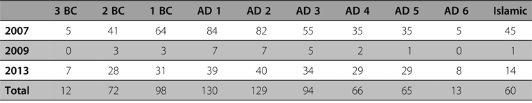
In 2013, two different territorial samples were systematically surveyed between coordinates UTM 33 S 0423700 (W), 0434500 (E), 3604000 (S) and 3613400 (N): the area north of Ras el-Mergheb and the area around Ras el-Hammam. In the surveyed 24 sq km, 61 sites have been identified, located via GPS and documented. The large quantities of pottery and coins collected on the surface of the sites have made it possible to reconstruct a detailed picture of the settlement evolution (Table 1).
Table 1 Ras el-Mergheb–Ras el-Hammam, 2007, 2009 and 2013: settlement evolution from the third century BC to the Islamic period (168 sites).
Considering all the fieldwork conducted in the territory of Lepcis Magna, about 104 sq km have been surveyed and more than 450 settlements and infrastructures have been documented to date (Table 2 and Figure 2).
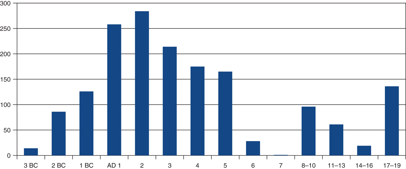
Figure 2. Lepcitanian territory, all survey samples: occupied sites since the third century BC to the late Ottoman period. (Colour online.)
Table 2 Lepcitanian territory: quantity of sites documented in each survey sample.

1.2 Survey methodology, pottery collection and processing, GIS (M. M., F. F., A. Z.)
Ours is a systematic and intensive survey looking for archaeological sites (settlements and infrastructures). Each site is defined as an artificial anomaly in the natural landscape, due to the past use by man of a circumscribed area; it is usually an abnormal concentration of anthropic remains, present in the form of structures and/or materials (pottery, coins, elements of architectural decoration and furnishing, etc.) that stand out against the archaeological background noise, consisting of sparse and scattered materials which testify to the agricultural and pastoral activities carried on outside the settlements.
Critical to the aims of the project is the establishment of site chronologies. All are multi-period sites, that is sites which had seen multi-period use and frequentation. It is from the set of numismatic and ceramic materials collected at the surface (the surface evidence or topographical context) that can be drawn correct chronological information related to the history of each site. In the topographical contexts, the latest materials provide the terminus post quem for the abandonment of the site, whereas the oldest allow us to formulate hypotheses about its formation and intermediate data inform us whether in-between the two temporal extremes life continued with or without substantial interruptions.
The surveyors used on the field pro forma sheets specifically developed and adapted to the needs of the Tripolitanian survey, merging the experience of the recording documentation coded for the Wadi al-Yabis and Wadi az-Zarka / Wadi ad-Dulayl surveys in Jordan (Caneva et al. Reference Caneva, Hatamleh, Kafafi, Munzi, Palumbo, Parenti, al-Shiyab, Wilson, Bianchi, Conti and Qadi2001; Mabry and Palumbo Reference Mabry and Palumbo1988; Palumbo Reference Palumbo1992; Palumbo et al. Reference Palumbo, Mabry and Kuijt1990; Reference Palumbo, Mabry, Abu Abileh, Avellino, Biewers, Conati, Kana'an and Mammini1993; Reference Palumbo, Munzi, Collins, Hourani, Peruzzetto and Wilson1996) on the one hand and, on the other, the Site and Topographic Unit sheets elaborated by the Italian Central Institute for Cataloguing and Documentation (ICCD) (Parise Badoni and Ruggeri Reference Parise Badoni and Ruggeri1988).
Once on site, apart from the description and analysis of the structures (if attested), the pottery was collected by selecting the significant identifiable parts. The collection was conducted by dividing the site area into strips and passing through each at several intervals. The selection of the findings was made on the site; however, any diagnostic material recognised but not collected, such as column drums and bricks, dolia and cocciopesto fragments, was registered on the site sheet. Pottery was washed, marked, classified and counted in the laboratory; all the data were registered using sheets specially created with preset voices. The pottery fragments were then analysed in order to help us date the different sites.
Concerning the sites’ localisation, coordinates were provided using a GPS and in the 2013 project it was possible to use tablets provided with satellite images linked to the GPS instruments. It was also possible to create polygons to measure and define with accuracy the surface of the scattered pottery areas of all the sites. All of these data were transferred to a GIS program together with historical cartography dating from the nineteenth and twentieth centuries (more than 20 different maps produced by different governments and societies from Italy, the United States, the United Kingdom, Libya and Poland) and satellite images and historical aerial photographs. This archival documentation, together with the modern topographic and morphological maps (DEM, hydrographic, geological and soil maps), helped us to better understand the Lepcitanian landscape and its evolution in the ancient and modern periods.
2.1 The landscape evolution from the Punic-Numidian phase to the Byzantine period (M. M.)
The survey sample, certainly to be considered in some aspects suburban given the close proximity to Lepcis, displays specific features compared with the other samples already investigated (Silin, Wadi Caam-Taraglat). We will focus on them.
First, we noticed that the Hellenistic settlement was denser here than elsewhere (Figure 3). The surface finds, in particular the black-glazed ware and the Punic and Numidian coins, were collected in significant amounts in numerous sites, showing the relevance of the rising rural landscape already in the third century BC (12 sites) and its sudden rise in the second century BC (72 sites). The chronological coincidence between the rural affirmation and the liberation of the Emporia from the Carthaginian domain, replaced with the more ephemeral one exercised by the distant king of Numidia, had to contribute to the emergence of the agricultural landscape in the Lepcitanian territory, but in the suburb the phenomenon had to be further enhanced by a greater functional interdependence between farms and the urban centre.
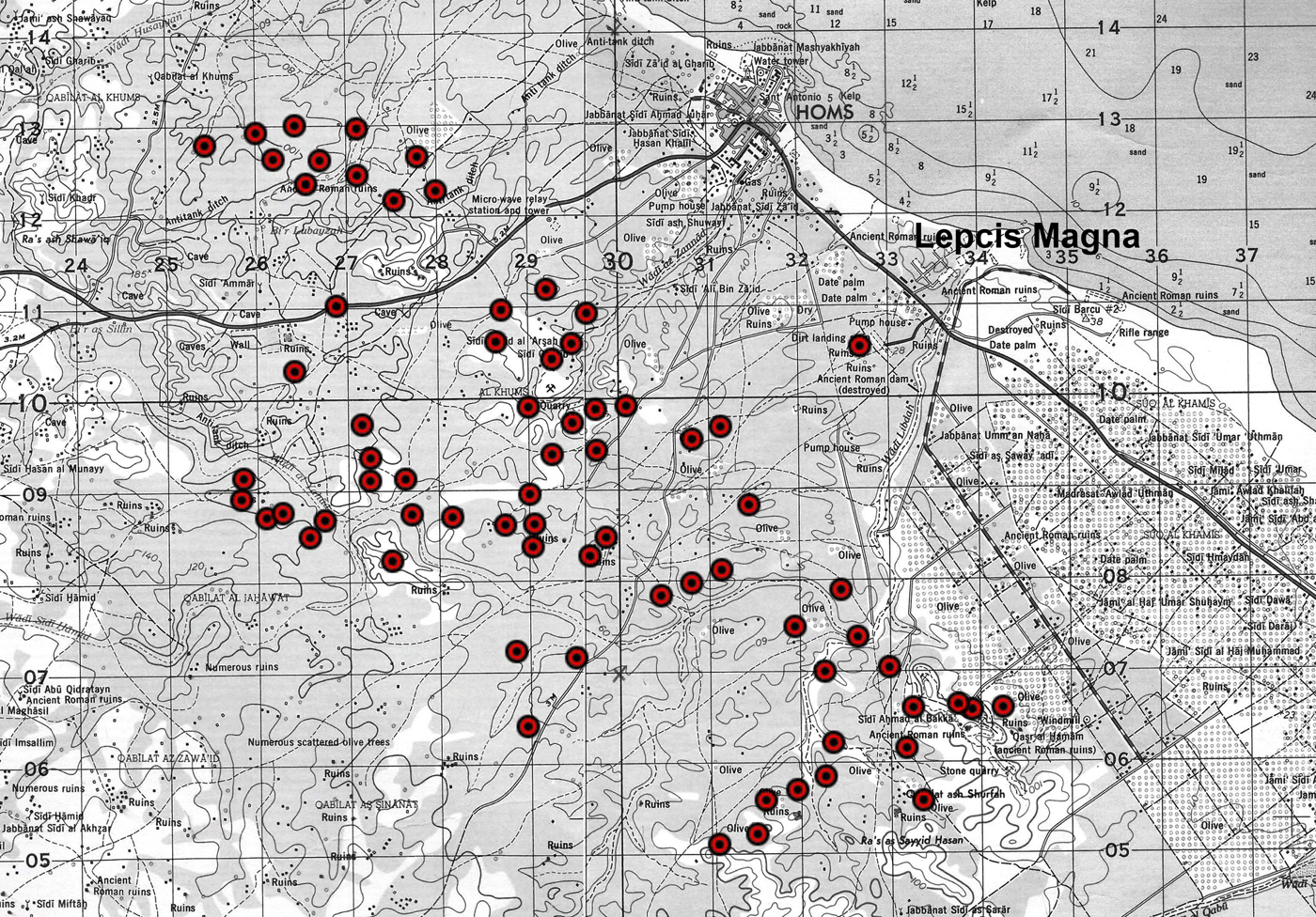
Figure 3. The Hellenistic phase: second century BC (background image: USACE 1962a–b). (Colour online.)
As already noted in other areas, the rural presence increased gradually between the first century BC and the second century AD, growing from 98 (first century BC) to 129/130 sites and related infrastructures (first to second century AD) following the political evolution which saw the entry of Lepcis Magna into the greater Roman region, and then its full political and economic integration into the imperial system (Figure 4).

Figure 4. The Roman Imperial phase: second century AD (background image: USACE 1962a–b). (Colour online.)
Also in the suburban fringe the landmarks during the first and mid-Imperial periods are farms and villae, the latter characterised by the provision of luxury furnishings, such as marble floors or mosaics, painted plaster, stucco, sometimes architectural decoration in limestone or marble (see part 2.2). They represent the evolution of the rural sites of the Numidian period, which by now, during the first two centuries AD, had spread everywhere. Rectangular or square in plan with a central courtyard, built in a masonry technique called opus africanum, they were systematically provided with facilities for olive oil and possibly wine production (Figure 5; see al-Hadad in Musso et al. Reference Musso, Baldoni, Baroni, Bessi, Bianchi, Bruno, Buccino, Davidde Petriaggi, Felici, al-Hadad, Munzi, Petriaggi, Shebani, Sjöström and Zocchi2013–14, 32). Often in the vicinity of the settlements, burial structures (mausolea) were erected, probably connected to the landowners (see part 2.5).
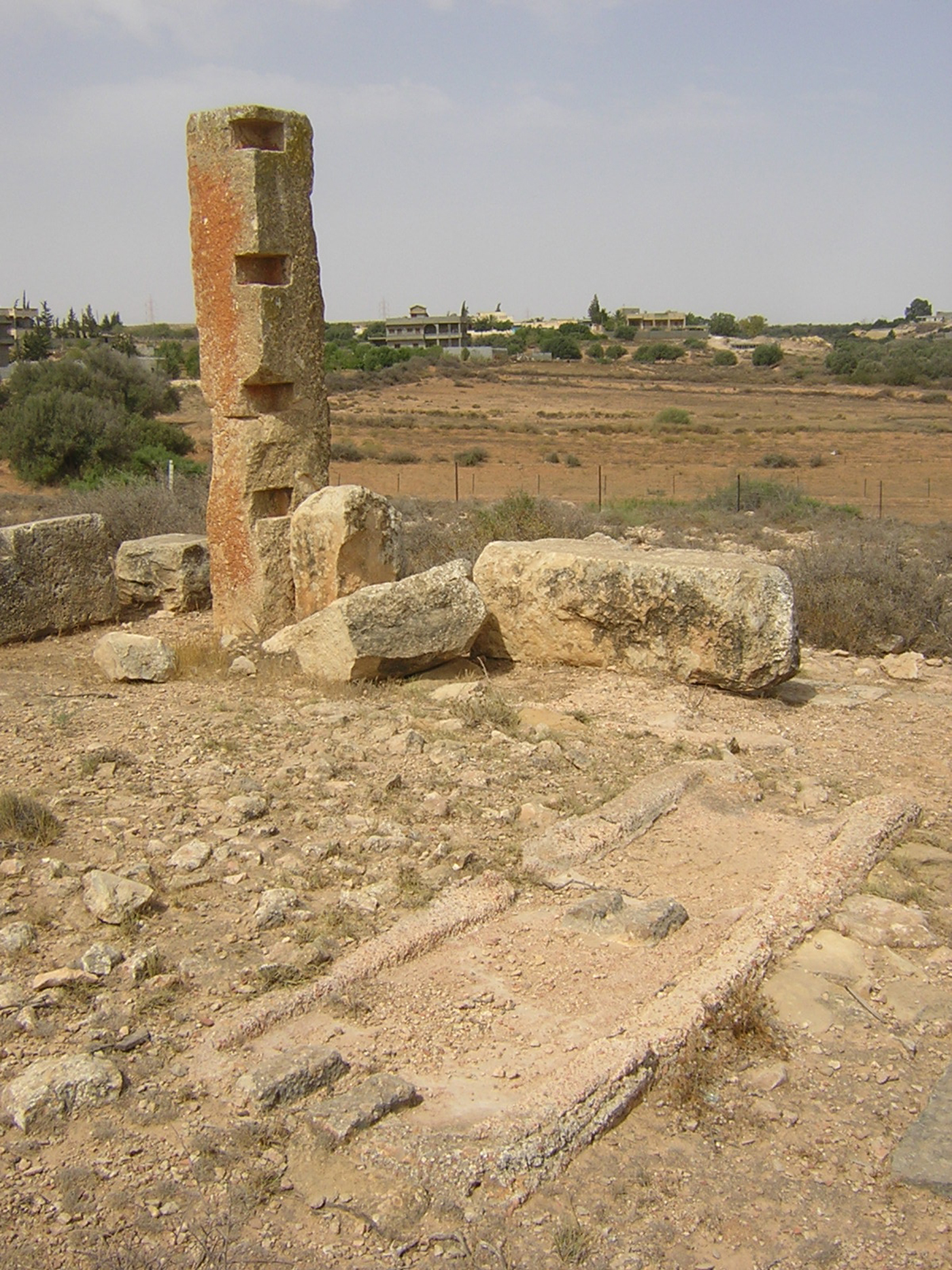
Figure 5. Remains of an ancient press at the farm KHM 87. Photo: Archaeological Mission Roma Tre University. (Colour online.)
However, what marked the suburban landscape was also an intense exploitation concerning the extraction of limestone (see part 2.4). Indeed, huge quarries have been identified and documented in the districts of the Zennad and es-Smara wadis and around the hill of Ras el-Hammam. Considering the relevance of some of them, an exploitation aimed at supplying the large urban building sites seems more than possible.
The Lepcitanian suburbs experienced a first phase of contraction during the third century AD, when the number of occupied sites decreased slightly (94 sites). The repercussions of the arresting of the large urban building programmes had to be suffered in the suburbs more than elsewhere, possibly causing quarry activities to stop or slow down.
A conjuncture of declining stability characterised the first Late Antique period – between the fourth century AD and the first half of the fifth – when the number of occupied sites dropped to 65–66. Numerous villae and open farms were turned into fortified farm buildings, with the consequent partial dismantling of torcularia (presses) and the reusing of their lithic elements in masonry (see part 2.2). According to some inscriptions, these buildings, usually equipped with strong walls and sometimes a defensive ditch, could be called turres (Reference Reynolds and Ward-Perkins IRT 876) or centenaria (Di Vita-Evrard Reference Di Vita-Evrard1991; Reference Reynolds and Ward-Perkins IRT 877–80). The term centenarium, traditionally considered a military term (a centenarius was an officer commanding a hundred men), was recently connected to centenum (rye); the derivation would be born in the African context as a synonym for horreum, its semantic value later evolved into that of a fort/fortified farm with a grain storehouse (see Adams Reference Adams2007, 550–54, 565, 571–72; Munzi et al. Reference Munzi, Schirru and Tantillo2014b; on the gsur of the Lepcitanian territory, Munzi et al. Reference Munzi, Felici, Sjöström and Zocchi2014a, 217–18, 220–23, and bibliography). The Arab conquerors later called this kind of building gasr (qasr ﻘﺼﺮ, plural qusūr or gsur), from the Latin word castrum (Shahid Reference Shahid2002, 67–75). Just as the pyrgoi of the Levant (Decker Reference Decker2006), the gsur had a dual function, both residential and defensive, being equipped to deal with low intensity dangers, such as nomadic raids.
The reuse of elements of torcularia in the masonry of some gsur seems to indicate a decrease in the number of infrastructures for olive oil production, but the survival of many of the open farms and villae had to ensure the continuation of agricultural activities, although at a slightly reduced scale. A recent survey of attestations of Tripolitanian amphorae in Italian contexts confirms that the Tripolitanian oil continued to be exported across the Mediterranean until at least the end of the fourth century AD (Ciotola and Munzi Reference Ciotola, Munzi, Cocco, Gavini and Ibba2012, 1417–20).
The real crisis of the ancient agricultural system came in the second half of the fifth century AD. In a significant chronological parallel with the fall of provincia Tripolitania to Vandal control, most of the settlements were abandoned, as indeed was documented through all of the other samples in our research. Similar trends have been registered in southern Tunisia (Kasserine and Djerba), while in the north the decrease does not appear before the late sixth century AD (Carthage, Dougga, Segermes) (see the discussion in Leone and Mattingly Reference Leone, Mattingly and Christie2004; see also Fenwick Reference Fenwick2013, 16–18).
For Tripolitania, unlike Zeugitana and Byzacena (Palmieri Reference Palmieri, Gonzales, Ruggeri, Vismara and Zucca2008), it is not possible to assume the Vandal age as being a positive conjuncture in continuity with the economic and productive system of the Imperial age. The intrinsic fragility of Tripolitania can be explained by its greater distance from the centre of the kingdom and consequent greater exposure to raids carried out by the Moorish tribes, who from their bases in the east and south-east of the province had gradually expanded their reach up to the walls of Lepcis Magna. The substantial contribution of the Vandal conquest to the deconstruction of the rural settlement and productive system of Tripolitania lies in having determined a crucial lack of authority and military defence, exposing the countryside to the hegemony of the tribes. The same suburbs would be seriously affected. According to Procopius (Aed. VI, 4, 6–9), Lepcis had become a deserted place after the Laguatan tribes, a few years before the Byzantine conquest, brought fire to what remained of the city (on the Austuriani and Laguatan: Felici et al. Reference Felici, Munzi, Tantillo, Akerraz, Ruggeri, Siraj and Vismara2006).
The Justinianic reconquest of Tripolitania, which occurred in AD 533, does not seem to have encouraged a recovery in settlement and agriculture. Neither the Tripolitanian cities, despite Justinian's revitalisation efforts, nor the Mediterranean market stimulated exploitation of the Tripolitanian countryside aimed at producing a surplus for selling. The number of rural settlements still in use in the sixth century AD (13 sites) had returned to the levels of third century BC (Figure 6). While sharing in general the assumption of David Mattingly (Reference Mattingly, Barker, Gilbertson, Jones and Mattingly1996, 342), who, referring to the pre-desert, warns against formulating a simplistic equivalence between the decline in the number of settlements and demographic collapse, we cannot escape from reading such a drastic contraction of sedentary human presence as a clear indicator of a marked crisis, not only economic but also demographic. It is likely that in this period the rural population, probably reduced in number, converted to pastoralism and semi-nomadism.

Figure 6. The sixth century AD phase (background image: USACE 1962a–b). (Colour online.)
The last sedentary survivals seem to have been extinguished during the seventh century AD, when just one or two sites still appear to have been frequented. As has been pointed out elsewhere, in the Lepcitanian territory, archaeological evidence of a settlement continuity between the Byzantine and the Arab age has been lacking. However, the 2013 survey helped to gradually bridge that documentary gap and, thanks to some numismatic finds, has returned the missing evidence of such continuity in the countryside: for the first time in a rural area, a Justinianic nummus, minted at Carthage in AD 533/34–37 (KHM 129), and two Umayyad fulus dating to AD 696/697–750 (KHM 140 and 146) have been discovered.
2.2 Farms, villae and gsur (F. F., I. S.)
The rural system was characterised by farms and villae rusticae that densely dotted the Lepcitanian landscape. They were usually built with opus africanum walls and equipped with one or more olive presses (see Figure 5), probably adaptable for wine production (see al-Hadad in Musso et al. Reference Musso, Baldoni, Baroni, Bessi, Bianchi, Bruno, Buccino, Davidde Petriaggi, Felici, al-Hadad, Munzi, Petriaggi, Shebani, Sjöström and Zocchi2013–14, 32). In the best-preserved examples, it is noticeable that the rooms are arranged around courtyards while the presence or absence of luxury elements such as painted plaster, mosaics, marbles or architectural decorations allows us to distinguish the farms from the villae. In some cases, the existence of a private bath has been recorded thanks to the presence of tubuli used in the interspaces and pools. A further distinctive element is the presence of one or two mausolea (see part 2.5). Overall, in this survey sample, 55 villae rusticae and 50 farms have been identified.
The fortified villa/farm (gasr, pl. gsur) was a common type of structure in the Late Antique period. In this survey sample, 24 gsur were documented. These gsur can be characterised by a quadrangular plan with a single entrance and usually an inner courtyard (for different types of these structures, see Mattingly et al. Reference Mattingly, Sterry and Leitch2013). They have been built using the opus quadratum technique, sometimes using smaller, regular stones; the reuse of ancient material was common. The nuclea of the walls, often very thick, are characterised by crushed stones mixed with poor lime. Sometimes the strong external wall of the structure is surrounded by an artificial defensive ditch. The sizes of these gsur vary from noticeable fortified complexes to small towers.
Below are described three significant gsur and the Ras el-Mergheb site. Two further structures (KHM 34, 87) were previously illustrated (G. Schingo in Munzi et al. Reference Munzi, Cirelli, Felici and Zocchi2010, 735–37). The fortified farm KHM 123, an opus quadratum structure encircled by a ditch, is set on the site of a former villa located on the middle of a hillside (Figure 7): numerous here are reused elements, such as an olive oil press tank and counterweight, and there are also different decorative architectural elements like a column base and column drums. Other structures such as a cocciopesto basin and a well are still visible in the area.
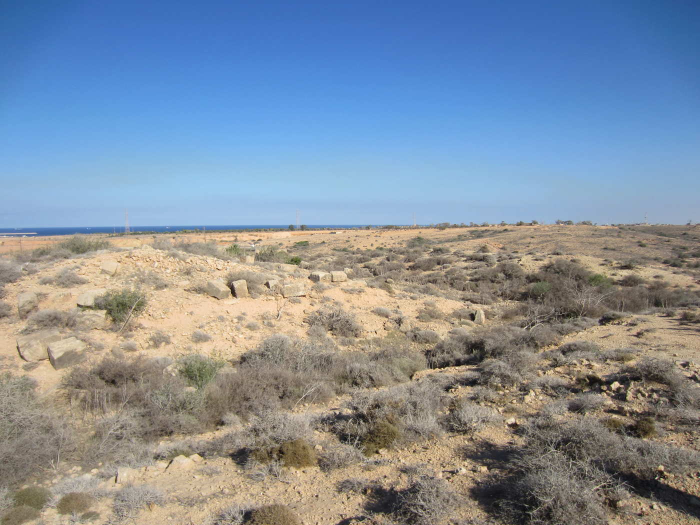
Figure 7. Remains of the gasr KHM 123 and its external ditch. Photo: Archaeological Mission Roma Tre University. (Colour online.)
Gasr KHM 125 is located on a hilltop 4 km west of Ras el-Mergheb (Figure 8): the external walls, built by reusing regular limestone ashlar blocks, are preserved for a maximum of four rows on the southern side. Below the gasr, a subterranean cistern was built by excavating the bedrock: it is characterised by double-vaulted rooms covered with cocciopesto plaster. On the ground near to the external walls of the gasr has been found a bracket peculiar to ecclesiastic structures, decorated on the front with a crux patens and with spirals on both sides.
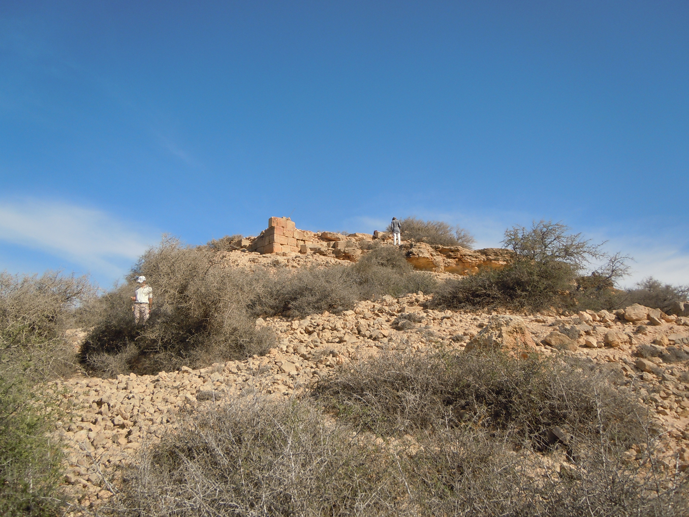
Figure 8. The gasr KHM 125 located on a hilltop, 4 km west of Ras el-Mergheb. Photo: Archaeological Mission Roma Tre University. (Colour online.)
Gasr KHM 130 is also located on a hilltop (Figure 9): it is characterised by a small mound of soil and rubble in which can be distinguished both the opus quadratum walls belonging to the external perimeter and the small limestone blocks used for the internal walls (c. 90 cm in thickness); different elements have been reused, such as a column drum and the vertical elements of a torcular. All around the external perimeter is a quadrangular ditch that has been excavated in the bedrock to a maximum width of 6 m.

Figure 9. The gasr KHM 130 with its quadrangular ditch (background image: Google Earth).
The ancient remains on the Mergheb hill (KHM 108) have rarely been visited by archaeologists for the simple reason that the hill has hosted military installations, not only in antiquity, but also during the Italo-Turkish war and thereafter, up until 2011. Before the visit by Munzi and Felici in June 2013, the best archaeological description had been given by Romanelli (Reference Romanelli1925, 168–70), partly based on previously published descriptions (Clermont-Ganneau Reference Clermont-Ganneau1903; de Mathuisieulx Reference Mathuisieulx1906) as by the time Romanelli visited the site it had already been considerably disturbed by the construction of Forte Italia in 1912. Two Latin inscriptions have been found at the site, Reference Reynolds and Ward-Perkins IRT 268 and 314 (see also Clermont-Ganneau Reference Clermont-Ganneau1903, 343–44).
At the top of the hill there is a platform with a vertical wall cut into the rock, facing south; in this wall (an ancient quarry face?) were various coarse niches used in the past by the local people to place offerings to the nearby marabout (shrine) of Sidna Ali, now vanished (Clermont-Ganneau Reference Clermont-Ganneau1903, 343–44). According to de Mathuisieulx (Reference Mathuisieulx1906, 76–77), the castellum Footnote 1 was built of ashlar blocks throughout and consisted of a metre-wide perimeter wall (22.5 × 14.6 m) that enclosed a rectangular keep (7.9 × 8.5 m; the maximum height of the walls in 1906 was 9 m) with a doorway 0.7 m wide and 1.7 m high. The main entrance to the enclosure was on the north-east, and that of the keep was on the same side. In 1906, the maximum height of the surviving external walls was no more than the ‘height of a man’ inside the circuit, but on the exterior they stood three metres high in places, making use of the height of the cliff (quarry) face.
Despite the NATO bombardments (or thanks to their precision) during the spring and summer of 2011, the beautiful arched gateway (3.41 m high and 1.98 m wide) still stands unscathed, constructed of well-cut limestone ashlar blocks, probably dating to the first century AD (Figure 10). This must have been the main entrance in the external wall circuit described by de Mathuisieulx, although it is difficult to make it conform absolutely to his plan; the keep has disappeared, replaced by the barracks of the Forte Italia.
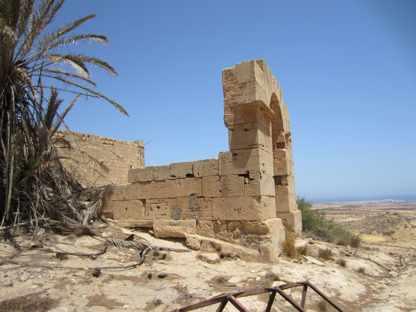
Figure 10. The arched doorway at Ras el-Mergheb (KHM 108). Photo: Archaeological Mission Roma Tre University. (Colour online.)
2.3 Olive presses (F. F.)
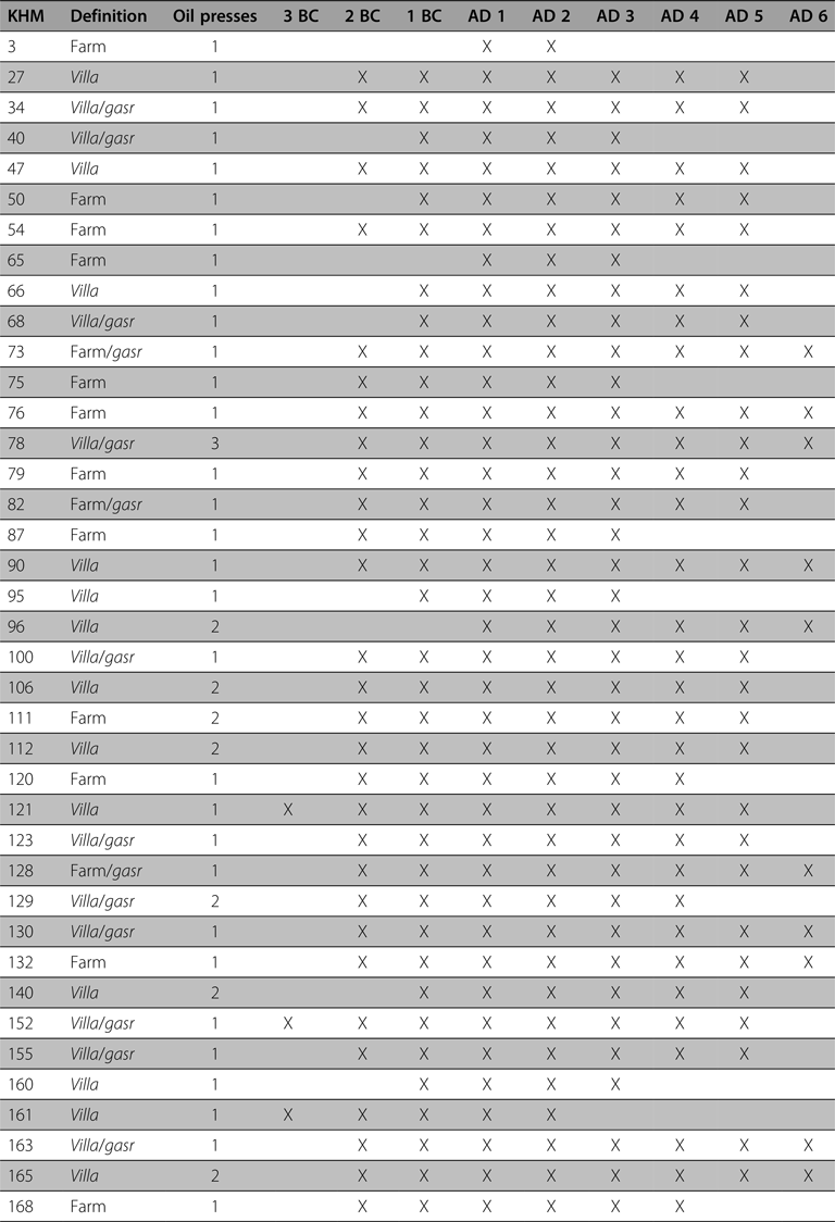
Like in others areas in the Lepcitanian territory, the survey sample between Ras el-Mergheb and Ras el-Hammam recorded direct evidence of an intensive olive oil production, attested in 39 sites, of which 24 were villae and 15 were farms. In the majority of these sites is registered at least one torcular, in eight sites two presses are in evidence, while in KHM 78 three torcularia have been documented (Table 3).
Table 3 Quantity and chronology of the olive oil/wine presses.
The Tripolitanian olive oil exportation constitutes a significant percentage, but not the most important one considering the whole production of the western Mediterranean area in the Imperial era. However, the peak of this phenomenon is registered in the Severan age; the direct implication of the Lepcitanian elite in olive oil production is indeed attested by the amphora stamps, especially widespread in this region during this period (Cordovana Reference Cordovana1999; Di Vita-Evrard Reference Di Vita-Evrard1983; Manacorda Reference Manacorda1976–77; Reference Manacorda, Blàzquez Martinez and Rodriquez1983). From the third century AD onwards is documented a contraction in production; this reduction is also recorded by the literary sources who mention the difficulties of the local communities to be faithful to the praebitio olei, exempted only by Constantine (Aur. Vict., Caes. 41, 19; Di Vita-Evrard Reference Di Vita-Evrard, Buck and Mattingly1985). The standard Tripolitanian amphorae exportation in the Mediterranean basin ended in the first half of the fifth century AD, when olive oil production, in constant contraction, seems to have mostly reached the local and regional markets and only minimally the western Mediterranean regions, however with new types of amphorae (Ciotola and Munzi Reference Ciotola, Munzi, Cocco, Gavini and Ibba2012, 1417–19).
2.4 The limestone quarries (A. Z.)
The area between Ras el-Mergheb and Ras el-Hammam is located behind the coastal strip (about 4 km wide) and is characterised by a hilly landscape with different wadis that run sinuously from inland towards the coastline. These seasonal streams (the Chadrun, Zennad and Lebda wadis, the last with its main tributary of es-Smara) eroded the soil forming valleys whose sides often show the exposed bedrock. Along these wadis and among the Ras el-Hammam hills, 17 local stone ancient quarrying activities were recognised between 2007 and 2013 (Figure 11). In the Lepcis Magna area, the large use of local stone in Roman times is attested since the early Imperial period and, to date, different quarries have been described and various qualities of stone have been analysed (Bruno and Bianchi Reference Bruno, Bianchi, Pensabene and Gasparini2015; Chiesa Reference Chiesa1949; S. Franchi in MC 1913, I, 61–64). Moreover, in-depth studies concerning architectural decoration in local stone have recently been written (Bianchi Reference Bianchi2005; Mahler Reference Mahler2006). However, a general topographic overview of the quarries in the Lepcitanian inland has never been outlined to properly consider the exploitation of local stones, both for the Lepcis building activities and for its suburban needs.

Figure 11. The quarries of the Lepcitanian hinterland and the main wadis (background image: Google Earth). (Colour online.)
All of the sites recorded by our surveys can be divided into three main districts: the Wadi es-Smara district, the Wadi Zennad district and the Ras el-Hammam district, plus an isolated quarry at the foot of Wadi Chadrun (KHM 118) and two sites behind the Ras el-Hammam area (KHM 156, 167). These three different districts furnished different qualities of stone described briefly by Cesare Chiesa (Reference Chiesa1949, 25–26) in the mid-twentieth century and recently reaffirmed by M. Bruno and F. Bianchi (Reference Bruno, Bianchi, Pensabene and Gasparini2015, 36, 40). A further ancient quarry district probably characterised the Ras el-Mergheb area (see part 2.2); unfortunately, to date, it has not been possible to survey with accuracy the slopes of the hill.
The evolution of limestone quarries through the Roman Imperial phases has recently been outlined and connected to the Lepcitanian building programme, especially to the Severan complexes (Bruno and Bianchi Reference Bruno, Bianchi, Pensabene and Gasparini2015, 40–42). Observing the different quarry faces and their exploitation, it is plausible to identify the quarries related to the city's major building programmes. The Ras el-Hammam district comprises, after the exploitation of the quarry near the amphitheatre, the first important supply basin, especially with its large sites at KHM 138, 139 and also at KHM 142. Their quarry faces at a height of about 10 m suggest an intensive exploitation and a highly efficient organisation. Moreover, the site KHM 18 of the Wadi Zennad district, 200 m in length and approximately 8 m in height, could constitute a propitious quarry that provided limestone in large quantities. The big district of Wadi es-Smara was one of the most exploited for the Lepcis Severan buildings needs. The quarry faces of this district, belonging mainly to the Ras el-Gatatsa massif south and north of the wadi (KHM 59–60 and KHM 61, 80), prove an intense and extended quarrying activity organised in different stages (Bruno and Bianchi Reference Bruno, Bianchi, Pensabene and Gasparini2015, 41). The other quarry faces surveyed in the territory belonging to these three districts could, of course, have supported the main ones, furnished different stone elements or provided for, together with the other sites, the suburban and inland needs.
However, the transportation of the material from the quarries within the city would have been a significant effort. The Wadi Zennad quarry (KHM 18) could easily have used the wadi bed to reach the coastal plain and, from there, turn into the via in mediterraneum on the right or the coastal road to the north, or use a proper path used for quarrying needs (for the road system see IRT, map 6). A similar situation could be hypothesised for the Ras el-Hammam district, where slipways should exist in the northern side of the hill (probably to the north of KHM 138). From the coastal plain, the best solution in this case would have been to reach the main coastal road and then cross Wadi Lebda using the same route as the road. The existence of a slipway and of some limestone ashlar blocks along the bed of Wadi es-Smara seems to prove that the Ras el-Gatatsa quarries (KHM 59–61, 80) used the wadi to transport their materials to the city. However, the presence of an opus caementicium structure probably related to a dam located shortly before the junction of Wadi es-Snanat and Wadi es-Smara (site KHM 97) could suggest that the preferred route used was, from a certain sector onwards, the via in mediterraneum. If we consider it acceptable to date this hydraulic structure to between the second half of the first century AD and the first half of the second, as the main dam along Wadi Lebda is dated (Pucci et al. Reference Pucci, Pantosti, De Martini, Smedile, Munzi, Cirelli, Pentiricci and Musso2011, 183), it is then plausible to hypothesise quite easily the route used by the workers to transport the limestone elements to Lepcis Magna. Indeed, the quarried material from the Wadi es-Smara district had to use, for a first sector, the wadi bed and then, due to the blockage of the dam crossing the valley, it had to continue northwards using the main road in mediterraneum that should cross the wadi somewhere before or around the barrage and lead directly into the city.
2.4.1 The Wadi Zennad district (KHM 12, 18)
The Wadi Zennad district is the smallest when compared with the Wadi es-Smara and Ras el-Hammam districts. Nevertheless, even if Chiesa (Reference Chiesa1949, 26) was not able to locate the Wadi Zennad quarries with accuracy, he did manage to roughly distinguish the quality of its limestone from those of Ras el-Hammam. However, the main quarry of this district (KHM 18) was already mentioned and recognised as ancient by the Commissione per lo studio agrologico della Tripolitania that surveyed this area at the beginning of the last century (S. Franchi in MC 1913, I, 64). The Wadi Zennad district is characterised by two different sites (Figure 11). Site KHM 12 (briefly mentioned in Munzi et al. Reference Munzi, Felici, Cirelli, Schingo, Zocchi, Milanese, Ruggeri and Vismara2010, 727) is located on the south-west flank of a hill at the beginning of the northern branch of Wadi Zennad. It has a quarry face more than 40 m long divided into two different sectors that reach 6 m in height (Figure 12). Site KHM 18 is located on the south-east flank of the hill facing the southern branch of Wadi Zennad at the junction with Wadi Seccum (Figure 13). The quarry reaches almost 200 m in length and a maximum height of c. 8 m, and is characterised by vertical facades and by wide steps. Huge regular blocks are still visible towards the valleys of the wadis, laid between the wide steps and piles of debris.

Figure 12. Wadi Zennad district: the quarry face at KHM 12. Photo: Archaeological Mission Roma Tre University. (Colour online.)

Figure 13. Wadi Zennad district: the quarry face at KHM 18. Photo: Archaeological Mission Roma Tre University. (Colour online.)
2.4.2 The Wadi es-Smara district (KHM 59–61, 77, 80, 84, 89)
Wadi es-Smara is the main left tributary of Wadi Lebda and, thanks to the el-Belaari and es-Snanat (or el-Uaara) wadis, and other minor streams, it constitutes the main seasonal hydrographic basin of the Lepcitanian suburban territory (Figure 11). Bruno and Bianchi (Reference Bruno, Bianchi, Pensabene and Gasparini2015) recognised part of the quarries along this stream as the ‘Wadi Gadatza district’. However, the term Gadatza referring to the wadi has never been cited in historical or recent cartography, which instead mention the ‘hydronym’ of Wadi es-Smara (IGM 1915; 1918; 1937; USACE 1953). On the contrary, the cartography records instead a ‘Ras el-Gatatsa’, a hill located in the area among the sites KHM 59–61 and 80 (sectors I–VII in Bruno and Bianchi Reference Bruno, Bianchi, Pensabene and Gasparini2015).
This district is characterised by seven different sites located on different hills along Wadi es-Smara and at the confluence of this wadi with Wadi el-Belaazi (Figure 11). The first mention of some of these quarries comes from the report made by the Commissione per lo studio agrologico della Tripolitania, in which are reported ancient Roman quarries along the south side of Wadi es-Smara between the Ras Cohla/Kókla hill (KHM 89) and the junction with Wadi Lebda (S. Franchi in MAIC 1912, 40; MC 1913, I, 62).
The main quarry faces of the district are those of the site KHM 61 (see also Bruno and Bianchi Reference Bruno, Bianchi, Pensabene and Gasparini2015, sectors I–II, IV–V, 36–39). The site is characterised by three different quarries located on the northern, eastern and southern flanks of the hill that, according to the IGM map (1937), should be named Ras el-Gatatsa. The quarry on the north side, facing Wadi es-Smara, has been partially exploited in recent years (Figure 14), but there are still traces of ancient quarrying with pick marks and wedge holes and also a slipway that leads to the valley of the wadi, where different ashlar blocks are still visible (Bruno and Bianchi Reference Bruno, Bianchi, Pensabene and Gasparini2015, sectors I–II, 36–38). On the east side of the same hill and facing the wadi, there is another quarry divided into three sections with numerous regular limestone blocks waiting to be carried away (Bruno and Bianchi Reference Bruno, Bianchi, Pensabene and Gasparini2015, sector V, 39). The last quarry of site KHM 61 is located on the southern part of the hill, though it looks north towards a saddle between two crests. This quarry face is one of the longest, approximately 200 m in extent and about 5 m in height; at the foot of the quarry, partially buried by debris, there are two dragon houses probably used by the quarry workers (Bruno and Bianchi Reference Bruno, Bianchi, Pensabene and Gasparini2015, sector IV, 38–39). On the western flank of the hill, on the east side of Wadi el-Belaari, different quarry faces are still visible (KHM 80; see also Bruno and Bianchi Reference Bruno, Bianchi, Pensabene and Gasparini2015, sector III, 38). On the eastern flank of this part of the hill there are still in situ, on a flat yard, dozens of parallelepipedal blocks arranged in parallel lines waiting to be carried away.
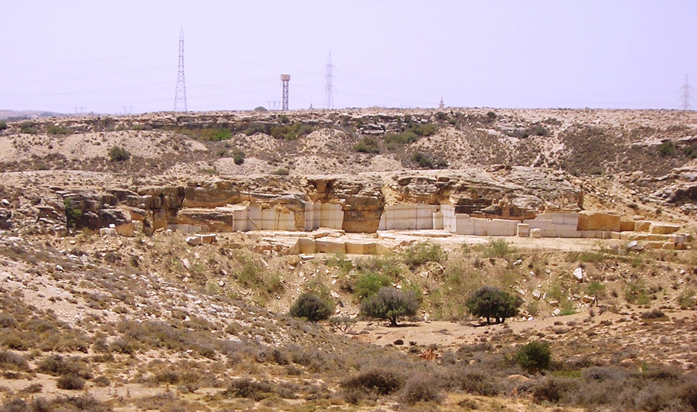
Figure 14. Wadi es-Smara district: the ancient and modern quarry face (north side) at KHM 61. Photo: Archaeological Mission Roma Tre University. (Colour online.)
Site KHM 60 is located on a hill to the north of Wadi es-Smara, in fact the one named Ras el-Gatatsa by the Italian maps (IGM 1915; 1918). The site has the longest quarry face of the Wadi es-Smara district, approximately 300 m in extent and reaching 10 m in height. On the hilltop and at the foot of the quarry face there are many large debris piles and also numerous parallelepipedal blocks lying on the ground (Bruno and Bianchi Reference Bruno, Bianchi, Pensabene and Gasparini2015, sector VI, 39–40).
Two hundred metres west of KHM 60, another hill, site KHM 59, preserves on its head another quarry face (c. 100 m long and 3.5 m high) with a non-linear pattern and with many debris piles at its base (Bruno and Bianchi Reference Bruno, Bianchi, Pensabene and Gasparini2015, sector VII, 40).
At a short distance, after the confluence of Wadi el-Belaari with Wadi es-Smara, is located another important quarry face (KHM 77), c. 50 m long with a maximum height of 8 m (Figure 15). This quarry face is characterised by different wide steps and debris piles at its foot. On the bedrock, still visible are ancient tool marks such as the chisel and the pick. On the opposite side of the wadi, another quarry face is visible on a hilltop (KHM 84); in this case, the bedrock exploitation involved all of the upper east side of this hill for more than 50 m in length and 5 m in height. The last quarry of the Wadi es-Smara district (KHM 89) is located in the north-western part of the watercourse valley, on the west side of the Ras Cohla/Kókla hill. The quarry face is irregular with a segmented plan; it is c. 40 m long and its maximum height is c. 3.5 m (Figure 16).
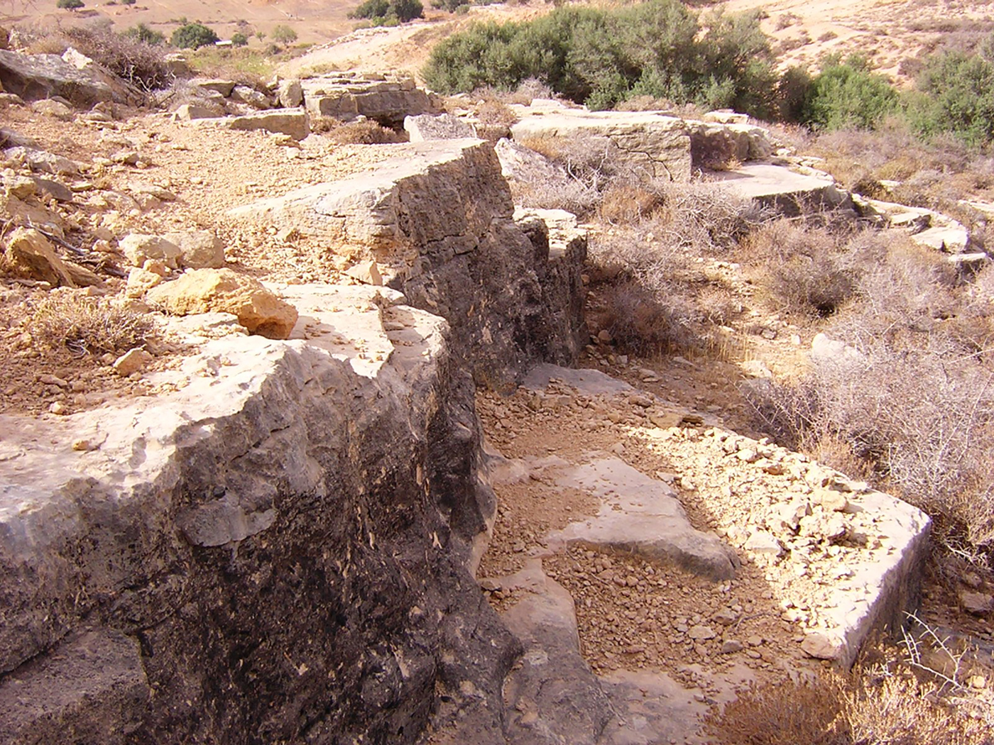
Figure 15. Wadi es-Smara district: the quarry face at KHM 77. Photo: Archaeological Mission Roma Tre University. (Colour online.)

Figure 16. Wadi es-Smara district: the quarry face at KHM 89. Photo: Archaeological Mission Roma Tre University. (Colour online.)
2.4.3 The Ras el-Hammam district (KHM 138–39, 142–43, 145)
The Ras el-Hammam district, among all the quarried areas of the Lepcitanian territory, is the most well known (recently, A. Zocchi in Musso et al. Reference Musso, Baldoni, Baroni, Bessi, Bianchi, Bruno, Buccino, Davidde Petriaggi, Felici, al-Hadad, Munzi, Petriaggi, Shebani, Sjöström and Zocchi2013–14, 36) and, together with the Wadi es-Smara district, is the largest one (Figure 11). These quarries were mentioned for the first time by Pierre Girard of Seyne in 1670, quoted by Romanelli (Reference Romanelli1925, 56) as saying: ‘Et vers le midy à une petite lieue de la ville s'eleve une colline, où sont le carrieres du beau marbre blanc, dont Leptis estoit presque toute bastie.’
Different qualities of limestone characterised these quarries that were widely exploited, especially during the first and second centuries AD (Bianchi Reference Bianchi2005, 190; Chiesa Reference Chiesa1949, 25–26; Ward-Perkins Reference Ward-Perkins1993, 90). The quarrying activity involved all flanks of the hill but the north-east side was more exploited than the others. The main quarry face (KHM 138) is preserved at c. 400 m in length and a maximum height of c. 10 m (Figure 17). The majority of these quarry face sectors retain a vertical facade without steps while the inner north-west part of the site seems to have been partially exploited underground, probably seeking better quality bedrock. Different tool marks are visible along the quarry face and, at the foot of the bedrock exploited there, are still visible different mounds of debris that in part also cover the quarry face; several blocks, often partially worked, lie on the ground. Towards the north, two large trails that lead to the coastal plain may trace ancient slipways. Two hundred metres south-east of site KHM 138, another ancient quarry face (KHM 139), c. 200 m long, is clearly visible and, similar to the previous one, it has a maximum height of c. 10 m.
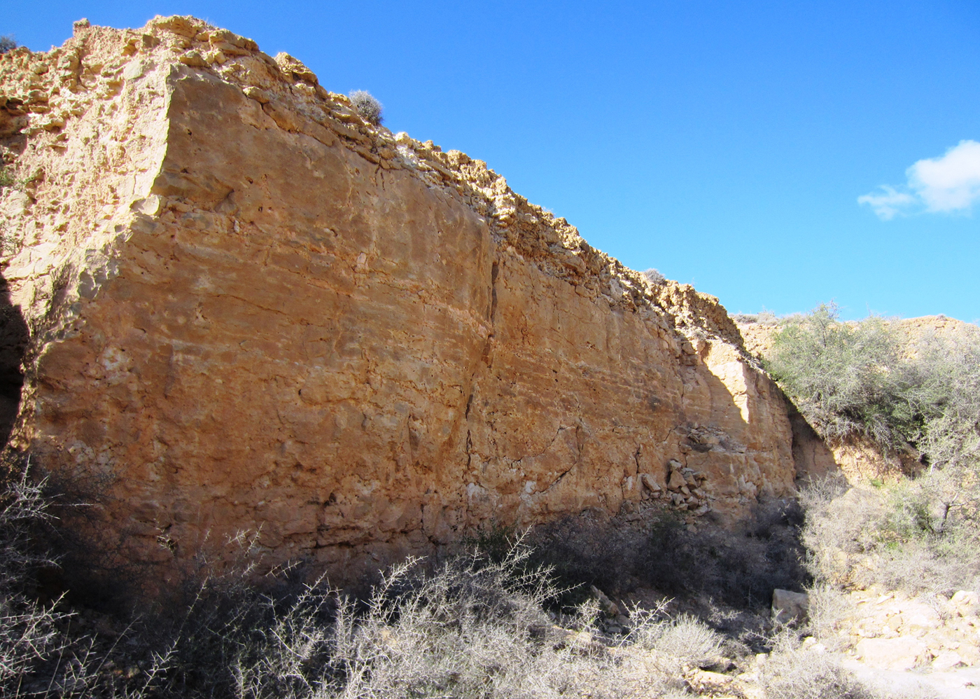
Figure 17. Ras el-Hammam district: part of the quarry face at KHM 138. Photo: Archaeological Mission Roma Tre University. (Colour online.)
The southern flank of Ras el-Hammam is less exploited compared with its north side. A quarry face is visible on the eastern part of the hill, facing inland (KHM 142); the sector of the exploited bedrock is c. 150 m long and it is preserved at a medium height of c. 3.5 m (Figure 18). Next to the western part of the site, beside different debris mounds at the foot of the quarry face, four big similar parallelepipedal blocks lie on the ground, of which the largest measures 1.54 × 1.10 × 0.85 m. In the western part of the hill's southern flank, another quarry face is preserved (KHM 143) at c. 150 m in length and 3–4 m in height (Figure 19). Along the steps of this quarry, still noticeable are wedge holes, chisel marks and narrow trenches made in the bedrock to separate and extract different blocks. The last quarry of the Ras el-Hammam district is located at the western edge of the hill (KHM 145), facing partially to the north and partly to the south. The quarry face of this site is irregular and often characterised by different steps.
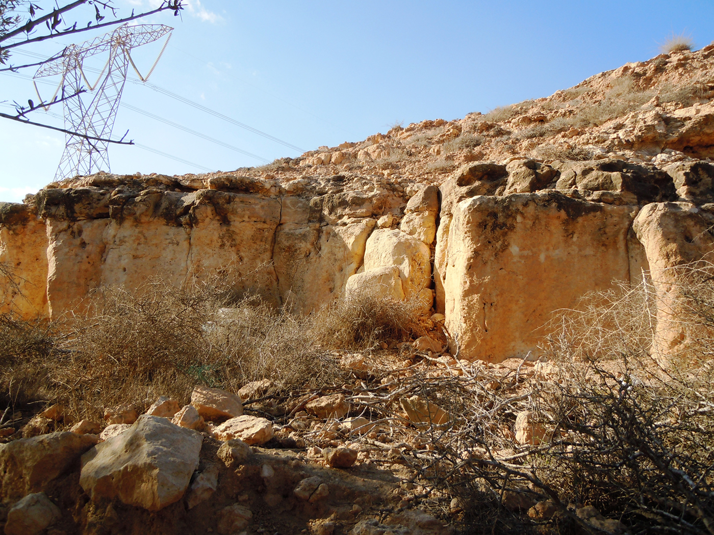
Figure 18. Ras el-Hammam district: part of the quarry face at KHM 142. Photo: Archaeological Mission Roma Tre University. (Colour online.)
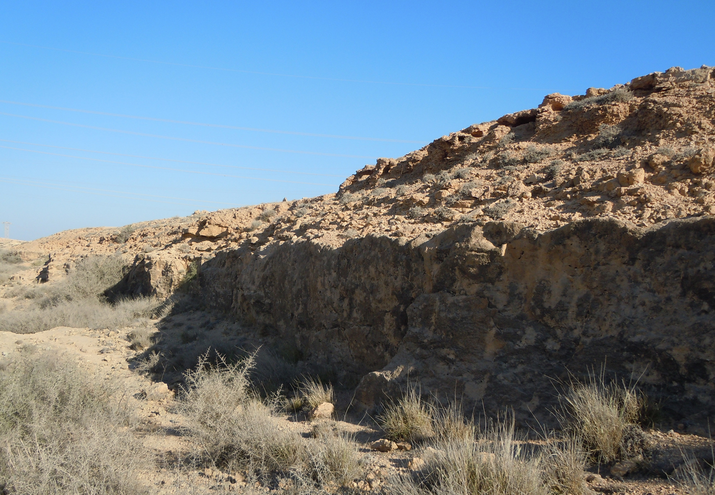
Figure 19. Ras el-Hammam district: the quarry face at KHM 143. Photo: Archaeological Mission Roma Tre University. (Colour online.)
2.4.4 Isolated quarries (KHM 118, 156, 167)
Approximately 1.5 km south of the Ras el-Hammam district, a long and shallow quarry face (KHM 156) is visible on the southern flank of a low hill (Figure 11). The quarry extension, more than 700 m long with a maximum height of 2 m, is characterised by mostly short, low steps partially ruined by the erosion (Figure 20). The quarry seems to have exploited almost all of the superior surface of the bedrock and, along the steps, traces of the working phases are still visible, such as the separation cuts made with wedges to extract the stones.

Figure 20. Partial view of the quarry face at KHM 156. Photo: Archaeological Mission Roma Tre University. (Colour online.)
Site KHM 167 is located on a hill about 3 km south-west of Ras el-Hammam (Figure 11). This quarry is characterised by different sections, of which the longest is visible on the western flank of the hill where it reaches a length of c. 250 m and a height of c. 3 m. The quarry face is irregular and characterised by different steps and large piles of debris at its foot. On the eastern border of the same hill, other smaller quarry faces are still recognisable; on the bedrock of this area, there are evident traces of the extraction of the limestone blocks made with wedges (Figure 21).
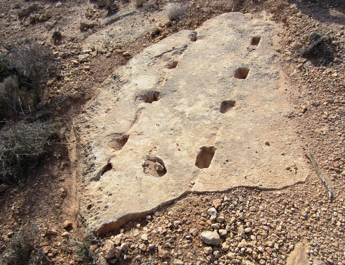
Figure 21. Ancient tool marks on the bedrock of the quarry at KHM 167. Photo: Archaeological Mission Roma Tre University. (Colour online.)
A little quarry (KHM 118), less than 50 m in length, was identified near the beginning of Wadi Chadrun, c. 1.2 km north-west of Ras el-Mergheb (Figure 11). This quarry face has a total height of 2.5 m and it is characterised by five steps on which are still visible traces of chisels and picks (Figure 22).

Figure 22. The quarry face at KHM 118. Photo: Archaeological Mission Roma Tre University. (Colour online.)
2.5 The Roman funerary landscape (A. Z.)
The survey of the Lepcitanian hinterland has revealed the presence of different structures related to the Roman burial customs (Figure 23). Between 2007 and 2013, 11 mausolea and two hypogean tombs were identified. The first hypogeum (Figure 23, KHM 70) is the well-known Gelda's tomb, dated to the Flavian period (Di Vita-Evrard et al. Reference Di Vita-Evrard, Fontana, Mallegni, Munzi and Musso1996); the other (Figure 23, KHM 154), whose interior was not explored because it was filled with rubble and soil, was detected just west of Ras el-Hammam, near the confluence of Wadi es-Smara with Wadi Lebda. Unfortunately, contrary to what has been found at Lepcis Magna and its closer suburbs (De Miro and Fiorentini Reference De Miro and Fiorentini1977; Fontana Reference Fontana1996a, 81), no funerary traces related to the pre-Roman phases have been found.

Figure 23. The Roman funerary landscape of the Lepcis Magna hinterland (background image: USACE 1962a–b).
The area surveyed is part of the rich Lepcitanian rural hinterland and, in terms of funerary landscape, it appears different from what has been recognised, if only in limited areas, in the suburban fringe (for the suburbs, see Fontana Reference Fontana1996a; Reference Fontana, Keay and Terrenato2001; Romanelli Reference Romanelli1925, 157–67). Indeed, the organised and dense necropolis found in both the east and the west sectors of the Lepcis suburb seem to give way to a different funerary scenery, characterised essentially by isolated mausolea. The topographic position recorded for many of these structures (KHM 2, 10, 35, 106, 136, 146), similar to what has been noticed in the Segermes Survey Project, would suggest that they were built on the top of or on the slopes of hills, dominating, therefore, the surrounding land (Moore Reference Moore, Stone and Stirling2007, 89). Other mausolea located on a plain landscape could instead take advantage, in terms of visibility, of their height (KHM 68, 107) or the nearness of roads (KHM 103). For Gasr Gelda (KHM 103) and for the Flavian hypogean tomb (KHM 70) the via in mediterraneum that leads from Lepcis Magna towards the south-west should in fact serve as a perfect stage. In addition, for the three mausolea (KHM 2, 10, 35) located between Lepcis and the ancient site of the Ras el-Mergheb (KHM 108, see part 3.2), it is plausible to hypothesise their vicinity to an ancient road that has not been identified, but should, however, exist in the same area to allow a connection between the city and the Mergheb hill. Moreover, some of these funerary structures (i.e. KHM 104, 106, 107, 136 and 146) were linked to rural properties. The connection of power and economic means to landholdings seems to have been a common factor of the Lepcitanian territory, as much as the landowners’ will to build mausolea in their countryside properties rather than in the city surroundings (for these aspects, see Bentivogli Reference Bentivogli, Khanussi, Ruggeri and Vismara2004; Moore Reference Moore, Stone and Stirling2007, 89–90).
Almost all of the 11 mausolea recorded during the survey seem to belong to the tower-mausoleum type (Clauss Reference Clauss, Moretti and Tardy2006; von Hesberg Reference Hesberg1994, 144–84), or to the ‘tombeaux à édicule sur podium’ (Gros Reference Gros, Editions and Picard2001, 399–422). As in the ancient Tunisian landscape (Moore Reference Moore, Stone and Stirling2007, 84–87), these two types of mausolea seem, therefore, to be well represented in the Lepcis Magna peri-urban territory. For two other funerary structures, a different architectural typology may be proposed. For Gasr Legbeba (KHM 104), both its cubic volume and the absence of a second storey suggest that it could belong to the ‘dice mausoleum’ type. Whereas, though the architectural elements are very scarce, the largest of the two mausolea at the north-east flank of Ras el-Hammam (KHM 106) should instead belong to the temple-mausoleum type (for these funerary structures, see in general Gros Reference Gros, Editions and Picard2001, 444–52; von Hesberg Reference Hesberg1994, 209–30).
2.5.1 Gasr Gelda / el-Gelêdah (KHM 103)
The closest mausoleum to Lepcis Magna recorded by our survey is the one known as Gasr Gelda or Gasr el-Gelêdah (Figure 23, KHM 103). The structure, located c. 2 km south-west of the Severan arch of Lepcis, is actually situated inside a private property. Unfortunately, few remains of its original structure are still visible (Figure 24), mainly due to the damages caused by the Italo-Arab conflict in the years between 1915 and 1925 (Munzi et al. Reference Munzi, Cirelli, Felici and Zocchi2013, 27–28, fig. 18). However, thanks to old photographs (see Figure 25) and to the description made by Pietro Romanelli (Reference Romanelli1925, 165 and fig. 91), it is possible to hypothesise over its original aspect. The mausoleum, built wholly in limestone ashlar blocks, has a plan (still measurable at the base) of 5.9 × 5.5 m and it was characterised by two storeys. The lower one, actually preserved to a maximum height of c. 1.5 m, originally measured c. 2.5–3 m while the second storey was characterised by 12 rows of limestone blocks to a total height of c. 6 m. Apart from the moulded base and the cornice of the two storeys, there were no traces of further decoration in situ. Romanelli, however, saw different architectural elements on the ground such as acroteria (defined by palmette and spirals) and part of a Doric frieze, probably similar to others already stored at the Lepcis Magna Museum (Mahler Reference Mahler2006, 815f–817f; Romanelli Reference Romanelli1925, 165; von Hesberg Reference Hesberg, Kreikenbom, Mahler and Weber2005, 51 and fig. 3). These decorations and elements may help to suggest the original entablature and roof. The facade should indeed be characterised by four columns like a prostyle temple.
Figure 24. The Gasr Gelda mausoleum (KHM 103). Photo: Archaeological Mission Roma Tre University. (Colour online.)

Figure 25. The Gasr Gelda mausoleum (KHM 103). Photo: A. Alemanni, 1911–12.
About 2 m from the facade of the structure and in a central position is still visible the limestone moulded epystil (2.06 × 0.90 m) related to the entrance of the subterranean chamber, unfortunately covered by soil. Moreover, at the foot of the mausoleum, Romanelli saw an inscription (Reference Reynolds and Ward-Perkins IRT 745) with mention of a member of the ‘Tapapi’ family written on an unframed limestone ashlar block, which could be pertinent to the lower storey of the facade. Considering the Doric frieze and the inscription, it seems possible to date the mausoleum to between the second half of the first century AD and the beginning of the second (for the inscription, see Fontana Reference Fontana1996a, 81; 2001, 166; for the frieze, see Mahler Reference Mahler2006, 815f–817f).
2.5.2 Gasr ed-Dueirat (KHM 68)
Approximately 1 km west of Gasr Gelda and 2.5 km south-west of Lepcis Magna are located a Roman farm/villa and the platform of the mausoleum known as Gasr ed-Dueirat (Figure 23, KHM 68). Many scholars of the first half of the last century were able to see its podium and describe its main architectural elements before they were moved to the Lepcis Museum.Footnote 2 The structure was reconstructed between 2001 and 2009 by the Mission archéologique française en Lybie in the garden of the Archaeological Museum of Lepcis Magna (Michel Reference Michel and Ensoli2012, 101) and it was reassembled as a two-storey mausoleum (Figure 26). More recently, its structural, architectural and decorative features have been studied in depth by Jacques Vérité (Reference Vérité2014), who has partially reconsidered the restoration (Figure 27) and has proposed an interpretation that links some decorative elements to Mithraism (Vérité Reference Vérité2014, 31–33).
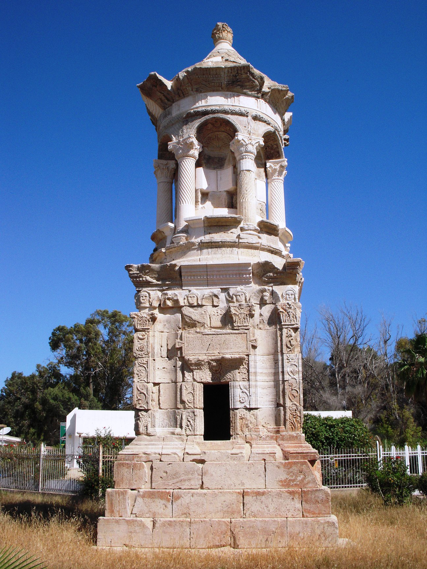
Figure 26. The Gasr ed-Dueirat mausoleum (KHM 68) reassembled in the Lepcis Magna Museum garden. Photo: Archaeological Mission Roma Tre University. (Colour online.)

Figure 27. Elevation of the Gasr ed-Dueirat mausoleum (KHM 68). Vérité Reference Vérité2014, fig. 10.
The mausoleum is built on a crepidoma formed by three steps, while the podium, with its almost square plan (4.62 × 4.42 m), is c. 3.5 m high and is richly decorated (for a detailed description of the decoration, see Vérité Reference Vérité2014). The second storey is characterised by an aedicula with six niches and six tortile columns linked together through arches. In these niches had to be accommodated the statues of the six characters mentioned in the inscription (Reference Reynolds and Ward-Perkins IRT 729) of the podium. Above the arches is a Doric frieze composed of 14 metopes and triglyphs. On two of these metopes were carved the personification of the Sun and of the Moon (Romanelli Reference Romanelli1925, 166, figs 95–96) and on the other 12 the signs of the zodiac. Actually, still preserved are the signs of Cancer, Leo, Scorpio, Sagittarius and, partially, Pisces. The upper cornice is characterised at the four oriented corners by the personification of the Seasons, all preserved except for Spring. The covering of the mausoleum was conical with smooth imbrications.
Owing to the composite decorative and architectural plan of the structure, and the serious attention to its details, Gasr ed-Dueirat can be considered one of the most impressive mausolea of the Tripolitanian landscape. The flow of time metaphor, underlined by the cosmological decorative programme with the signs of the zodiac, the Sun and the Moon metopes, and the cornice with the four Seasons give to the structure unique peculiarities. The recent analysis made by Jacques Vérité (Reference Vérité2014, 23–31) on the decorative elements and on the general pattern suggest that the mausoleum dates to the Severan age. However, both its epigraphic elements (such as the lack of the diis manibus formula and the presence of the gentilicium ‘Marius’ from the African Proconsul Marius Priscus – AD 98/99) and its architectural elements prompt us to date the structure to the beginning of the second century AD (Fontana Reference Fontana, Keay and Terrenato2001, 163; Mahler Reference Mahler2006, 43).
2.5.3 Gasr Ben Nasser (KHM 35)
This funerary structure (Figure 23, KHM 35) stands along the slope of a low hill, c. 3.5 km west of Lepcis Magna (Figure 28), and is mentioned as ‘Kasr Bunasar’ on an Italian map (IGM 1913). It seems that this mausoleum was the one seen by H. S. Cowper (Reference Cowper1897, 215 nr. 5) on the road between Khoms and Ras el-Mergheb and characterised by a vaulted podium and a square plan.Footnote 3 Cowper also reported that the burial chamber was filled with soil and that the exterior ashlar blocks had been removed. Further valuable information was given in a letter written in 1910 by Salvatore Cini and addressed to Federico Halberr (Paci Reference Paci and Mastino1989, 233, fig. 2), in which was recorded an inscription (Reference Reynolds and Ward-Perkins IRT 738) found at the foot of the mausoleum; this had already been mentioned by Clermont-Ganneau (Reference Clermont-Ganneau1903, 344–45), however without an accurate localisation. The epigraphic text was partially preserved and the limestone block where it was written is unfortunately missing. Nevertheless, according to this inscription, it seems that the mausoleum was dedicated to ‘Iulius Telamon’, a medicus, by a person named ‘Saturninus/a’.
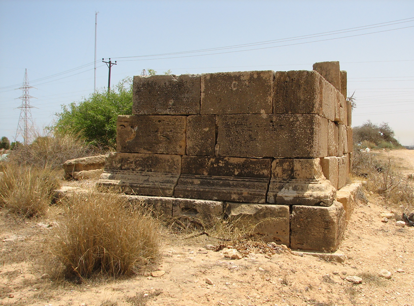
Figure 28. The Gasr Ben Nasser mausoleum (KHM 35). Photo: Archaeological Mission Roma Tre University. (Colour online.)
Actually, the mausoleum has a quadrangular plan (5.9 × 5.4 m at the crepidoma) that corresponds to the dimensions reported by Cowper (4½ paces). It seems also that the structure has suffered some rearrangements from its original aspect and the only ancient part still in situ is the north-west corner. The other sides of the structure were probably built, patching together the original collapsed blocks, during the Italo-Turkish conflict (the site is located c. 400 m south-east of the stronghold named ‘Ridotta Parma’ and the ancient structure seems to have been included in a defensive line: IGM 1913). The architectural pattern (Moore Reference Moore, Stone and Stirling2007, 84–87), together with the epigraphic evidence, should date the mausoleum to between the second and third centuries AD.
2.5.4 Mausolea at the foot of Ras el-Mergheb (KHM 2, 10)
Funerary structures near Ras el-Mergheb were recorded at different times from the nineteenth century onwards. The Beechey brothers (Reference Beechey and Beechey1828, 50) were the first ones in 1821–22 to cite ‘several tombs’ at the foot of the hill. Some decades later, between the end of the nineteenth century and the beginning of the twentieth, the two travellers H. S. Cowper and H. M. de Mathuisieulx – along with a further report written for the Italian Government (Elenco edifici 1912, 45) – were more accurate and mentioned two or more mausolea in the same area.
The first funerary monument surveyed is located at the foot of the Ras el-Mergheb hill, c. 5.5 km west of Lepcis Magna, and close to the modern Tripoli–Khoms road (Figure 23, KHM 2). Today the mausoleum is no longer visible, but its position seems to be confirmed by a regular concrete platform of c. 8 × 7.5 m still visible on the ground. The structure was briefly described by H. S. Cowper (Reference Cowper1897, 215, nr. 6, fig. 61), who saw the podium of the mausoleum with both the vault of the burial chamber and the moulding around the door still in situ (Figure 29). A few years later, de Mathuisieulx (Reference Mathuisieulx1906, 77–78) added general measurements to Cowper's description. The scholar also noticed, 50 m towards the south, the presence of a large quantity of ancient material related to a bourgade. The location of these ruins actually coincides with the remains of ancient structures connected to a farm and a cistern (KHM 3) whose pottery is dated to the first to second centuries AD. The mausoleum would also have been visible at the time of the Italo-Turkish clashes in 1912, because it is mentioned with the generic word ‘Kasr’ on an Italian map (IGM 1913) and it is visible in a photograph taken by Paolo Vinassa de Regny (Reference Vinassa de Regny1913, table VIII). The only element that could help to date this construction is, together with the architectural typology (Moore Reference Moore, Stone and Stirling2007, 84–87), the chronology of the nearby farm (first to second century AD), which is apparently precisely related to the tomb.
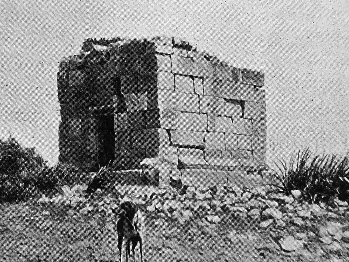
Figure 29. Mausoleum at the foot of Ras el-Mergheb (KHM 2). Cowper Reference Cowper1897, fig. 61.
Another funerary structure (Figure 23, KHM 10) is located c. 800 m east of the mausoleum previously described (Munzi et al. Reference Munzi, Felici, Cirelli, Schingo, Zocchi, Milanese, Ruggeri and Vismara2010, 739–40, fig. 11). The site is characterised by a mound of rubble sized c. 4 × 4 m with different ashlar blocks around it, perhaps a reference to the funerary enclosure. This structure seems to have suffered damage during the Italo-Turkish conflict; it is plausible that the Italian troops used some of its ashlar blocks to build the ‘Ridotta Palermo’ (Palermo Stronghold), which, according to IGM 1913, seems to be located in the same place as the ancient site.
2.5.5 Gasr el-Banât (KHM 107)
On the plain between the ancient coastal road and the Ras el-Hammam hills (c. 3 km south of Lepcis Magna) is located a mausoleum known as Gasr el-Banât (Figure 23, KHM 107; Figure 30). In 1727–28, the Arab travel writer Ibn at-Tayyib described the structure, noting the presence of the heads of maidens (banât is the Arabic term for ‘maidens, girls’), perhaps referring to a Doric frieze or decorations with female busts on them, today unfortunately missing. The mausoleum was briefly cited by Cowper (Reference Cowper1897, 214, nr. 2) and then by other scholars during the first half of the last century (Merighi Reference Merighi1940, II, 61, nr. 19; Romanelli Reference Romanelli1925, 164–65 and fig. 97).

Figure 30. The Gasr el-Banât mausoleum (KHM 107). Photo: Archaeological Mission Roma Tre University. (Colour online.)
The structure, preserved for more than 7 m in height, was built with limestone ashlar blocks and is composed of three storeys. The podium (4.85 × 5.07 m and a height of c. 3.7 m) and the second storey (c. 3.5 m high) are characterised by smooth walls except for the moulded bases and cornices. The only element preserved for the third storey is the base of the north-east corner pilaster. The general plan of the burial chamber is still identifiable: it is barrel-vaulted with three niches at the bottom wall to the west, maybe to house cinerary urns. Although the lack of dateable elements does not allow us to establish an accurate date for Gasr Banât, the typology of this three-storey structure, belonging to the tower-mausoleum type, seems to be similar to that built by the Flavii at Cillium (Hallier Reference Hallier1993), which is dated to the second half of the second century AD.
2.5.6 Gasr Legbeba (KHM 104)
The mausoleum (Figure 23, KHM 104) is located about 5.5 km south-west of Lepcis Magna, on the west side of Wadi es-Snanat (or Wadi el-Uaara), the tributary to the right of Wadi es-Smara. Thanks to Italian maps (IGM 1915; 1918), the site is also known to be located near Gasr Gbeba, or Ghebbaa, the same toponym used by Romanelli (Reference Romanelli1925, 164) to describe a funerary structure. However, the structure outlined by the Italian scholar seems to have been different in its dimension and state of preservation compared with what is actually visible.
The structure (Figure 31), published almost 20 years ago by Jabar Matoug (Reference Matoug1997), is visible for almost all of its burial chamber (4.23 × 3.73 m and 3.93 m in height), built using limestone ashlar blocks; the roof is characterised by a partially preserved concrete barrel vault. On the external corners of the mausoleum are smooth pilasters 25 cm wide and, on the north side above a moulded door, is carved a tabula ansata without inscription. On the roof, part of the cornice is still visible and at least two corners of the same decoration lie upside down on the ground.
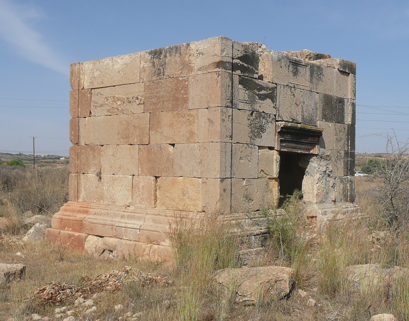
Figure 31. The Gasr Legbeba mausoleum (KHM 104). Photo: Archaeological Mission Roma Tre University. (Colour online.)
There are no architectural elements that would suggest the presence of a further storey and Gasr Legbeba could therefore belong to the ‘dice mausoleum’ type.Footnote 4 Furthermore, the elements that might suggest an accurate chronology are scarce, but on the same site orthostats of opus africanum walls are visible, probably related to an ancient farm that should be connected to the sepulchral monument. Chronological data of the pottery dated the site from the first to the third century AD.
2.5.7 Mausolea at the foot of Ras el-Hammam (KHM 106, 146)
On the north-east flank of the Ras el-Hammam hill, c. 5 km south of Lepcis Magna and a hundred metres from the remains of a large farm, stand two mausolea (Figure 23, KHM 106) built using the limestone from the nearby quarries of the Ras el-Hamman district (see part 2.4). Despite their considerable size, the only scholar to briefly mention these funerary structures was Bartoccini (Reference Bartoccini1927, 115–16), who was much more interested in the Roman farm than the mausolea (a brief description is found in Musso et al., Reference Musso, Baldoni, Baroni, Bessi, Bianchi, Bruno, Buccino, Davidde Petriaggi, Felici, al-Hadad, Munzi, Petriaggi, Shebani, Sjöström and Zocchi2013-14, 36).
The largest structure is partially preserved (Figure 32), but its dimensions can be approximately outlined. The concrete platform (c. 9.85 × 8.80 m) and part of the first rows of limestone blocks are still visible on the ground. The mausoleum would have had a quadrangular plan with one of its sides (the short one) facing the coastline to the north-east. The north-west wall is the best preserved (at a total length of c. 6.50 m) and is characterised by a smooth wall built with ashlar blocks set up on a three-step crepidoma and a moulded base; the structure reaches a total height of c. 7.80 m. In addition, part of the south-west wall is preserved (c. 1.60 m) and, in the corner between the two opus quadratum walls, part of the concrete barrel vault ceiling is still in situ. Due to illegal excavations occurring at the foot of the structure, on the north-east side, the entrance to the funeral chamber is unfortunately full of soil and rubble.
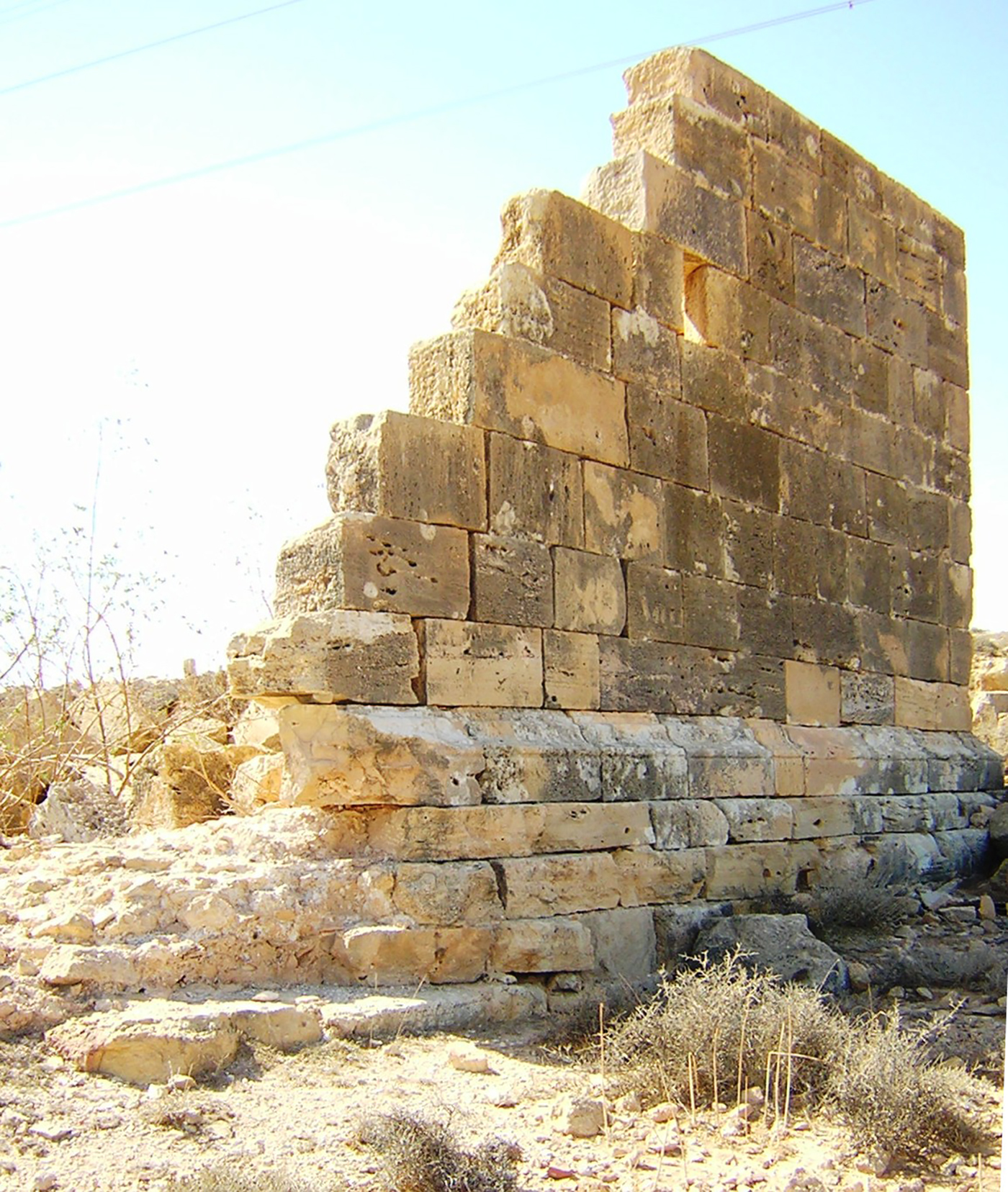
Figure 32. Mausoleum at the foot of Ras el-Hammam (KHM 106). Photo: Archaeological Mission Roma Tre University. (Colour online.)
Another funerary structure is visible c. 70 m east of the previous mausoleum (Figure 33). The platform where it was built is almost a square (7.60 × 7.30 m) and actually its remains are formed by two perpendicular walls (7.50 m and 6.05 m long respectively) at a total height of c. 2.80 m at the corner.
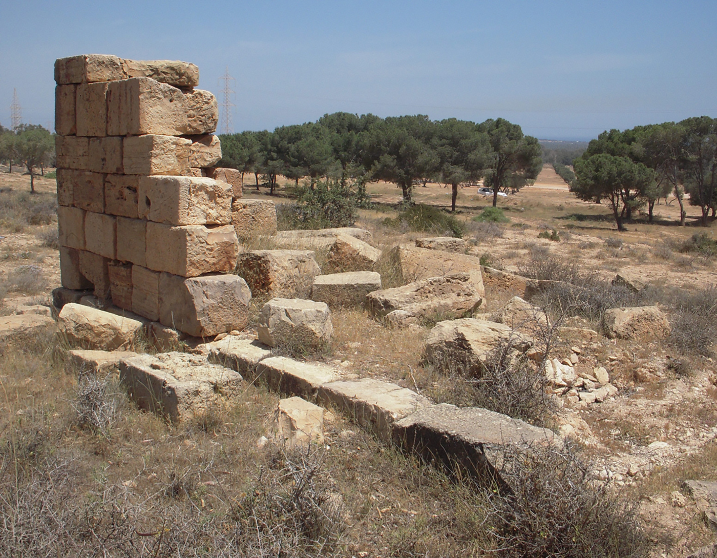
Figure 33. Mausoleum at the foot of Ras el-Hammam (KHM 106). Photo: Archaeological Mission Roma Tre University. (Colour online.)
Both of these structures can reliably be categorised as tower-mausolea. However, the planimetric size of the larger one, as well as its height, suggests an impressive volume that allows us to consider it a temple-mausoleum. Unfortunately, the attempt to date these funerary structures proved inadequate owing to a lack of both the main decorative elements and any epigraphic evidence.
Traces of a further mausoleum are located on the south-west flank of the Ras el-Hammam hill (Figure 23, KHM 146), a few metres from a large ancient villa. Unfortunately, is not possible to recognise its plan or the exact localisation of the structure because its remains are scattered on the ground.
2.5.8 The mausoleum at Wadi Chadrun (KHM 136)
Two rows of limestone ashlar blocks of a funeral structure are visible on the slope of a hill facing Wadi Chadrun (Figure 23, KHM 136). The remains of this mausoleum are very scarce, but its quadrangular shape, if incomplete, is still identifiable on the ground. The structure measures c. 3.80 × 5.80 m and the first row of limestone blocks is preserved on three sides while no traces remain of the fourth (the short one facing Wadi Chadrun).
3.1 The landscape evolution from the Early Islamic to the Ottoman period (M. M.)
While the Umayyad century appears as the extreme continuation of the Vandalo-Byzantine dissolution of rural settlement, with its rare forms of frequentation hardly detectable on the field, the Aghlabid and Fatimid revivals of agriculture and a return to prosperity are documented in a clear manner (Figure 34). Lepcis Magna, now Lebda, and its immediate hinterland became an eastern outpost of Aghlabid Ifriqiya in the direction of the Tulunid or Ikhshidid territories, while the Gebel and the pre-desert, and therefore the trans-Saharan caravan trade, were probably under the control of the Berber state of Ibadi Rustamids (Rushworth Reference Rushworth and Merrils2004, 88–95; Savage Reference Savage1997, 89–111). Owing to the critical nature of its border location, Lebda and the nearby countryside were repeatedly crossed by armies and tribes (Cirelli Reference Cirelli2001, 433–34).
Figure 34. The Aghlabid and Fatimid phase (background image: USACE 1962a–b). (Colour online.)
This was the period when, in the middle and upper Wadi Taraglat as elsewhere in the Gebel and perhaps in the pre-desert, new permanent settlements appeared, either fortified (gsur) or open, linked to the renewed practice of agriculture accompanied by the traditional forms of seminomadic pastoralism (Munzi Reference Munzi, Tantillo and Bigi2010b, 77–80; Munzi et al. Reference Munzi, Felici, Sjöström and Zocchi2014a, with bibliography).
Differently, the Lebda district was not characterised by fortified granaries and fortified villages. An exception is the gasr on the top of Ras el-Hammam, a military fort monitoring the access routes to Lebda from the south and the east, which can be referred to the same architectural type as the Aghlabid Ribat of Sousse and the Fatimid palace-fortress of Ajdabiya. An inscription walled in the portal dates the construction to the year 473 of the Hegira (AD 1080–81) (Abdouli Reference Abdouli2013; see part 3.2). The gasr could be identified with one of the two castles mentioned by Idrisi (c. AD 1099–1165) (Bresc and Nef Reference Bresc and Nef1999, 208; Cirelli Reference Cirelli2001, 426–27; Dozy and De Goeje Reference Dozy and De Goeje1969 [1866], 154): ‘The city of Lebda is located at short distance from the sea. In other times it had been very prosperous and populous; but the Arabs had taken over the city and its surroundings, vanished the prosperity and welfare of the inhabitants, to the point that they were forced to abandon the city. Just two very significant castles still remain, where some Berbers of Hawara tribe have established their dwelling.’
In the suburbs, a revival of open settlements is instead attested, thanks to the finding of pottery of the same type as that produced in the kiln installed among the ruins of the Flavian Temple in Lebda (see part 4). The renewed agricultural prosperity would have been mainly based on olive growing; according to Idrisi: ‘The territory of Lebda produces dates and olives, from which it obtains in the suitable season abundant oil harvesting.’ The cultivation of cereals may also have contributed; it was certainly widespread in the pre-desert where (Wadi Soffegin), according to al-Bakri, the wheat reached a yield of a hundred per one (Mac Guckin de Slane Reference Mac Guckin de Slane1913, 25).
This landscape, which seems to have survived the Bedouin invasion of the mid-eleventh century, may have become more markedly nomadic and pastoral in the twelfth and thirteenth centuries. The scarcity of diagnostic materials could indicate a general decrease in settlement. This possible contraction could be read in parallel with the disappearance of Lebda, abandoned by al-Abdani's time (thirteenth century; Motylinski Reference Motylinski1900, 77), perhaps due to the shifting of the major caravan routes towards Tripoli (Zeltner Reference Zeltner1992).
After the uncertain late medieval interlude, for which we still expect more detailed data, a marked recovery of the rural settlement occurred from the sixteenth and seventeenth centuries (Figure 35), in chronological parallel with the inclusion of Tripolitania into the orbit of the Ottoman Empire, realised in 1551. The pragmatism that initially characterised the Ottoman approach could have played a positive role in the economic resumption. The province of Tripoli (Trablusgarb beylerbeyliği) was characterised by the wide autonomy granted by the Sultan and the delegation of military and administrative power from the governor to the sheikhs of the local tribes for controlling the hinterland (Işıksel Reference Işıksel2012; Micacchi Reference Micacchi1936 for the following Karamanli period).

Figure 35. The Ottoman/Karamanli phase (background image: USACE 1962a–b). (Colour online.)
Agriculture came back along with pastoralism. Literary sources suggest, for example, that olive cultivation was widespread along the coastal strip: the area between the Lebda and Ganima wadis, bordered to the south by the Msellata heights, was called in the seventeenth century al-Gāba, that is ‘woods’ or ‘olive groves’ (Cesàro Reference Cesàro1933, 43).
At the same time, a form of unfortified settlement reappeared in the countryside, identified by the survey with particular density in the northern foothills of Msellata. The rural houses were isolated or grouped to form small villages (KHM 45, 148, cf. in Silin area SLN 19, 61, between SLN 43 and 46, 64), the most consistent of them identified in local toponymy with the term qaryat (as in Qaryat Banu Hassan: Abdouli Reference Abdouli2012). Wells (bīr, pl. abyār) were realised in the vicinity of rural dwellings, but also in the open countryside serving farmland; some of them are still in use today.
Traditional nomadic tents and some military structures for controlling the territory completed the Ottoman-Karamanli landscape. Considering the great difficulty in identifying nomadic frequentations by surveying, given the normal absence of structural remains, the identification of a seasonal encampment appears remarkable. It was found in the Mergheb area (KHM 113) marked on the ground by stones placed to hold the edges of the tents and by the pottery scattered all around. A small square-based tower is probably to be counted among the military structures, located on a hilltop (KHM 166) just south of Ras el-Hammam, where a bronze seal ring has been found, with the name of a notable (or an official) engraved in four rows along with the Hegira date: Hamed / Ali / al-Salem (?) / 1320 or 1325 (AD 1902–7).
In the same period, the landscape was populated by marabouts, the shrines of pious Muslims. These funeral monuments, characterised by a small dome (gubba) sometimes superimposed onto a quadrangular structure (Messana Reference Messana1972), became targets of popular devotion and pilgrimage. A first-rate source for dating the Tripolitanian sanctuaries remains the Chitab el-Isciarat guide written by Abd es Slam-el-Alem in the second half of the seventeenth century (Cesàro Reference Cesàro1933). Particular concentration of marabouts has been recorded in the Silin area (SLN 1, 3, 10, 34, 43, 46, 58, 60) and in the Sahel of Khoms (see part 3.4). Most of the time, the marabouts and their connected villages are located near or among the ruins of ancient rural settlements. The evident reason was the easy retrieval of building materials offered by the ancient ruins. P. Della Cella (Reference Della Cella1819, 31), who visited the area in 1817, noted, speaking of the Zliten region, that ‘often marabouts profited from some remains of old towers to curl up inside’.
Associated with the settlements were found, in significant amounts, pottery of local manufacture as well as those imported from the southern part of Tunisia, in particular large oil jars named habia (pl. huàbi). Even small coins returned in use: in fact, in a small cluster of houses (KHM 129) was recovered a copper coin (para) struck in Tripoli around 1830.
This landscape remained unchanged until the early twentieth century. Just before the Italian occupation in 1911, the Ottoman government had conducted a census of the vilayet’s population. Just over half a million (523,176) inhabitants were recorded, among them 11,910 in Gefara, 10,813 in the Khoms district, 15,579 in the Msellata, 16,407 in the Sahel, 37,966 in the Zliten district, and 50,484 in the Tarhuna area (MC 1913, II, 183–87). This is also the landscape documented by the Italian agrological missions, which arrived in Tripoli soon after the occupation (MAIC 1912; MC 1913; Franchetti 1914; Scarin Reference Scarin1940). Their reports provide valuable information on the agricultural systems (the irrigated gardens, sania-suani; the small dry cultivation, ginan-ginanat; the great dry cultivation) and the different types of settlement prevailing on the coastal strip and in the hinterland, which allow us to integrate the archaeological data collected on the ground.
Finally, some battlefields and forts related to the Italo-Turkish war of 1911–12 and the continuation of hostilities until 1922 have been identified and documented (Figure 36) thanks to a considerable discovery of military artefacts (506) and structures (Munzi et al. Reference Munzi, Cirelli, Felici and Zocchi2013, for a discussion of the 2007 finds).
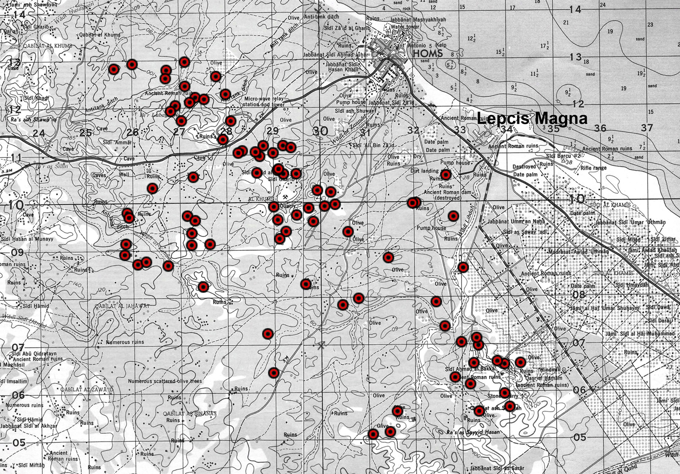
Figure 36. Sites with military finds or with structures related to the Italo-Turkish War (USACE 1962a–b). (Colour online.)
3.2 The medieval gsur (Ras el-Hammam and Ras el-Mergheb) (I. S.)
Writing around the middle of the twelfth century, Idrisi informs us that two forts protected Lepcis/Lebda (al-Idrisi Reference al-Idrisi and Jaubert1836, 84). These should, with some degree of verisimilitude, correspond to those of Ras el-Mergheb (KHM 108) and Ras el-Hammam (KHM 105), respectively six and five kilometres from the centre of Lebda (see Figure 34). Their geographical positions, overlooking a wide area in all directions, are excellent from a military viewpoint, in particular for sounding the alarm in the case of an attack from the hinterland, and may have formed part of the defences of Lepcis Magna in Roman times (see part 2.1). The dating of the two structures is, however, problematic, particularly in the case of KHM 108, whose visible ancient remains in fact date only to the first century AD (see above, part 2.2). The castellum described by de Mathuisieulx (Reference Mathuisieulx1906, 76–77) could have formed part of a medieval fortification, but the brief account does not suggest that this was the case. There may well have been a medieval fort here, but this appears to have been destroyed by subsequent reuse of the site, most notably during the Italo-Turkish war and later. In the future, a more detailed examination of the hilltop could perhaps find some traces of medieval occupation in the form of pot sherds.
In the case of Ras el-Hammam, there are two schools of thought: one sees it as a gasr of Byzantine date, possibly overlying a Roman foundation (Romanelli Reference Romanelli1925, 169); the other believes that the gasr is of Islamic date, suggesting that the eleventh-century inscription over the inner doorway dates the building (Goodchild and Ward-Perkins Reference Goodchild and Ward-Perkins1953, 73), giving a date of AH 473 (AD 1080–81). So far, the inscriptions from the gasr have received more attention than the building itself (Reference Reynolds and Ward-Perkins IRT 481, 780; Levi Della Vida and Amadasi Guzzo Reference Levi Della Vida and Amadasi Guzzo1987, 40; Romanelli Reference Romanelli1925, 169–70; for the Arabic inscription, Abdouli Reference Abdouli2013; Levi Della Vida Reference Levi Della Vida1949; Lowick Reference Lowick1971–72).
In the course of the present survey, it was not possible to make a detailed plan of the building, but with the aid of plans published by Romanelli (Reference Romanelli1925, 169) and Bartoccini (Reference Bartoccini1926, 95, fig. 94), as well as a hitherto unpublished plan by J. B. Ward-Perkins or R. G. Goodchild discovered in the Society for Libyan Studies archive by Andrea Zocchi, it is possible to attempt an interpretation of the site (Figure 37).Footnote 5
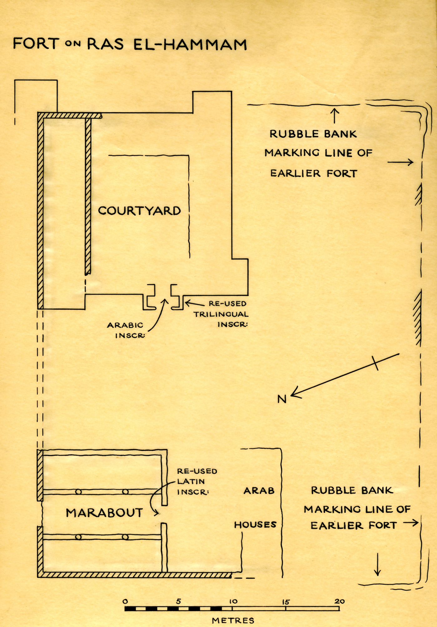
Figure 37. Plan of Ras el-Hammam, showing the gasr and the location of the al-Saba mosque (KHM 105). The earthworks shown on the plan were not distinguishable in 2013. (Plan by J. B. Ward-Perkins and/or R. G. Goodchild, published by kind permission of the Society for Libyan Studies). (Colour online.)
The plan of the gasr is approximately square (according to Romanelli, the gasr measures 17.4 × 18 m),Footnote 6 with the entrance on the west side and four irregular, rectangular angle towers (that on the north-west corner projects less than the others). The portico is characterised by an arched doorway and is the most distinctive feature of the building; there is also a machicolation between the inner and outer doors. On the exterior, to the north of the portico, there are three courses of blocks visible, relating to a room built in a later phase, that today has the appearance of a platform, but which originally must have stood as tall as the portico: the paler colour of the blocks by the north-west corner of the portico shows the imprint of a previous abutment (Figure 38). The perimeter walls have gaps from missing blocks in various places, in particular on the east side. Several reused blocks (from olive presses?) are visible in other parts of the walls (for example, in the lower part of the east and west exterior walls, and on the corner of the south-west tower); other blocks are of the same type of pale limestone as the trilingual inscription (Reference Reynolds and Ward-Perkins IRT 481). All this suggests that more than one building was dismantled to build the Gasr of Ras el-Hammam.
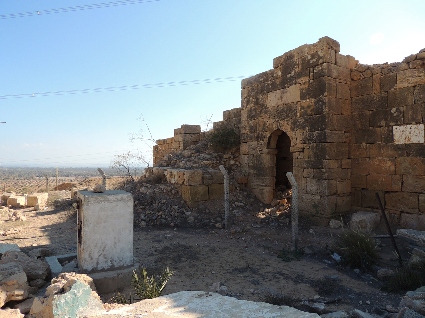
Figure 38. The west wall of KHM 105, showing the portico and the remains of a later addition. Photo: Archaeological Mission Roma Tre University. (Colour online.)
In the interior, several walls are visible, running at right angles to the external walls and belonging to various phases of construction and repair, judging by the variety of building material and techniques employed, but the quantity of collapsed masonry and vegetation make it difficult to reconstruct and interpret the plan. As can be seen in Figure 37 and in the plan by Bartoccini (Reference Bartoccini1926, fig. 94) the northernmost range of rooms is of ashlar blocks (and therefore earlier).
An intriguing feature of the site is the wall in ashlar blocks (Figure 37), which runs west on the same alignment as the north side of the gasr and then turns 90 degrees to the south, forming part of the north and west walls of the nearby mosque of al-Saba. According to Romanelli's description, the plan in Figure 37 and archive photos belonging to Ward-Perkins held at the British School in Rome (WP G23 050a–c; 051a–c; 053a–b; 054a–c; 055b: seen by A. Zocchi), these walls indicate that the gasr was at one point endowed with a large courtyard on its west side, with an arched entrance on the north side where the door to the mosque is now located (Figure 39). None of this is easy to see today, as the mosque doorway presents with a flat lintel, the arch hidden behind a rendering which covers the whole of the exterior north wall of the mosque, executed some time after Ward-Perkins’ visit in the early 1950s. However, following the partial destruction of the mosque by Salafists in 2013, some of the rendering has come loose, revealing the ashlar wall beneath. The matching alignment of the north walls of both gasr and mosque and the similarity of the ashlar masonry of both walls suggests that they belong to a single structure that predates the gasr. The quality of the stonework of the (now hidden) arch, most likely dating to the first century AD, rules out the possibility that the walls now reused by the mosque post-date the gasr. Conversely, it is possible that the entire west wall of the gasr is of a later date than the north wall (Figures 37 and 40), thus explaining the absence of any trace of an abutment or bonding for the continuation of the wall that presumably once ran the length of both the (later) gasr and mosque. In support of this theory is the fact that the portico is bonded to the west face from the seventh course upwards, making it unlikely that it is a later addition to the structure, while it also is very different in character to the arch in the north wall of the mosque. The presence of such high walls next to the gasr, surely not desirable from a strategic point of view, remains a puzzling but incontrovertible fact.
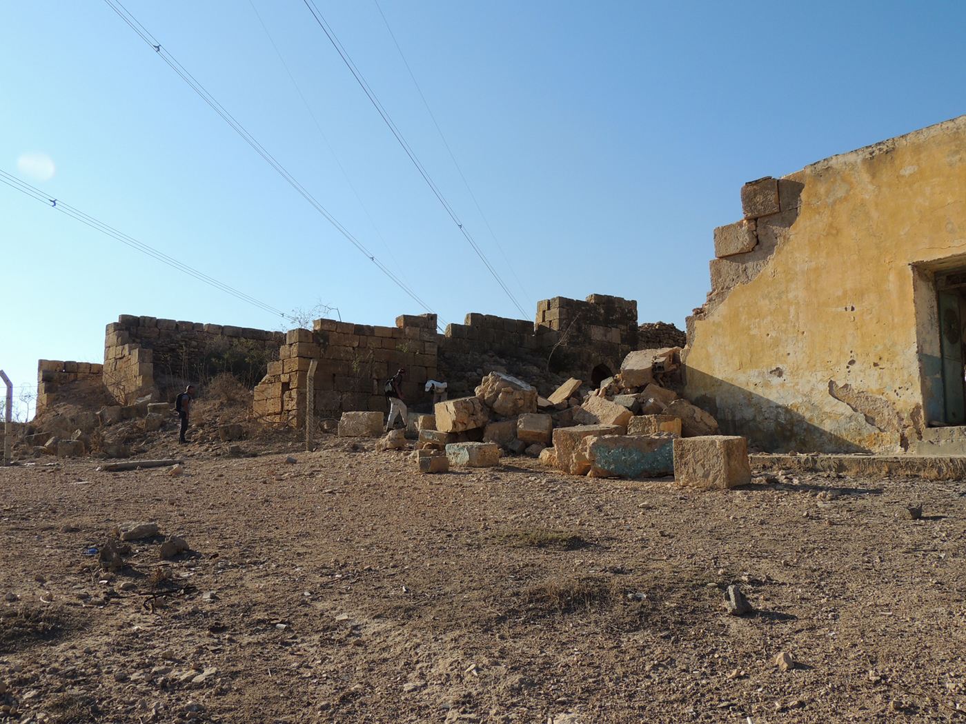
Figure 39. The north wall of the semi-destroyed mosque of al-Saba, with the gasr in the distance (KHM 105). Photo: Archaeological Mission Roma Tre University. (Colour online.)
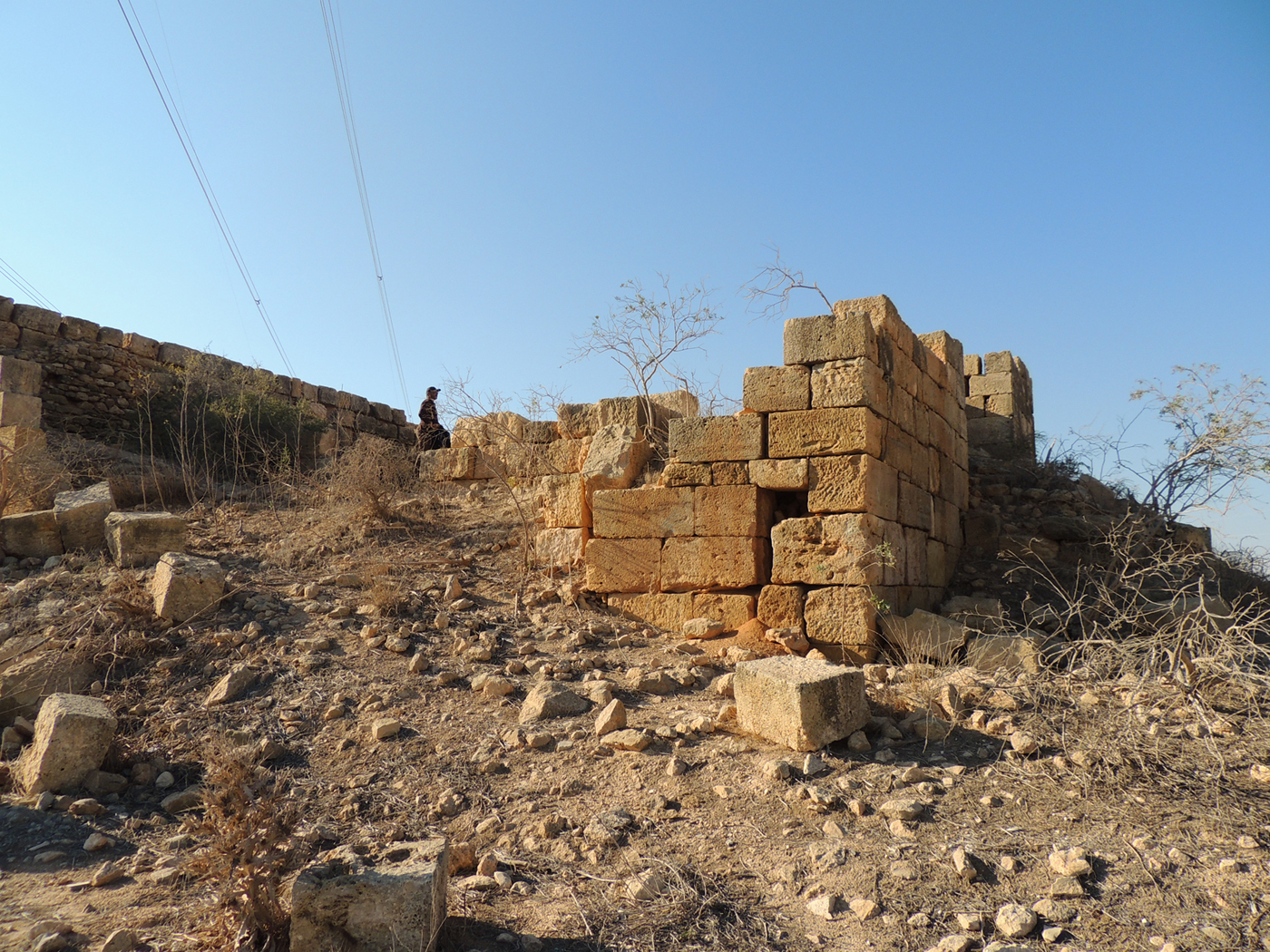
Figure 40. The north-west tower of the gasr (KHM 105), showing the different quality of the masonry, ashlar blocks still in situ and other reused ashlar blocks, on the west face. Photo: Archaeological Mission Roma Tre University. (Colour online.)
3.3 The rural settlements in the Ottoman period (M. M., A. Z.)
3.3.1 Rural houses
The hilly landscape of the Khoms hinterland is dotted with Ottoman-era rural houses (hosc), isolated or grouped (MAIC 1912, 252–55; MC 1913, II, 73–75, 108–9; Scarin Reference Scarin1940, 110–44). They were in most cases already abandoned at the beginning of the 1960s (recorded as ‘ruins’ or ‘ancient ruins’ in USACE 1962a–b).
These structures were built with the pisé technique called darb al-bāb (‘beat with the door’; Aurigemma Reference Aurigemma1962, 30–34) or, more often, with irregular stones alternated with sandy lime mortar beds. The stones, normally small to medium in size, were placed in horizontal layers or in a herringbone arrangement, while for the corners, doorposts and lintels of doors and windows hewn stones as well as ancient spolia material were used (column shafts, torcular orthostats, ashlar blocks) (Figure 41). The floors were made of beaten earth or small stones and they would have been covered by carpets or rush mats (Ajello Reference Ajello1911, 24). Even if often not preserved, the walls would have been covered with plaster both internally and externally. In some buildings, this plaster was externally limited to a vertical strip, serving as a sort of downpipe for the rainwater draining from the terrace, so to avoid infiltrations inside the masonry (S. Franchi in MC 1913, II, 73–74) (Figure 42). The roofs, generally flat, were made of palm branches and fronds, supported by unshaped olive and palm beams. Some structures, with an extremely simple rectangular plan and located in isolated places, could have been used as animal shelters, especially for sheep (KHM 52, 141, 149; see C. Odifredi in MC 1913, II, 108).

Figure 41. Ancient stone elements reused in Ottoman structures (KHM 45). Photo: Archaeological Mission Roma Tre University. (Colour online.)

Figure 42. Plaster vertical strip used as a downpipe (KHM 161). Photo: Archaeological Mission Roma Tre University. (Colour online.)
The houses in our survey are mainly composed of a single area (5–12 m in length and 3–4 m in width), divided into two or three rooms (KHM 53, 87, 129, 147, 158, 159). A significant example is a house located a few kilometres south-west of Ras el-Hammam (KHM 159; Figure 43): it is a long rectangular building (10 × 3 m) enclosed by a wall, realised with unshaped stones and prickly pear plants used to fence off a modest-sized garden; inside are the remains of a small porch, whose frame is made of palm trunks. In the sample, we also recorded more articulated houses, characterised by several rooms facing into a inner courtyard (Figure 44); in other cases, separated blocks, houses or warehouses seem to share a central common space (KHM 29, 45, 56, 99, 161). The furniture was generally reduced to wooden boxes, decorated with nails and/or metal plates; remains (bronze appliqués) have been found in KHM 112 and 148.
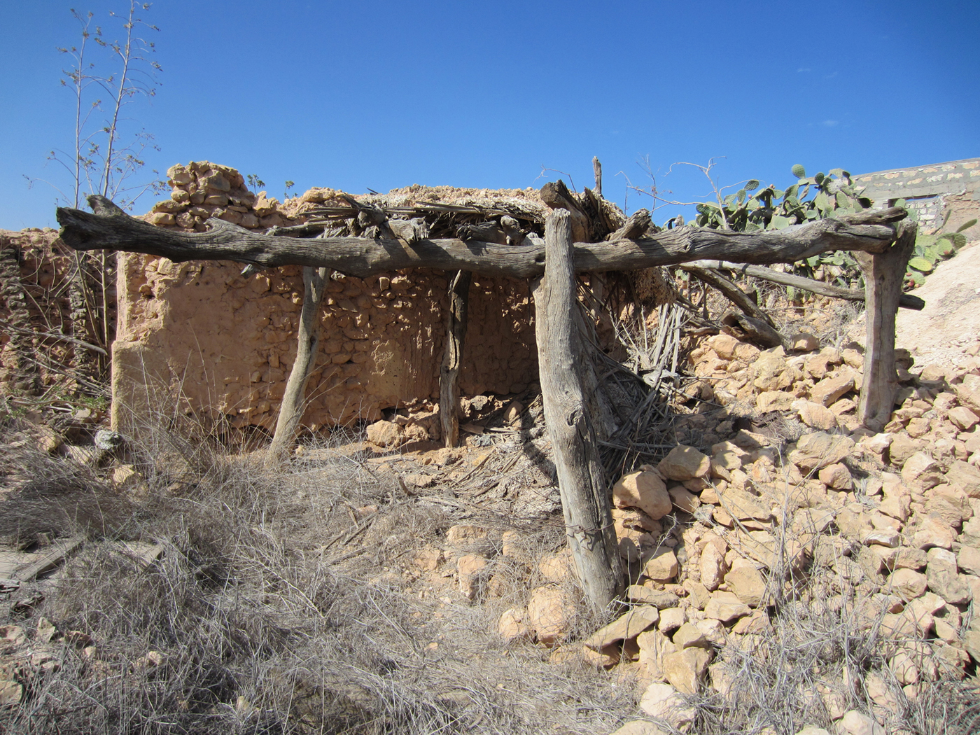
Figure 43. An Ottoman rural house (KHM 159). Photo: Archaeological Mission Roma Tre University. (Colour online.)
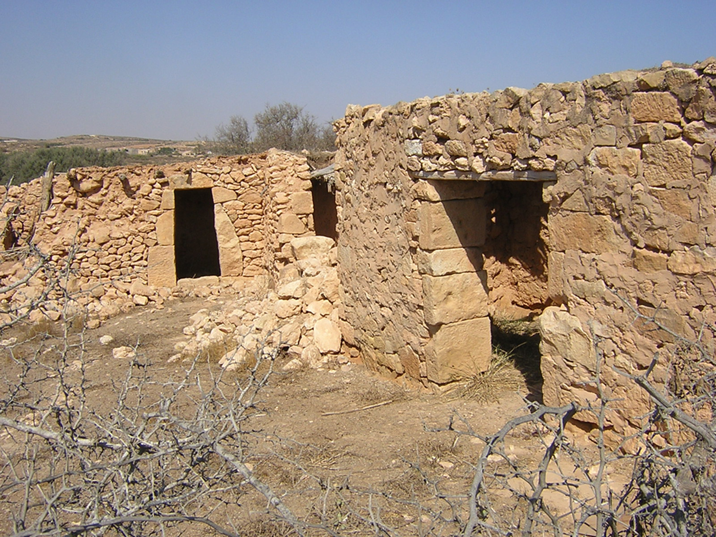
Figure 44. Ottoman houses (KHM 99). Photo: Archaeological Mission Roma Tre University. (Colour online.)
3.3.2 Wells
Wells have often been found near to isolated houses as well as to the house clusters, but not infrequently even far from the dwellings in the cultivated and grazing lands. In the Khoms sample there are two types: the first includes the wells, located along the wadis, which use groundwater (KHM 85, 119, 123, 129, 150, 161; Figure 45); the second is often combined with an underground cistern and takes advantage of hilly slopes for conveying the surface waters (KHM 23, 36, 38, 42, 45, 57, 99, 117, 120, 130, 131, 133, 147, 162, 163; Figure 46).

Figure 45. A well at the site KHM 150. Photo: Archaeological Mission Roma Tre University. (Colour online.)
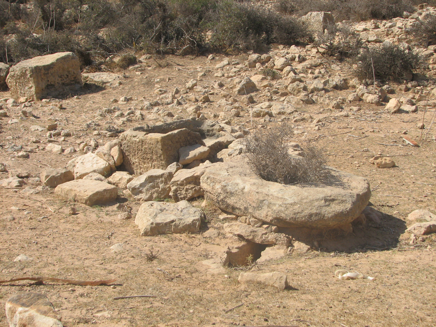
Figure 46. A well at the site KHM 99. Photo: Archaeological Mission Roma Tre University. (Colour online.)
The structures of the first type were usually built in summer along the bottom of the wadis' valleys by skilled workers (stauát). This specialised workforce, once it had reached the groundwater, covered the inner face of the well with stones and lime (even plaster) to give the structure the proper strength (O. Manetti in Franchetti 1914, 284–90). An accurate description of the second type of wells was offered, in the same period, by S. Franchi (MC 1913, I, 86–87, table XXII, figs 1–2). In this case, the hill's slopes acted as an impluvium and an underground cistern with a parapet on the surface was built in the lowest part of the terrain. Before the water flowed into the cistern through a hole at the bottom of the parapet, it had been converged, like a big funnel, by earthern ditches.
With both types, the well curb is not always preserved. However, when present, it has been realised with unshaped stones covered in plaster. In some cases, ancient marble or travertine-like limestone slabs with a hole in the middle have been reused for covering the well. The friction of the rope in the hole caused by pulling up the buckets or goatskins was greater, and therefore it was preferable to use materials that were more resistant and less angular than sandy limestone (KHM 36, 85, 147). In other cases, other ancient elements like basins and bases of millstones have been used as drinking troughs for animals and placed near the same wells (KHM 45, 99, 123, 150).
3.3.3 Underground olive oil mills
Three underground mills (masre) have been documented in the hinterland of Khoms: two of them are located near abandoned houses (KHM 47, 158), another one, completely covered in vegetation, within the outermost perimeter of a gasr, perhaps reusing an ancient underground cistern (KHM 148). In KHM 47, the original access is an opening in the bedrock along the hillside, reinforced with a structure made with unshaped limestone blocks (O. Manetti in Franchetti 1914, 445, fig. 196), while in the other two cases the original access was from above and actually it is not visible because the bedrock ceiling has collapsed, destroying the entrance and partially the oil mill.
The mill at the site KHM 47 is perfectly preserved (Figure 47); most of the components described by the ‘Missione Franchetti’ are indeed visible here (O. Manetti in Franchetti 1914, 445–55). Besides the stone elements such as the base, the farš and the gergāba, most of the olivewood elements are conserved such as the vertical post (ghelb), the frame element at the centre of the mill (garùr), tied to the ghelb, and two cranks (hamèd) which helped push the gergāba. Still well preserved are the esparto ropes that linked the cranks together, while still in place at the foot of the gergāba is a sciamia realised with resistant esparto.
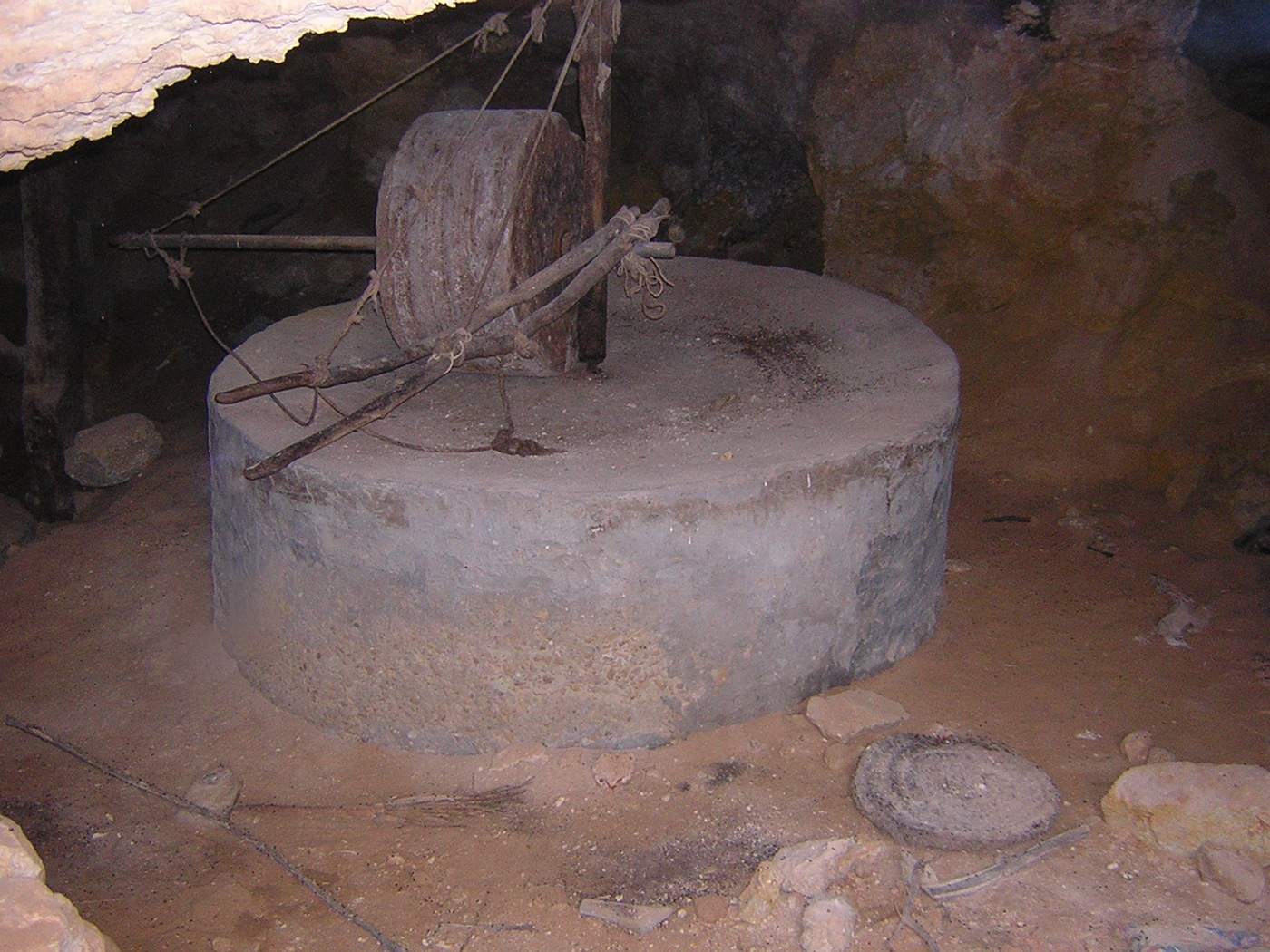
Figure 47. The mill of the masra at KHM 47. Photo: Archaeological Mission Roma Tre University. (Colour online.)
The press is clearly visible in KHM 158, located in the Ras el-Hammam area. In this case, the olive bentàl and the stone elements that hold it, the pivot and the counterweight, are still in situ as well as the esparto sciuàmi stacked below the press. In the same masra are some niches (zuarìf), excavated along the sides of the main chamber (Figure 48), for storing the olives before the mill process (E. De Cillis in MC 1913, II, 212; O. Manetti in Franchetti 1914, 446). The olives were dropped from the exterior surface directly into these niches through holes made in the bedrock; in this way, the olives could be stored in the shade without suffering from the temperature range of the Tripolitanian cold season.
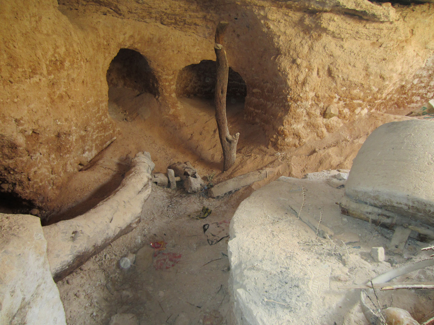
Figure 48. Press elements and zuarif of the masra at KHM 158. Photo: Archaeological Mission Roma Tre University. (Colour online.)
3.3.4 Seasonal camps
Other forms of human presence in the territory normally elude archaeological surveys, and only in conditions of very good visibility is it possible to detect them. This is the case for those seasonal camps with mobile structures and tents (bēt-biūt) which characterised the rural landscape of medieval and Ottoman Tripolitania. For instance, the identification of an area affected by seasonal pastoral activities (KHM 113) allows us to focus on some aspects of Tripolitanian nomadism. A low-density ceramic dispersion area has been detected on this site, characterised by a terrace (c. 80 × 30 m) along a hilly slope near Wadi Chadrun. Significant finds at the site are stones used to anchor the tents and some sherds of European earthenware dated to the late nineteenth century.
3.4 Marabouts and religious structures (M. M., J. M., A. Z.)
In the sample of Ras el-Mergheb–Ras el-Hammam, numerous Islamic religious buildings such as mosques, madrasas and marabouts have been surveyed. The chronology of these buildings is not always clear, because of the lack of architectural dating elements and historical sources.
A mosque, known today by the name of al-Saba, is located on the hilltop of Ras el-Hammam (KHM 105; see part 3.2). The structure was already attested in the final Ottoman period; it was briefly described by Romanelli (Reference Romanelli1925, 170) and mentioned with the name of Sidi Ahmed al-Gandur in IGM 1913 and 1915 maps. The mosque was probably built between the eighteenth and nineteenth centuries, because it is not cited in the Chitab el-Isciarat of Abd es-Slam el-Àlem (Cèsaro Reference Cesàro1933). It has a quadrangular plan and is divided internally into three naves (Figure 49). The columns are composed of ancient architectural elements: granite shafts, three bases turned upside down and a capital. The building, recently semi-destroyed by Salafists in 2012 (see Figure 38), preserves large sections of its perimetric walls. The structures seem to have been built using limestone ashlar blocks from the adjacent Gasr el-Hammam and, according to Romanelli, were parts of the original enclosure of the same gasr (see part 3.2).
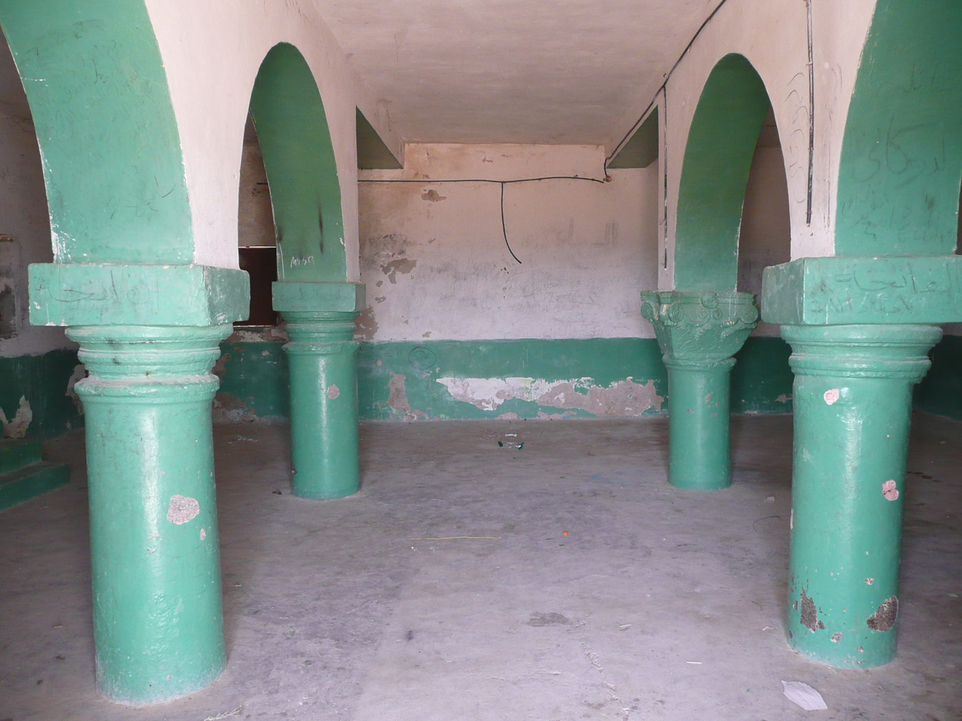
Figure 49. Ras el-Hammam (KHM 105), the interior of the al-Saba mosque in 2009. Photo: Archaeological Mission Roma Tre University. (Colour online.)
Another religious building (KHM 44) has been surveyed in the southern outskirts of Khoms. According to Cesàro (Reference Cesàro1933, 47–48), this structure, named Sidi Zaid el-Garib, should be identified with the Mèsged (mosque without a minbar) Umm Gorbàn mentioned by Abd es-Slam el-Àlem behind Leggāta (Sjöström Reference Sjöström1993, 139, nr. 26). The historical cartography mentioned it as ‘Moschea Sidi Zuaiet’ (IGM 1913) and ‘Sidi Ali Bin Zayid’ (USACE 1962a), while another Italian map (IGM 1915) cited a ‘Sidi Zaid’ mosque near Wadi Tualeb, c. 3.5 km NW of the structure surveyed. The building is composed of two contiguous volumes (Figure 50): the eastern one, characterised by a ribbed gùbba (dome) set upon an octagonal drum, should probably date to the sixteenth century. Here was buried the venerated saint Sidi Zaid al-Garib, whose tomb was still visible at the time of our visits. The western unit was leant against the other to host the tomb of another marabout who, according to local oral tradition, was originally buried outside in a small cemetery. Even this marabout complex has been recently (2012) bulldozed by religious fundamentalists.
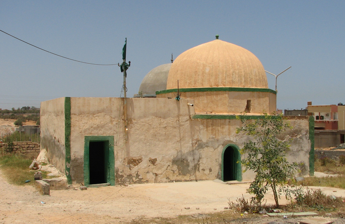
Figure 50. The marabout of Sidi Zaid el-Garib (KHM 44) in 2009. Photo: Archaeological Mission Roma Tre University. (Colour online.)
Other small marabout structures, often built among the remains of gsur or in proximity to other ancient sites, are scattered in the hinterland of Khoms: Sidi Rāquid al ‘Arsah (KHM 21) characterised by a small dome (Figure 51); Sidi al-Gharib (KHM 37) with a rectangular plan; small marabouts near the Ammud mosque, within Gasr Wafi (‘Sidi Uafi’ in IGM 1937), at Henscir Malusha and at Gasr Gus (respectively KHM 50, 82, 99 and 100).
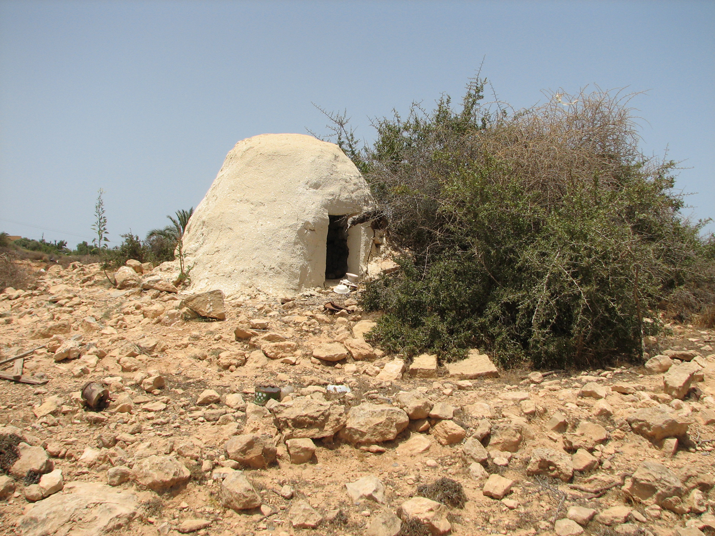
Figure 51. The marabout of Sidi Rāquid al ‘Arsah (KHM 21). Photo: Archaeological Mission Roma Tre University. (Colour online.)
4. The pottery (F. F.)
In association with the 168 surveyed sites, more than 7,500 objects have been collected, including pottery fragments, metal elements, lithic fragments, painted plaster, and others (Table 4).
Table 4 Objects collected in the surveys (2007–13).
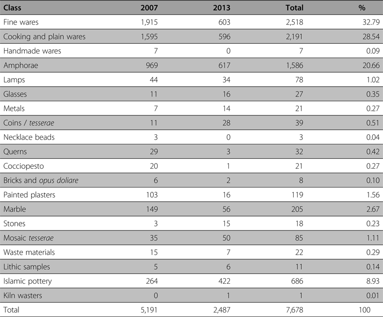
The most numerous class of object is the fine ware with more than 2,500 fragments collected, equivalent to 32.79% of the total; the second most important are the cooking and plain ware with more than 2,100 fragments collected, equivalent to 28.54% of the total, followed by the amphorae with more than 1,500 fragments (20.66%). The Islamic pottery is attested with more than 600 fragments, 8.93% of the total. Among the fine ware, the Italian Sigillata is the most numerous pottery collected followed by the black-glazed ware dated to the Numidian period and the Late Antique Tripolitanian red slip ware (RSW) (Figure 52). Concerning the numismatic evidence, in 2007–13, 39 coins were recovered, together with a seal ring and a lead seal (Munzi Reference Munzi2013 for the coins recovered in 2007 and in previous surveys).
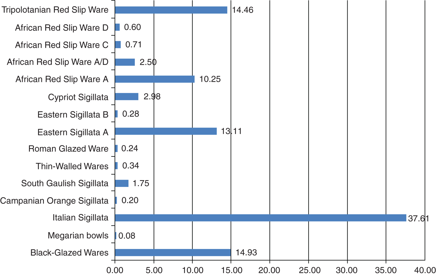
Figure 52. The fine wares: a quantitative histogram. (Colour online.)
A first examination of the histogram of the fine wares allows us some comments. For the second and first centuries BC, black-glazed wares were the most common pottery collected. Most of the fragments seems attributable to Campana A production, produced in the Campania region, while only a small part belong to Campana C, characterised by a grey fabric and produced in Sicily. A local production is also attested, recognised, too, in Sabratha (Keay Reference Keay, Fulford and Tomber1994, 52–62). The Megarian bowls are, in this survey sample, not very common like other samples along the Tripolitanian coast. For the first century AD, most of the fine wares collected belong to the Italic peninsula: for instance, the Italian Sigillata reaches very high percentages (37.61%) while the Campanian Orange Sigillata, like the thin-walled wares and the Roman glazed wares, are attested in minimal percentages. A second group is that produced in the eastern part of the Mediterraneum. The most common the Eastern Sigillata A (13.11%), followed by a small amount of Cypriot Sigillata (2.98%), while the presence of the Eastern Sigillata B is very scarce. For the western provinces is attested only the South Gaulish Sigillata, which reaches a significant percentage like in other survey samples of the Lepcitanian territory. However, the types of South Gaulish Sigillata found in these sites seem to be only plain ware including ‘marble-glazed’ types.
The pottery fragments collected in the survey show the presence of the most ancient types of African RSW A that, for the first period, were found together with the Italic and eastern productions while, from the second century AD, these extra-regional productions were gradually replaced by these African fine wares. From the second half of the second/first half of the third century AD onwards, fine ware imports seem to have been monopolised by African RSW A2, and particularly by African RSW A/D, reaching 2.5% of the total (the diffusion of this last pottery class seems to be equal to the percentages of other urban and suburban areas). From the fourth century AD, the import–export market seems to have changed, becoming more self-reliant, thanks to clear evidence of the use of Tripolitanian RSW (14.46%) produced locally (Reference Carandini, Anselmino, Pavolini, Saguì, Tortorella and Tortorici Atlante I, 137–38; Felici and Pentiricci Reference Felici, Pentiricci, Khanussi, Ruggeri and Vismara2002, 1883–86; Hayes Reference Hayes1972, 304–9). However, for the fourth century AD and the first half of the fifth, extra-regional imports are attested, if only in minimal percentages. The situation in the Lepcis city centre appears to have been different, where, thanks to the harbour and direct access to the different Mediterranean markets, imports of African RSW C and D were more important. These two different productions reach, for instance in the Flavian Temple, 36.3% and 32.8% respectively of the total fine ware finds while the Tripolitanian RSW (35.5%) seems to have been similar in quantity (Fontana Reference Fontana, Bacchielli and Aravantinos1996b, fig. 3). Similar percentages were recorded in the Old Forum (De Miro and Polito Reference De Miro and Polito2005). A substantial decrease in findings from the second half of the fifth century AD is registered in this survey sample. Compared with previous periods, the scarce diffusion of pottery, including local productions, seems to be related to a real rarefaction of settlements. Indicators for this period are essentially for the later types of Tripolitanian RSW (mostly Hayes 8A and B). Unfortunately, up until now, the lack of certain chronologies for pottery of the seventh and first half of the eighth century AD does not help to link the final period of the Late Antique/Byzantine period with the initial Islamic period, when the Lepcitanian inland seems to have been sparsely inhabited.
While for the fine wares, imports from different areas of the Mediterraneum prevailed, the amphorae finds have shown a large percentage of local/regional productions (69.5%) compared with the imports (30.5%). The local/regional productions include amphorae for wine – types Schone Mau XXXV and African Dressel 2–4 – as well amphorae for olive oil – Tripolitanian 1 and 3. The Tripolitanian 2 and its ancient variation Benghazi ERA 11b could have also been used for garum. The main imports registered were from Italy and Sicily, while imports from Spain, Gaul, Africa and the eastern provinces were scarce (Table 5).
Table 5 Amphora types.
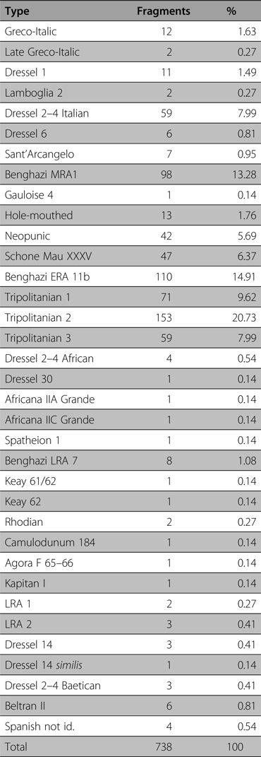
Significant are the wine and garum amphorae. From the Hellenistic period are attested North African Punic (hole-mouthed) and Greco-Italic amphorae, followed by types Dressel 1 and Lamboglia 2 of Italic amphorae for wine; occasionally, fragments belonging to Rhodian amphorae have been also recorded. From the early Imperial period, the importations of Italic wine seems to have been significant: the most representative types are Benghazi MRA 1 (first to fourth century AD), probably produced in Sicily (for a long time considered a Tripolitanian production), followed by the Dressel 2–4, mostly from Campania. Even for this period, amphorae for wine from the eastern provinces (Camulodunum 184, Agora F 65–66 and Kapitan I) have been found. Numerous also are the imports from Spain for both garum (Dressel 14, Dressel 14 similis, Beltran II) and wine (Dressel 2–4 Baetican). From the mid-Imperial period are registered imports from Africa (Dressel 30, Africana IIA Grande and IIC Grande), while in the late Imperial period imports became scarce and few types are recorded: Spatheion 1 and Keay 62 from Africa and LRA 1 and LRA 2 from the eastern provinces.
With the settlement revival in the Aghlabid-Fatimid period, in the harbour of Lepcis Magna/Lebda a similar pottery diffusion is recorded in this survey sample. In the excavations led in the Flavian Temple by Enrica Fiandra, a kiln associated with a large pottery production area was documented. The production, at the beginning considered Byzantine (Dareggi Reference Dareggi1969, 362), was then correctly dated to the Early Islamic period (Dolciotti and Ferioli Reference Dolciotti and Ferioli1984). A recent examination of the waste material has permitted us to recognise different shapes of unglazed pottery such as bottles, bowls, cups, dish lids, amphorae and lamps, all characterised by a cream-green coloured fabric (Dolciotti Reference Dolciotti2007). This pottery production has also been attested by André Laronde in the Islamic village which grew up inside the Lepcis harbour basin; in particular two types – a small globular amphora with a peculiar rim and a ‘button’ bottom, and a bottle with a tubular spout – demonstrate a significant diffusion of this production in the inner Lepcitanian territory (Cirelli Reference Cirelli2001, 430–31; Cirelli et al. Reference Cirelli, Felici, Munzi and Galetti2012, 772–73). Both the globular amphorae and bottles with a tubular spout have also been found at Medina Sultan (the ancient Surt) and in the Djerba area. Similar shapes have been recorded for the late nineteenth century and, with further variations, even in Sicily.
The presence of the glazed pottery is scarce and it is recorded only in the coastal urban settlements dated to the end of the tenth century, in particular a tableware that seemed to address only the elites and that would spread especially in the eleventh and twelfth centuries. Most of the sites of this field survey sample, up until now, do not attest these pottery classes.
5. Preliminary conclusions (M. M., A. Z., F. F.)
Our analysis has highlighted the conjunctural alternations between economic growth and contraction, but at the same time the articulation of the settlement production systems that followed one another through the ages, in which agriculture, sedentary or seasonal, and pastoralism alternated and sometimes coexisted, was also a function of the different levels of openness of Tripolitania to the Mediterranean markets. What followed was, in extreme synthesis, an evolution of the forms of occupation of the territory from the Hellenistic period, the age in which the first rural settlement appeared, to the dawn of the twentieth century.
1. The Hellenistic phase shows that the settlement was denser here than elsewhere in the Lepcitanian territory. The new positive political situation which allowed Lepcis to be more independent from Carthage (especially after the Battle of Zama in 202 BC) could have favoured the flourishing of the Lepcitanian hinterland landscape, already in the third century BC and especially in the second. Moreover, it seems convincing that this economic growth could be related to a substantial development in the urban texture of Lepcis Magna (Masturzo Reference Masturzo2013, 203). The black-glazed wares were the most common fine ware class collected (mainly Campana A production from the Campania region, with a small amount belonging to Campana C from Sicily and to a local production, recognised also in Sabratha: Keay Reference Keay, Fulford and Tomber1994, 52–62). Moreover, North African Punic (hole-mouthed) and Greco-Italic amphorae have been recorded alongside Italic amphorae for wine, types Dressel 1 and Lamboglia 2, and occasionally fragments belonging to Rhodian amphorae.
2. In the first and middle Imperial periods, farms and villae spread everywhere (this was a usual trend in Tripolitania). They were systematically provided with facilities for olive oil and possibly wine production. The development of this landscape and the wealth of the high-income class are expressed also by the numerous mausolea built in this period. Furthermore, the suburban landscape was specifically marked by an intense exploitation concerning the extraction of limestone. The huge quarries of the Zennad and es-Smara wadis and the Ras el-Hammam district would have mainly supplied the large urban building sites. Most of the fine wares dating to the first century AD belong to the Italic peninsula; in particular, Italian Sigillata reaches very high percentages. From the eastern part of the Mediterraneum, the most common class attested is the Eastern Sigillata A, followed by small amounts of Cypriot Sigillata and Eastern Sigillata B. For the western provinces, only the South Gaulish Sigillata is attested. Concerning the amphorae, the importation of Italic wine is the most significant (Benghazi MRA 1 were probably produced in Sicily and the Dressel 2–4 mainly from Campania) followed by the wine productions from the eastern provinces. Numerous also are the imports from Spain for both garum and wine.
3. A first slight contraction recorded in this survey sample during the third century AD could be related to the post-Severan urban crisis. The reduction in agricultural settlements fits in well, for instance, with both the lack of maintenance of the Wadi Lebda dam from the second half of the third century and – at the end of the same century – the partial siltation of the Severan harbour of Lepcis Magna (Pucci et al. Reference Pucci, Pantosti, De Martini, Smedile, Munzi, Cirelli, Pentiricci and Musso2011, 180–81, 183). From the second half of the second century AD/first half of the third onwards, fine ware imports seem to have been monopolised by African RSW A2, and particularly by African RSW A/D. For the mid-Imperial period, imports from Africa are registered (Dressel 30, Africana IIA Grande and IIC Grande).
4. During the Late Antique period, a situation characterised by ‘declining stability’ has been registered: the continuity of production and import and export (attested especially by fine ware pottery – Tripolitanian RSW for local production and African RSW for import – and amphorae – Tripolitanian 2 and 3 for local production and LRA 1, LRA 2, Spatheion 1 for import) has shown an economic and agricultural system that, even if it could not be compared with the previous phase, was somehow still vibrant. This is the period when many villae and open farms were turned into fortified farm buildings (gsur).
5. The break in the continuity of the ancient agricultural system arrived in the mid-fifth century AD, in a significant parallel with the fall of Tripolitania under the Vandals. Similar trends have been registered in the other Lepcitanian samples explored by us, as well as in Djerba and Kasserine, while in Carthage, Dougga and Segermes the phenomenon seemed to appear in the late sixth century AD. It seems, therefore, that the rural population around Lepcis, already decreased, started to convert to pastoralism and semi-nomadism. The rarefaction of settlements is registered also by the substantial decrease in findings: the main types attested for this period are the late production of Tripolitanian RSW (mainly Hayes 8A and B).
6. The seventh and eighth centuries seem to mark the end of the last sedentary villages and farms around Lepcis Magna, even if archaeological remains are attested within the ancient city (see part 4). Although two Umayyad bronze coins have been recovered from two sites in the Gasr el-Hammam area, very scarce are both the finds (seventh-century forms of African RSW are not attested) and the structural evidence related to this period found in this Lepcitanian survey sample.
7. In the Aghlabid and Fatimid periods, rural settlement experienced a revival. But, different from the inland territories (that is, the Taraglat area), the area around Lebda was not characterised by fortified granaries and villages, with the exception of the military fort of Gasr el-Hammam. The reoccupation or frequentation of ancient sites is the main key point of the renewed rural system which, according to Idrisi, was based on the olive-growing. The sites are dated by unglazed pottery which comprises bottles, bowls, cups, dish lids, amphorae and lamps, all characterised by a cream-green coloured fabric. A kiln associated with a large production area of this pottery was documented in the harbour of Lepcis Magna/Lebda.
8. A nomadic and pastoral transformation may have occurred in the twelfth and thirteenth centuries, considering the scarcity of diagnostic materials recovered in the countryside, in parallel to the disappearance of Lebda.
9. In the Ottoman period, agriculture experienced a new period of growth, together with forms of unfortified settlements: rural houses, isolated or grouped in small villages (the qaryat), equipped with wells (abyār) and cisterns. Simultaneously, the marabouts appeared on the landscape, characterising it until recent years. For this period is attested a significant increase in the ceramic material, among which products imported from the nearby island of Djerba are registered.
10. Finally, in the lands around Khoms and Lebda, battles were fought and forts were built during the Italo-Turkish war of 1911–12, in the Great War years and during the continuation of hostilities until 1922. On the ground have been collected cartridge casings, bullets and clips of the Italian loader rifles Vetterli Vitali 1870/87 and Carcano 1891, but also cartridge casings and bullets of the Turkish Mauser rifle M 1887. Splinters and lead shrapnel balls testify to the widespread use of artillery.
The suburb of Khoms, the object of the archaeological survey project presented here, is rapidly changing due to urban expansion and massive edification, resulting in heavy losses in terms of cultural heritage. In most recent years, to the destruction caused by uncontrolled building activity has been added the ideologically driven destruction of almost all of the religious monuments (in particular the marabouts) of the Ottoman age which were scattered across this territory.


