


Overview
During the Last Glacial Maximum (LGM), the ice shelf in the Weddell Sea region thickened substantially and extended ∼450km further north to the continental shelf break (Reference HuybrechtsHuybrechts, 2002), while the smaller ice shelves in the Antarctic Peninsula extended further to the east and west. The loss of this additional ice mass during the deglaciation may have contributed as much as 6 m of sea rise (Reference HuybrechtsHuybrechts, 2002). As the glacial ice sheet receded, ice caps formed in the Filchner–Ronne Ice Shelf (FRIS) on high spots in the bathymetry, forming independent centres of ice flow such as the Korff and Henry Ice Rises. Berkner Island (Fig. 1; Table 1) is a massive ice rise, which may still have been an independent centre of ice flow during the LGM, though radar studies suggest the current flow centres may have stabilized as recently as a few thousand years ago (Reference Martín, Hindmarsh and NavarroMartin and others, 2009). The FRIS is fed by ice streams draining the West Antarctic ice sheet, some of which are bounded by further ice rises on their flanks: one such is the Rutford Ice Stream bounded by the Ellsworth Mountains to the south, and Fletcher Promontory, an ice rise, to the north.

Fig. 1. Location of the Weddell Sea and Antarctic Peninsula deep ice-core drilling sites, together with the BAS station Rothera.
Table 1. Location and physical characteristics of the three intermediate-depth drilling sites
The British Antarctic Survey (BAS) has a long-term aim to recover intermediate-depth ice cores from these ice rises in order to understand the regional climate and the LGM configuration of the Weddell Sea ice sheet, and the drawdown of ice and contribution to sea level during the deglaciation. The smaller ice shelves to the north of the Peninsula are likely less dynamically stable than the massive FRIS, and several have shown rapid loss of ice or even complete collapse in recent decades. Understanding the long-term climate of the northern Peninsula using local deep ice-core records may help to set in context the recently observed rapid changes.
Considerable progress has been made in recovering intermediate-depth ice cores from the Weddell Sea region. A joint UK/French team from BAS and Laboratoire de Glaciologie et Géophysique de l’Environnement (LGGE) successfully drilled an ice-core to the base of the ice sheet on Berkner Island (Fig. 1). Reference Mulvaney, Alemany and PossentiMulvaney and others (2007) described the drilling operation logistics and equipment in detail. Briefly, the Berkner Island project required three successive field seasons to complete the borehole, using a minimal team of between six and eight on site. One season (2002/03) was required for setting up the drilling infrastructure in a 4.0 m deep cavern beneath a 14.6 m × 4.3 m Weatherhaven shelter, drilling and casing a pilot hole to 70 m. Two further seasons were required to complete the drilling to the bed at 948 m in a fully balanced borehole with a D60/HCFC141b drilling fluid, with the break between seasons at 526 m depth. A fourth season (2005/06) on site was required to measure the borehole temperature, recover basal sediment and recover the drilling equipment from the field.
Following the success of this operation, we proposed drilling to the bed at James Ross Island (JRI) at the northern tip of the Antarctic Peninsula (Fig. 1; Table 1). With an ice thickness of ∼350–400m on the dome of JRI (Mount Haddington), a single-season operation was planned. JRI is readily accessible from the sea during the summer and we were fortunate to access the operational capacity of the Royal Navy ship HMS Endurance and its two Lynx helicopters. A small amount of cargo was pre-deployed to the chosen drilling site in 2006/07. The majority of the cargo and personnel were transported to the site by HMS Endurance, and deployed to the field using the helicopters in early January 2008. A small team of seven on site successfully drilled an ice core from the surface, reaching the bed of the ice at 363 m depth. Following logging of the borehole, the fluid was removed from the hole for reuse on a later project, and to minimize environmental impact. Further operational support was provided during the middle of the season by the BAS Twin Otters flying from Rothera to recover the ice cores to freezers at Rothera, and to assist with rapid uplift at the end of the season in February 2008, when the entire field infrastructure and remaining ice cores were removed from the field, leaving a clear site.
Encouraged by the experience of rapid drilling on JRI, we planned a far more ambitious project to drill to bedrock in a single season on Fletcher Promontory in the southwest corner of the Ronne Ice Shelf (Fig. 1; Table 1). The site chosen was >650 m thick. No pre-deployment of equipment other than emplacing an automatic weather station (AWS) was possible before the chosen drilling season of 2011/12. All the drilling infrastructure and personnel were deployed to the site by BAS Twin Otters operating out of Rothera Station. A team of seven again successfully recovered an ice core from the surface to the bed at 654.3 m depth and, as at JRI, recovered the fluid from the borehole after logging its temperature. The entire drilling infrastructure was removed from the site at the end of the season, other than some of the ice cores (lack of freezer capacity at Rothera), leaving a clear drilling site. The few remaining ice cores were recovered in the following season.
Common Aspects of the Logistics and Infrastructure
The major constraint on UK-supported field operations has been the need to deploy equipment and personnel to the field from UK Antarctic coastal stations using small aircraft. Until very recently, BAS had no capacity for a large overland tractor traverse to bring heavy logistics to deep-field remote sites, though recently it has begun to use PistenBullys for large overland traverse science projects and for the logistic movement of heavy equipment in the field. BAS operates two ice-strengthened ships for ocean research and to support the UK Antarctic research stations. A de Havilland four-engine Dash-7 provides an intercontinental link from South America and the Falkland Islands to BAS’s gravel runway at Rothera Station, and operates further south to a blue-ice runway (Sky Blu) in the south of Palmer Land. Deep-field operations are supported by four de Havilland ski-equipped Twin Otters with a maximum cargo capacity of ∼1000kg operating out of BAS’s stations at Rothera and Halley, Sky Blu and its logistic staging station Fossil Bluff (both Sky Blu and Fossil Bluff are summer-only operations). The UK Royal Navy operated an ice patrol vessel, HMS Endurance, with two Lynx helicopters, and provided some support for near-coastal Antarctic field science projects.
For normal large deep-field operations, cargo is shipped to Antarctica, normally in the season prior to deployment, with field personnel and ‘last-minute’ light cargo transferred from the Falkland Islands or Punta Arenas by Dash-7 to Rothera, with some movement of equipment and personnel further south to Sky Blu. Final deployment to the field site would then be by Twin Otter aircraft. This transport pathway puts quite severe limits on the ice-core drilling equipment, which must be capable of Twin Otter transport and of handling in the field without the benefit of lifting equipment.
The detailed design of the drilling operation developed for Berkner Island, and deployed with some modifications to JRI and Fletcher Promontory, is described elsewhere (Reference Mulvaney, Alemany and PossentiMulvaney and others, 2007). Common to each of our three intermediate-depth drilling projects is the use of a 14.6 m × 4.3 m Weatherhaven Series 4 shelter to house the drilling and core-handling infrastructure, mounted on a wooden floor (panels over joists) either in a deep pit (Berkner) to allow a tilting mast, or directly on the surface (JRI and Fletcher) with a slot cut in the roof of the shelter for the mast. Power to the drilling operation, and for some domestic and personal load, was supplied by a single three-phase 400 V 50 Hz (plus single-phase 240 V, 50 Hz) generator set powered by a three-cylinder liquid-cooled diesel engine running at 3000 rpm, fuelled by Avtur aviation fuel with the addition of two-stroke oil at a 5 0 : 1 ratio. For the site supplied by under-slung helicopter loads from the ship (JRI), we used an SDMO T22K 20 kVA generator in an acoustic housing weighing ∼560kg. For the Twin Otter-supplied camps (Berkner and Fletcher) we used an open frame SDMO model TN16K 16kVA generating set housed in a small tent; this unit, while noisier in camp, weighed only 380 kg. Fuel consumption was ∼3.2Lh−1 for the smaller unit, and 4.3 L h−1 for the larger. A variety of smaller Honda petrol generators (single-phase 240Va.c, 1.0–4.0kVA) were used for building the infrastructure, leisure, and personal use, particularly when the main generator was switched off during periods when drilling was not in progress. The camp personnel (eight on Berkner, seven on each of the JRI and Fletcher projects) slept in two-person pyramid tents, but ate and relaxed communally in a Polarhaven shelter (7.3 m × 3.7m), while a separate Weatherhaven Series 4 shelter (8.5 m × 4.3 m) was used for storage and equipment repair.
Common Aspects of the Drilling Equipment
Full details of the drilling system designed and built for the Berkner Island project are provided in Reference Mulvaney, Alemany and PossentiMulvaney and others (2007) and summarized here. The winch system was built by MacArtney A/S with a Lebus drum carrying 1100m of 8.4 mm diameter Schlumberger ten-core armoured cable with a 38.8 kN breaking strain (mass 280 kgkm−1), driven by a VEM 9 kW (3× 400 V, 50 Hz) motor through a Tramec TC160C gear reducer from an Omron 3GM3MV-A frequency inverter, capable of a maximum winding speed of 43 m min−1, with a maximum pull of 15 kN. Mounted on the winch frame is the tilting mast which can be split for transport, and tilted from horizontal to vertical using an electric motor. The overall mast/winch/cable system weighs 1100 kg, but is broken down to components with a maximum weight of 380 kg for transport. The drill has its heritage in the Hans Tausen and EPICA designs, with a motor driving a hollow shaft, a volumetric pump system (or an alternative spiral booster pump) and a core barrel with drill head, inside a fixed outer tube with an anti-torque section using flat skates of spring steel. The motor/gear section uses a 190V permanent magnet d.c. motor producing 600W at 2000 rpm, with a continuous stall torque of 2.1 Nm, through a gear reducer to give 10–80 rpm at the drill head. Driven at a maximum of 160 V at the surface, with 50 V cables loss, the drilling generally required 1.0 A at the start of the run, rising to 2.5 A at the end. Power passed to the cable through a Focal type 180/12 12-channel slip ring. No sophisticated electronics section for drill performance was included in the drill for simplicity, and although the cable had the capacity to pass analogue load, tachymeter and anti-torque signals from the drill, in practice the monitoring circuits rarely worked and drilling was essentially blind apart from cable load, winch speed and voltage/current of the drill motor.
The bulk drilling fluid for all three projects was ExxonMobil ‘Exxsol’ D-60 with a density of 0.790 Mgm−1 at 15°C. No densifier was used at JRI and Fletcher, though the earlier Berkner operation had used HCFC-141b successfully. Berkner had also used a fixed casing of lightweight fibre-reinforced plastic casing (206 mm outside diameter, 3 mm wall thickness, 2.5 kgm−1), but the time taken to drill and ream the pilot hole and install the casing would have prevented the single-season drilling operation planned for JRI and Fletcher. On Berkner Island, a shallow-ice-core drill had been used to drill and ream the pilot hole, and the deep ice-core drill was only used once the cased pilot hole had been charged with fluid. In contrast, the JRI and Fletcher boreholes were drilled only with the deep-ice-core drill, though using a ‘dry head’ for the firn and changing to the ‘wet head’ once the firn/ice transition had been passed, and fluid added to the borehole. Charging of fluid to the uncased borehole was carried out using a pipe lowered by hand down the borehole to below the level of pore close-off, and batches of fluid pumped through the pipe to raise the fluid level, taking care not to bring the fluid level up into the firn where the fluid would have drained away. Generally, fluid was added once or twice per day depending on drilling performance. In all cases, the fluid was recovered from the chippings, using a Henri Petit-Jean ECO500 centrifuge, into drums and returned to the borehole when raising the fluid level. Without casing, fluid losses were higher than the 25% loss experienced when using casing on Berkner. However, this was mitigated to some extent by fluid recovery: at the end of the drilling operation at JRI and Fletcher, all remaining fluid was recovered from the borehole and removed from the field to satisfy the Protocol on Environmental Protection to the Antarctic Treaty 1991 requirement to minimize the environmental impact on field sites.
The James Ross Island Project
Motivation
The Antarctic Peninsula is currently one of the most rapidly warming regions on Earth (Reference VaughanVaughan and others, 2003), as evidenced in the meteorological records from stations situated in the Peninsula. Historical observations since 1958 from Esperanza Station, to the north of JRI, indicate warming equivalent to 3.5 ±0.8°C(100a)−1; similar warming over the same period is observed to the west of the Antarctic Peninsula at Vernadsky station. During recent decades a series of ice shelves stretching from Prince Gustav Channel to Larsen B on the northeastern Antarctic Peninsula have been lost (Reference Pudsey and EvansPudsey and Evans, 2001; Reference BrachfeldBrachfeld and others, 2003; Reference DomackDomack and others, 2005; Reference Pudsey, Murray, Appleby and EvansPudsey and others, 2006), causing an acceleration of the feeder glaciers that drain ice from the Antarctic Peninsula (Reference Cook, Fox, Vaughan and FerrignoCook and others, 2005), which has been taken as an indication that human-induced climate change is causing catastrophic loss of ice shelves remnant from the last glaciation. Yet evidence from marine sediment cores (Reference DomackDomack and others, 2005; Reference Pudsey, Murray, Appleby and EvansPudsey and others, 2006) suggested that the ice shelves local to JRI may have been absent during the mid-Holocene, and only re-established relatively recently. Clearly a reliable and detailed deglaciation and full Holocene climate history was required to establish the local climate forcing on the northern Peninsula ice shelves. Earlier shallow ice cores from JRI (Reference Aristarain, Jouzel and LoriusAristarain and others, 1990) had detailed the climate of recent centuries, but there is no long ice-core record from the Peninsula. To address this, we proposed an ice core drilled to the bed of JRI, hoping that despite the relatively warm, high-accumulation site, we might recover the full Holocene climate record. Taking the mean annual temperature and accumulation rate from Reference Aristarain, Jouzel and LoriusAristarain and others (1990) and depth information from radar flight lines, we calculated (Fig. 2) that the ice would be frozen to the bed, and potentially reach the glacial age.

Fig. 2. Modelled age/depth scale (a) and temperature profile (b) of JRI prior to drilling using three models of glacial flow (personal communication from R.C.A. Hindmarsh, BAS, 2006). Taking the Nye flow model with n = 3, we expected frozen ice at the bed, and the possibility of the transition to the LGM above the bed.
Project logistics
JRI is a large basaltic volcano; with a basal diameter of ∼60 km, and rising to >1500m, it is the largest volcano in the Antarctic Peninsula and one of the largest in Antarctica (Reference Smellie, McArthur, McIntosh and EsserSmellie and others, 2006). Airborne radar survey across JRI indicated relatively shallow ice on the summit of the Mount Haddington dome, with a steep flank to the immediate east. To the west, presumably over the volcano caldera, deeper ice was available and the basal topography was locally gently inclined. The site chosen for drilling lies ∼3 km to the west of the summit of Mount Haddington: the location and main physical characteristics are listed in Table 1.
Located 615 km from Rothera, the drill site on JRI is at the limit for Twin Otter return flights with a full load without refuelling (normally in this situation, the aircraft carry additional drummed fuel as cargo, for refuelling prior to the return leg). Additionally, JRI is notorious for bad weather, further limiting routine operational support of the drilling operation by Twin Otter. However, the location close to the open ocean suggested support by helicopter, and we were fortunate that the Royal Navy offered the services of HMS Endurance and its helicopters to deploy and uplift the drilling infrastructure and personnel. Twin Otter support could then be limited to uplifting the ice cores to reefer storage at Rothera and onward transport to the UK via RRS Ernest Shackleton (HMS Endurance has limited capacity for frozen storage).
A limited amount of heavy equipment (drilling fluid, generator fuel and wooden floor components) was pre-deployed to the chosen drill site by HMS Endurance helicopters in February 2007 in the season prior to drilling, and depoted over the 2007 winter. The drilling project itself was scheduled for theJanuary/February2008 period. The first input of personnel to the drilling site by helicopter took place on 7 January 2008, with the remainder of the drilling team of seven and the drilling equipment flown to the site over the next 5 days. A further 9 days were needed to set up the camp and drilling infrastructure, and prepare and test the drill.
The limited time available in the field excluded the option of digging a deep pit beneath the main drilling Weatherhaven as we had done on Berkner Island, where a wooden base was laid at 4.5 m depth from the surface in a 14 m × 4 m × 4 m pit excavated by a mixture of small snow-blower and chainsaw, spade and sledge. This depth had allowed the drilling mast to swing from horizontal to vertical within the tent structure. On JRI, we commenced set-up of the drilling platform by laying a 15.9 m × 4.3 m substantial wooden floor directly onto the surface snow, prepared and levelled with a small portable Fuji snow-blower. Beams (scaffold boards) were laid flat on the snow surface, the gaps backfilled with blown snow, and then 19 mm thick boards screwed to the beams. The large Weatherhaven Series 4 tent was then erected over the floor, and the drilling and logging infrastructure set up inside. The headroom for swinging the mast was accommodated by cutting a long slot in the tent fabric and strengthening the tent frame. Reference Triest, Mulvaney and AlemanyTriest and others (2014) describe the set-up in greater detail. The mast and drill were also shortened to allow work from the surface; this reduced the maximum length of core that could be recovered in a single run, from nearly 2.0 m at Berkner to 1.45 m at this site, potentially impacting on the time taken to complete the drilling. The layout of the drilling tent is shown in Figure 3.

Fig. 3. Drilling operation on JRI: winch in the foreground and extraction table in the background, with the drill control on the left and the core-processing line on the right. The layout of the drilling on Fletcher Promontory was similar.
An inclined trench was dug beneath a slot in the floor, protected by hinged access hatches. Into this was set the well-head casing, with the borehole top at 2.75 m beneath the surface, and a plastic covering to redirect back into the borehole any fluid draining from the drill when swinging to the horizontal. Fluid-handling pumps and tubes directed the drilling fluid from drums to the borehole, with fluid injected once or twice per day into the borehole with a pipe lowered to below pore close-off (estimated at ∼65 m at this site). Fluid was recovered from the drill chip slurry using the centrifuge, and reused. No casing was used in the borehole at this site, so we expected to lose considerable fluid draining from the drill as it was recovered to the surface after each run. Drilling used a dry head down to 94 m and then switched to a wet drill head and fluid used in the borehole from this depth onwards. Losses to the firn were minimized by maintaining the fluid level in the hole at ∼100 m from the surface for the remaining penetration to the bed. In practice, 19×205 L drums were supplied to the site, and ∼15.5 × 205 L drums removed from the site at the end of the season, implying a remarkably conservative loss rate of only 18% of the fluid deployed. Note that the full liquid column was removed from the borehole at the end of the season using a bailing attachment in place of the drill on the winch cable (see Reference Triest, Mulvaney and AlemanyTriest and others, 2014).
Progress of the drilling operation
After drill-team testing and training, production drilling began on 22 January. With seven people on site, we arranged the drilling shift pattern into four 4 hour shifts of three people per day (only two shifts on Saturdays), with one person maintaining the camp. The drill barrels had been shortened since the drill was used on Berkner Island, to allow drilling with a shorter mast from the surface inside the Weatherhaven tent. The maximum core length possible was 1.45 m, and the average length achieved was 1.10 m. However, the time this was likely to add to the drilling was mitigated to some extent by using a booster spiral pump rather than the double-piston pump used on Berkner Island; the booster pump required considerably less time for cleaning on the surface. The weather at the site was commonly windy with drifting snow, and warm, as might be expected of a northern Peninsula site (though the altitude of 1542 m is reflected by the mean annual temperature of −14.4°C). Although the overnight air temperature usually fell to around –15 to −20°C, the daytime air temperature together with the strong sunlight on the white fabric of the drill shelter sometimes caused melt to appear on the drill barrels. This led to some drilling problems (ice melting and refreezing between the inner and outer barrel) and the worry that the drill could freeze in the borehole. To militate against this, we shifted the drill pattern to an earlier start and later finish, with a break for several hours during the middle of the day. Sixteen days were required for the drilling (two were lost to drill system problems), with the drill penetrating to the bedrock on 8 February, at an average production rate of 22.4 md−1 (146 m per 6.5 day week), and 327 runs of the drill at a mean core length of 1.10 m. The shorter core barrel inevitably produced shorter cores than achieved on Berkner Island, where the mean core length was 1.90 m; but the production rate was higher on JRI than the 16.4 m d−1 over 54 days drilling from 92 to 948 m achieved on Berkner Island in the fluid-filled borehole, though this is clearly due to the greater winching depth. Core breaks, measured by a calibrated load-cell attached to a torque lever on the gear-motor, varied from about 2.5–4 kN in the firn to 5–8.5 kN in the ice, though commonly ∼6 kN. The core processor logged the cores, cut them into 0.55 m sections with a table circular saw for packing in polythene sleeves, wrapped them in bubble-wrap and into core boxes for transport. The only measurements carried out on the core were length, diameter and weight (to calculate density). No ‘brittle ice’ was encountered, and the core maintained excellent quality through the full length of 364 m. Once packed, the core boxes were stored in a covered pit to maintain ‘low’ temperature; in fact the storage pit was commonly ∼–10°C. As soon as possible after drilling, ice-core boxes were recovered to Rothera by Twin Otter to be stored and transported back to the UK in a reefer container held at –23°C.
Proximity to the base of the ice sheet was noted by only small amounts of visible sediment inclusions in the last 2 m, and the encounter with the base was sudden, with damage to the core cutters and significant quantities of sediment around the head. Basal temperature was measured later and found to be –8.5°C. The drill barrels were replaced by a cylindrical rock drill, and several attempts were made to penetrate the bed, with only limited success; a little sediment was recovered, but no rock core was possible, which we attribute to lack of drill power and weight on the head.
Following completion of the drilling activity, the borehole temperature profile was measured using three calibrated thermistors connected independently to the drill cable, with resistance measured at the surface with a low-current meter. Measurement precision is estimated at ∼0.005 K, but it is unlikely that the borehole was fully equilibrated with the ice sheet so soon after drilling. Following this, the full liquid column was recovered from the borehole (we estimate no more than 10 L were left in the hole) in 3.5 days using a bailing device attached to the drill cable, and transferred to drums and removed from the field.
Final uplift of the project took several days using a Twin Otter from Rothera (mainly retrograde of ice cores), and the helicopters from HMS Endurance. The site was completely cleared by 25 February 2008; no equipment, fluid or markers were left in the field.
Preliminary results
The core was returned to Cambridge, UK, for analysis in May 2008. The full ice core was profiled by dielectric profiling which indicated the presence of glacial ice in the lowest 6 m, a fact already suspected due to a distinct softening of the ice over this section. This was confirmed by the completed isotope profile (Fig. 4) which shows the full Holocene period to 359 m depth, followed by a transition to the glacial over a very short depth range of 0.6 m, then 4.9 m of glacial ice. While we cannot yet date convincingly the glacial JRI ice, there are sufficient similarities to established glacial ice-core records to recognize warm events: AIM (Antarctic Isotope Maxima) events evident in the EPICA Dome C record (EPICA Community Members, 2004) have analogues in the glacial ice from JRI (Fig. 4 picks out similarities in the two records). Results from the climate record recovered from the JRI ice core show a very close correlation to nearby station meteorological records over recent decades (Reference Abram, Mulvaney and ArrowsmithAbram and others, 2011); explain the climate relating to the mid-Holocene loss and recovery of the local ice shelves, and their recent rapid collapse (Reference MulvaneyMulvaney and others, 2012); use melt layers in the ice to show melting at the surface is higher today than at any point in the last millennium (Reference AbramAbram and others, 2013); and explore a unique proxy for the Southern Annular Mode (Reference Abram, Mulvaney, Vimeux, Phipps, Turner and EnglandAbram and others, 2014).

Fig. 4. Stable-water isotope profile from JRI. The upper panel has the full depth profile indicating the full Holocene record was recovered, together with a shift to glacial ice in the lowest few metres. The lower two panels compare the bottom 6 m of JRI ice, which we cannot yet convincingly date, with the glacial record from the EPICA Dome core (EPICA Community Members, 2004); lines are drawn between the Antarctic Isotope Maxima (AIM) events in the Dome C record and apparently similar events recorded in the JRI. The transition from the LGM commencing at ∼19 ka BP appears abrupt, but the Antarctic Cold Reversal (ACR) is readily identified.
The Fletcher Promontory Project
Motivation
Satellite measurements of the surface topography of the West Antarctic ice sheet (WAIS) have suggested thinning over recent decades, possibly as a response to a warming climate. The configuration of the WAIS during the Last Interglacial (LIG; 120 ka BP), when climate was warmer than at present (Reference Sime, Wolff, Oliver and TindallSime and others, 2009), might provide clues to its current evolution. Coral records (Reference Dutton and LambeckDutton and Lambeck, 2012) show that global sea level was several metres higher during the LIG than at present, suggesting a substantial loss of ice from the polar regions. That the higher sea level might have had its major source in the loss of Antarctic ice mass was hinted at recently (NEEM Community Members, 2013) with evidence that Greenland did not lose sufficient mass to have added more than ∼2 m of the 5.5–9 m LIG sea-level rise implied by the coral records. Many have suggested that the WAIS may have collapsed during the LIG, contributing the observed rise in sea level, and that has even led to speculation that a substantial loss of the ice from the WAIS might have allowed seaways to open between the Weddell Sea and the Bellingshausen and Amundsen Seas (Reference Vaughan, Barnes, Fretwell and BinghamVaughan and others, 2011). Glacio-isostatic adjustment modelling (Reference Bradley, Siddall, Milne, Masson-Delmotte and WolffBradley and others, 2012) suggests that ice-core records from West Antarctica are far more likely to capture changes in solid land motion caused by a collapse of the WAIS than those ice cores recovered from East Antarctica. Fletcher Promontory in the southwest corner of the Weddell Sea is a small ice cap ∼650 m thick sitting on bedrock a little above present sea level. Should the WAIS have collapsed during the LIG, this small ice cap may well have thinned substantially or even disappeared. If there had been a seaway local to this ice cap then, rather than its current position >700km from the open ocean, it would have been practically ‘coastal’. Ice-core climate and chemistry evidence from this site ought to offer an insight into the likelihood of these scenarios for the state of the WAIS during the previous interglacial period.
Project logistics
Fletcher Promontory is an ice rise 100 km long and up to 30 km wide which lies in the southwest of the Weddell Sea at the base of the Antarctic Peninsula, bounded by the Rutford Ice Stream to its southwest, and Carlson Inlet to the northeast, and overlooked by the Ellsworth Mountains (Fig. 5). With an elevation of >800 m and an ice depth of ∼650m, the bed is above current sea level, and slopes slightly towards the Rutford. Two topographic high points in the ice surface lie on the eastern and western parts of the ridge. Satellite images reveal that the western high point is a distinct junction of three ice divides forming a triple ridge junction, which presumably reflect the basal topography of three incised valleys in a horst block with steep walls to the deep Rutford and Carlson channels, which bound the Fletcher bed. Reference Hindmarsh, King, Mulvaney, Corr, Hiess and Gillet-ChauletHindmarsh and others (2011) described a radar survey of Fletcher Promontory which reveals a distinct Raymond cupola in the isochronous radar-reflecting horizons close to the triple junction on the western end of the ridge. They estimated the age profile of the ice within and to the side of the cupola, showed that the upwelling in the isochrones bringing older ice closer to the surface is very beneficial for obtaining old ice, and estimated that the LGM would be reached 80 m above the bed, and there was a strong possibility that ice from the LIG may be recovered close to the bed (Fig. 6). The main physical characteristics of this chosen site are detailed in Table 1.

Fig. 5. The layout of Fletcher Promontory ice-drilling project, looking towards the Ellsworth Mountains, beyond the Rutford Ice Stream which is here in fog between the camp and the mountains. In the background the large Weatherhaven houses the drill rig, the central Weatherhaven is used for storage and equipment and a simple shower, the nearest Polarhaven is the messing tent, and the Polarhaven to the left houses the main generator. The pyramid tents in the foreground are the sleeping tents, and the two to the right are used for toilet facilities.

Fig. 6. Radar and age/depth model for Fletcher Promontory after Reference Hindmarsh, King, Mulvaney, Corr, Hiess and Gillet-ChauletHindmarsh and others (2011). Comparing the age models for the central Raymond cupola with the age models for the flank shows how older ice is likely when drilling through the ice with an upwelling in the isochrones observed in the radar.
The site is 1230 km from Rothera, and 435 km from the Sky Blu ice runway, implying a logistic line from Rothera to Sky Blu by Dash-7 or Twin Otter, and onwards to the Fletcher site by Twin Otter. Thus, all equipment was delivered to the Fletcher Promontory site by Twin Otter. Following the success on JRI, we planned an even more ambitious target of drilling to bedrock in an ice depth of ∼650m in a single season. In contrast to our earlier projects, no pre-deployment of equipment could be made to the site prior to the actual drilling scheduled from late November 2011 to January 2012. A limited input of two persons and camp infrastructure commenced on 19 November 2011 by Twin Otter, with further equipment delivered over the next 3 days. However, poor weather then prevented input of the remaining drilling team and equipment for the following 6 days.
Twelve days were required to set up the camp infrastructure and to set up and test the drilling system, which was broadly similar to that used on JRI as detailed earlier (and shown in Fig. 3). The drill used was essentially the same drill as used on JRI, with a maximum core length of 1.45 m. The top of the borehole was 2.4 m from the surface, and the estimated pore close-off depth was 65 m (later measured in a separate firn-air borehole to be 79 m). Drilling with a wet drill head commenced at 95 m when the pure Exxsol D-60 fluid was first charged to the borehole through a pipe that did not quite reach the pore close-off depth. In a departure to the method used on our earlier projects, we elected to use a shallower fluid column, with the fluid intended to aid the cutting and chip transport mechanism of the drill, provide some pressure on the drill head and ice under cutter load, but not to try to balance the borehole. Thus we generally aimed for a fluid head of 100 m above the drill, but occasionally this drifted towards only 60 m head. We did keep some reserve of fluid at Sky Blu in case we failed to reach bedrock in a single season and had to increase the height over winter to keep the borehole open for a second season. As at JRI, we removed all the remaining fluid from the borehole at the end of drilling. Loss of drilling fluid from this borehole was considerably greater than experienced on JRI: a total of 17× 205 L drums of fluid were flown into Fletcher and added to the borehole, but only 6 drums were recovered at the end of drilling, equalling a loss rate of 64%. This very high loss rate compared to JRI is attributed to our belief that we were losing considerable liquid to the firn while pumping fluid into the borehole through a pipe too short to reach below pore close-off at 79 m, and high losses from the drill barrel on returning the drill to the surface through the deep firn column.
Progress of the drilling operation
Production drilling began on 10 December, using a similar shift system of four 4 hour shifts of three people per day (only two shifts on Saturdays), with one person maintaining the camp. We initially used the same spiral booster pump that was used on JRI, but it inexplicably failed to adequately clear the chips from the drill barrel, and tended to pack only the lower part of the chip chamber. Consequently, we eventually elected to use the double-piston pump previously used on Berkner Island, which gave considerably better chip transport and chamber packing and increased the mean core length recovered. Weather at this site was usually very good, with mostly clear and calm conditions, and a temperature low enough to cause few problems with the presence of water on the drill barrels observed at JRI. Nevertheless, with a surface drilling shelter and strong sunlight, we needed to work fast with the drill on the surface, and to process and pack the cores to avoid problems with the temperature inside the shelter which occasionally exceeded 0°C. After 15 days’ drilling we had achieved a depth of only 247 m (a rate of 16.5 md−1, considerably lower than at JRI), though it was not clear why the progress was slow. Realizing we were not likely to reach the bed before the end of the available time, we elected to change the shift pattern to allow us to drill 24 hoursd−1, after 1 day’s break from drilling on Christmas Day. Given that there were only seven people on site, this meant working in teams of two (one driller, one core processor) in six 4 hour shifts. This increased the daily rate, and we continued in this way until we reached 642 m, which we considered close to the bed, when we slowed back to a 16 hour day. Bedrock was reached on 17 January (the 100th anniversary of Captain Scott reaching the South Pole) after 37 days’ drilling, with a final average production rate of 17.6md−1 (114 m per 6.5 day week) and 646 runs of the drill at a mean core length of 1.01 m. Core breaks were similar to those at JRI, commonly ∼6 kN. Arrival at the bed was abrupt, with virtually no inclusions noted in the ice beforehand. A sudden high drilling current stopped the drill, and recovery to the surface showed cutter damage and a few small inclusions in the last core. The drill barrels were replaced by a cylindrical diamond rock drill, and attempts made over 2 days to penetrate the bed met with no success, with no further sediment recovered and some slight damage to the rock drill. Seismic reflections from the bed recorded in an earlier season had indicated a very hard bed, possibly basalt (personal communication from A.M. Smith, BAS, 2011), and it seemed unlikely that we would penetrate with the low power and limited weight of an ice-core drill, even with a diamond core head. Basal temperature was measured later and found to be −18.0°C.
No measurements were carried out on the core other than length, diameter and weight (to calculate density). The core processor logged the cores, cut them into longer 0.80 m sections with a table circular saw for packing in polythene sleeves, wrapped them in bubble-wrap and into core boxes for transport. Once packed, the core boxes were stored in a covered pit which maintained a temperature of ∼–12°C. As soon as possible after drilling, ice-core boxes were recovered to Rothera by Twin Otter to be stored and transported back to the UK in a reefer container held at −23°C. However, logistic constraints on the shipping of the ice back to the UK meant that a portion of the core (∼25%) remained in the field over winter and was recovered the following season. Core quality in the deeper sections of the ice was poor. Although all core sections examined in the UK were complete, and could be handled as complete sections without risk of brittle ice fragmentation, from ∼550m onwards the ice has microfractures horizontally at ∼1–2 cm intervals. While continuous gas analysis may not be possible, samples can be selected for discrete gas measurements. The isotope profile is excellent (Fig. 7), and discrete chemistry samples even in the fractured ice are possible.

Fig. 7. Preliminary isotope profile from Fletcher Promontory, limited here to the upper 615 m (of 654 m full depth to bed). The Holocene extends to ∼500 m, with a transition to the LGM at 545 m. The structure in the glacial period shows clear AIM warm events, and our initial unconfirmed dating suggests an age of >70 ka at this depth. Note the high-amplitude data above 100 m and at ∼160 m are the result of multi-sample per year sampling resolution showing a clear seasonal cycle; the low-amplitude data are lower resolution.
After completion of the main drilling activity, the borehole temperature profile was measured using a similar technique to that used on JRI. Following this, the full liquid column was recovered from the borehole, taking 5 days using a bailing device attached to the drill cable, transferred to drums and removed from the field. A separate 100 m borehole was drilled with the BAS shallow drill (Reference Mulvaney, Bremner, Tait and AudleyMulvaney and others, 2002) ∼200m from the main borehole for the extraction of firn-air, revealing that the true pore close-off was at 79 m. The final uplift of the project took several days using a Twin Otter from Rothera, with the last flight leaving the site on 1 February 2012. The site was completely cleared of drilling and camp equipment and all remaining drilling fluid. Some core remained on site for recovery the following season.
Preliminary results
The majority of the 654 m ice core was returned to Cambridge for analysis in May 2012, with the small amount left in the field returning in May 2013. The initial incomplete isotope profile (Fig. 7) shows the full Holocene period to 400 m depth, followed by a transition to the LGM at 545 m, at a depth slightly shallower than estimated by Reference Hindmarsh, King, Mulvaney, Corr, Hiess and Gillet-ChauletHindmarsh and others (2011) for an ice sheet under a transient dome flow regime. We do not yet have a reliable age model, but comparison of the structure of the Fletcher glacial profile with established EPICA Dome C and EDML suggests that by 615 m depth the ice is in excess of 70 ka. This leads to optimism that we may well have ice of LIG age should the ice sheet in this locality have been present at that time.
Final Comments
Each of the three drilling projects (summarized in Tables 1 and 2) undertaken by the joint BAS/LGGE teams was successful in reaching the base of the ice sheet, generating ice-core climate records spanning longer periods than forecast by the preliminary age models, and each included the full Holocene, and a substantial part of the last glacial period. The basic drilling operation, which was originally designed for relatively lightweight Twin Otter operations and a minimal drilling team, and which deployed successfully over three field seasons at Berkner Island, has been refined to reduce the time required in the field, culminating in the remarkable achievement of drilling 654 m to bedrock on Fletcher Promontory in a single season, from a clear site and back to a clear site with a team of seven. However, it is clear that the drilling speed on Fletcher Promontory was in some senses slower; Figure 8 indicates that we only managed to achieve the same drilling rate in the latter half of the season by drilling 24 hours d−1 rather than the 16 hours d−1 required at Berkner Island and JRI, imposing some additional stress on the small team in the field. Using an unbalanced borehole fluid system to minimize the weight of drilling fluid flown into and out of the field subjectively appears to have resulted in lower core quality. Perhaps we have passed the optimum risk/reward ratio, in order to minimize the overall operational cost of the project by forcing a limit of a single season on our ice-core drilling operation.
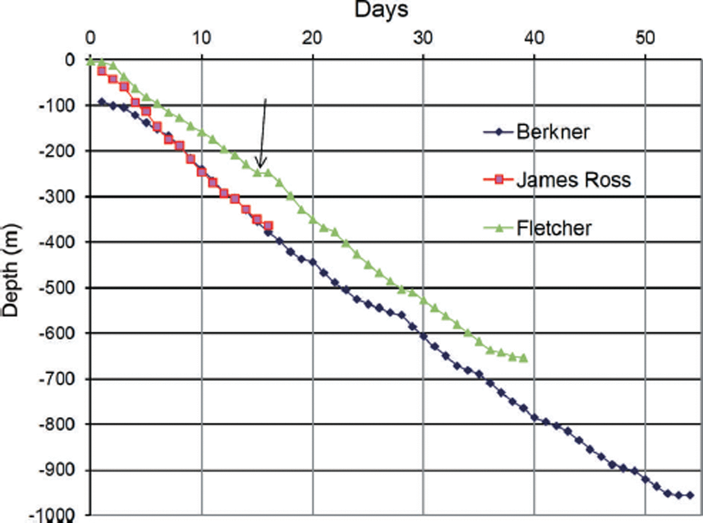
Fig. 8. Comparison of the drilling rates achieved during the three BAS/LGGE ice-core projects (Berkner here given from after the installation of the casing). The arrow marks the point where the Fletcher project changed from drilling 16 hours d−1 to a 24 hour d−1 drilling operation.
Table 2. Summary of the deployed infrastructure and drilling performance for the three intermediate-depth drilling projects
Acknowledgements
We are especially grateful to our colleagues in the field: Nerilie Abram, Susan Foord (deceased), Samantha Shelly, Louise Sime (JRI); Emily Capron, Romain Duphil, Louise Fleet, Emily Ludlow, Steve Stout (Fletcher Promontory). HMS Endurance provided logistical support for the JRI project, and we are grateful to the Captain, the Flight Team and the ship’s crew for their willingness and enthusiasm to support scientific endeavour. As ever, the BAS Operations and Logistics support from the Air Unit and all on station at Rothera were critical to our success. The two drilling projects were part of the BAS Polar Science for Planet Earth Programme, and were funded by the UK Natural Environment Research Council. Support from the Institut National des Sciences de l’Univers in France (INSU/PNEDC ‘AMANCAY’ project), facilitated by Jérôme Chappellaz and Françoise Vimeux, enabled the technical contribution of the French National Center for Drilling and Coring (C2FN – Ice).


