


Introduction
Highly-weathered bedrock terrain has been reported from scattered localities across Arctic Canada during the past decade. Examples have been correlated with both moraine and postglacial strand systems along both coasts of the Cumberland Peninsula on southern Baffin Island (Reference DykeDyke 1979 and Reference Dykeunpublished). Reference DykeDyke (1976) has also worked in parts of Somerset Island, and has observed that materials over much of the island consist of bedrock weathered in situ. Intensely-weathered Pre-Cambrian outcrops have also been noted from parts of the high Arctic including Devon Island (T. Frisch, personal communication), south-eastern Ellesmere Island near Cory Glacier (Reference BlakeBlake 1978[a]), Coburg Island (W. Blake Jr, personal communication), and around Lady Franklin Bay in north-eastern Ellesmere Island (Reference EnglandEngland, unpublished and Reference England and BradleyEngland and Bradley 1978). Their presence is now widely cited as evidence for limited late-Wisconsin glaciation and is apparently contributing to a re-evaluation of traditional margins of ice advance during the past 100 000 years. The purpose of this paper is to show that intensely-weathered terrain can be greatly influenced by lithology and basal ice conditions and is not solely a measure of length of exposure to subaerial weathering. The area of study is in east-central Ellesmere Island (Fig. 1).
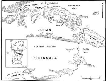
Fig. 1. Field study area.
Bedrock geology
Along the north-eastern part of the Johan Peninsula, including Cape Herschel and Pim Island, bedrock is typically massive, medium to coarse, equigranular to locally porphyritic and gneissic potassic granite (Reference ChristieChristie 1962). Widely-spaced-rectilinear joint sets and weak sheeting are present. Major lineaments are marked by steep slopes and straight cliffs particularly along the east side of Pim Island. To the north-west, between Cape Rutherford and the Royal Canadian Mounted Police station, the granite rocks grade into quartz-feldspar-biotite paragneisses with foliation trending at approximately N15˚E parallel to the Innuitian mobile belt. More mafic intrusions that include grano-diorite, diabase, and gabbro with localized gossan zones containing pyrite, magnetite, and copper sulphides are found along the south coast of Alexandra Fjord, on Skraeling Island, and more notably along the north coast of Alexandra Fjord.
The study area lies along the north flank of the Pre-Cambrian shield where early Palaeozoic dolomites, limestones, and sandstones crop out in steep s1opes and cliff faces that are up to 600 m high across Buchanan Bay to the north (Reference ChristieChristie 1967). Scattered outliers of Palaeozoic strata are preserved south-west of the RCMP post at widely-varying elevations ranging from with in 20 m of high tide to above 400 m a.s.l. and reflect considerable altitudinal variation in the Pre-Cambrian-Palaeozoic unconformity.
Surficial geology
Little information on the Wisconsin and Holocene history of this part of eastern Ellesmere Island has been collected. Intensely ice-sculptured granitic outcrops on the upland surfaces of Pim Island and Cape Herschel afford fresh, well-preserved glacial striations, grooves, chattermarks, and roches moutonnées that indicate movement from north to south along the western edge of the Kane Basin (Reference BlakeBlake 1977). Numerous erratics of Palaeozoic limestones and dolomites, mostly less than 200 mm in diameter, are found on upland surfaces. Fjord systems typify this part of eastern Ellesmere Island and attest to marked outlet glaciation with flow from the Ellesmere ice cap into the Kane Basin.
The numbers and distribution of Palaeozoic outliers in the region suggest that downward glacial erosion took place through softer sedimentary rocks into underlying foliated basement. Satellite imagery (e.g. image E–10255–18054, Band 7 – a mosaic) suggests that regional foliation had a strong influence on the orientation and extent of fjord development.
Lateral moraines were observed not only along modern valley glaciers (e.g. Leffert Glacier) but also on upland areas, e.g. above Alexandra Fjord halfway between the RCMP post and Cape Rutherford. One moraine ridge there is noteworthy in that boulders are weathered and show slight iron-oxide staining and surface pitting of feldspar; the ridge may be a remnant of an earlier Wisconsin glaciation.
The post-glacial emergence history of this region is currently being evaluated (Reference BlakeBlake 1977, Reference Blake1978[b]). Holocene marine deposits are found at 30 m a.s.l. east of the RCMP post and similar deposits on the mainland west of Cape Herschel are up to 90 m a.s.l. Marine shells from these beaches have been dated at 6.22 ± 0.140 ka (GSC–1348) (Reference Lowdon and BlakeLowdon and Blake 1973) and at 9 ka (GSC–25l6) (Reference BlakeBlake 1978[b]), respectively. Bedrock exposures below these elevations and presumably along the coast between these two sites have been inundated by sea-water in post- Wisconsin time and have subsequently undergone subaerial weathering.
Weathering features
Features typical of the intensely-weathered paragneisses along the south coast of Alexandra Fjord include grus, minor iron-oxide staining, tor-like forms, and minor weathering pits and tafoni. Both in upland ridge areas above 600 m a.s.l. and in places close to sea-level, residual grus accumulations were observed on exposed horizontal joint blocks and in sheltered joint systems. Disintegration of medium to coarse-grained quartz-feldspar-biotite gneisses by spalling of vertical joint blocks has yielded accumulations up to 300mm thick. The grus ranges from monomineralic grains 2 mm in diameter to polycrystalline fragments >l00 mm across. Calcium-carbonate coatings were noted on originally sheltered sides of individual spalled fragments. Examples of grus development were noted on upland surfaces above Cape Herschel, Some of these lay immediately adjacent to glacially polished, striated bedrock. The presence of grus both in glacially streamlined granitic outcrops and below levels of postglacial marine submergence implies recent development related to ge1ifraction. While locally more extensive, upland occurrences in well- drained ridge positions may not be as easily explained. Such features may have been at least partially developed and preserved beneath cold-based ice (cf. Reference Sugden, Waters and BrownSugden 1974, Reference Sugden1978). These accumulations closely resemble rotted surface rock found in more temperate, humid climates.
Tor-like features also are found in locations near sea-level and along upland ridges. Two distinct forms were observed, influenced by lithology and altitude. Near sea-level, west of Cape Rutherford, a major ridge provides numerous examples of large joint blocks developed in locally intruded, massive, medium-to coarse-grained gneiss (Fig.2). Individual joint blocks up to 5 m across and 3 m high have rounded corners but afford only limited horizontal jointing and sheeting. Block surfaces exhibit incipient iron-oxide staining and, in places, surface salt concentrations are present as thin white crusts. Enlarged vertical joint cracks up to 500mm across are partially filled with grus derived from surface spalling.

Fig. 2. Intensely-weathered quartz-feldspar-biotite hornblende gneiss at 15 to 20 m a.s.l. on the south coast of Alexandra Fjord 15 km east of the RCMP post. Well-defined rectilinear joint systems separate rounded joint blocks up to 3 m high. The notebook is 350 × 250 mm.
In spite of their topographic setting within 50 m of high tide, where valley glaciation along Alexandra Fjord must clearly have overridden the area, the tor-like forms lack evidence of glacial modification. Erratics and ice-rafted boulders are not common. Much of the weathering observed is the result of postglacial marine submergence, .emergence, and surface disintegration. At this site, weathering intensity is largely controlled by lithology (cf. Fig.3). Similar tor-like features have been observed in bedrock at Mesters Vig, north-eastern Greenland, below the upper limit of late-glacial advance, demonstrating the ability of recent processes to form them (Reference WashburnWashburn 1969).

Fig. 3. Contact between light-coloured granite (lower right) and quartz-feldspar-biotite hornblende gneiss at 40 m a.s.l. on the same outcrop as in Figure 2. Note the marked difference in physical weathering between the two lithologies. Spalling and cores tone development is evident in the paragneiss. A hammer serves as scale.
Similar features were noted in upland summit areas halfway between the RCMP post and Cape Rutherford at 830 m a.s.l. Here a large angular tor of garnetiferous quartz biotite. paragneiss occurs, which differs in form from other tors already described (Fig.4). This feature more closely conforms to a tor as defined by Reference CaineCaine (1967) as a “residual of bare bedrock, isolated by free faces on all sides, the result of differential weathering and mass slope wasting”. Slope retreat on the south side of this tor is especially marked but frost action has resulted in talus accumulation about its entire base. This form lacks any other evidence of chemical weathering or glacial erosion. Thus, the tors appear to be particularly well-developed in relatively massive crystalline rocks exhibiting widely-spaced rectilinear joint sets including some sheeting.
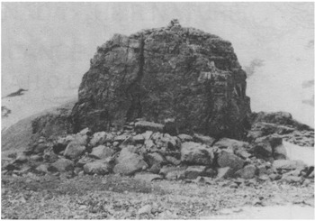
Fig. 4. A tor 5 m high developed in garnetiferous biotite gneiss at 830 m a.s.l. on a ridge crest west of Saate Glacier. Talus flanks the tor on all sides.
Weathering pits are not as numerous or as large as those found on the Cumberland Peninsula and on Baffin Island (Reference Sugden and WattsSugden and Watts 1977, Reference WattsWatts 1979). Larger examples were restricted to exposed flat-lying upland outcrop surfaces along the south coast of Alexandra Fjord (Fig.5). All observed examples lack overhanging edges and are interpreted as currently disintegrating. The largest pits measure 280 mm across and up to 80 mm deep, but most examples average 1ess than 100 mm across. The few weathering pits encountered appear to have formed by solution activity occurring over a very long time. Their form is not likely to survive glacial erosion. They are attributed to local, long-term preservation beneath cold-based ice (cf. Reference SugdenSugden 1978).

Fig. 5. Weathering pits in medium-to coarse-grained, locally garnetiferous quartz-plagioclase-hornblende gneiss at 300 m a.s.l., 5 km south-west of the RCMP post. The pits measuring up to 180 mm across and 60 mm deep reveal no preferred orientation.
Recent micropitting of glacially polished outcrop surfaces was recognized on Cape Herschel peninsula but this is apparently related to snow-patch melting on north-facing slopes (Reference WattsWatts 1981). Examples of tafoni developed on vertical joint faces in gneisses were noted at only three localities. These features measure up to 350 mm across, display no preferred orientation, and are also in a state of disintegration.
Bedrock geochemistry
Specimens were collected from 17 localities for chemical and petrographic examination. Chemical composition was determined by X-ray fluorescence procedures (Reference Norrish, Chappell and ZussmanNorrish and Chappell 1967). Analyses were performed in the Department of Geological Sciences, Queen's University, Kingston, Ontario, An attempt was made to correlate degree of surface weathering with variations in bedrock composition.
In Table I, 13 typical analyses, of the 40 originally run, are shown. Specimens are of either granitic or metasedimentary origin. The paragneisses compared to the granites are typified by relatively higher concentrations of iron, titanium, manganese, and phosphorus. The granites, in comparison, are more siliceous and contain more soda. Multiple analyses from single sites, however, indicate considerable local variability in bedrock composition which may be as great as the compositional range between the gneisses and granites as a whole. The higher iron and titanium contents reflect higher hornblende and iron oxides, suggesting that the most intensely-weathered outcrops in the region are the hornblende gneisses (e.g. 15/2). At this locality the paragneisses are intruded by alkali granite (e.g. 15/6), which is virtually un-weathered (Fig.3) and lacks titanium and iron oxides characteristic of the gneisses, Analyses of grus reveal no consistent chemical changes during disintegration.
Table I. Chemical Analyses of Major Ions in 13 Bedrock Surface Specimens Based on X-Ray Fluorescence Studies

Thin-section studies
Forty thin sections prepared from bedrock specimens and grus representing all phases of physical weathering were studied. Why are the gneisses so much more thoroughly weathered than the granites? Is the difference related solely to lithology or is it also influenced by either presence or absence of basal sliding of former glaciers or topographic position vis-a-vis sea-level? Both lithologies are medium-to coarse- grained with average grain sizes ranging from 0.5 to 2 mm. The granites have an equigranular to locally porphyroblastic texture. In contrast, the gneisses reveal interlocking grain boundaries which show deformation parallel to regional foliation. Mineralogically the former are composed of quartz and potassium-rich feldspars with only minor biotite present, while the latter comprise quartz, orthoclase, and plagioclase feldspars. biotite, and a variable hornblende content. Accessory minerals in both include pyrite and magnetite.
Particular emphasis was put on features characteristic of the intensely-weathered gneisses. Microfracturing is the most obvious petrographic feature noted (Fig.6) (cf.Reference BisdomBisdom 1967). Two types were recognized including incipient fracturing within individual grains and, in the extreme, development of subparallel microfracturing systems transgressing individual grain boundaries essentially parallel to outcrop surfaces. Some fractures are stained by iron oxides. A close correlation exists between abundance of hornblende and, to some extent, plagioclase, and the degree of bedrock weathering (cf. Watts 1979. Reference IsherwoodIsherwood, unpublished). Hornblende is a relatively unstable mineral (Reference GoldichGoldich 1938) and readily weathers to clay, chlorite. and vermiculite with an accompanying increase in volume favouring further microfracture development. I propose that such in-tense weathering is largely determined by the physical properties of hornblende which favour rapid deterioration of hornblende-rich rocks even under cold arid conditions. Hornblende occurs as subhedra1 to anhedral grains up to 10 mm across, averaging from 1 to 5 mm with good prismatic cleavage. Moreover, numerous inclusions of quartz up to 1 mm across are common. Microfracturing is particularly common as subparallel cracks developed at right angles to cleavage in hornblende as well as plagioclase. Grus accumulations tend to be thickest, up to 300 mm, on hornblende-rich gneisses. Surface weathering on granitic terrain is restricted to edges of joint systems and to contacts of quartz veins where moisture has been able to concentrate and induce cracking through ge1ifraction (cf. Reference PottsPotts 1970). Microfracturing is also favoured by the medium-to coarse-grained texture of the gneisses wherein expansion of individual mineral grains can effect disintegration. Under hot arid conditions in Australia penetration of moisture has similarly led to flaking and tafoni development (Reference DragovichDragovich 1967). Repeated hydration and dehydration with crystallization of the NaCl and NaS04 in rock pores can also contribute to rock disintegration (Reference JohnstonJohnston 1973). Only minor mineral expansion related to hydration along basal cleavage in biotite was observed during the present study. Weathering of accessory pyrite has imparted a rusty appearance to outcrop surfaces in the gneisses at two localities.
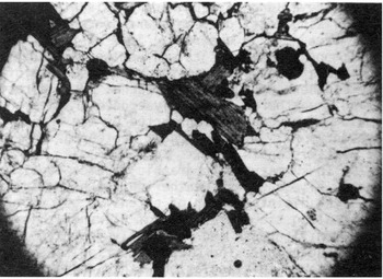
Fig. 6. Thin-section view of microfracturing of hornblende and plagioclase in gneiss from outcrop shown in Figure 2. Minor iron-oxide staining is evident in otherwise unaltered bedrock. Field of view is 2 4 mm across.
Intensely-weathered hornblende-rich erratics revealing marked granular disintegration and flaking related to moisture concentration were occasionally observed. Some of these reveal good examples of tafoni weathering. One such erratic observed on the upland surface of the southern part of Cape Herschel rests directly on unweathered, glacially eroded granite and could not have been transported by ice in its present form. It has largely weathered in situ in post-Wisconsin time.
In summary, petrographic studies confirm that, while chemical weathering has been minimal, physical disintegration of extensive outcrop areas along the south coast of Alexandra Fjord has been vigorous and is largely dependent on microfracturing. The microfracturing has been most intense in association with cleavage in hornblende and plagioclase.
Conclusions
-
A variety of weathering features occur both near sea-level and on upland areas along the south coast of Alexandra Fjord in centra1- eastern Ellesmere Island.
-
Lowland examples strongly suggest that tors are not always indicative of areas which have not been glaciated and that they cannot be used to indicate ice-free areas during Wisconsin time.
-
Upland weathered surfaces, which appear to be older in type and degree of development, show that intensity of glacial erosion (i .e. basal ice conditions) varied markedly over relatively short distances both inland from the coast and up-slope from fjords.
-
Field observations, chemical analyses, and petrographic studies indicate that in this region lithology and specifically hornblende content is a dominant factor influencing intensity of weathering.
-
A considerable volume of cold-based glacial ice apparently flowed south out of the Kane Basin across the eastern part of the Johan Peninsula at some stage. As the ice passed up out of the basin, compression and intense erosion resulted in the intensely ice-sculptured terrain of Cape Herschel and Pim Island. Southward flow from the Kane Basin inhibited ice flow from the west and thereby minimized upland glacial erosion along Alexandra Fjordo. This favoured preservation of upland weathering features.
Acknowledgements
I wish to thank the Polar Continental Shelf Project (Dr G. Hobson, Director) for air transport to and within the study area during the 1979 field season. Dr Wes Blake Jr, Terrane Sciences, Geological Survey of Canada, offered both direction and encouragement in proposing that I visit his current field area to study weathering processes and extended generous hospitality at Cape Herschel. Mr F. Dunphy, Department of Geological Sciences, Queen's University, carried out the X-ray fluorescence analyses. I am indebted to Dr T. Feininger and Dr D. Sugden for their helpful comments and suggestions in reviewing an earlier draft of this paper. This study would not have been possible without financial support from the Department of Energy, Mines and Resources, Canada (Research Agreement 53–4–79), to whom I am deeply appreciative. Field facilities at Alexandra Fjord and at Cape Herschel were provided by the Royal Canadian Mounted Police and the North Water Project.


