

Is the Earth an island floating in space? The category of ‘islands’ may seem well defined in geographical terms, yet they are good illustrations of the matryoshka principle. Isolate an island and you quickly find that its status as an island is set in a sequence of other relations. First, islands are often defined from mainland territories, and, in our contemporary world, from states such as Australia or China. These mainland territories can themselves act as islands, or even create empires of islands. Second, most islands sit within archipelagos. For Indigenous peoples, collections of islands count as the centre of the world, ‘seas of islands’, rather than ‘islands in a far sea’. This is to borrow the memorable rendition of Epeli Hau‘ofa, one the greatest theorists of island cultures who sought to invert the colonial distancing of islands.Footnote 1 While Hau‘ofa was describing Pacific islands, his point may also apply to the Maldives or the Andaman islands. Third, the status of being islanded is defined against the globe itself. An island is so because it is surrounded by the waters of the World Ocean and is often conceived of as encircled, for instance, from the deck of a ship in the early modern period, or from the air in our times.
The scientific conjurer may wish to create the perfectly exposed and insulated island, ideal in every way for observation, experimentation and theorization. Yet, given the matryoshka principle, as soon as such an island is located it disappears in a sequence of spatial entanglements, oppositions and imprecisions. It is because islands occupy this conflicted relation that they became such important sites for the creation of modern science as a universal fact and also as knowledge which can scale the local to the global. The island, the archipelago, the continent and the globe easily create a bridgeable sequence for knowledge makers. The islands of the Indo-Pacific are among the most marginalized sites of modern historiography, but since they have been used to scale up and make science, it is important to place them at the heart of the history of science. Yet, simultaneously, it is also critical to deconstruct this view of the island, as laboratory, archive and field, and to place the islands of the Indo-Pacific and their various knowledge traditions in a much more variegated and plural history. It is necessary to see these islands as alive with knowledge rather than as the empty and dead ends of the world as theorists in the past saw them.Footnote 2
A telling example tied to the charting of the shape of the Earth points to how islands have been used by colonial scientific practitioners for their isolation, while also operating within spatial heterodoxies over which such practitioners are either ignorant or without control. In the 1820s, John Goldingham of the Madras Observatory wished to find a perfect island in the Indian Ocean, close to the Equator and away from the gravitational pull of mountains in order to determine the precise shape of the Earth by repeatedly measuring the time it took a pendulum to swing.Footnote 3 The expedition he organized, with the support of Stamford Raffles, found an island which it thought suitable. ‘Gaunsah Lout’ (probably Gangsa Laut), close to today's Pulau Pini, off-island Sumatra, was the choice. Dubbed ‘experiment island’, this was an island ‘365 feet long by 200 feet broad’. One illustration shows the party of investigators on this ideal island: four Europeans in hats gesticulating and making plans before a line of white tents. However, islands are not often reached alone: in the background are a set of Asian assistants who are clothed in blue, probably Asian lascar sailors (Figure 1).
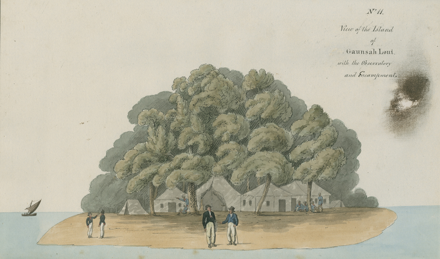
Figure 1. ‘View of the Island of Gaunsah Lout with the Observatory and Encampments’, in John Goldingham, Report of the Length of the Pendulum at the Equator (Madras: Madras Observatory, 1824), Image no IRS. 10694, © Royal Society.
The inhabitants of the Indo-Pacific world made their presence felt in another way. Within the expedition, there was the fear of attack by the Padri movement, an accelerated programme of religious reform in West Sumatra, an attempt to cleanse Islam of adat or local customary law. The expedition was provided with a guard. But the terrain of the Indo-Pacific made the greatest mark on this expedition. An earthquake provided an alarming shock to the travellers while they were at Bengkulu, a severe squall overtook them after leaving Bengkulu, and a further series of tremors struck the expedition as they travelled through islands and settlements off Sumatra in search of their island for the experiments. On one occasion at Pagang Island, ‘a shock of an Earthquake was felt, which is stated to have given the earth, an undulatory motion for some minutes – another (but slighter) shock was felt shortly afterwards’.
The image of Goldingham's agents watching the mass of a pendulum swing on an island surrounded by the sea, in turn to find the shape of the Earth and to make its misshapen form more manageably spherical for ships in need of location data, gets to the precise spatial entanglements that deserve note. The island sits in a series of spaces rather than alone: Gangsa Laut itself sat where tectonic plates met, where the Earth bulged and where Islam was being reformed, and on it were the experimenters with their baubles. Yet over and over again the attraction for scientists of ‘islands’, and of Gangsa Laut too, lies in their insularity and boundedness and the potential to make islands self-contained laboratories for the making of the global and universal. The contributors to this special issue admirably demonstrate that Goldingham's quest is not exceptional among colonial scientists.
Observation is intensified on islands by their spatial heterodoxy: note, for instance, the flights of fancy undertaken by Charles Meldrum in Mauritius, who moved between the sensations and the instruments and through the terrain of the island itself in order to master a storm, as described by Mahony. The island is a constellation of worlds in a bounded space: note the ‘mediator of mediators’ Georg Everhard Rumphius, as described by Yoo, as he navigated the Ambonese world and its stratified and multiple networks of information and material culture, never translating in one direction alone but moving between different orders, nationalities and forms of status making. Also, as Parker reminds us, the island is never only or just a physical or geographical site in the history of science: note the recurrence of ‘chimeric’ Pepys Island and its popularization and how island obsession sustained imperial ambition in the Pacific until this fable was reduced quite literally to the mist on the ocean.
If colonial science works by seeking the isolated site that can be manipulated by those watchers of time and space, this collection of essays critiques and displaces such a vision. It does so by insisting on the importance of non-Western perspectives in the history of science, and also on the broader need to keep in sight alternative visions, geographic, natural and cosmological, in understanding the status of islands in the history of science. Island societies have rich histories of long-term mobility consistent with their high biodiversity at the bridge of sea and land; the colonial obsession with race, gender and classification followed these histories. Bil carefully illustrates the process through which this occurs: Māori plant names were turned into a colonial ‘currency’, whereby their use marked the attainment of colonial theorists of ethnology and racial science, but not the epistemological treasures at the heart of the botanical knowledge of Indigenous peoples. The names became ‘bare numerical data’. But if we are to deconstruct such colonial knowledge making, the histories of richer tapestries of interchange across the seas of the Indo-Pacific are just waiting to be found. We believe that this, indeed, is one of the crucial avenues for further exploration that this collection of essays opens up.
Historians have been interested in foregrounding Indigenous and subaltern histories of science for some time.Footnote 4 And yet, as these essays show, the challenges for such exploration remain formidable. The discipline's epistemological boundaries stubbornly follow the divide between the study of, on the one hand, what were seen in the past to be other cultures and, on the other, Western explorations of a naturalized material world that is supposedly only really accessible through scientific practices. This is why, in spite of decades of post-colonial, subaltern-centred scholarship, histories of knowledge-making practices that go beyond imperial and colonial boundaries remain, by and large, still in initial development. This is not only the result of the supposed paucity of the archival materials available for exploring such histories, and the lack of languages on the part of historians, but also because of the unquestioning commitment of historians to the original categories and episteme which hived off the history of science from anthropology or imperial history, and later non-European history and area studies.Footnote 5 Islands, as much as they have figured prominently in the imagination of these foundational epistemologies, also offer rich possibilities for their disruption. For they have not easily fitted into the disciplinary rubrics of the humanities and social sciences more generally.
The fact that Māori plant names became ‘increasingly univalent signifiers of obsolescence and otherness’ (Bil, this issue) has, to be sure, a long history. Even if, during the sixteenth century, Europeans voraciously aimed to gather indigenous knowledge about the natural world through the use of humanistic practices, practices that resulted in the production of vaunted compilations such as the Florentine Codex in New Spain, these efforts at engaging non-European knowledge as descriptive of natural truths were mostly abandoned by the end of the seventeenth century. Borrowing from their experiences in the New World, and prominently in the Caribbean, Europeans reimagined islands in other places as locales for experimentation and exploitation. Furthermore, it has been on the basis of such notions about islands and their epistemic import – ideas imagined elsewhere – that some historians have conceived of the historical and historiographical tools to analyse the Indo-Pacific worlds. As Bil's recounting of the history of Māori indigenous plant names reminds us, Western processes of categorization and epistemological construction created in the early modern period in the Atlantic – in this case Alexander von Humboldt's ideas about the inverse relationship between exuberant nature and civilization – remained crucial in Europeans’ construction of the very concepts of Indian and Pacific aqueous worlds. Indeed, a multitude of similar boundary objects, and categories, had been in circulation in the Atlantic and Pacific doing the same work of concealing indigenous ways of knowing for several centuries before Humboldt. The idea of the modern, naturalized island and its primitive colonial inhabitants that sprout out of Atlantic encounters has also played an essential role in the ways that historians examine islands elsewhere.
If the histories of the entanglements of the Atlantic with the Indo-Pacific are not linear or teleological, then the relations between the Indian and Pacific Oceans themselves are complex. Europeans saw places in the Americas such as New Spain and Peru as crowded, with very different forms of religious and political culture. Yet by the beginning of the seventeenth century they already understood the islands of the Caribbean to be depopulated of their original inhabitants and ripe for scientific exploration and commercial exploitation. They also saw most of the Indian and Pacific Oceans as full of just specks of land and sometimes with no people at all, and if with people then not with Indigenous peoples who were sovereign over their land. If Europeans defined the Atlantic Ocean, but not the Indian and Pacific Oceans, which had long histories of exchange prior to Europe, it is powerful, then, to place these two oceans together as this special issue does. Having done so, there is merit in reflecting back on how these histories intersect with that of the Atlantic and particularly those of the Caribbean.
Beyond the colonial programme of creating islands as laboratories, archives and fields, the intellectual sequencing of the islands examined in these essays might look utterly different. Note how liberating it is to track the nutmeg as it moves from the Maluku islands to what is now Mauritius in Brixius's paper. Here Malagasy and African ethnobotanical knowledge, as well as South East Asian and European understandings, had to be pieced together in order to create a successful pattern of cultivation. In this geography, Europe is not only decentred; rather it is possible to move across the wide seas with materials and cultures in transit, but also in need of transplantation rather than easy copy and paste. Such a perspective certainly displaces a mechanistic view of the workings of globalization or imperial science by insisting on both long-distance and local factors in the making of an organic and tightly braided assembly of knowledge. The island now becomes not a cipher in a global model, where the Earth can be gazed at from the aqueous space above it. Rather this is a grounded history of different complexes, human and non-human, indigenous and migratory. It takes both the south-east and the south-west Indian Ocean seriously.
Global or world history, as practised not only by historians of science but also by other historians, is often taken to be a programme of connections and comparisons, including the study of how knowledge moves and circulates.Footnote 6 Such an agenda has been central, too, to writings on non-European systems of knowledge production. Analytical frameworks that follow the imagined and universalizing idea of global connectivity, another common trope emerging out of the early modern world and also from high modern empire's technologies, can by default serve as the central space for the integration of non-European histories of knowledge into histories of science. The essays in this issue demonstrate that Indo-Pacific islands were, however, more than links in imperial networks of knowledge production and flow. As Mahony's essay, for instance, shows, histories of islands can be fruitful spaces for studies that emphasize isolation and disruption. The history of Pepys Island and its maps, as discussed by Parker, also underscores the importance of recognizing the fractiousness, mundanity, provinciality and contentiousness of the seemingly teleological European models that drove the cartographic imagination of the globalizing (and universalizing) historical category of the island. Brixius keeps reminding the reader that the transference of knowledge across the Indian Ocean was incomplete. The very materiality of the Isle de France did not allow simply circulation. As she writes (this issue), ‘When knowledge does not travel, productive innovations become possible’.
Indo-Pacific islands and their aqueous surroundings were (and can be) intensely unsettling. They demand a different sort of analytical engagement rather than the global as universal, for these island histories can be profoundly illuminating. How does one, for instance, study histories of transfers of knowledge within interregional spaces like between the Maluku islands and the Isle de France – histories that do not travel through the usual channels, or depend on the categories and actors that historians of the West use to classify them? Rethinking the aqueous spaces of the Indo-Pacific world as linkages that do not follow European routes, rather than ruptures that diffract the numerous island spaces of the Indo-Pacific world, allows for the ideation of different wholes, and relationalities. Seemingly fragmented and isolated island spaces can then be seen as departing points for the imagination of histories, geographies and temporalities of different kinds that do not depend on Western historicism. For islands and aqueous zones have not only drawn colonial observers to consider origins and futures, the human and the non-human; the cosmological understandings of islanders hold within them orders of knowledge about nature, the body, the sea and land; they range across elements and across very different modes of belief, prophecy and ritual. This is why words such as ‘cosmopolitan’, ‘hybrid’ or ‘creole’ are coming under increasing fire for being unable to describe the richness of this world.
Maybe the answer lies less, then, in thinking about these worlds in terms of histories of normative science, than in recognizing that the very material practices and knowledges they offer us cannot be contained within the now far too traditional global connected histories into which we insist on inserting them. The protective rings of the Giri (the ones that Rumphius described in the tradition of the fetish), for instance, functioned within their societies on the basis of their power to create value – social, political and economic – in the same way that the tools of contemporary natural philosophers and, later, scientists did in European societies. As Yoo notes, however, there was nothing that circulated about their power to work in the world, or the knowledge to craft them. If historians of science and technology want to adequately address the calls for diversifying a field dominated still by Euro-American epistemological frameworks, then we need to start taking seriously historical actors and their engagement with material life and life inscribed in a natural world defined in their own terms.
The history of the Indo-Pacific brings into relief the limitations of models of history that have relied on the imagination of islands as engines of modernity. It is easy to dismiss as strident claims about the importance of studying the tools and knowledge-making process of peoples outside the vaunted nodes of circulation of knowledge of natural historians and natural philosophers and their scientific heirs. Yet by ignoring the history of Malagasy knowledge about plants, or the material power of Polynesian protective rings, we risk being wilfully blind to the very material means that drove processes of knowledge making related to the natural world in most historical spaces (independent of whether or not they appear to be ‘global’). In searching for cultural clues about the ideas and beliefs enacted by people like the Giri, or how they fit with existing historicist models, we risk ignoring that what is really talked about is forgotten, for crucial modes and currencies of material transaction have become ephemeral. Meanwhile, as Bil notes, the end point of a lack of appreciation of Māori phytonyms is ominous: the dispossession of Māori from their land and resources.
It is for this reason that another image to that of Goldingham's attempt at mapping the Earth is necessary to conclude these thoughts. Let's stick with the vast ‘sea of islands’ that constituted the site of this experiment. Here is a Bugis nautical chart, with Muslim era date AH 1231, which is 1816 CE (Figure 2). It is made of cowhide, is marked in green and red ink, and is of a rare set.Footnote 7 It records both sea depths and place names, as also Dutch places of colonization with flags. It even shows a small section of the coast of Australia, as also the Andaman and Nicobar islands. The fact that the maritime fringe is here presented in heavy and exaggerated detail indicates how the Bugis navigators – some of the most famed navigators of the Malay world – used the terrain and mountains marked here to navigate. Though this is certainly a Bugis map, it is also a map that shows interaction with Europe and one possible theory is that its form is influenced by a map of the region drawn by a French captain, d'Aprés de Mannevillette. The ephemeral archive for Bugis navigation of the islands of South East Asia is not an excuse to exclude sources like this from the history of science; at the same time working out how this map was made and used is not an exercise in the creation of a curious other, nor indeed of an authentic indigenous. But it is an exercise that is urgent if we are to displace the aggressively colonial foundations at the heart of the discipline and to reconsider Bugis pathways and other Indigenous pathways across hosts of islands as embodied knowledge. This knowledge is neither pure nor isolated, but organic, changeable and tightly woven around a variety of forms, practices and lineages. It will take us in a different direction to the historiography of colonial science, or even global histories of science interpreted as universal narratives, and also a different path to histories of connection. It is this invitation that the authors of these essays lay before historians of science.
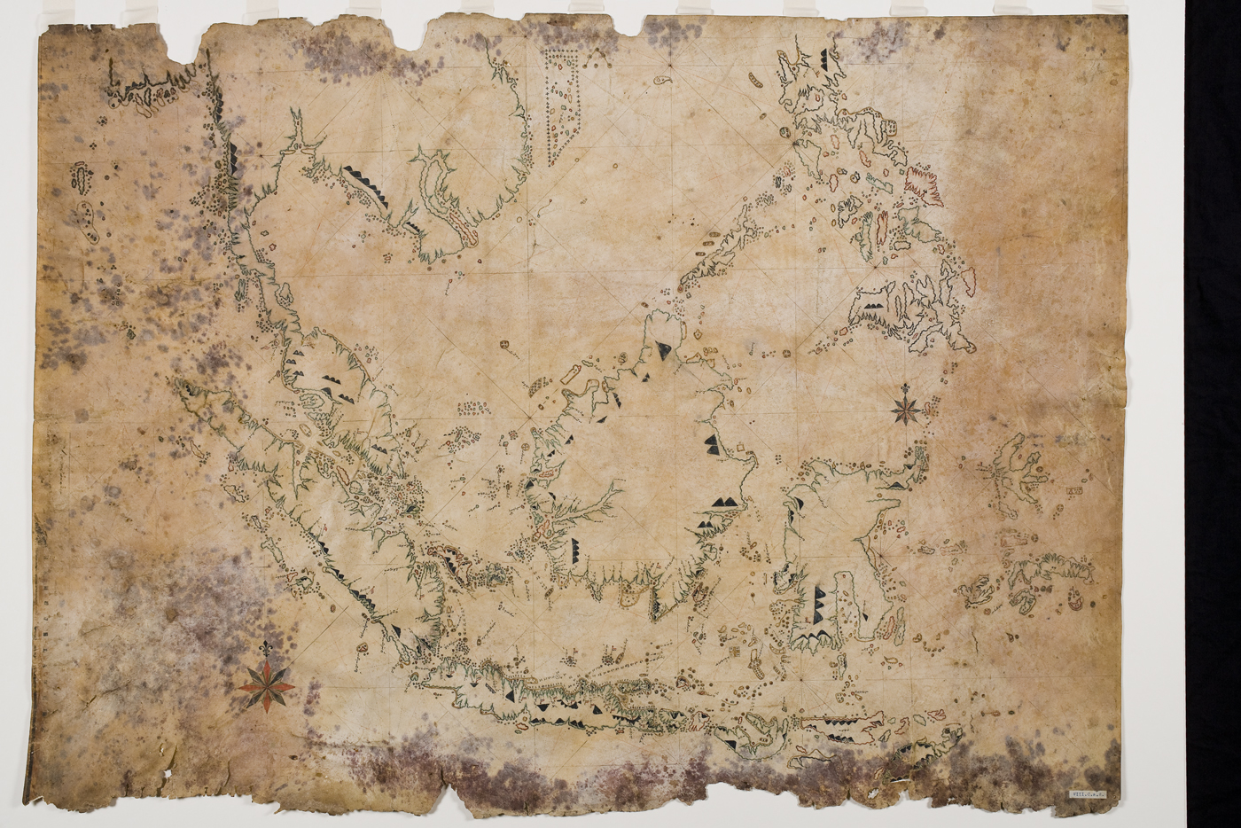
Figure 2. Bugis nautical map on cowhide, AH 1231, c.1816, Kaart: VIII.C.a.2, Special Collections, Utrecht University Library.


