Introduction
Recent surveys by Sevink & Den Haan (Reference Sevink and Den Haan2012) and Den Haan & Sevink (Reference Den Haan and Sevink2014) of the Monnikenberg estate (Figs 1, 2), to the SW of the Groot Wasmeer, east of Hilversum (the Netherlands), showed that its small pool (the Monnikenven) is man-made. It is situated in a former mire, with a predominantly peaty fill developed on a stagnative podzol. This fill had been drastically affected by the building of the estate around 1840, which included the creation of the current Monnikenven, but in places the original fill seemed to be well conserved, notably in the southern border zone where more recent drift sands acted as protective cover (Fig. 3).

Fig. 1. The location of the Monnikenberg estate.

Fig. 2. The current Monnikenberg mire with the coring locations and extension of the stagnative layer (in red). Locations of Monnikenven-1 (M1) and Monnikenven-2 (M2) indicated with *.

Fig. 3. (A) Thickness of the peat fill within the area with stagnative layer. (B) Altitude of the top of the stagnative layer (m + NAP).
In some corings, this fill was over 1 m thick and included well-developed peat layers, potentially allowing for more detailed insight into the genesis and history of the area. In the border zone, the organic fill was overlain by yellowish drift sand. A core in that zone was studied for its pollen and other microfossils contents (for location and diagram ‘Monnikenven-1’, see Fig. 2; Fig. 5, further below). Based on radiocarbon dating of selected above-ground plant remains, the lower part of the fill at this site dated from around 1900 cal BC, while higher up ages of AD 0–400 cal were obtained (Table 1). As well as the reversal in time of the two upper radiocarbon dates, there was another chronological problem: the peat in the upper 50 cm of the studied core appeared to contain pollen of cornflower (Centaurea cyanus) and buckwheat (Fagopyrum). Cornflower is a plant species that first occurred in the Netherlands during the High Middle Ages (Pals & Van Geel, Reference Pals and Van Geel1976; Bakels, Reference Bakels2012); buckwheat pollen grains have been continuously present only since the Late Middle Ages (De Klerk et al., Reference De Klerk, Couwenberg and Joosten2015). Evidently, the presence of pollen from these two species is inconsistent with the radiocarbon ages. A tentative explanation might be that people exploited peat for fuel in the Late Middle Ages or Early Modern Times, thereby disturbing the fill, but historical records of such activities do not exist.
Table 1. Radiocarbon dates of selected above-ground plant remains.

Calibration by OxCal v4.24 (Bronk Ramsey, Reference Bronk Ramsey2013); IntCal13 (Reimer et al, Reference Reimer, Bard, Bayliss, Beck, Blackwell, Ramsey, Buck, Cheng, Edwards, Friedrich, Grootes, Guilderson, Haflidason, Hajdas, Hatté, Heaton, Hoffmann, Hogg, Hughen, Kaiser, Kromer, Manning, Niu, Reimer, Richards, Scott, Southon, Staff, Turney and Van der Plicht2013).
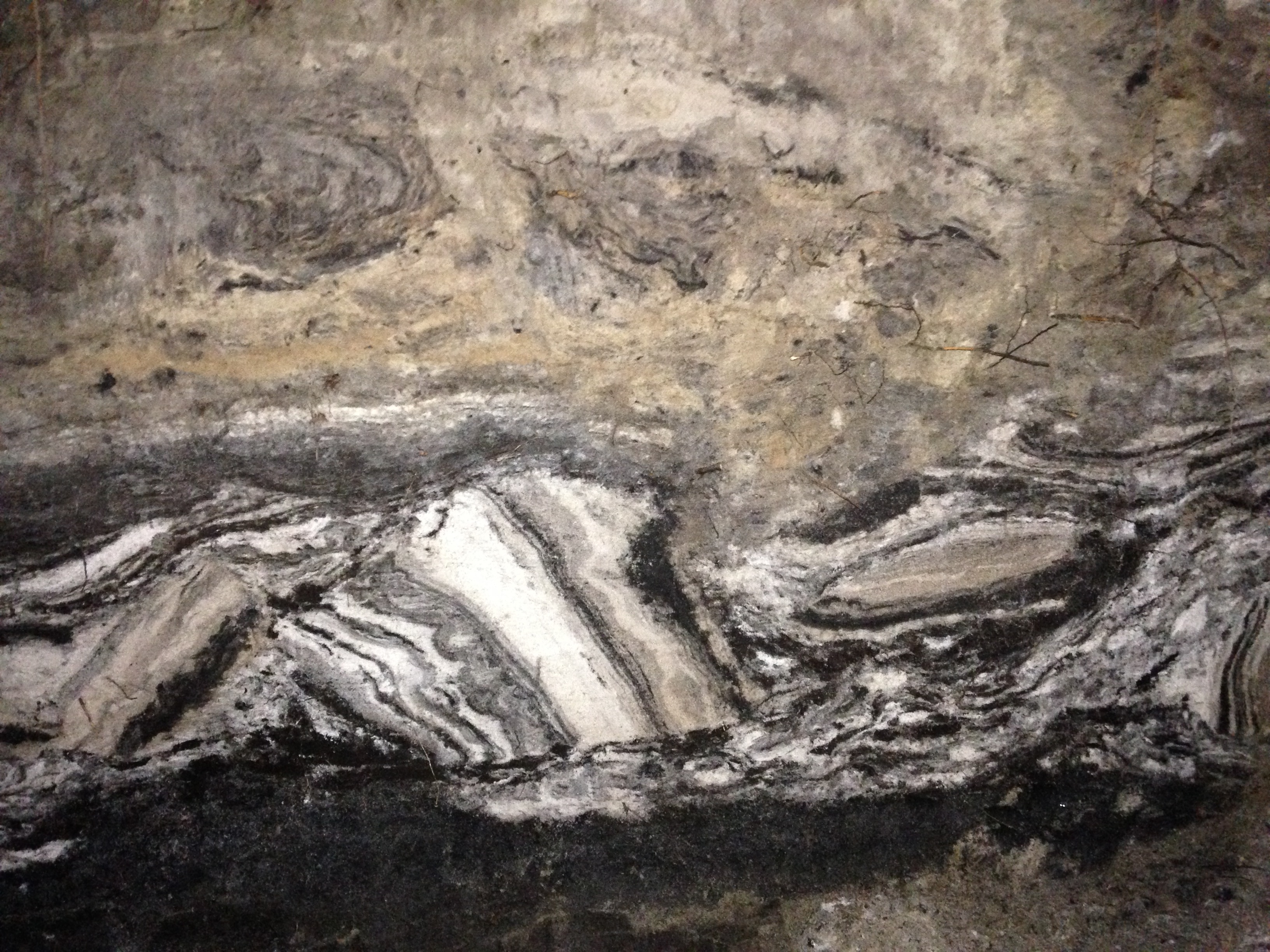
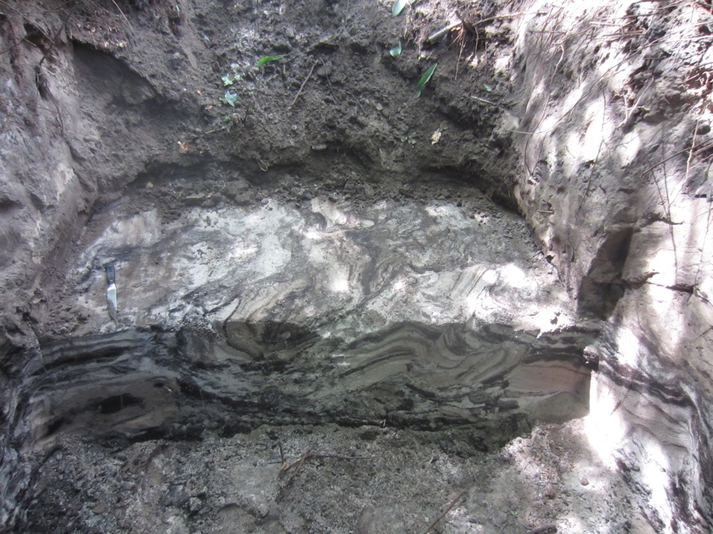
To allow for more detailed observations and sampling of the fill, a large pit was dug in the southern border zone where the drift-sand cover was known to be up to 1 m thick. In this pit (Monnikenven-2; Fig. 2), very unusual chaotically stratified sedimentary structures were observed between the underlying stagnative podzol and the overlying more yellowish drift sand. These structures would not have been properly understood in cores, and resembled phenomena that in places had been observed in sections in the Groot Wasmeer border zone (Fig. 4). In the present paper, we describe these sedimentary structures (Fig. 4). Furthermore, we present radiocarbon datings and microfossil analyses, which served to reconstruct the age and origin of the various sediments and structures. Lastly, we briefly discuss the implications of our results for the ongoing discussion on the origin and age of the Dutch heathlands and drift sands.

Fig. 4. (A) The rare sediment structures in the pit Monnikenberg-2. (B) Sedimentary structure from the southern border zone of the Groot Wasmeer.
Setting
Today, the Monnikenven is a small shallow pool in a former mire. The current water level of the pool is at maximum around 320 cm + NAP (Dutch Ordnance Datum), but commonly between 270 and 290 cm + NAP, while the top of the stagnative layer is mostly between 200 and 250 cm + NAP, with some deeper parts (to about 170 cm + NAP). The latter depth is more or less equal to the current mean highest groundwater level (GHG), which lies at about 180 cm + NAP. This is considerably lower than the maximum groundwater level that existed in the nearby Laarder Wasmeren area around 3000 BC (230 cm + NAP: Sevink et al., Reference Sevink, Koster, Van Geel and Wallinga2013), and thus deeper parts of the mire were likely submerged at that time.
The current topography of the parcel in which the Monnikenven is located dates back to the mid-19th century. At that time, its higher sandy parts were levelled and the excavated podzolic material was used to fill in the lower parts, resulting in a more or less level field with a small pool (the current Monnikenven) and, adjacent to that, a low artificial hill. In its southern border zone, forest was planted with beech (Fagus sylvatica) as the major tree species (Den Haan & Sevink, Reference Den Haan and Sevink2014).
To the NW of the Monnikenven, a similar large lake occurs (the Groot Wasmeer) that holds a complex of white sands with some thin intercalated peaty layers (Sevink et al., Reference Sevink, Koster, Van Geel and Wallinga2013). This lake also formed by water stagnation on a dense podzol. The sands in its border zone are of aeolian origin, but were deposited in a marshy environment, acquiring their bleached colour by post-depositional reduction, like the bleached sands in the Monnikenven mire. Aeolian deposition in this border zone was found to have started around 400 BC (optically stimulated luminescence (OSL) dating), an intercalated peat layer dated to around 2000 years ago (14C dating), and the transition from bleached white sands to overlying yellow, terrestrial drift sands was dated at around AD 1400 by OSL (Sevink et al., Reference Sevink, Koster, Van Geel and Wallinga2013). The sequence resembles that observed in corings in the nearby Monnikenven.
Early maps suggest that the Groot Wasmeer lake was at least partly filled with more or less organic sediment. However, during a sanitation operation at the beginning of the 21st century, when the lake was completely drained (Sevink et al., Reference Sevink, Vlaming, Van den Berg, Khodabux, Landsmeer and Stoeten2008, Reference Sevink, Siebelink, Strijbis and De Haan2012), in its central part such sedimentary fill appeared to be virtually non-existent. This eventually might be attributed to earlier extraction of peat, since such extraction is known from early historical records for Het Gooi (Borger, Reference Borger and Verhoeven1992), but there is no historical evidence for such practice in this part of the region. The absence of a fill may also be due to later human activities, including the massive dredging of sand from a deep pit in the centre of the lake in the 20th century. Whatever the causes were, they prevented a detailed study of the earlier history and formation of this lake, and its surroundings, and prompted us to study the Monnikenven fill in more detail.
Materials and methods
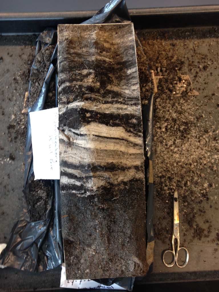
The southern maximum extension of the mire is indicated in Figure 2. Here the predominantly organic fill is covered by drift sand, the thickness of which increases to the south. Locations of the core (Monnikenven-1) and of the pit (Monnikenven-2) are indicated in Figure 2, and their lithological descriptions are presented in Table 2. The pit measured 1.5 m × 3 m and had a maximum depth of about 120 cm, groundwater being present at that depth (about 280 cm + NAP, 25 July, 2015). Plastic peel monoliths of its faces were made for detailed sedimentary facies study (see Fig. 4).
Table 2. Description of sections sampled.

The description of Monnikenven-2 refers to the section shown in Figure 4A. 14C samples were taken from this section (74–82 cm) and from the monolith taken for microfossil analysis (98–101 cm: thin peat layer; 107–110 cm: peaty topsoil of undisturbed podzol).
Samples were collected for microfossil analysis from the core (Monnikenven-1) and from a large monolith taken from the face of the pit (Monnikenven-2). For the analysis, subsamples of c. 1 cm3 were treated with KOH and subsequently acetolysed according to Fægri et al. (Reference Fægri, Iversen, Kaland and Krzywinski1989). For the separation of organic material from mineral particles, a bromoform–ethanol mixture (specific gravity 2) was used. The microfossils were embedded in glycerine jelly, and microscope slides were sealed with paraffin. Pollen was identified using Beug (Reference Beug2004), Moore et al. (Reference Moore, Webb and Collinson1991) and a pollen reference collection. Non-pollen palynomorphs were identified according to Van Geel (Reference Van Geel1978) and Van Geel & Aptroot (Reference Van Geel and Aptroot2006).
Samples for radiocarbon dating were taken from both the core (M1) and the pit (M2). They were treated with KOH, after which botanical above-ground macrofossils were handpicked from the sieve fraction >160 µm (charred and non-charred plant remains of ericaceous species including twigs, seeds and flowers). The samples were washed and dried. AMS radiocarbon dating was carried out at the Centre for Isotope Research, Groningen University. Samples were pre-treated following the standard procedure (A-B-A). The dry weight of all samples was more than 10 mg and therefore sufficient for 14C AMS dating. The results were reported in conventional radiocarbon years, corrected for isotopic fractionation using the stable isotope ratio ∂13C, and the conventional half-life (Mook & Van der Plicht, Reference Mook and Van der Plicht1999).
In the text, 14C dates are reported in years cal BC or cal AD (Table 1) and OSL dates as years BC or AD, and not as years BP, to prevent confusion resulting from the differences between reference years used for 14C dating (1950) and OSL dating (year of analysis), and true calendar years.
Results and discussion
Sediments and radiocarbon ages
The Monnikenven-1 core consisted of non-stratified yellow drift sand over about 70 cm peat/white-sand complex resting on a humic podzol. The latter probably developed in coversand. The radiocarbon ages (Table 1) point to an onset of sedimentation on top of the podzol (at about 210–225 cm + NAP) at the beginning of the second millennium BC and a start of the massive drift sand deposition in a terrestrial environment around the beginning of the 1st millennium AD, similar to the results for the Groot Wasmeer.
In the Monnikenven-2 pit, the peat/white-sand complex appeared to be composed of chaotically stratified sediment, covering a podzol with an intact, well-conserved peaty O/H horizon (see Fig. 4). Upward, this chaotic deposit grades into a thin layer of more yellowish sandy sediment with vague horizontal stratification and some fine, humic layers. This again is covered by 70–80 cm of a mixture of irregular yellow to slightly humic (darker) large ‘soil fragments’, indicating that the original soil had been deeply worked (deep Ap horizon) prior to the planting of the beech trees, which are about 150 years old. The latter is fully in line with observations by Den Haan & Sevink (Reference Den Haan and Sevink2014), who found that throughout the estate the soil had been worked to a depth of 80–90 cm.
Most remarkable is the chaotically stratified peat/white-sand complex, composed of a highly irregular three-dimensional ‘mosaic’ of mostly angular blocks of stacked white sand and peaty layers. Individual blocks vary in size from a few centimetres to several decimetres and lack a preferred orientation, but the southern face of the pit showed a rather horizontal stratification. A monolith used for screening microfossils was taken from this face. It exhibited a less chaotic stratification and a distinct peat layer, sampled for 14C dating (98–102 cm).
Plant remains from the O/H horizon of the underlying podzol (charred and non-charred plant remains of ericaceous species) were radiocarbon-dated to the early 3rd millennium BC and from the peat layer from the southern face (monolith) at around 2000 BC (samples GrA-64745 and GrA-64746 respectively; see Table 1). The more or less horizontally bedded sands above contained very few non-carbonised plant remains other than roots, and the radiocarbon-dated sample therefore concerns carbonised plant remains, which date from the onset of the 1st century BC (74–82 cm; GrA-64809).
Pollen, other microfossils and radiocarbon dating
The microfossil diagram ‘Monnikenven-1’ is presented in Figure 5. Taxa starting with Alnus up to Spergula arvensis were included in the pollen sum. The exaggeration factor of the pollen curves is 10×. Three zones can be distinguished. Zone A (the lower six samples) is characterised by an initially low concentration of pollen (high values of added Lycopodium spores) and local taxa such as Lycopodiella inundata, Littorella uniflora, Hydrocotyle vulgaris and filamentous algae (Zygnemataceae) that sporulate in springtime in shallow stagnant water. Fungal spore types, known as ‘Type HdV-123’ and ‘Type HdV-12’, point to mesotrophic conditions. In summary, zone A reflects an initial, amphibic local vegetation of a moorland pool (comparable to Gijzenveen; Van Geel et al., Reference Van Geel, Brinkkemper, Weeda and Sevink2016). Some of the upper samples of zone A contain pollen of cerealia, but the frequencies of human impact indicators are low. The radiocarbon age and the low percentages of Fagus and cerealia point to a Subboreal age. There are no signs of disturbance or chronological problems in zone A.

Fig. 5. Microfossil diagram of Monnikenven-1.
The change in the pollen spectra from zone A to zone B is abrupt: suddenly various Late Holocene human impact indicators (crop plants and herbaceous taxa) appear: Secale and Cannabis show high percentages, and Fagopyrum and Centaurea cyanus occur regularly. In the Netherlands, the latter species arrived relatively late (Pals & Van Geel, Reference Pals and Van Geel1976; Bakels, Reference Bakels2012: High to Late Middle Ages). Fagopyrum was introduced as a relatively common crop during the Late Middle Ages and is continuously present in pollen records from relevant sedimentary sequences since then (De Klerk et al., Reference De Klerk, Couwenberg and Joosten2015). Moreover, it was not found in the earlier (pre-Late Middle Ages) sediments from the Uddelmeer, which is the nearest lake in a dry sand landscape (Engels et al., Reference Engels, Bakker, Bohncke, Cerli, Hoek, Jansen, Peters, Renssen, Sachse, van Aken, van den Bos, van Geel, van Oostrom, Winkels and Wolma2016). The radiocarbon ages of samples GrA-59785 and GrA-58003 (reversed and both in the early first millennium AD; Table 1) are thus in serious conflict with the known first and persistent presence of the above-mentioned two species in the Netherlands, if we assume that the sandy peat deposit of zone B is in situ. Such an assumption would evidently be incorrect and, alternatively, we conclude that this predominantly peaty sediment was formed in the early 1st millennium AD and was reworked in late medieval or later times, with concurrent admixture of relatively modern pollen. It should be emphasised that in zone B raised bog fungi (e.g. Anthostomella fuegiana, HdV-10 (a Calluna indicator), Tilletia sphagni) and Sphagnum spores are present, as well as charred Sphagnum leaves, indicating that the reworked material mainly consists of ombrotrophic Sphagnum peat (Van Geel, Reference Van Geel1978). Such peat can be expected to grow during later stages in the development of mires (e.g. Van Geel et al., Reference Van Geel, Brinkkemper, Weeda and Sevink2016). Zone C (humic sand) shows low pollen concentrations (high percentages of added Lycopodium spores), and most raised bog taxa are absent.
For the samples taken at Monnikenven-2, no extensive palynological record was made. Knowing the chronological and stratigraphical complications of Monnikenberg-1, attention was focused on the occurrence of pollen types of the relatively recently introduced species mentioned above. Secale and Fagopyrum were found in the peaty upper part of the podzol and in all overlying peat layers that were screened, while Cannabis and Centaurea cyanus were also observed. The situation – a conflict between relatively early radiocarbon ages (c. 2900–3000 cal BC; see Table 1) and late medieval or later pollen composition – is identical to that in Monnikenven-1 and here too it must be attributed to reworking of old peat. However, this does not hold for the peaty topsoil of the podzol, which lacks any sign of disturbance or reworking and most probably represents the ‘in situ’ land surface prior to the deposition of the ‘chaotic peat/white-sand complex’.
Age and origin of the mire fill
The current fill of the mire comprises two units: (1) the ‘early fill’, consisting of both in situ fill and disturbed fill, and (2) the younger man-made ‘estate fill’ comprising soil material (podzol) used to level and raise the irregular surface of the ‘natural’ fill. The age of the ‘early fill’ can be constrained between about 3000 BC (Monnikenven-2) and the time at which the disturbance took place. The ‘estate fill’ dates from around 1840 or slightly thereafter, as can be deduced from the 1837 map of the area on which a relatively large lake is indicated as well as the original parcels, which all disappeared upon the building of the estate (Van Aggelen, Reference Van Aggelen1990).
For the nearby Laarder Wasmeren area around 3000 BC a temporary high groundwater level was found (at about 230 cm + NAP), leading to marshy conditions and even some open water. This implies that the lower parts of the mire in the nearby Monnikenberg estate – mostly between 200 cm and 250 cm + NAP, with some deeper parts to about 170 cm + NAP – were also very poorly drained at that time and will even have had some open water. Hydromorphic spodic B horizons easily acquire stagnative properties, and a sequential development of a mesotrophic, groundwater-fed moorland pool into an ombrotrophic rainwater-fed bog, and ultimately into a raised bog, has been extensively described (see e.g. Van Geel et al., Reference Van Geel, Brinkkemper, Weeda and Sevink2016). Such a sequence most probably also took place here, as strongly suggested by the microfossil composition of the fill that contained taxa from an ombrotrophic bog.
As to the cause of the disturbance of the fill, the obvious explanation is the extraction of peat by removal of sandy topsoil material (blown in sand), and subsequent extraction of underlying peat for fuel. Small-scale peat extraction is known from many other parts of the Netherlands (see e.g. Borger, Reference Borger and Verhoeven1992; Neefjes et al., Reference Neefjes, Brinkkemper, Jehee and Van de Griendt2011; Verhoeven, Reference Verhoeven2013; Kieskamp et al., Reference Kieskamp, Jansen, Sevink and Eysink2015; Van Beek et al. Reference Van Beek, Maas and Van den Berg2015), where specially raised bog peat with Sphagnum as the dominant component (the best peat quality for fuel) was extracted from small pits. The extraction created a highly irregular relief, very similar to that of the top of the peaty fill that we observed (Fig. 3d). In the Monnikenberg area, this must have taken place between the Late Middle Ages (after the widespread introduction of Fagopyrum and Centauria cyanus) and the 17th–18th centuries, from which time on maps and historical records become available and are more precise. Peat extraction, if of later age, would have shown up in the historical records for that later period.
From the study of the Laarder Wasmeren area (Sevink et al., Reference Sevink, Koster, Van Geel and Wallinga2013), as well as from the in situ fill of the Monnikenberg mire, it is clear that from the Mid Holocene on sand was blown into the mires, particularly in the SW border zone, in line with the dominant wind direction for aeolian transport (see e.g. Koster, Reference Koster, Fanta and Siepel2010). At a regional level, dimensions of this aeolian transport increased significantly in late medieval times, resulting in extensive drift-sand areas with a pronounced dune relief, known from the area to the south (Lage Vuursche) and characteristic for the Pleistocene sand areas of the central Netherlands (Koster, Reference Koster, Fanta and Siepel2010). The presence of an extensive and thick peat/white-sand complex to the SW of the mire, which pre-dates the estate phase and rests on the peat/white-sand complex (see den Haan and Sevink Reference Den Haan and Sevink2014), is fully in line with the general pattern. It is furthermore clear that, at the time of peat extraction, sand drifting became a prominent phenomenon, given the dating of the onset of the youngest and major drift-sand phase in the Laarder Wasmeren area at about AD 1400 (Sevink et al., Reference Sevink, Koster, Van Geel and Wallinga2013).
Historical evidence for late medieval to early modern peat extraction is scant and circumstantial. Very little is known about the techniques used in the early extraction of peat from such small bogs in the Netherlands, and very few studies are available on these for NW Europe as a whole. These studies pertain to completely different types of environment (e.g. ‘petgaten’: Faber et al. Reference Faber, Kooijman, Brinkkemper, Van der Plicht and Van Geel2016; a ‘Hochmoor’ in the Bayern Alps: Poschlod, Reference Poschlod1990). However, based on our observations, a tentative description can be given. The aeolian sand supply must have caused the upper strata of the fill to be rather sandy and thus unsuited for peat extraction, and necessitated their removal to reach the more suitable (bog) peat. In the process, excavated material most probably was redeposited in extraction pits to form stratified white-sand and peat fills, composed of ‘old sand and peat’ contaminated with ‘young’ pollen. This explains the peat/white-sand complex in the border zone (M-2), which apparently resulted from dumping of such stratified material, excavated in the more central part of the mire. The material must have been dug, rather than dredged, considering the well-preserved stratification of large lumps of sediment, which is unlikely to be retained if dredged. Furthermore, as is clear from the cross section (Fig. 3d), the altitude of the base of the peat/white-sand complex more or less equals the top of the mire fill (at 3.2 m + NAP), pointing to deposition of the excavated material in a non-aquatic border zone.
Van Aggelen (Reference Van Aggelen1990) provided a brief overview of the history of the area. In 1085, it became property of the Chapter of St Jan in Utrecht and, according to Van Aggelen, that may have been the start of peat extraction by the chapter's canons. J. Van der Laan (pers. comm., 2016) reports that, later on, chapters in Utrecht gave permits to local inhabitants to extract peat in the border zone between the Sticht (Utrecht) and Holland, including the peat area near Baarn and Lage Vuursche, but precise records of the location and timing of their activities seem not to exist. Van Aggelen mentioned the Veeneind (‘veen’ means peat; ‘eind’ means end), a road or path that ran from Hilversum to these small peat areas between Lage Vuursche and Hilversum, and stated that peat extraction resulted in small lakes that may well have included the Monnikenven. According to De Lange (Reference De Lange1974), this road would date back to the early 16th century and its name would point to local peat extraction. In summary, this scant historical evidence provides some support for a late medieval to early modern age of the peat extraction.
The sequence of events is summarised in Figure 6, which evidences the complex history of the area. As to the earlier parts, they strongly resemble the sequence of phases observed in the Gijzenveen (Van Geel et al., Reference Van Geel, Brinkkemper, Weeda and Sevink2016) and in the Laarder Wasmeren area (Sevink et al., Reference Sevink, Koster, Van Geel and Wallinga2013). The stagnant podzol was already fully developed by c. 3000 cal BC and ericaceous vegetation did occur nearby, while no indication was found for contemporaneous early farming. Though only a small part of the original fill is preserved – to about 170 cm in Monnikenven-1 and in the top of the podzol at Monnikenven-2 (and below) – the results for this undisturbed part do not support the theory that heathlands are linked to soil and vegetation degradation caused by early farming, as recently strongly advocated by Groenman-Van Waateringe & Spek (Reference Groenman-Van Waateringe and Spek2015/2016) and described by Jongmans et al. (Reference Jongmans, Van den Berg, Sonneveld, Peek and Van den Berg van Saparoea2013). Our results are in line with those for the nearby Laarder Wasmeren area (Sevink et al., Reference Sevink, Koster, Van Geel and Wallinga2013), the recent study of the Gijzenveen (Van Geel et al., Reference Van Geel, Brinkkemper, Weeda and Sevink2016) and the studies by Doorenbosch (Reference Doorenbosch2013) and Doorenbosch & Van Mourik (Reference Doorenbosch and Van Mourik2016), which all point to a more complex origin of heathland and its local early development by other causes than anthropogenic deforestation and agriculture.

Fig. 6. Reconstruction of the phases in the history of the Monnikenberg estate.
Conclusions
The current lakes in the coversand area between Hilversum, Lage Vuursche and Baarn (Monnikenven and Groot Wasmeer) originated in at least the early 3rd millennium BC. The wetlands developed by stagnation on a dense hydromorphic podzol in depressions. At that time, these depressions were poorly drained and may even have had open water, because of the contemporary high groundwater level. Over time, the depression in the Monnikenberg area, with initially a rather mesotrophic mire vegetation, became largely filled with ombrotrophic peat and intercalated drift sand, blown into the mire, while in the southern border zone drift sand later on covered the peaty fill. The early occurrence of drift sand is fully in line with results for the nearby Laarder Wasmeren area (Sevink et al., Reference Sevink, Koster, Van Geel and Wallinga2013), where drift sands from the same period abound. Our results also point to a local, very early development of heathland, i.e. prior to the introduction of Neolithic farming in this part of the Netherlands.
During the Late Middle Ages to Early Modern Times (between the 15th and 17th centuries) peat was extracted in the Monnikenberg area, most likely by digging and associated removal of sandy topsoil materials and intercalated sandy layers that were unsuited as fuel. The original mire fill was severely disturbed through a complex combination of topsoil removal, extraction of peat from small pits, redeposition of excavated topsoil material in these pits, and dumping of later excavated pit-fill in the border zone. We conclude that deposits in the southern border zone of the mire with a very unusual sedimentary structure – for which no equivalent could be found in existing literature – represent such dumps, later covered by drift sand. Similar structures, earlier found in the Groot Wasmeer, suggest that there too peat was extracted after removal of overlying sand.
The anthropogenic origin of the dumps in the Monnikenven area could only be established by combining radiocarbon dating and pollen analysis. It was this combination that allowed us to conclude that truly ‘old’ materials were reworked during a far more recent period (15th–17th centuries AD), a conclusion which hinged very much upon the presence of pollen from imported species (Fagopyrum, Centaurea cyanus) of which the time of introduction is well known. The same practice, viz. local extraction of ombrotrophic peat from bogs covered by drift sand, was common elsewhere in the Pleistocene coversand areas of the Netherlands (see e.g. Kieskamp et al., Reference Kieskamp, Jansen, Sevink and Eysink2015). Therefore, dumps of excavated sandy material with similar sedimentary structure are likely to be far more widespread.
The current landscape is entirely man-made and the result of large-scale landscape modification in the mid-19th century, when the Monnikenberg estate was constructed and the parcel with the former mire, with a presumably very irregular surface, was filled in by sandy podzol material, excavated in the former higher parts of the parcel, and completely levelled.
Acknowledgements
Many thanks are due to the Goois Natuurreservaat (GNR) and, in particular, Poul Hulzink for permission to dig a large pit in the Monnikenberg mire and indeed for digging that pit for us. Its interest, as a nature conservation organisation, in the origin and geological history of its terrains is exemplary and we sincerely thank GNR for its support. Peter Vos and Ward Koster were equally puzzled by the strange sedimentary structures in the pit and aided us in the interpretation of their genesis. Michael den Haan, who participated in the earlier survey of the area, helped us with the figures illustrating the characteristics of the mire and its fill. Stefan Engels produced the pollen diagram from the pollen counts produced by the second author, and Jan van Arkel took care of the layout of the illustrations.
Supplementary material
To view supplementary material for this article, please visit https://doi.org/10.1017/njg.2017.9