


Introduction
A consistent overall regional warming trend has been detected on the Antarctic Peninsula, which is the warmest sector of Antarctica. The consequences of this climate change include the spectacular disintegration of ice shelves on both sides of the peninsula, marked changes in the glacial systems and alterations in the biotic environment of the region. The driving forces behind these processes are thought to consist of changing ocean circulation patterns, shifting large-scale atmospheric pressure systems and global mean temperature increase (summarized in Reference Vaughan, Marshall, Connolley, King and MulvaneyVaughan and others, 2001). The Antarctic Peninsula was selected by the Intergovernmental Panel on Climate Change as one of eight key polar regions in which to conduct detailed investigations, due to the extraordinarily strong warming trend observed and the related ongoing processes. The key regions were selected in order to focus investigative activities and to emphasize regional concerns, rather than assess all the possible impacts of climate change. These areas represent what are considered to be the most important impacts, and offer a wider global perspective on future climate changes in the Arctic and Antarctic (Reference McCarthy, Canziani, Leary, Dokken and WhiteMcCarthy and others, 2001).
Changes in ice fronts on the Antarctic Peninsula north of 70˚ S are currently being investigated through the comprehensive analysis of Advanced Spaceborne Thermal Emission and Reflection Radiometer (ASTER) and Landsat Thematic Mapper (TM) data as part of the international research initiative ‘Global land Ice Measurements from Space’ (GLIMS) and the activities of the Regional Centre for the Antarctic Peninsula at the Department of Physical Geography, University of Freiburg, Germany. Regional case studies are presented that cover a variety of glacial systems distributed over the northern Antarctic Peninsula and provide data on glacier front variations during the period 1986–2002.
Climate Change and Impacts on the Antarctic Peninsula
Long-term surface air-temperature records revealed a significant temperature increase of 0.02–0.07 K a–1 over the last five decades for both the western and eastern sides of the Antarctic Peninsula (e.g. Reference King and HarangozoKing and Harangozo, 1998; Reference Skvarca, Rack, Rott, Ibarzábal and DonángeloSkvarca and others, 1998). Despite the extraordinarily large interannual variabilities that characterize the meteorological records for this region, the warming rates identified on the western coast of the Antarctic Peninsula are greater than those found elsewhere in Antarctica. Although there is no direct evidence from peninsula station records, the meteorological dataset from Orcadas (South Orkney Islands) starting in 1902 indicates that regional warming started in the 1930s. It is suggested that the warming is progressively extending further south and east (Reference Vaughan, Marshall, Connolley, King and MulvaneyVaughan and others, 2001). This is consistent with ice-core records from Dyer Plateau on the southern Antarctic Peninsula, which revealed a pronounced warming trend beginning in the 1930s, with the decades following 1970 being among the warmest of the last 500 years (Reference ThompsonThompson and others, 1994). Within the analysis of seasonal distribution for the observed trends, the highest warming rates can be detected for the winter season, with highest values of ∼0.10 K a–1 recorded on the western coast of the peninsula (http://www.nerc-bas.ac.uk/icd/gjma/temps.html). These changes in the annual temperature cycles directly result in an extension of the yearly ablation season in the affected areas. An increase of annual melt days has also been indicated by analyzing satellite-based passive microwave measurements (Reference Fahnestock, Abdalati and ShumanFahnestock and others, 2002). In addition, changing precipitation regimes on the Antarctic Peninsula can be deduced through the analysis of synoptic observation records. This has indicated a 20% increase in precipitation frequency in the period 1956–93, as well as an increase in the number of rain events (Reference Turner, Colwell and HarangozoTurner and others, 1997; Reference Fox and CooperFox and Cooper, 1998). Various proxy values also support the assumption that precipitation is increasing due to higher temperatures and changes in the atmospheric pressure pattern (e.g. Reference King and HarangozoKing and Harangozo, 1998; Reference Turner, Leonard, Lachlan-Cope and MarshallTurner and others, 1998).
In contrast to the slow reaction of continental ice masses, the local glacial systems on the Antarctic Peninsula react more directly to the recorded climatic changes in this region. Depending on fluctuations in mass and energy balance, which are triggered by changing climatic conditions, such relatively small glaciers have short response times to perturbations of their accumulation and ablation processes. Moreover, as observational evidence grows, the grounded and floating parts of the local glacial systems are found to be more spatially and temporally variable than expected. Among the most spectacular of these events, the disintegration of the ice shelves has taken place over the last two decades. After the break-up of the Wordie Ice Shelf in the Marguerite Bay in the late 1980s and a pronounced retreat of the Wilkins and George VI Ice Shelves, a rapid sequence of disintegration events occurred on the eastern side of the Antarctic Peninsula (summarized in Reference Scambos, Hulbe, Fahnestock and BohlanderScambos and others, 2000; Reference Rott, Rack, Skvarca and De AngelisRott and others, 2002). This resulted in the disappearance of the Prince Gustav and Larsen A ice shelves in 1995. After repeated calving events since 1995, Larsen B collapsed completely in 2002. These presumably irreversible break-up events are directly linked to the rising air temperatures and the extended melt seasons (Reference Scambos, Hulbe, Fahnestock and BohlanderScambos and others, 2000). Furthermore, recent studies have revealed that the former tributaries of Larsen A have been subject to significant changes since the collapse of the ice shelf. These include recessions of the ice fronts from the former grounding-line positions, complex crevassing, acceleration and therefore higher mass fluxes (Reference Rott, Rack, Skvarca and De AngelisRott and others, 2002). The first evidence of surging glaciers was also detected at these former tributaries (Reference De Angelis and SkvarcaDe Angelis and Skvarca, 2003).
More consistent and spatially distributed signals of the long-term impacts for a changing environment can be derived from glacier and snow-cover records. Based on the analysis of synthetic aperture radar (SAR) data, an upward shift of the dry snow line was detected on the eastern parts of the peninsula (Reference Rau and BraunRau and Braun, 2002). Retreat of ice fronts, reduction of snowfields and lowering of glacier surfaces were reported for a variety of locations on the Antarctic Peninsula. Satellite imagery and aerial photography have been used to determine glacier retreat, for example in the Marguerite Bay (Reference Fox and CooperFox and Cooper, 1998; Reference Smith, Vaughan, Doake and JohnsonSmith and others, 1998), the South Shetland Islands (Reference Park, Chang, Yoon and ChungPark and others, 1998; Reference Calvet, García-Sellés and CorberaCalvet and others, 1999; Reference simões, Bremer, Aquino and FerronSimões and others, 1999; Reference Braun, Gossmann, Beyer and BölterBraun and Gossmann, 2002) and James Ross Island (Reference Skvarca, Rott and NaglerSkvarca and others, 1995).
Data Sources and Methodology for Analysis
The primary data source within the GLIMS project is the ASTER instrument on board the Earth Observing System (EOS) Terra satellite, which is interpreted in conjunction with Landsat-7 Enhanced Thematic Mapper Plus (ETM+) imagery. These multispectral datasets form the bases for deriving glacier parameters and glacier frontal positions.
ASTER Level 1B images were geo-referenced to the corresponding Universal Transverse Mercator (UTM) zones ((World Geodetic System 1984 (WGS84)) using the geolocation arrays contained in the image meta-data, and were subsequently compiled into single-pass mosaics. A geodetic accuracy assessment of ASTER imagery indicates systematic linear offsets between the geocoded images and the differential global positioning system- (DGPS-)derived control datasets. Hereby, the detected offsets appear to be specific for a particular imaging geometry and vary in the range 50–100m in northing and 120–230m in easting. These findings outlined the need for a common spatial reference as geodetic baseline data for the entire region of the Antarctic Peninsula. The digital Landsat TM mosaic from the Geoscientific Information System Antarctica (GIA; Reference Bennat, Heidrich, Grimm, Sievers, Walter, Wiedemann and GossmannBennat and others, 1998) was chosen for this purpose. It provides a unique topographic database for remote-sensing applications on the Antarctic Peninsula, and has a high overall spatial accuracy (standard deviation in northing and easting: ±75 m). Further tests have suggested that the differences between both the GIA Landsat TM mosaic rigorously re-projected to UTM (WGS84) and the UTM-projected ASTER imagery are sufficiently minor for the datasets to be combined consistently. Even under the unfavourable conditions of the Antarctic Peninsula, co-registration results were achieved with typical root-mean-square errors in the order of 5–20 m, which corresponds to approximately one ASTER pixel.
The GIA mosaic comprises more than 40 Landsat TM scenes acquired in the period 1986–90, and serves as baseline data for the multi-temporal analysis. ASTER Level 1B imagery acquired between January 2001 and December 2002 was used to represent the most current situation. The application of image enhancement techniques and the generation of band ratios facilitated further interpretation and mapping of the glacial variations within the respective time period (Table 1). Digital elevation data and topographical maps have aided in the division of sub-regions for the northern Antarctic Peninsula (Fig. 1). Glacier-related information was extracted from the Geographical Information System- (GIS-)based glacier baseline inventory, which comprises more than 900 database entries for individual glaciers on the Antarctic Peninsula. This database is currently under further development as a contribution to the GLIMS project.
Table 1 Ice-front variations on the northern Antarctic Peninsula derived from satellite imagery
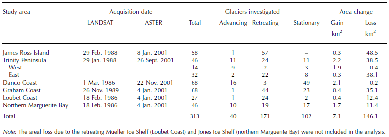
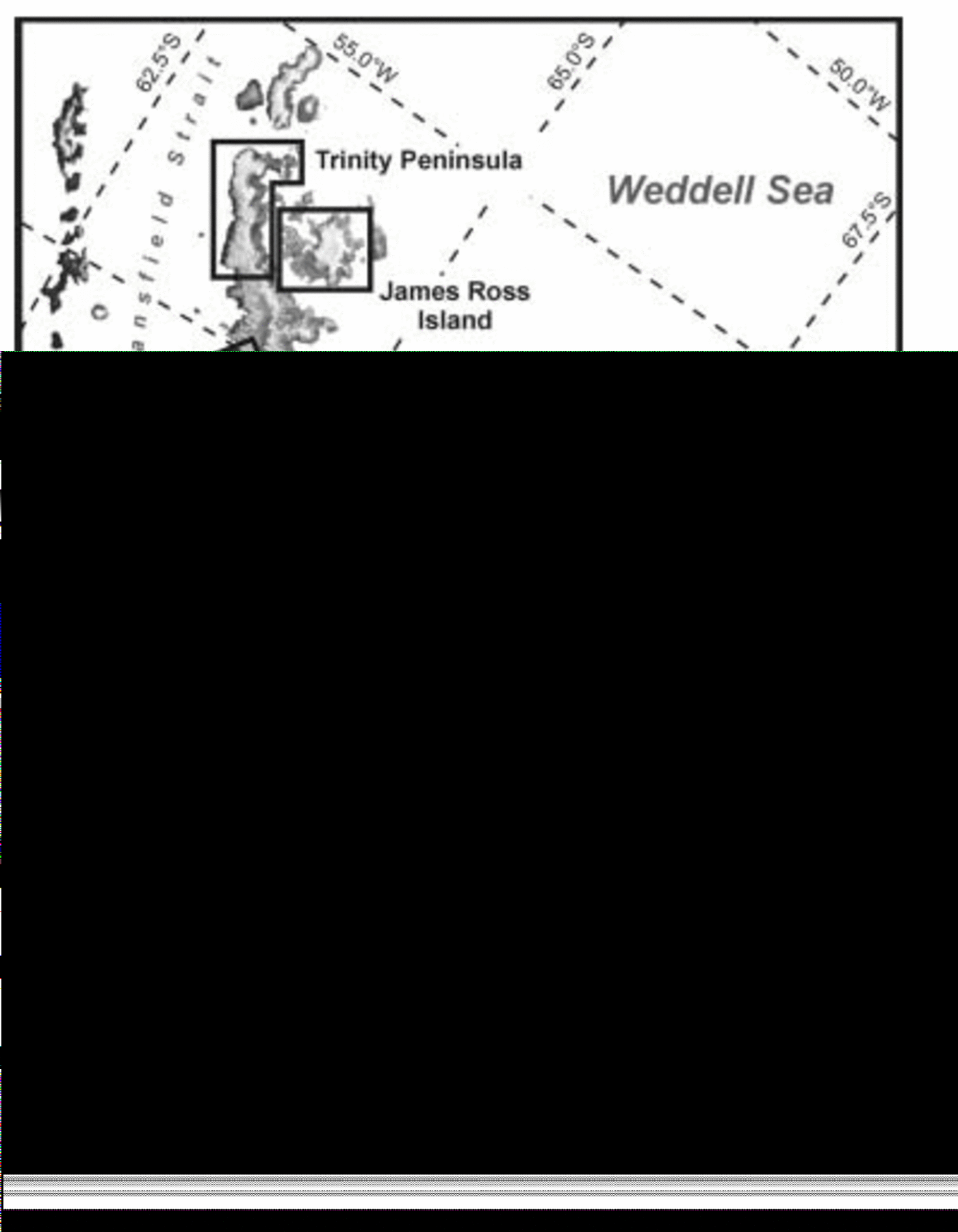
Fig. 1. The Antarctic Peninsula north of 70˚ S showing the locations of the regions specified for detailed analysis (RADARSAT ScanSAR mosaic).
Results
In order to monitor variations in glacier frontal positions and to represent the vast variety of glacial systems on the northern Antarctic Peninsula, six distinct regions of investigation (Fig. 1) were specified to correspond with the available cloud-free imagery. The results of the analysis are as follows (summarized in Table 1).
James Ross Island
The southern part of James Ross Island is characterized by a cold-based ice cap with a maximum elevation of >1600ma.s.l. and a drainage area of 1600 km2. In the northwest, a second dome-like ice mass covers an additional 403 km2. Both ice caps are drained by numerous outlet glaciers, which predominantly terminate in calving fronts at the coastline. In addition, some glaciers terminating on land are located in the northern sectors of the island, which are mainly ice-free. Of the 138 individual glaciers identified on James Ross Island, 58 were investigated during the period 1988–2001. Of these, only one showed a slight advance of the glacier front, while all the others were subject to significant retreats accounting for a net areal loss of 48.2 km2. Highest retreat rates were observed on glaciers with floating ice tongues, while the 22 glaciers investigated that terminate on land added only 2.7 km2. A partly cloud-covered ASTER scene from 29 December 2002 facilitated the extension of the analyzed period for the western parts of the island. For the 34 glaciers that were analyzable, increased retreats caused additional losses of 7.8 km2 within this 2 year period.
In comparison, Reference Skvarca, Rott and NaglerSkvarca and others (1995) reported a total loss of 22.8 km2 over a 12.4 year period (1975–88), corresponding to an average retreat rate of 1.84 km2 a–1. In the subsequent period 1988–93, the glacier area decreased by a further 10.3 km2, leading to a retreat rate of 2.08 km2 a–1.
After the disintegration of the Prince Gustav Ice Shelf in 1995, it is believed that changes in local climatic conditions had a strong impact on the island’s glaciers. Based on the presented results for the 12.8 year period (1988–2001), the recession of glaciers on James Ross Island increased to 3.79 km2 a–1. With the addition of partial results from December 2002, even further acceleration of the recession trend appears to be indicated. However, as the remnants of the Prince Gustav Ice Shelf were found to be disintegrating in 2002/03, changes in the grounding-line positions of the formerly contributing glaciers may account for some of the uncertainty in the determination of the glacier frontal positions in the affected areas. The ice masses on James Ross Island are found to have decreased by 78.8 km2 over the entire period 1975–2002, corresponding to 3.9% of the previously ice-covered area. Furthermore, it should be noted that of five investigated glaciers terminating on land between 1975 and 1988, only one displayed indications of recession. In 2002, however, 17 of the 21 monitored glaciers of this type were found to be retreating.
Trinity Peninsula
This region covers the northern tip of the Antarctic Peninsula and is characterized by several plateau glaciers. These blanket some of the highest areas of this region and drain to both sides of the peninsula via outlet glaciers, which form widespread ice piedmonts in the coastal parts. The entire glacierized area sums to 6093 km2. Of the 46 glaciers investigated, 24 account for a retreat of 38.5 km2, while 11 showed advancing ice fronts with a gain of 2.2 km2, and the other 11 were found to be in a stationary condition. Analyzing the spatial distribution of glacial behaviour, a general trend of progression was detected in the westward-draining parts. In this area, 9 of the 14 glaciers observed displayed advancing ice fronts, resulting in an increase of 1.9 km2. A further 3 glaciers indicated stationary conditions and only 2 were found to be retreating (1988–2001). In contrast, retreating glaciers prevail on the southeast coast. Of the 32 glaciers studied, 22 were found to be retreating between 1988 and 2001, accounting for an areal loss of 38.1 km2. Only 2 glaciers have shown slight advances, which are attributed to an event-specific progression of the ice front, resulting from a temporary surge of these glaciers (Reference De Angelis and SkvarcaDe Angelis and Skvarca, 2003). As a result, a retreat rate of 1.73 km2 a–1 is calculated for the northeastern parts.
Danco Coast
The glaciers and ice piedmonts terminating on the Danco Coast (64.0–64.5˚ S) are almost exclusively fed by outlet glaciers draining the southern parts of the Detroit Plateau westwards (approximate drainage area 3680 km2). Reflecting the general pattern identified on the nearby western Trinity Peninsula to the north, only minor fluctuations in the glacier frontal positions were detected during the 15.7 year investigation period (1986–2001), while 73% of the 68 glaciers analyzed showed no detectable changes, thus indicating stable conditions. With slight advances accounting for 2.1 km2 (16 glaciers) and negligible retreats accounting for 0.2 km2 (3 glaciers), these fluctuations are within the natural range of frontal variations for tidewater glaciers.
Graham Coast
The ice masses on the southern parts of the Graham Coast (66.0–66.5˚ S) are composed of outlet glaciers originating from the southern Bruce Plateau and the northern areas of the Avery Plateau (approximate drainage area 4800 km2). Of the 68 glaciers investigated, only 1 revealed an advancing front, while the majority (65%) were found to be in retreat over the reviewed 11.1 year period. With 23 glaciers stagnating, this amounts to a net areal loss of 34.7 km2. This corresponds to a retreat rate of 3.13 km2 a–1 (1989– 2001), with the highest contributions resulting from the retreat of floating or partially floating ice tongues (Fig. 2).
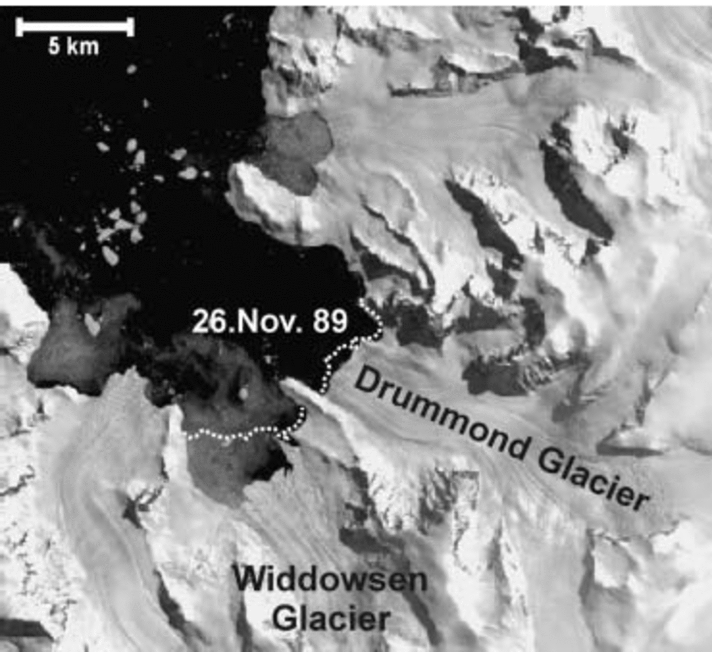
Fig. 2. Differential retreat of glacier fronts as a consequence of floating ice tongues on Widdowsen and Drummond Glaciers, Graham Coast (ASTER Level 1B, 4 January 2001). The 1989 frontal position is indicated by the dashed line.
Loubet Coast
The investigated section of the southern Loubet Coast (67.0– 67.5˚ S) comprises mountain glaciers on the Arrowsmith Peninsula and outlet glaciers, which are nourished by the ice flowing from the Avery Plateau. All these glaciers terminate in the Lallemand Fjord, and consist of an approximate drainage area of 3100 km2. Disregarding the recession of the Müller Ice Shelf, which decreased by 9.4 km2 in the observation period, the glacier retreat accounts for a 12.0 km2 net area loss (1986–2001). In spite of the low retreat rate of 0.81 km2 a–1, the general trend of recession which is observed in the adjacent Graham Coast region is confirmed, with 24 of the 27 investigated glaciers retreating.
Northern Marguerite Bay
The southernmost region surveyed includes the glaciers flowing into the northern Marguerite Bay (67.5–68.0˚ S). In the northern parts of this area, the ice originates as local mountain glaciers on the Arrowsmith Peninsula, while in the south the glaciers are partially connected to the ice masses of the central plateau areas (approximate drainage area 3600 km2). Glaciers on the adjacent islands have also been included in this analysis, but data from the decaying Jones Ice Shelf were omitted. In summary, 10 of the 46 glaciers monitored advanced during the study period, adding an area of 1.7 km2. However, 19 had retreating ice fronts and accounted for a total area loss of 11.4 km2, while the other 17 revealed stationary ice fronts during the investigation period 1986–2001 (14.9 years). The retreat rate is calculated to be 0.65 km2 a–1.
Discussion and Conclusions
The evidence presented shows a general trend of glacier front recession on the Antarctic Peninsula north of 70˚ S. These findings confirm the previously reported trend of glacier area loss from the South Shetland Islands (Reference Rau and BraunPark and others, 1998; Reference Calvet, García-Sellés and CorberaCalvet and others, 1999; Reference simões, Bremer, Aquino and FerronSimões and others, 1999; Reference Braun, Gossmann, Beyer and BölterBraun and Gossmann, 2002), James Ross Island (Reference Skvarca, Rott and NaglerSkvarca and others, 1995) and the northern Marguerite Bay (Reference Fox and CooperFox and Cooper, 1998; Reference Smith, Vaughan, Doake and JohnsonSmith and others, 1998). Furthermore, it should be noted that the absolute loss of snow- and ice-covered area is significantly higher as this study focuses only on individual glaciers, while snowpatches, ice aprons and glacier fringes are excluded from the analysis. As the analyzed glaciers displayed no indications of dynamic flow instabilities, the observed glacial variations are interpreted as direct consequences of the rapidly changing climatic conditions in the region that are affecting accumulation and ablation. However, beyond the overall tendency of retreating ice fronts, different spatial patterns of glacier variations are observed throughout the mid-1980s to 2001. In particular, an area of significant retreat is concentrated in the northeastern sectors of the peninsula (eastern coast of Trinity Peninsula and James Ross Island). Similarly, a consistent distribution of predominant glacial recession is also detectable along the southwestern coasts of the study area (Graham Coast, Loubet Coast and Marguerite Bay). This is contrasted with only slight recessions and minor advances of glacier frontal positions that were recorded in the north-western parts of the Antarctic Peninsula, which are exposed to the Bellingshausen Sea (western coast of Trinity Peninsula and Danco Coast). These observations from the northwest, which are presumed to be in the natural range of frontal fluctuations of tidewater glaciers, suggest relative dynamic stability of the glacial systems in this sector.
Although the decadal pattern of atmospheric warming is comparatively similar on both sides of the peninsula, several local factors exert a marked control on glacier response to the ongoing climatic changes. Differences in climatic regimes and variations in glacier-specific properties, such as the internal thermal structures, flow dynamics and individual catchment characteristics, determine glacial reactions to external perturbations. These differences are believed to cause the differential behaviour of the glaciers in the northwest, opposing the predominant recession detected in the northeastern and southwestern parts of the peninsula. In particular, high accumulation rates of 2.5 m a–1 (Reference Turner, Lachlan-Cope, Marshall and MorrisTurner and others, 2002) and presumably predominant polythermal temperature structures of the glaciers in the northwestern sections of the Antarctic Peninsula are assumed to counterbalance the impact of increased temperatures on the glaciers of this region. When comparing areal retreat rates, special attention must be drawn to the respective glacier types. The frontal geometry and terminus characteristics of the glacier, in particular, are important variables, as both represent essential parameters for determining the dynamic properties of the glacier. This is illustrated by the fact that in all investigated regions the highest retreat rates are obtained from glaciers with floating tongues (Fig 2). Due to their inherent instability, changes are triggered not only by climatic conditions, but also by oceanic temperature and circulation. Therefore, floating termini tend to respond rapidly to external factors, although it is difficult to distinguish a clear climate signal.
With long-term observations lacking from most parts of the investigated area, the continuation of previous glacier monitoring activities on James Ross Island (Reference Skvarca, Rott and NaglerSkvarca and others, 1995) offers the unique possibility of documenting the impact of a changing climate on a larger perspective. Hereby, a drastic acceleration of glacier recession since 1988 was determined on the island. In comparison to a retreat rate of 1.84 km2 a–1 in the period 1975–88, the annual reduction of glacierized areas doubled to 3.79 km2 a–1 in the subsequent years (1988–2001). Furthermore, contrary to the situation in 1988, the majority of the glaciers terminating on land in 2001 are retreating. In addition to the already extremely high rates of recession, multiple influencing factors need to be taken into consideration when looking at possible future scenarios. These factors include events such as the collapse of adjacent ice shelves, which affects local climatic conditions and in turn contributes to further glacial ablation.
Spatially distributed information for variations in glacier frontal positions has been presented, based on the analysis of multi-temporal satellite image data. These results add another important aspect regarding the impacts of the recent rapid climate change to the cryospheric environment of the Antarctic Peninsula, highlighting the importance of consistent glacier monitoring in this region. Innovative space-borne sensors and new data acquisition and distribution strategies have led to better coverage of the polar regions with satellite data in space and time, thus providing the required tools to accomplish the aim of establishing a functional monitoring programme and to contribute to ongoing research efforts in the field of climate change.
Acknowledgements
This study was carried out as a contribution to the multinational project ‘Global land Ice Measurements from Space’ (GLIMS) and the activities of the GLIMS Regional Center for the Antarctic Peninsula at the Department of Physical Geography, University of Freiburg. Our research was supported by the Deutsche Forschungsgemeinschaft (SA 694/2-2) and the Volkswagen Foundation within the project ‘A Glacier Baseline Inventory for the Antarctic Peninsula by Means of Remote Sensing Data and GIS Techniques’ (GLINAP). The GIA Landsat mosaic was kindly provided by J. Sievers (Bundesamt für Kartographie und Geodäsie, Germany). We are grateful for the helpful comments and proofreading by T. Myers, F. Weber and S. Hemphill.


