


Introduction
The Jell Mound at Gjellestad in Østfold, Norway, ranks as one of the largest Iron Age funerary monuments in Scandinavia. Standing in isolation on the surrounding low-lying plain, a series of archaeological surveys undertaken between 2016 and 2019 demonstrate that the Jell Mound forms part of an extensive complex that includes monumental mounds, hall buildings, traces of settlement and evidence for ostentatious burial rituals. This article focuses on the results of these new surveys and argues that Gjellestad represents a long-lived high-status cemetery and settlement, potentially connected to the elite of Southern Scandinavian Iron Age society. Its spatial and temporal organisation is paralleled by contemporaneous high-status settlements elsewhere in Southern Scandinavia, and we argue that Gjellestad represents an Iron Age ‘central place’. The concept of central places has been widely discussed in literature, but here we adhere to the definition proposed by Brink (Reference Brink1996: 236), who sees the presence of specialised buildings, exclusive artefacts, elaborate burials and place names as indicators of these nodal places in the landscape. Our results demonstrate that large-scale geophysical surveys have the potential to yield detailed information concerning settlement organisation in a multi-temporal landscape, and to improve our knowledge of past socio-political developments significantly.
Gjellestad and the Jell Mound
Gjellestad is located on the Viksletta Plain, approximately 6km west of the city of Halden (Figure 1). Viksletta comprises a 7km2 lowland that slopes gently from the surrounding wooded hills towards the coast to the south-west, where it is sheltered from the open sea by islands and islets. Afforded a favourable climate, the plain is a fertile agricultural landscape rich in archaeological sites, predominantly dating from the Bronze and Iron Ages (1800–500 BC and 500 BC–AD 1050, respectively). At present, Gjellestad is situated approximately 9–13m asl. Due to post-glacial isostatic rebound, however, sea levels would have been between 3.5 and 6.5m higher between the late third and early eleventh centuries AD (Sørensen Reference Sørensen, Selsing and Lillehammer1999), creating a sheltered bay only a few hundred metres south of the site, thus rendering it easily accessible from the sea (Figure 2).
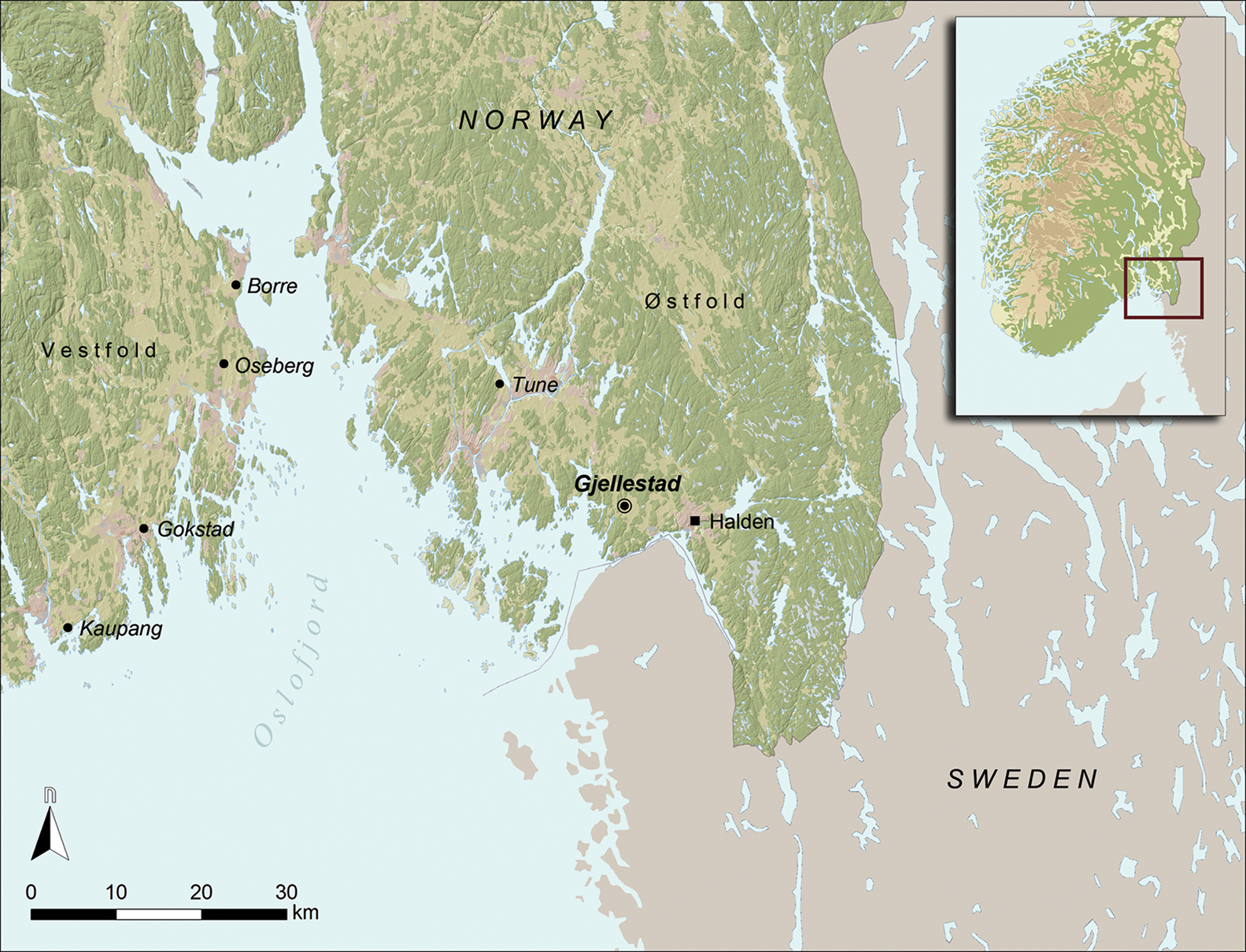
Figure 1. Location of Gjellestad close to the eastern shores of the Oslofjord, Norway, along with well-known contemporaneous sites around the Oslofjord (map source: © Kartverket/CC-BY-4.0; figure by L. Gustavsen).

Figure 2. Location map of the GPR survey area at Gjellestad, showing Iron Age sites mapped in its vicinity. To the south of the site, the change in sea level from the Iron Age to the present has been approximated (map source: © Kartverket/CC-BY-4.0; figure by L. Gustavsen).
Gjellestad is home to the Jell Mound, the second-largest burial mound in Scandinavia. Measuring 85 × 70m in plan, the mound currently stands approximately 10m above the surrounding ground surface. First described as a burial mound in a topographical treatise at the turn of the eighteenth century (Hoff Reference Hoff1794), the mound was later thought to be a glacial remnant (Nicolaysen Reference Nicolaysen1868: 72–73). The mound then lay mostly forgotten until the mid twentieth century, when a series of archaeological investigations revealed that the mound consisted of layers of cut turves covering a cremation grave. Furthermore, these investigations suggested that the mound was constructed sometime between the fifth and sixth centuries AD, and that it was either added to or broken into during the Viking Age (AD 800–1050) (Liestøl & Johansen Reference Liestøl and Johansen1970). Equally important—at least in retrospect—was information provided by the then landowner regarding three burial mounds in the field next to the Jell Mound. When levelled in the mid nineteenth century, these mounds produced grave goods including weapons and personal items, but also, intriguingly, the preserved remnants of a vessel that was “smaller than a Viking ship” (Johansen Reference Johansen1953: 461–62).
Archaeological background
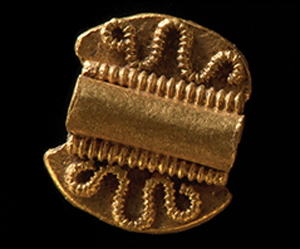
Although dominated by the Jell Mound, the Viksletta Plain hosts numerous Iron Age sites, either noted by antiquarians or inventoried by the authorities. The preserved sites consist predominantly of mound cemeteries located in the many wooded copses scattered throughout the landscape, and antiquarian sources suggest that the area was unusually rich in burial mounds, standing stones and stone circles—many of which were destroyed as a result of the intensification of farming in the nineteenth century (Nicolaysen Reference Nicolaysen1862). No longer visible on the landscape, traces of these monuments are occasionally revealed during archaeological investigations. Indeed, a 2016–2017 trial-trenching scheme carried out by Østfold County Council across the Viksletta Plain revealed several Bronze and Iron Age sites. Most notably, the scheme also unearthed settlement areas represented by postholes, hearths and cooking pits in fields to the north of Gjellestad (Figure 2); and in the field immediately to the west of the Jell Mound, ring ditches from several ploughed-out burial mounds, along with postholes and ard marks, were encountered (Berge Reference Berge2017). Previous metal-detecting surveys of this latter field had produced fragments of copper alloy brooches, rings and fittings, as well as a silver coin and fragments of precious metals, suggesting the presence of a site of elevated status. Although this assemblage has yet to be studied in detail, initial (unpublished) analyses indicate that most of the finds are of Iron Age date. The most remarkable artefact from the assemblage is a gold ‘berloque’—a type of pendant primarily dated to the Roman Iron Age (AD 1–400), and associated with high-status female burials (Solberg Reference Solberg2000: 85) (Figure 3).

Figure 3. Gold pendant: a so-called ‘berloque’ found by metal-detectorists near the Jell Mound (photograph © 2020 Kirsten Helgeland, Museum of Cultural History, University of Oslo/CC BY-SA 4.0).
Fieldwork
In early 2017, an application was made by the landowner to cut drainage ditches across the field next to the Jell Mound, triggering the need for further archaeological evaluation. The results from earlier metal-detecting and trial-trenching campaigns (Berge Reference Berge2017) suggested the potential for encountering substantial but fragile archaeological features, and a minimally invasive approach was chosen in order to mitigate the physical impact on the underlying archaeology. This was achieved using a motorised high-resolution ground-penetrating radar (GPR) system, with surveys carried out in April and August 2018, and in January 2019. To verify the results of the geophysical surveys and to obtain datable material, trial trenches were excavated in September 2019, with targeted excavations of selected structures undertaken to provide information on preservation. The results of these excavations are being processed and will be reported in due course.
GPR survey results
The heterogeneous character of the local subsoil has resulted in geophysical datasets characterised by highly variable and contrasting responses. Furthermore, it is clear from the datasets that modern ploughing has damaged the underlying archaeology. Despite this, the GPR surveys have revealed anomalies in the form of postholes, wall-ditches and hearths belonging to at least four house structures, as well as numerous ring ditches associated with burial mounds, one of which encircles a large, elliptical anomaly that we interpret as a ship grave (Figure 4).

Figure 4. Combined interpretation map of the Gjellestad site based on the geophysical survey (map source: © Kartverket/CC-BY-4.0; figure by L. Gustavsen).
The mound cemetery
At least nine smaller, circular mounds (M1–7 and M9–10) and one oval mound (M8) have been observed in the geophysical dataset (Figure 5). The circular mounds are represented by annular ditches forming circular features, each between 7m and 11m in diameter, while the oval mound (M8) is represented by two parallel, slightly curved ditches forming a structure approximately 15m in length and 6m in width. The oval mound is possibly a longmound, a type of burial mound often found as part of Iron Age mound cemeteries in Norway, where they are associated with female burials (Tsigaridas Reference Tsigaridas1998: 2).

Figure 5. Left) interpretation map of the mound cemetery based on the full depth-range of the GPR dataset; right) corresponding depth slices from the depth-range 0.3–0.8m below the ground's surface (map source: © Kartverket/CC-BY-4.0; figure by L. Gustavsen).
The ditches associated with these mounds are quite well defined in the geophysical data against the mixed subsoil matrix, and it is possible to discern potential stratigraphic relationships between them. Mounds M3 and M10, for instance, appear to be truncated by later features, whereas mound M9 appears to overlie an earlier mound. Internal features that potentially represent central graves can be observed within several of the mounds, but their ambiguous characteristics do not allow for certainty.
Three of the identified burial mounds are distinct from the smaller circular mounds due to their large size. Two of these are located directly south of the smaller mounds, and are identified as large, circular areas consisting of homogeneous material with highly reflective properties. The central part of the westernmost mound (M11) is approximately 30m in diameter and is encircled by a highly fragmented and poorly defined ditch. The entire structure has a somewhat uneven shape with an assumed maximum diameter of 39m. While some internal features can be discerned, these cannot currently be interpreted, although the outer edges of a possible stone cairn were encountered during trial-trenching in 2017. To the east of mound M11, mound M12 measures approximately 28m in diameter, including a ditch that is only preserved towards the north-west and west. Stratigraphically, it appears that M11 truncates parts of the smaller mound M3 to the north, whereas mound M12 seems to be overlain by circular mound M9 to its south.
The ship mound (M13) is located to the immediate south of mounds M11 and M12 (Figure 5). Several construction elements can be observed in the GPR data. The mound-base element comprises a large circular area with relatively highly reflective properties, and is clearly defined against the surrounding soil matrix. This measures up to 15m in diameter and is encircled by a 10m-wide area with poorly defined edges and variable reflective properties. Within the mound base is the central feature: an elliptical anomaly approximately 19m in length and 5m wide, and 0.3–1.4m below the ground's surface. The elliptical anomaly, which we interpret as the remains of a ship burial, appears as homogeneous with attenuating properties and is clearly defined against the soil matrix of the mound base. Near its base, a narrow, linear anomaly with reflective properties can be seen. This anomaly, which measures 9m long and up to 0.5m wide, could represent the remains of the ship's keel. Overlying and extending beyond the western edge of the ship-shaped anomaly is a rectangular anomaly with slightly absorbing properties. It measures approximately 4.6m in length and 2.6m in width, and can be observed to a depth of 0.8m below the ground's surface. Although there is some uncertainty concerning what this anomaly represents, for the moment we interpret it as a later intrusion into the mound.
Settlement structures (H1–H4 and fence)
A total of four house constructions can be discerned in the GPR data. Of these, houses H1–H3 form a group to the immediate west of the mound cemetery (Figure 6), while house H4 is located some 80m to the south of the main structures. All of the houses are oriented north to south, and are represented by roof-bearing postholes. Only house H4 has traces of a wall ditch.

Figure 6. Left) interpretation map of structures H1–3; right) aggregated GPR amplitude slices (inverted) of the same area, from 0.5–1m below the ground's surface (map source: © Kartverket/CC-BY-4.0; figure by L. Gustavsen).
House H1 comprises ten well-defined postholes paired in trestles within a three-aisled structure. The house features two pairs of postholes at the southernmost end, which represent opposing entrances on each side of the house. Its roof-bearing postholes measure up to 0.7m in diameter, with estimated depths of 0.5m. To the north of the entrances is an open room with an approximately 50m2 floor plan that includes a possible hearth. Other features that might potentially be expected, such as a surrounding wall-ditch or wall-posts, or additional roof-bearing postholes, are absent. Hence, while the width of the house can be confidently established at 7m, the full length of the house can only be estimated at 19–21m.
Immediately to the south of H1, house(s) H2 consists of six or possibly eight postholes in trestle pairs. The postholes are up to 0.7m deep and up to 1.3m in diameter. Due to modern disturbance, our understanding of the northern trestle pair remains tentative and permits two interpretations of the building. If all eight postholes belong to the same house, the overall length of the structure would be 28m, with an estimated width of 6.5m. The length between the southern and northern trestles is approximately 11.5m, creating a central room with a floor plan of around 80m2. This scenario, however, requires us to accept the abnormal longitudinal distance between trestles, and assumes that existence of undetected postholes exist between them. An alternative, and perhaps more probable, interpretation is that the postholes instead represent two separate four-post structures.
Immediately to the east of H2 is house H3, which comprises 12 clearly defined postholes paired in trestles. These form a 38m-long three-aisled house, with an estimated width of around 7m. The roof-bearing postholes are up to 0.7m deep and up to 1m in diameter. The lateral distance between the postholes increases from 2m at each gable end to 3m at its centre, suggesting slightly convex walls. While the spacing between the trestle pairs is approximately 5m between the three southernmost, and two northernmost trestles, the distance between the central trestles is around 8m. This gives the house an asymmetrical layout with two large rooms—each measuring around 60m2 in plan—placed near its centre. A row of around 20 small post- or stakeholes extends from the south-eastern corner of the house, forming a fence that runs south-eastwards across the field. The exact spatial and temporal relationship between the fence and the houses is unknown, and it is unclear in the GPR data whether it extends farther to the north and south.
House H4 is located in the south-western part of the survey area, seemingly separated from the cemetery and buildings to the north. It comprises several features, of which at least eight are identified as roof-bearing postholes. The postholes are bounded by a narrow, linear ditch with rounded corners. Observable only to the east of the house postholes, the ditch appears to have been cut by modern drainage ditches at each extremity. Nevertheless, it is possible to estimate that the building measured 27m in length and up to 10m in width.
Discussion
Determination of the dates of the structures identified in the GPR survey is complicated by the longevity of the general typological forms and by the uniqueness of some of the variations found at Gjellestad. Similarly, the determination of stratigraphic interrelationships based solely on geophysical data is problematic. Gjerpe (Reference Gjerpe, Iversen and Petterson2016) has shown that Iron Age houses in eastern Norway follow regional and local building traditions, rather than a common, overarching Scandinavian tradition. The extensive variety in the corpus of buildings and the lack of an established typology therefore complicate any attempt to date the houses identified at Gjellestad on the basis of the GPR results alone. This is further exacerbated by the lack of any discernible stratigraphic relationships between the houses and nearby structures. Thus, pending further investigations, it is currently only possible to provide tentative interpretations related to temporal developments, the function of specific structures and therefore the overall significance of the site. We nevertheless attempt to explore further the potential significance of our initial interpretations of the datasets with a discussion of the nature and character of the site and a suggested chronological framework. Furthermore, we discuss what type of site Gjellestad represents and explore its significance in relation to its wider cultural and historical contexts.
Our discussion starts with the smaller burial mounds observed in the northernmost part of the field (M1–M9). In Norway, burial in earthen mounds is primarily an Iron Age phenomenon (Gansum Reference Gansum2004: 74). As this rite is ubiquitous throughout the period, it is not possible to establish an exact date range based on typology alone. In this case, however, a few assumptions can be made. The observed stratigraphic relationships indicate that the smaller mounds are earlier than the larger mounds, and may therefore represent a first phase of activity at Gjellestad. Their similarity in size to the mounds surviving in nearby woodland may suggest that they were once part of a larger cemetery—much like that surviving a few hundred metres to the north of Gjellestad. Cemeteries such as these, which are common in the region, can consist of anything from a few to several hundred mounds, and presumably represent the burial places of local families or farmstead units (Solberg Reference Solberg2000: 78). Some of these cemeteries were in continuous use throughout the Iron Age, and, although it is not possible to date securely the small mounds at Gjellestad based on GPR data alone, it should be noted that a similar development has been suggested for the high-status mound cemetery at Borre in Vestfold (Myhre Reference Myhre2015: 87–88).
It is perhaps within this initial phase that the two smaller—and arguably more mundane—houses (H1 and H4) at Gjellestad should be placed, although the lack of a defined typology and stratigraphic relationships does not preclude a later date. As house H1 features at least two opposing entrances in its southern part, the building falls within the definition of a ‘mid Scandinavian’ building type, in which the entrances are located near the gable ends. Conversely, house H4 appears to have its entrances located near the centre, thereby falling within the ‘Southern Scandinavian’ building type. Both building types are well known from the corpus of excavated examples in Østfold, where they predominantly dated to the Early Iron Age (Gjerpe Reference Gjerpe, Iversen and Petterson2016: 210). We have therefore chosen to interpret H4 as a common farmhouse. Its layout suggests that it is probably an early structure at the Gjellestad complex.
The initial phase of activity seems to have been followed by the construction of two large mounds, M11 and M12—a chronological development supported by the possible truncation of the small mound M3 by mound M11. Large burial mounds such as these typically first appeared in the Viken area in the fifth and sixth centuries AD. Representative examples include Rakni's Mound in Romerike, Halvdan's Mound in Ringerike, and Grönehög, situated immediately across the Swedish border to the south of Gjellestad (Lindqvist Reference Lindqvist1929; Skre Reference Skre1997; Rolfsen & Larsen Reference Rolfsen, Larsen, Larsen and Rolfsen2004). Although these examples have produced little in terms of traditional, high-status grave goods, considerable communal resources must have been allocated to their construction. This expenditure of resources has linked these mounds inextricably to the idea that they are markers of emerging dynastic elites, with organisational capabilities, wealth and a desire to make their presence in the landscape felt. In this respect, it is notable that the earliest date for the Jell Mound falls within the fifth to sixth centuries AD, and it is tempting to consider mounds M11 and M12 as part of this development. Some caution in this interpretation should, however, be exercised. The construction of large burial mounds continued into the seventh to the ninth centuries, and also during the Viking period (Myhre Reference Myhre and Carver1992). As such, the large mounds in the field at Gjellestad could date to anytime between the fifth and the tenth centuries AD.
A developmental feature within longhouses from the Roman Iron Age onwards is the hall: an area dedicated to the display and reinforcement of status through feasting and religious and political assemblies (Eriksen Reference Eriksen2019: 66). In the earliest examples, this is identified as a larger room within the building, created by increasing the distance between some of its trestles. Later, the hall is transformed into a separate building, set apart from the ordinary dwelling houses of the settlement. Several criteria have been proposed for the exact definition of such halls. These predominantly concern the size of the building and its constituent parts, its layout and construction method, its position in relation to nearby settlement and mortuary structures, its setting in the landscape and the presence of ‘special’ finds indicative of its high status (Herschend Reference Herschend1993; Carstens Reference Carstens, Eriksen, Pedersen, Rundberget, Axelsen and Berg2015). It is not possible to test all of these criteria against the GPR data for the buildings at Gjellestad, as some require excavation and soil analyses. There can be no doubt, however, that house H3 is a substantial building, at least in regional terms. It measures over 38m in length and, although somewhat shorter than hall buildings identified in other parts of Southern Scandinavia, it is comparable in size to the recently discovered hall buildings at the high-status cemetery at Borre in Vestfold (Tonning et al. Reference Tonning2020). Furthermore, as the average length of three-aisled buildings in Østfold is approximately 20m (Gjerpe Reference Gjerpe, Iversen and Petterson2016: 211), H3 must be considered a building of unusual size. Its large postholes also suggest that it was built using solid roof-bearing posts capable of supporting a building of some height. This, and its location overlooking the slopes of the Viksletta Plain, would have resulted in an easily recognisable marker in the landscape, one clearly visible from the seaward approach, if not from the outer sea lanes.
The size and character of house H3 indicate a function beyond that of an ordinary habitation, and we hypothesise that it represents a hall building. Its construction method, which includes convex walls, indicates a Late Nordic Iron Age date, although it should be noted that this building trait continued into the Viking Age (Eriksen Reference Eriksen2019: 47). The fence stretching southwards from H3, identified in the GPR data, may form part of the same phase. While its temporal relationship with the surrounding houses and the mounds is unclear, it is notable that the fence appears to form a boundary across the site, with most of the houses placed to its west and the mounds to its east. Whether it represented a physical boundary, or a divide between the realms of the living and the dead, however, remains open to speculation.
There is some ambiguity as to whether house H2 represents a single post-built structure or two smaller four-poster buildings. The parallel orientation of the postholes with those in H3 suggests that it is all one building, and that some degree of contemporaneity existed between H2 and H3. Its construction method as observed in the GPR data is, however, untenable. The abnormal trestle distances instead suggest that the building was of a type that is only partially detectable in the geophysical record, where posts resting on sillstones (that are no longer present) may have existed between the observed trestles. The argument for H2 being a single building is further supported by both the size of the postholes, which, like those in H3, are substantial, and by the presence of a possible hearth placed centrally between the trestle pairs. Given its unusual form, it is unlikely to represent a building intended for habitation. Furthermore, its juxtaposition with monumental burial mounds and another possible hall building suggests a more specialised function. In this respect, it should be noted that unusual buildings with few, yet substantial, postholes have been interpreted as hall buildings at other Iron Age central places. These include Gudme in Denmark (Østergaard Reference Østergaard1994) and Helgö in Sweden (Herschend Reference Herschend1995), where they are interpreted as separate hall buildings, and at Uppåkra in Sweden, where such a structure has been interpreted as a building for religious purposes (Larsson Reference Larsson2007). These buildings are associated with the need for an established aristocracy to convey social, judicial and perhaps religious authority and status, and the presence of such a building at Gjellestad would further underpin the site's status as a central place.
As a ship burial, mound M13 should be easier to place within our chronological framework. The origins of the Northern European boat-burial tradition can be traced to the areas around Scania and Bornholm in the first century AD (Bill Reference Bill and Skre2019: 374), and it disappeared with the gradual introduction of Christianity to the region in the tenth and eleventh centuries. The tradition appears to have been adopted by elite communities on the west coast of Norway sometime in the late eighth century AD, potentially through contact with similar dynasties in England; and a few centuries later, the tradition made its appearance in eastern Norway (Bonde & Stylegar Reference Bonde and Stylegar2016). Several hundred graves featuring boat burials are known in Northern Europe, and a number have been encountered in the Østfold region (Müller-Wille Reference Müller-Wille1974; Stylegar & Norseng Reference Stylegar, Norseng, Pedersen, Stylegar and Norseng2003). Burials including ocean going ships—vessels exceeding 12m in length (Paasche Reference Paasche2010: 40)—must, however, be considered a rarity. Within the Oslofjord region, the well-known ship burials at Oseberg, Gokstad, Tune and Borre all date to the ninth and early tenth centuries, and it is perhaps within this date range that the Gjellestad burial should be placed. The anomaly representing the trench excavated to accommodate the vessel appears as a 19 × 5m-wide boat-shaped feature in the upper parts of the dataset (Figure 7). If this anomaly truly represents the lower portion of the vessel, we can probably add another 1.5m to both the stem and stern, thereby suggesting an original length of approximately 22m. This would place it on a par with the Oseberg and Gokstad ships, while it is slightly longer than the Tune ship. With a length-breadth ratio of 4.4:1, it probably represents a ship propelled by sail rather than oars, although this relies on an accurate extrapolation of the geophysical anomaly's true original form. If we are correct, this interpretation would place the Gjellestad burial neatly amongst the group of Viking ships excavated along the Oslofjord (Bill Reference Bill and Klæsøe2010: 23–24), and it should provisionally be regarded as part of this tradition.

Figure 7. Left) aggregated GPR amplitude map of the ship burial from a depth-range of 0.3–0.5m below the ground's surface; right) amplitude map of the ship burial from a depth-range of 0.9–1.1m below the ground's surface (figure by L. Gustavsen).
The rectangular (putative) robber trench observed across the central-western part of the ship burial has a neat appearance in the GPR dataset, with straight, well-defined edges. Similar intrusions have been observed in other ship burials around the Oslofjord, and all appear to have been made around the mid tenth century, perhaps as part of a coordinated effort (Bill & Daly Reference Bill and Daly2012). Due to their neat appearance, it has been suggested that these intrusions were part of public displays rather than covert acts carried out for material gain. Such public displays could represent yet another political statement, this time consolidating regional power and legitimising ownership to the land by desecrating, rather than erecting, monuments (Bill & Daly Reference Bill and Daly2012).
The cemetery at Gjellestad appears to have been long-lived, and the size of its mounds, their juxtaposition with potentially high-status buildings and the presence of grandiose burial rites all point to Gjellestad being a site of some importance in the Late Iron Age. In this tumultuous time, land ownership was contested and control frequently fluctuated between dynastic families. It is against this background that the emergence of Gjellestad must be considered—as a clear statement by a community reinforcing its ties to the landscape in a bid to legitimise its social and political standing. As such, it is tempting to class Gjellestad as an Iron Age central place akin to those attested at Lejre, Gudme and Tissø in Denmark, Gamla Uppsala, Järrestad and Uppåkra in Sweden, and Borre, Åker and Kaupang in Norway (Christensen Reference Christensen1991; Hagen Reference Hagen, Mikkelsen and Larsen1992; Myhre Reference Myhre and Carver1992; Hårdh Reference Hårdh2000; Söderberg Reference Söderberg, Larsson and Hårdh2003; Skre Reference Skre2007; Jørgensen Reference Jørgensen, Ludowici, Jöns, Kleingärtner, Scheschkewitz and Hardt2010; Ljungkvist & Frölund Reference Ljungkvist and Frölund2015). Undoubtedly associated with the upper echelons of society, these sites all exhibit traits suggestive of shared ideology and practice, strong cultural connections and a homogeneity in the expression of power. They typically take the form of hall buildings, imported objects, weapons or tools, and exceptional mortuary monuments, such as large mounds and boat/ship burials. Furthermore, intangible evidence in the form of distinctive groups of place names has been taken as indicators of such political power (Brink Reference Brink1996: 236).
With its putative hall building and cult houses, and monumental mounds featuring extravagant grave fittings, Gjellestad fits—at least partially—into this group of elite settlements. Nevertheless, there is compelling evidence from the immediate environs that must be pursued to strengthen this hypothesis. Preliminary results from metal-detecting in the area, for example, have produced some tantalising distribution patterns. Although the finds at Gjellestad comprise predominantly fragments of personal adornments, the fields to the south and close to the Iron Age shoreline have produced objects associated with trade and production, including lead scale-weights, spinning whorls and Frankish coinage (Figure 8). The finds at Gjellestad undoubtedly relate to the mound cemetery and the settlement traces attested through geophysical surveys and trial-trenching. We consider the finds from near the former shoreline, however, as indicators of a local trade-and-production site, perhaps similar to those excavated at Kaupang and Heimdalsjordet, both in Vestfold (Skre Reference Skre2007; Bill & Rødsrud Reference Bill, Rødsrud, Glørstad and Loftsgarden2017).

Figure 8. The distribution of metal-detecting finds based on data from the Norwegian sites and monuments database (map source: © Kartverket/CC-BY-4.0; Askeladden, Norwegian Directorate for Cultural Heritage 2020; figure by L. Gustavsen).
Conclusions
The combined use of metal-detecting, trial-trenching and geophysical methods has produced results suggestive of a long-lived, high-status site at Gjellestad. We suggest that the site has its origins in an ordinary mound cemetery, which was later transformed into a high-status cemetery represented by monumental burial mounds, hall buildings and a ship burial. Indicative of the emergence of a central place in a time when control of the land was in flux, Gjellestad's relevance as a political arena was retained and reinforced with the addition of a ship burial—the ultimate expression of status, wealth and connection in Iron Age Scandinavia. The later probable break-in would serve to support this interpretation. Rather than a careless, clandestine excavation, we believe that it represents the physical manifestation of a political act, undertaken to affirm or reaffirm dynastic influence and power.
The investigations so far undertaken reveal much about the site, and we propose that our suggested hypotheses be used as a framework for future studies of Gjellestad and of similar sites across Scandinavia. Such research will undoubtedly resolve some of the issues outlined here, while further contributing to our understanding of the character and development of social, political, administrative and religious aspects of Southern Scandinavia in the Nordic Iron Age.
Acknowledgements
The authors thank the two anonymous reviewers for their useful comments and suggestions. Furthermore, we would like to thank the landowner, Olav Jellestad, for his hospitality and support during the fieldwork. We also extend our gratitude to Rebecca J.S. Cannell at the University of Oslo for proofreading the article. The Norwegian Institute for Cultural Heritage Research is a partner in the Ludwig Boltzmann Institute for Archaeological Prospection and Virtual Archaeology (LBI ArchPro) research institute, without which the presented research would not have been possible. The LBI ArchPro is made up of the following institutes: The Province of Lower Austria (NoeL), the Roman-Germanic Central Museum in Mainz, LWL—Archäologie für Westfalen, ArcTron 3D, the Vienna University of Technology with the Institute for Computer Graphics and Algorithms and the Institute for Photogrammetry and Remote Sensing, the University of Vienna with the Vienna Institute for Archaeological Science and the Institute of Prehistoric and Historical Archaeology, Vestfold Fylkeskommune, Airborne Technologies, 7reasons Medien GmbH and the Department of Applied Geophysics at the Central Institute for Meteorology and Geodynamics.
Funding statement
This research received no specific grant from any funding agency, commercial or not-for-profit sectors.


 Open access