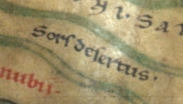
Name: Sorsdesertvs
Feature type: region
Segment grid: 7A5
On land in the uppermost part of the map, between Tomis (7A4) and Trapezvnte (9A2), numerous names are marked in black in the style of placenames, none linked to the route network, and several more or less certainly not placenames. For the difficulty of distinguishing between people-, region- and place-names, see further Chapter 3 sect. 3 (f).
It seems most likely that "Sorsdesertvs" should signify a physical feature, or the name of a region. For "sors" used of (assigned) land, see s.v. in index to B. Campbell, The Writings of the Roman Land Surveyors (London, 2000).
I read the name as one word, not two, because no stop appears within it, and the "d" is not capitalized.
References
- ? = BAtlas Eremia Geton 23 C3
- ItMiller 617
- Podossinov2002 339