Name: Fl. Chvlcvl
Feature type: river
Segment grid: 4C1
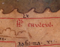
Since the river course is missing and the name is clear, no number is assigned.
The scanned image leaves the distinct impression that the copyist began to draw the river course to the sea from the righthand end of mountain range #32 below the name. He then realized that he had erred in starting below the mountain range, rather than above it (otherwise the river would need to flow over the mountains). So he erased what he had drawn; hence the two breaks in the mountain range, and the line of white extending between Fl. and Chvlcvl. But he never repaired the two breaks, nor made a further attempt to mark the river course.