Hostname: page-component-78c5997874-xbtfd Total loading time: 0 Render date: 2024-10-31T13:08:36.719Z Has data issue: false hasContentIssue false

Ideal distribution models and the tempo of agricultural development in a windward valley of Hawaiʻi

Published online by Cambridge University Press:  23 August 2023

Seth Quintus*
Affiliation:
Department of Anthropology, University of Hawaiʻi at Mānoa, Hawaiʻi
Timothy M. Rieth
Affiliation:
International Archaeological Research Institute, Inc., Honolulu, Hawai‘i
Thomas Dye
Affiliation:
Department of Anthropology, University of Hawaiʻi at Mānoa, Hawaiʻi
Alexander E. Morrison
Affiliation:
Department of Anthropology, University of Hawaiʻi at Mānoa, Hawaiʻi
Christopher W. Filimoehala
Affiliation:
International Archaeological Research Institute, Inc., Honolulu, Hawai‘i
Darby Filimoehala
Affiliation:
International Archaeological Research Institute, Inc., Honolulu, Hawai‘i
Jon Tulchin
Affiliation:
Wahi Kūpuna Program, Kamehameha Schools, Honolulu, Hawai‘i
Trever Duarte
Affiliation:
Wahi Kūpuna Program, Kamehameha Schools, Honolulu, Hawai‘i
*
*Author for correspondence ✉ squintus@hawaii.edu
Rights & Permissions [Opens in a new window]

Abstract

Across the Pacific, agricultural systems have used two main complementary cultivation regimes: irrigated farming of wet environments and rain-fed cropping of drylands. These strategies have different productive potential and labour needs, which has structured their temporal and spatial distributions. Although these approaches have been studied a great deal at a general level, there has been less work on the local use and significance of these strategies. Here, the authors evaluate ideal distribution models of agricultural activities in the Punalu‘u valley on O‘ahu, Hawai‘i, to assess how habitat suitability changed as a result of infrastructural investment and dynamic environmental, social and demographic change. The results are of relevance for contemporary initiatives to revive Indigenous agricultural systems in Hawai‘i and beyond.

Type
Research Article
Copyright
Copyright © The Author(s), 2023. Published by Cambridge University Press on behalf of Antiquity Publications Ltd.

Introduction

Traditional agricultural systems incorporate multiple crops and cultivation practices adapted to diverse environments. These choices and routines, and their development over time, are intertwined as each one shapes the wider socio-ecological context within which others are practised. The Indigenous agricultural systems of many Pacific Islands, with a primary distinction between wet environments where irrigation is used and dry environments dependent on rainfall, typify this relationship (Barrau Reference Barrau1965; Kirch Reference Kirch1994). This is the case in the Hawaiian archipelago, a region first settled approximately 1000 years ago (Handy et al. Reference Handy, Handy and Pukui1972; Athens et al. Reference Athens, Rieth and Dye2014). Here, distinct variations of this basic agricultural dichotomy can be observed at three spatial scales. At the archipelago scale, irrigated pondfield cultivation (lo‘i) was widely established in the northern islands, where erosion has carved well-watered valleys; in contrast, extensive rain-fed dryland systems were prevalent in the geologically younger southern islands where soils retained more rock-derived nutrients (Ladefoged et al. Reference Ladefoged, Kirch, Gon, Chadwick, Hartshorn and Vitousek2009). At the scale of individual islands, archaeological evidence for irrigation techniques is predominantly found in windward valleys where there is adequate rainfall and permanent streams and rivers (Ladefoged et al. Reference Ladefoged, Kirch, Gon, Chadwick, Hartshorn and Vitousek2009). In contrast, evidence for rain-fed systems is typically found on leeward slopes in locations where sufficient rainfall, temperature and soil nutrients create ‘sweet-spots’ for cultivation (Vitousek et al. Reference Vitousek, Ladefoged, Kirch, Hartshorn, Graves, Hotchkiss, Tuljapurkar and Chadwick2004). These take the form of either expansive, formal field systems extending across moderate to gently sloping terrain (e.g. Ladefoged & Graves Reference Ladefoged and Graves2008) or spatially constrained, less structured complexes on colluvial slopes (e.g. Rieth & Tomonari-Tuggle Reference Rieth and Tomonari-Tuggle2013). Finally, at the scale of individual valleys, archaeological evidence for wetland techniques is found on alluvial plains and terraces, adjacent to streams or located in marshland areas, while dryland techniques are practised on the colluvial slopes formed through the erosion of valley cliffs (Kirch Reference Kirch1977; Kurashima & Kirch Reference Kurashima and Kirch2011).

The predominant crops that were cultivated across the cultural sequence reflect the environmental conditions. Taro (Colocasia esculenta, kalo) was most productively grown in irrigated fields organised into a system of raised beds or bounded pondfields, though it was also grown in rain-fed settings with sufficient precipitation (Handy et al. Reference Handy, Handy and Pukui1972). In contrast, sweet potato (Ipomoea batatas, ‘uala) was the primary crop grown in rain-fed settings. Originally domesticated in South America and introduced to Hawaiʻi around the fourteenth century AD (Ladefoged et al. Reference Ladefoged, Graves and Coil2005), the crop filled an environmental niche where taro could not be grown or was less productive. Mixed cropping, including arboriculture, took place across colluvial slopes in windward valleys and the crop roster in each location was likely targeted to local environmental characteristics (Kirch Reference Kirch1977).

In the tenth and eleventh centuries AD, the initial Polynesian inhabitants of Hawaiʻi settled in the well-watered, east-facing windward valleys of several islands, constructing irrigation infrastructure within the first 200 years of settlement (McElroy Reference McElroy2007; McCoy et al. Reference McCoy, Browne Ribeiro, Graves, Chadwick and Vitousek2013; Athens et al. Reference Athens, Rieth and Dye2014). Robust dating for these irrigated systems is, however, limited (see Dye Reference Dye2016). Rain-fed, dryland cultivation infrastructure was initially constructed in the fifteenth century (Allen Reference Allen2004; Ladefoged & Graves Reference Ladefoged and Graves2008; Quintus & Lincoln Reference Quintus and Lincoln2020), as settlement expanded into leeward areas, with further expansion in the seventeenth century and later (Dye Reference Dye2014). The development of dryland infrastructure in colluvial-slope environments seems to follow a similar chronology to general leeward environments (Morrison et al. Reference Morrison2022), though research in colluvial environments is currently limited. Rapid depopulation after European contact at the end of the eighteenth century was followed by the abandonment of most agricultural infrastructure, particularly in areas of dryland cultivation.

Evidence for agricultural systems has played a prominent role in the construction of archaeological narratives about the archipelago (e.g. Kirch Reference Kirch1994, Reference Kirch2010; Hommon Reference Hommon2013). The development of irrigated agriculture has been frequently linked to population growth, leading to settlement expansion into more marginal leeward environments. This, in turn, gave rise to productive variability in divergent environments, setting in motion cycles of intensification and the production of agricultural surpluses. The varying productive capacity of different agricultural practices has been argued to be a cause of warfare, the consolidation of political units, and the growth of ‘archaic states’ by the eighteenth century (Kirch Reference Kirch2010; Hommon Reference Hommon2013, but see Bayman et al. Reference Bayman, Dye and Rieth2021).

While we have a broad understanding of the temporal development of agricultural techniques at the archipelago scale, robust local-scale chronologies, notably within individual valleys, are limited, for both irrigated and colluvial-slope practices. As these techniques provided the bulk of food production in the northern islands of the archipelago, better data on their development is key to linking agriculture to other themes of Hawaiian history. Furthermore, we expect the incorporation of different agricultural activities to have varied within and between individual valleys, and better understanding of temporal variation of these techniques at the local scale may provide insights into demographic expansion and the growth of social inequality across the islands. Localised chronologies can help us understand not only the date of the initial construction of infrastructure, but also the ongoing tempo of agricultural works across divergent environments, which is largely unknown over the longer cultural sequence. Such gaps in our knowledge limit understanding of changing agricultural habitat suitability and the drivers of those changes. Finally, understanding the development of these systems and their relationships with landscape suitability and labour is an essential prerequisite to reinstating these cropping systems to support contemporary food production.

To this end, this article brings together and compares a suite of radiocarbon dates from two agroecosystems in the windward valley of Punaluʻu on the island of Oʻahu. Using Bayesian models, we highlight temporal relationships between these two systems, which we visualise with tempo plots; we also use ideal distribution models to conceptualise the socio-ecological embeddedness of different production techniques. Through this research, we are better positioned to understand the drivers of changing agricultural habitat suitability in Hawaiʻi, the tempos of agricultural development in divergent environments and the linkages between environment, agriculture, demography and political organisation.

Ideal distributions and Hawaiian agricultural practices

Ideal distribution models, or IDMs, consider the relationship between population density, habitat characteristics and social controls to understand how organisms distribute themselves across space (Fretwell & Lucas Reference Fretwell and Lucas1969). Drawing from a formal body of theory, these models provide testable hypotheses of human subsistence and settlement behaviour in response to environmental and social factors (Prufer et al. Reference Prufer, Thompson, Meredith, Culleton, Jordan, Ebert, Winterhalder and Kennett2017). The models predict how human settlement may be conditioned by characteristics of habitat suitability, or the potential for a habitat to have a positive impact on the success of an individual (Weitzel & Codding Reference Weitzel and Codding2020: 2). While IDMs assume that humans will maximise suitability of any particular habitat, suitability is not static (Bliege Bird et al. Reference Bliege Bird, McGuire, Bird, Price, Zeanah and Nimmo2020); rather, it is dependent on a range of social and environmental factors that influence the costs and benefits of using particular habitats over time.

We explore these concepts of dynamic habitat suitability around three iterations of IDMs. First, ideal free distribution models assume that when individuals enter a new environment, if their choices are unconstrained, they will use the areas that are most suitable. Suitability is determined by the density and distribution of useful resources given a particular subsistence strategy. In an ideal free distribution, there is negative density dependence, and habitat suitability declines with increasing human population density and the depletion of resources (Fretwell & Lucas Reference Fretwell and Lucas1969). This, in turn, leads to the use of less-suitable habitats. This leads us to the second model iteration: an ideal free distribution with an Allee effect, which is positive density dependent in the sense that higher population densities make some habitats more appealing (Allee Reference Allee1931). This iteration recognises that, in some environments, a dense population may generate opportunities for habitat enhancement by way of agricultural infrastructure and other investments (e.g. anthropogenic soils). Alternatively, larger populations may allow for opportunities to employ more labour-intensive strategies or intensify cropping cycles (Kirch Reference Kirch1994). There is an optimal group size, however, after which increases in population density would result in reduced suitability (Weitzel & Codding Reference Weitzel and Codding2020). The third model iteration, the ideal despotic distribution, predicts human use of habitats under constrained conditions. These constraints might be physical, such as when infrastructure reduces the potential for subsequent investment, or social, for example, when there are claims of prior possession that limit available resources. In these situations of negative despotism, marginal areas might be used before population density in suitable areas reaches a sustainable maximum. This is because increased territoriality reduces the suitability of seemingly high-ranked habitats (Summers Reference Summers2005). Under positive despotism, however, leaders may also try to attract individuals into habitats to increase the suitability of that habitat (Bell & Winterhalder Reference Bell and Winterhalder2014). This may be especially useful when some agricultural strategies require large labour forces to be successful. Finally, IDMs are typically discussed in the context of growing population, but depopulation would hypothetically result in the abandonment of lower-ranked habitats but persistent use of high-ranking habitats (Jazwa & Jazwa Reference Jazwa and Jazwa2017).

Oceanic islands, and islands more generally, are particularly amenable for the application of IDMs (Kennett et al. Reference Kennett, Anderson, Winterhalder, Kennett and Winterhalder2006; Winterhalder et al. Reference Winterhalder, Kennett, Grote and Bartruff2010), due to their bounded nature, varied environments and biotic and agronomic introductions. Differential productive potential provides one measure of environmental suitability in the context of agricultural systems because it is based on environmental characteristics that affect plant growth (e.g. moisture, nutrients, temperature) and the marginal returns of agricultural practices. In this context, irrigated agriculture had the highest marginal returns of the strategies used in Hawaiʻi, offering opportunities for substantial surplus production, while rain-fed production yielded far less per unit of labour (Kirch Reference Kirch1994). For example, Kurashima & Kirch (Reference Kurashima and Kirch2011) estimate yields of 25, 10 and 11 wet metric tons/ha/year for irrigated, intensive dryland and colluvial slope systems, respectively. Additionally, rain-fed agriculture is considered riskier as it is tied to seasonal and interannual fluctuations in precipitation (Allen Reference Allen2004).

As such, consistent with an ideal free distribution, we would expect pondfield agriculture to have been established shortly after the initial settlement of the valleys. When population growth outpaced the development of pondfield agriculture, we would then expect that intensive rain-fed agriculture developed on the colluvial slopes (perhaps replacing some earlier low-intensity cultivation, such as agroforestry). This might have been because the expansion of pondfields was no longer possible due to physical constraints. In conjunction, and in keeping with an Allee effect, we hypothesise that the suitability of colluvial slope agriculture increased as population size increased given the higher labour requirements per unit of production in the dryland cultivation of Hawaiʻi. Given the increasing social stratification that arose through the Hawaiian sequence, we also expect that despotism played a role, either positive or negative. If negative despotism occurred, we anticipate the construction of elite architecture in the vicinity of wetland infrastructure to demonstrate control with evidence of territoriality. This is because low-labour but high-yielding strategies are of high value. Wetland agricultural yields are also more predictable and more densely distributed, making it a technique worth defending. Such territoriality would be evidenced by the combination of ritual architecture and the end of irrigated pondfield construction. On the other hand, if positive despotism was present, we expect no evidence of constraint in the use of colluvial slopes even though leaders might attempt to control these landscapes. Labour is necessary to increase the productivity of dryland agriculture. While leaders might attempt to control this environment, we hypothesise that they would not want to constrain access to it. Finally, and given the above, we expect that populations abandoned colluvial slope cultivation in the context of population decline. These various expectations are summarised in Figure 1.

Figure 1. Rules, expectations, signatures and results for agricultural development in Punaluʻu derived from ideal distribution models (figure by Seth Quintus).

Archaeological research in Punalu‘u Valley

Recent research in Punalu‘u Valley on the windward coast of Oʻahu (Figure 2) offers an opportunity to study the chronology of agricultural development in wet and dry environments. Punalu‘u is a deep valley with broad alluvial plains near the coast and alluvial terraces farther inland (Handy et al. Reference Handy, Handy and Pukui1972). These alluvial environments are bounded by colluvial slopes, the product of erosion from the cliffs that lead up to the narrow ridges that define the valley. The data presented here were generated as part of the Punaluʻu Archaeological Field School over three seasons (2018, 2019 and 2021). The field school was created under a partnership between Kamehameha Schools (the landowner), archaeological consultant firm International Archaeological Research Institute, Inc., and the University of Hawaiʻi at Mānoa. Each season provided the opportunity for primarily locally based students to learn about archaeology near home and to increase the pool of archaeologists available to work in Hawaiʻi cultural resource management. The data collected have been shared with the Punalu‘u valley residents and have contributed to improving the land management, including agricultural practices, and archaeological stewardship initiatives of Kamehameha Schools.

Figure 2. The location of Punaluʻu on Oʻahu. The dark line is the shoreline, while the lighter lines are 100m contours (figure by Seth Quintus).

Archaeological research in the valley has examined the relationships between Indigenous agricultural systems, demography and social change (Rieth et al. Reference Rieth, Quintus, Filimoehala, Filimoehala and Dye2021; Morrison et al. Reference Morrison2022). This has led to the documentation of two formal agricultural systems (Figure 3): a wetland irrigated pondfield complex on an alluvial terrace (Site 50-80-06-2936, Figure 4) and formal dryland fields on the colluvial slopes (Sites 50-80-06-2927 and 50-80-06-7302). The pondfields are positioned atop an alluvial terrace between the south-eastern valley wall and a bend of Punalu‘u Stream. The system is characterised by a set of at least 23 stone-faced terraces with bunded sides enclosing approximately 1.1ha. The formal dryland fields are located on the colluvial slopes at the south-eastern margin of Punaluʻu Valley, near the coast. This system encompasses a variety of architectural elements, including linear mounds that served as land boundaries, cultivation and habitation terraces, enclosures and a large ritual compound (called a heiau; Site 50-80-06-0296).

Figure 3. Location of the two agricultural systems in Punalu‘u Valley. The dark line is the shoreline and the light lines are 40m contours (figure by Seth Quintus).

Figure 4. Plan view map of the loʻi complex with trench locations. The stream is located to the north of the system and the intake ditch is located to the south (figure by Chris Filimoehala).

Thirty-three radiocarbon dates and one uranium-thorium date from 22 architectural elements have been obtained from locations across the loʻi and colluvial slopes (Figure 5). All radiocarbon dates used in this study, including those newly presented, are listed in Table S1 in the online supplementary material (OSM). Bayesian models have been constructed for the colluvial slope environment, building on the models developed by Morrison et al. (Reference Morrison2022), and for the wetland environment using Oxcal 4.4 (Bronk Ramsey Reference Bronk Ramsey2009). The Bayesian models are designed to estimate the construction of standing or buried architectural elements: terrace retaining walls, enclosure walls or linear mounds and alignments (see OSM). Individual dates are stratigraphically related to these architectural elements and classified as terminus post quem (TPQ) or terminus ante quem (TAQ) constraints for each depositional context. Modelled dates are presented as 95.4 per cent highest posterior density. Outputs from the Bayesian analysis, in the form of Markov chain Monte Carlo (MCMC) results, are used as the input to construct tempo plots in ArchaeoPhases (Philippe et al. Reference Philippe, Vibet and Dye2017).

Figure 5. Modelled radiocarbon dates associated with relevant colluvial slope and irrigated infrastructure in Punaluʻu (figure by Seth Quintus).

The nature and tempo of construction in Punalu‘u

Figure 6 shows the modelled ages for built infrastructure. Early evidence of construction within the pondfield system, dating to AD 1228–1336 (95.4%, Trench 1) and AD 1110–1383 (95.4%, Trench 7), is found within alluvial deposits that are characterised as sandy loam with well-rounded and poorly sorted cobbles and pebbles.

Figure 6. Estimated construction ages for 22 features across the colluvial slopes and irrigated systems (figure by Seth Quintus).

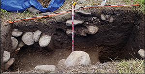
This simple architecture comprises single- or double-course stone alignments (Figure 7a). We interpret these features as barrage terraces or checkdams designed to trap fine alluvium in order to create a stable, stream-side landform. Judging by the accumulation of finer sediments above these features (Figure 7b), the terraces successfully trapped sediment carried by natural depositional processes such as overbank flooding. Our Bayesian model indicates that the transition from predominantly coarse to fine sediment deposition occurred in AD 1321–1370 (95.4%). The accumulation of fine sediment laid the foundation for intensive agriculture at the site, and the rate of infrastructure construction accelerated markedly in the fifteenth century (Figures 6 & 8). This infrastructure is more elaborate, most notably earthen terraces with stone-faced retaining walls (Figure 7c). The rate of construction declined in the seventeenth century, presumably because the system continued to produce regular yields; indeed, the consistent presence of charcoal into and beyond the seventeenth century suggests the continued use of the system. Based on the lack of historical land claims recorded for this location, the pondfields were probably abandoned by the mid-nineteenth century due to population decline following Western contact. Historical maps, however, depict the area as being under rice cultivation by the latter part of the nineteenth century and into at least the first decade of the twentieth century. By the 1920s, historical maps indicate that taro was again being cultivated but this may have been a short-lived phase.

Figure 7. a) Small-scale boulder alignment at the base of Trench 7; note the position of the alignment among smaller alluvial cobbles. b) The relationship between fine and coarse alluvial sediments visible in Trench 6; both walls were built in the upper fine sediments. c) The surface and buried retaining wall of Trench 9; the lower wall was built on top of coarse alluvial deposits (figure by Seth Quintus).

Excavations on the colluvial slope have revealed single-phase construction sequences, with the potential exception of the ritual compound or heiau (Morrison et al. Reference Morrison2022). Direct dating of archaeobotanical remains highlights the incorporation of some arboreal elements into the subsistence system by the fifteenth century, including breadfruit (Artocarpus altilis, ‘ulu), coconut (Cocos nucifera, niu) and candlenut (Aleurites moluccana, kukui) (Morrison et al. Reference Morrison2022). The building of infrastructure commenced as early as AD 1302–1659 (95.4%) but the bulk of activity occurred later, from the sixteenth to eighteenth centuries (Figures 6 & 8). Several linear mounds and terrace-retaining walls abut other features, and therefore post-date them, highlighting a process of field segmentation over time. Ladefoged et al. (Reference Ladefoged, McCoy, Asner, Kirch, Puleston, Chadwick and Vitousek2011) argue that such a process is the archaeological signature of rain-fed intensification, wherein more agricultural labour supported by a higher population was invested in agricultural practices. If this same argument holds for the colluvial slopes, it would highlight the role that population size plays in enhancing the utility of these environments. The tempo plot highlights the continued use of these systems until the nineteenth century. There are no historical records or archaeological evidence for later cultivation of this area. The preservation of this complex relates to its unsuitability for nineteenth- and twentieth-century commercial agriculture in the valley, which often resulted in the wholesale removal of earlier surface structures.

The developmental sequences reconstructed for the alluvial plain and the colluvial slopes can be compared using tempo plots (Figure 8). Initial development of agricultural systems on the alluvial plain at some time prior to the mid-fourteenth century was followed by 200 years of intensive development. Activities on the colluvial slopes at this time were restricted to the planting of introduced tree crops and, by the end of the period, the initial construction of infrastructure. Some form of shifting cultivation prior to the building of infrastructure cannot be ruled out, though there is no direct evidence and little charcoal was found beneath agricultural infrastructure in either the colluvial or irrigated environments. By the sixteenth century, the development of the pondfield system slowed as existing terraces were subdivided and new terraces were added at the margins of the system. The development of infrastructure on the colluvial slopes accelerated in the sixteenth century and continued through to the early nineteenth century.

Figure 8. Tempo plot comparing the construction of infrastructure across the lo‘i (top) and colluvial slopes (bottom) (figure by Tom Dye).

The evolution of Hawaiian valley agriculture

Our data allow us to assess the expectations and hypotheses set out above (Figure 1). The sequence of development on the alluvial plain and colluvial slopes of Punaluʻu meets the expectations derived from an ideal free distribution model where suitability is determined by potential yield per unit effort: initial investment in high-yield irrigated agriculture on the alluvial plain is followed by the development of agricultural infrastructure for lower-yield dryland crops on the colluvial slopes. These sequences indicate a change in the relative suitability of the alluvial plain and colluvial slopes over a period of time.

The suitability of novel habitats for human settlement on islands is largely conditioned by the subsistence techniques and crops introduced from elsewhere. In the case of Hawai‘i, Polynesian settlers initially brought crops that were well suited for tropical environments, having been domesticated and selectively propagated in these settings for millennia. It is unsurprising that irrigated agriculture was quickly established as the islands’ well-watered environment would have been familiar to the Polynesian settlers and the use of irrigation was known to be the highest-yielding strategy.

The earliest infrastructure appears to have been geared toward stabilising a dynamic environment: the banks or shallow sections of a permanent river. In addition to creating arable land, the consequence of this infrastructure was the enhancement of the location for later pondfield development and its expansion by the trapping of sediment. We hypothesise that the building of infrastructure initiated a positive feedback loop, wherein the trapping of fine sediments led to increased suitability for cultivation and continued elaboration of the agricultural system. Habitat suitability was enhanced by infrastructure that accumulated fine sediments leading to aggradation (increased height of the landform), which would have reduced the effects of erosive flooding. Such processes are similarly hypothesised for other irrigated environments in the archipelago (Kirch Reference Kirch2002; McCoy et al. Reference McCoy, Browne Ribeiro, Graves, Chadwick and Vitousek2013). It is conceivable that sediment movement was aided by the practice of shifting (or swidden) cultivation elsewhere in the valley, as noted by Spriggs (Reference Spriggs, Kirch and Hunt1997), but we currently lack data to confirm this. The result was productive resilience, at the cost of increased, but generally predictable, maintenance (McCoy et al. Reference McCoy, Browne Ribeiro, Graves, Chadwick and Vitousek2013: 1537). Such processes highlight the role of anthropogenic construction in changing habitat suitability (Bliege Bird et al. Reference Bliege Bird, McGuire, Bird, Price, Zeanah and Nimmo2020).

Agricultural development of the colluvial slope was due, in part, to population growth resulting from expanded production on the valley bottom, as predicted from an ideal free distribution model and as proposed more generally to explain increased investment in rain-fed agriculture across the archipelago (Ladefoged & Graves Reference Ladefoged and Graves2008; Kirch Reference Kirch2010). Rain-fed production requires more labour per land unit, relative to wetland production, to produce a similar yield (Kirch Reference Kirch1994). As such, the suitability of the colluvial slope environment would have increased only as the labour force grew or as the yields from irrigation decreased. In this context, it is notable that the early period of cultivation on the slopes included some tree crops grown with limited infrastructure (Morrison et al. Reference Morrison2022). This indicates an initial phase of relatively low-labour-intensity perennial cultivation prior to the institution of more labour-intensive annual cultivation evidenced by field boundaries. As tree crops persisted and the workforce grew, colluvial slopes may have attracted more farmers whose labour enhanced the suitability of the environment through an Allee effect. In conjunction, absolute surplus production would have increased. While the surplus production per worker across colluvial slopes, as modelled by Kurashima & Kirch (Reference Kurashima and Kirch2011), is not as high as for pondfields, the absolute surplus produced may have rivalled that of the irrigated facilities if a large enough workforce were available to put the slopes around the entire valley into production. In this regard, we note that the colluvial slopes were developed after power became further consolidated by elites on Oʻahu (Kirch Reference Kirch2010). The growth of polities and elite presence may have enhanced colluvial slope suitability as elites pushed for surplus production to support a growing wealth economy (Dye Reference Dye2014). On that note, and as predicted above, positive despotism was another factor affecting investments in the system. The construction of a large heiau (AD 1525–1764) that is physically connected to the agricultural infrastructure (Morrison et al. Reference Morrison2022) highlights that elites were interested in the colluvial slope landscape.

These developments occurred in conjunction with the introduction of the sweet potato (McCoy Reference McCoy2006; Morrison et al. Reference Morrison2022). Compared with the 1500–2000mm annual rainfall required to grow dryland taro, sweet potato is a more drought-tolerant crop, needing only 500–750mm of rain annually, with approximately 90mm of rain in the month of crop establishment. The near-coastal colluvial slopes of Punalu‘u receive an average of 1500mm of annual rainfall (Giambelluca et al. Reference Giambelluca, Chen, Frazier, Price, Chen, Chu, Eischeid and Delparte2013), which would support only the marginal cultivation of taro. The earliest-recorded sweet potato macrobotanical remains in the archipelago probably date to the fourteenth century, but could be as late as the fifteenth century (Ladefoged et al. Reference Ladefoged, Graves and Coil2005), with our model providing a date of 1300–1426 (see OSM). As noted by Ladefoged & Graves (Reference Ladefoged and Graves2000), experimentation with sweet potatoes, including varietal development, was necessary prior to any high-intensity production. Once that knowledge was gained, and while dryland sweet-potato production would still yield far less than wetland taro per unit of labour, the presence of sweet potato made colluvial slopes far more suitable for other uses too. This is consistent with not only increased production but also a risk-aversion strategy (Allen Reference Allen2004). Diversifying crops, cultivation methods and field locations within Punalu‘u Valley could have reduced the effects of interannual variation. Like geomorphological change, the introduction of new crops speaks to the role of cultural practice in effectively resetting suitability calculations. It was, however, the combination of a larger labour pool made possible by investment in irrigation, the introduction of the sweet potato and changes in social organisation that made colluvial and leeward slopes more attractive for agricultural exploitation. The eventual importance of sweet potato cultivation in Punaluʻu was the result of the prior development of irrigation in the valley.

Indigenous agricultural practices were abandoned along these colluvial slopes shortly after the arrival of Europeans. In contrast, the use of irrigation persisted through the historical period, including in the Punalu‘u valley. This meets another expectation of the ideal free distribution model in a situation of population decline. The reduction in use of colluvial slopes and the increasing suitability of valley lowlands for cultivation was probably also driven by the abolition of traditional tribute demands, the reduced social importance of pigs (fed by crop surpluses), the initiation of a cash economy and the cultivation of rice and other introduced crops.

Ideal distribution models help us better understand the drivers of agricultural change and relationships between agricultural techniques in Punaluʻu, despite some inconsistencies in the predictions. A negative despotism model would predict that evidence of territoriality would be found in irrigated environments. There is, however, no such evidence from Punaluʻu, where possible markers of elite activities (e.g. the large heiau) are located in proximity to colluvial slope systems. This does not imply that negative despotism was absent, as some forms of territoriality do not leave material traces, but it does highlight the potential importance of positive despotism in dryland environments where a large labour force was crucial. Further, as currently constructed, ideal distribution models are less effective at incorporating notions of anthropogenic change. The Allee effect includes some elements of anthropogenic change, but it is most frequently cited in the context of labour and group size rather than transgenerational ecological inheritance (e.g. environment and crops). In Punaluʻu, both exchange and engineering altered habitat suitability. As such, the incorporation of these dynamics, along with social and political factors, could further improve the utility of ideal distribution models (Prufer et al. Reference Prufer, Thompson, Meredith, Culleton, Jordan, Ebert, Winterhalder and Kennett2017; Bliege Bird Reference Bliege Bird, McGuire, Bird, Price, Zeanah and Nimmo2020).

Conclusions

While demography is typically seen to be variable, other factors that affect habitat suitability in ideal distribution models tend to be treated as constants (Weitzel & Codding Reference Weitzel and Codding2020). Such fixed suitability in any particular environment, however, is rare. The actions of farmers create conditions that shape future opportunities and constraints, through the incorporation of alternative crops, the expansion of arable land or the development of agricultural infrastructure (Quintus & Cochrane Reference Quintus and Cochrane2018). By doing so, as our study illustrates, the relative suitability of environments is modified. Data from Punalu‘u highlight an early use of environments conducive to irrigation, with subsequent iterations of land use gradually enhancing the suitability of these agricultural habitats. Infrastructural-based investment in dryland areas were a later development, possibly driven by a combination of population growth, the introduction of a new crop (the sweet potato), risk management efforts and the growth of a large-scale political economy.

The temporal depth of these practices provides important insights into their contemporary revitalisation. Pondfield systems are resilient because, when skilfully managed, they are habitat enhancing. This is not necessarily the case for the rain-fed systems that were developed after the sweet potato was introduced to the islands; farmers mastered its cultivation, and a large labour force became available to support the expansion of its cultivation. The rain-fed systems, however, were abandoned shortly after the arrival of Europeans. The differences in how these systems were viewed and used in the past makes an important contribution for ongoing conversations around present-day agricultural revitalisation in the Hawaiʻi archipelago.

Acknowledgements

We acknowledge the support of the Punaluʻu community during this research as well as the students and staff involved in the success of iterations of the Punaluʻu field schools.

Funding statement

Funding for this research was provided by Kamehameha Schools.

Supplementary material

To view supplementary material for this article, please visit https://doi.org/10.15184/aqy.2023.121.

References

Allee, W.C. 1931. Animal aggregations, a study in general sociology. Chicago (IL): University of Chicago Press. https://doi.org/10.5962/bhl.title.7313CrossRefGoogle Scholar
Allen, M.S. 2004. Bet-hedging strategies, agricultural change, and unpredictable environments: historical development of dryland agriculture in Kona, Hawaii. Journal of Anthropological Archaeology 23: 196224. https://doi.org/10.1016/j.jaa.2004.02.001CrossRefGoogle Scholar
Athens, J.S., Rieth, T.M. & Dye, T.S.. 2014. A paleoenvironmental and archaeological model-based age estimate for the colonization of Hawaiʻi. American Antiquity 79: 144–55. https://doi.org/10.7183/0002-7316.79.1.144CrossRefGoogle Scholar
Barrau, J. 1965. L'humide et le sec: an essay on ethnobiological adaptation to contrastive environments in the Indo-Pacific area. Journal of the Polynesian Society 74: 329–46.Google Scholar
Bayman, J.M., Dye, T.S. & Rieth, T.M.. 2021. States without archaeological correlates? A report from Hawaiʻi. Journal of Pacific Archaeology 4: 4771.Google Scholar
Bell, A.V. & Winterhalder, B.. 2014. The population ecology of despotism: concessions and migration under the ideal despotic distribution. Human Nature 25: 121–35. https://doi.org/10.1007/s12110-014-9190-7CrossRefGoogle Scholar
Bliege Bird, R., McGuire, C., Bird, D.W., Price, M.H., Zeanah, D. & Nimmo, D.G.. 2020. Fire mosaics and habitat choice in nomadic foragers. Proceedings of the National Academy of Sciences USA 117: 12904–14. https://doi.org/10.1073/pnas.1921709117CrossRefGoogle ScholarPubMed
Bronk Ramsey, C. 2009. Bayesian analysis of radiocarbon dates. Radiocarbon 51: 337–60. https://doi.org/10.1017/S0033822200033865CrossRefGoogle Scholar
Dye, T.S. 2014. Wealth in old Hawaiʻi: good-year economics and the rise of pristine states. Archaeology in Oceania 49: 5985. https://doi.org/10.1002/arco.5034CrossRefGoogle Scholar
Dye, T.S. 2016. Long-term rhythms in the development of Hawaiian social stratification. Journal of Archaeological Science 71: 19. https://doi.org/10.1016/j.jas.2016.05.006CrossRefGoogle Scholar
Fretwell, S.D. & Lucas, H.L.. 1969. On territorial behavior and other factors influencing habitat distribution in birds. Acta Biotheoretica 19: 1636. https://doi.org/10.1017/S0033822200033865CrossRefGoogle Scholar
Giambelluca, T.W., Chen, Q., Frazier, A.G., Price, J.P., Chen, Y.-L., Chu, P.-S., Eischeid, J.K. & Delparte, D.M.. 2013. Online rainfall atlas of Hawai'i. Bulletin of the American Meteorological Society 94: 313–6. https://doi.org/10.1175/BAMS-D-11-00228.1CrossRefGoogle Scholar
Handy, E.S.C., Handy, E.G. & Pukui, M.K.. 1972. Native planters in Old Hawaii: their life, lore, and environment (B.P. Bishop Museum Bulletin 233). Honolulu (HI): Bishop Museum Press.Google Scholar
Hommon, R.J. 2013. The ancient Hawaiian state: origins of a political society. Oxford: Oxford University Press. https://doi.org/10.1093/acprof:oso/9780199916122.001.0001CrossRefGoogle Scholar
Jazwa, C.S. & Jazwa, K.A.. 2017. Settlement ecology in Bronze Age Messenia. Journal of Anthropological Archaeology 45: 157–69. https://doi.org/10.1016/j.jaa.2016.12.003CrossRefGoogle Scholar
Kennett, D., Anderson, A. & Winterhalder, B.. 2006. The ideal free distribution, food production, and the colonization of Oceania, in Kennett, D.J. & Winterhalder, B. (ed.) Behavioral ecology and the transition to agriculture: 265–88. Berkeley: University of California Press. https://doi.org/10.1525/9780520932456-015Google Scholar
Kirch, P.V. 1977. Valley agricultural systems in prehistoric Hawaii: an archaeological consideration. Asian Perspectives 20: 246–80.Google Scholar
Kirch, P.V. 1994. The wet and the dry: irrigation and agricultural intensification in Polynesia. Chicago (IL): University of Chicago Press.Google Scholar
Kirch, P.V. 2002. From the ‘cliffs of Keōlewa’ to the ‘sea of Papaloa’: an archaeological reconnaissance of portions of the Kalaupapa National Historical Park, Molokaʻi, Hawaiian Islands. Berkeley: Contributions of the University of California Archaeological Research Facility.Google Scholar
Kirch, P.V. 2010. How chiefs became kings: divine kingship and the rise of archaic states in ancient Hawai'i. Berkeley: University of California Press. https://doi.org/10.1525/9780520947849CrossRefGoogle Scholar
Kurashima, N. & Kirch, P.V.. 2011. Geospatial modeling of pre-contact Hawaiian production systems on Moloka'i Island, Hawaiian Islands. Journal of Archaeological Science 38: 3662–74. https://doi.org/10.1016/j.jas.2011.08.037CrossRefGoogle Scholar
Ladefoged, T.N. & Graves, M.W.. 2000. Evolutionary theory and the historical development of dry land agriculture in North Kohala, Hawai'i. American Antiquity 65: 432–48. https://doi.org/10.2307/2694529CrossRefGoogle Scholar
Ladefoged, T.N. & Graves, M.W.. 2008. Variable development of dryland agriculture in Hawai'i: a fine-grained chronology from the Kohala Field System, Hawai'i Island. Current Anthropology 49: 771802. https://doi.org/10.1086/591424CrossRefGoogle Scholar
Ladefoged, T.N., Graves, M.W. & Coil, J.H.. 2005. The introduction of sweet potato in Polynesia: early remains from Hawaiʻi. Journal of the Polynesian Society 114: 359–73.Google Scholar
Ladefoged, T.N., Kirch, P.V., Gon, S.M., Chadwick, O.A., Hartshorn, A.S. & Vitousek, P.M.. 2009. Opportunities and constraints for intensive agriculture in the Hawaiian archipelago prior to European contact. Journal of Archaeological Science 36: 2374–83. https://doi.org/10.1016/j.jas.2009.06.030CrossRefGoogle Scholar
Ladefoged, T.N., McCoy, M.D., Asner, G.P., Kirch, P.V., Puleston, C.O., Chadwick, O.A. & Vitousek, P.M.. 2011. Agricultural potential and actualized development in Hawaiʻi: an airborne LiDAR survey of the leeward Kohala field system (Hawaiʻi Island). Journal of Archaeological Science 38: 3605–19. https://doi.org/10.1016/j.jas.2011.08.031CrossRefGoogle Scholar
McCoy, M.D. 2006. Landscape, social memory, and society: an ethnohistoric-archaeological study of three Hawaiian communities. Unpublished PhD dissertation, University of California.Google Scholar
McCoy, M.D., Browne Ribeiro, A.T., Graves, M.W., Chadwick, O.A. & Vitousek, P.M.. 2013. Irrigation taro (Colocasia esculenta) farming in North Kohala, Hawai'i. Sedimentology and soil nutrient analyses. Journal of Archaeological Science 40: 1528–38. https://doi.org/10.1016/j.jas.2012.08.028CrossRefGoogle Scholar
McElroy, W.K. 2007. The development of irrigated agriculture in Wailau Valley, Moloka'I Island, Hawai'i. Unpublished PhD dissertation, University of Hawai'i, Manoa.Google Scholar
Morrison, A. et al. 2022. Colluvial slope agriculture in context: an extensive agricultural landscape along the slopes of Punalu'u Valley, O'ahu Island, Hawai'i. Journal of Island and Coastal Archaeology. https://doi.org/10.1080/15564894.2021.1998936CrossRefGoogle Scholar
Philippe, A., Vibet, M. & Dye, T.S.. 2017. ArchaeoPhases: post-processing of the Markov Chain simulated by ‘ChronoModel’, ‘Oxcal’ or ‘BCal’. R Package Version 1.Google Scholar
Prufer, K.M., Thompson, A.E., Meredith, C.R., Culleton, B.J., Jordan, J.M., Ebert, C.E., Winterhalder, B. & Kennett, D.J.. 2017. The Classic Period Maya transition from an ideal free to an ideal despotic settlement system at the polity of Uxbenkãi. Journal of Anthropological Archaeology 45: 5368. https://doi.org/10.1016/j.jaa.2016.11.003CrossRefGoogle Scholar
Quintus, S. & Cochrane, E.E.. 2018. The prevalence and importance of niche construction in agricultural development in Polynesia. Journal of Anthropological Archaeology 51:173–86. https://doi.org/10.1016/j.jaa.2018.06.007CrossRefGoogle Scholar
Quintus, S. & Lincoln, N.K.. 2020. Integrating local and regional in pre-contact Hawaiian agriculture at Kahuku, Hawai'i Island. Environmental Archaeology 25: 5368. https://doi.org/10.1080/14614103.2018.1497833CrossRefGoogle Scholar
Rieth, T.M. & Tomonari-Tuggle, M.J.. 2013. Anything but hardscrabble: an archaeological inventory survey of a colluvial slope agricultural complex; Kalaupapa Pali Trail Survey, Kalaupapa National Historical Park, Kalaupapa Ahupua'a, Ko'olau District, Moloka'i. Report prepared for the National Park Service.Google Scholar
Rieth, T.M., Quintus, S., Filimoehala, C.W., Filimoehala, D. & Dye, T.S.. 2021. Archaeological data recovery at site 50-80-06-2936, Punalu'u Ahupua'a, Ko'olauloa Moku, O'ahu. Report prepared for Kamehameha Schools Wahi Kūpuna Program.Google Scholar
Spriggs, M. 1997. Landscape catastrophe and landscape enhancement: are either or both true in the Pacific? In Kirch, P.V. & Hunt, T.L. (ed.) Historical ecology in the Pacific Islands: 80104. New Haven (CT): Yale University Press. https://doi.org/10.2307/j.ctt211qz1v.10CrossRefGoogle Scholar
Summers, K. 2005. The evolutionary ecology of despotism. Evolution and Human Behavior 26:106–35. https://doi.org/10.1016/j.evolhumbehav.2004.09.001CrossRefGoogle Scholar
Vitousek, P.M., Ladefoged, T.N., Kirch, P.V., Hartshorn, A.S., Graves, M.W., Hotchkiss, S.C., Tuljapurkar, S. & Chadwick, O.A.. 2004. Soils, agriculture, and society in precontact Hawai'i. Science 304: 1665–9. https://doi.org/10.1126/science.1099619CrossRefGoogle ScholarPubMed
Weitzel, E.M. & Codding, B.F.. 2020. The ideal free distribution model and archaeological settlement patterning. Environmental Archaeology 27: 349–56. https://doi.org/10.1080/14614103.2020.1803015CrossRefGoogle Scholar
Winterhalder, B., Kennett, D.J., Grote, M.N. & Bartruff, J.. 2010. Ideal free settlement of California's Northern Channel Islands. Journal of Anthropological Archaeology 29: 469–90. https://doi.org/10.1016/j.jaa.2010.07.001CrossRefGoogle Scholar
Figure 0

Figure 1. Rules, expectations, signatures and results for agricultural development in Punaluʻu derived from ideal distribution models (figure by Seth Quintus).

Figure 1

Figure 2. The location of Punaluʻu on Oʻahu. The dark line is the shoreline, while the lighter lines are 100m contours (figure by Seth Quintus).

Figure 2

Figure 3. Location of the two agricultural systems in Punalu‘u Valley. The dark line is the shoreline and the light lines are 40m contours (figure by Seth Quintus).

Figure 3

Figure 4. Plan view map of the loʻi complex with trench locations. The stream is located to the north of the system and the intake ditch is located to the south (figure by Chris Filimoehala).

Figure 4

Figure 5. Modelled radiocarbon dates associated with relevant colluvial slope and irrigated infrastructure in Punaluʻu (figure by Seth Quintus).

Figure 5

Figure 6. Estimated construction ages for 22 features across the colluvial slopes and irrigated systems (figure by Seth Quintus).

Figure 6

Figure 7. a) Small-scale boulder alignment at the base of Trench 7; note the position of the alignment among smaller alluvial cobbles. b) The relationship between fine and coarse alluvial sediments visible in Trench 6; both walls were built in the upper fine sediments. c) The surface and buried retaining wall of Trench 9; the lower wall was built on top of coarse alluvial deposits (figure by Seth Quintus).

Figure 7

Figure 8. Tempo plot comparing the construction of infrastructure across the lo‘i (top) and colluvial slopes (bottom) (figure by Tom Dye).

Supplementary material: File

Quintus et al. supplementary material

Quintus et al. supplementary material 1

Download Quintus et al. supplementary material(File)
File 23.2 KB
Supplementary material: File

Quintus et al. supplementary material

Quintus et al. supplementary material 2

Download Quintus et al. supplementary material(File)
File 2 MB
Supplementary material: File

Quintus et al. supplementary material

Quintus et al. supplementary material 3

Download Quintus et al. supplementary material(File)
File 12.9 KB
Supplementary material: File

Quintus et al. supplementary material

Quintus et al. supplementary material 4

Download Quintus et al. supplementary material(File)
File 1.9 MB