


Introduction
Medieval villages are a key element in the contemporary collective imaginaries about the Middle Ages in Europe. In video games and films, the image of a chivalrous yet violent past persists as the popular view of this period. Recent scholarship on medieval history and archaeology, however, has highlighted the contingent and changing nature of villages over the long term, addressing perennial problems such as the formation and transformation of village networks and the abandonment of late-medieval village landscapes. Although our analytical methods and chronological resolution have considerably improved, the theoretical frameworks within which historians and archaeologists work continue to rely on problems defined long ago. A better comprehension of medieval-village formation requires not only the implementation of better methods and the acquisition of more precise settlement chronologies, but also the adoption of a new theoretical framework based on a social, flexible and practice-orientated concept of community. Moreover, while recent study of agrarian spaces has opened new interpretative avenues regarding agricultural practices, rural landscapes, environmental transformations and social dynamics (Quirós Castillo Reference Quirós Castillo2014; Schreg Reference Schreg2014), these agroscapes have not yet been analysed from the perspective of village formation.
In this article, we examine some key examples of agroscapes, both with and without associated villages, in northern Iberia to investigate long-term collective action and agricultural practices dating back to the early medieval period. The integration of geoarchaeology, settlement patterns, architecture, textual sources and placename evidence within a historical-ecological framework allows us to consider collective action and its effects on the materiality of the local landscape.
Across Europe, research on early medieval village formation is highly conditioned, and segmented, by national traditions that focus on different historical trends and themes. In France, village formation has been identified as the stabilisation of dispersed settlements of early medieval origin c. AD 1000 through ‘banal seigneuries’ and the emergence of powerful territorial lordships (Chapelot & Fossier Reference Chapelot and Fossier1980). The results of the recent upsurge of rescue or developer-led archaeology, however, challenge this explanation by demonstrating that the first villages emerged at an earlier date and evolved within different social and political contexts. Recent research has also documented notable regional diversity alongside the generally accepted distinction between the landscapes of the north of the country and the Mediterranean south (Passarrius & Catafau Reference Passarrius and Catafau2018; Peytremann Reference Peytremann, Effros and Moreira2020; Favory et al. Reference Favory, Mathian, Schneider, Raynaud and Sanders2021).
In Britain, research has focused on the creation of villages, and common fields. Since Hoskins’ classic work in Reference Hoskins1955, the origins of this binomial have constituted one of the basic research topics of British medievalism. More generally, a combination of regional studies, environmental analyses and developer-led archaeology has documented notable geographical and typological diversity of medieval villages and field systems (Roberts & Wrathmell Reference Roberts and Wrathmell2002; Rippon Reference Rippon2006). Recent studies suggest that the formalisation and regionalisation of rural settlements date to the Middle Anglo-Saxon period, in a context of an ‘agricultural revolution’ (McKerracher & Hamerow Reference McKerracher and Hamerow2022); the emergence of mature medieval villages is dated to the Late Anglo-Saxon period (Christie & Stamper Reference Christie and Stamper2012), although some historical actors anticipated this process (Hinton et al. Reference Hinton, Crawford and Hamerow2011; Oosthuizen Reference Oosthuizen2019). Nonetheless, the exact relationships between villages, common fields and communities remain a matter of debate (Dyer et al. Reference Dyer, Thoen and Williamson2018).
In the western Mediterranean, attention has focused primarily on incastellamento. According to this narrative, the establishment of seigneurial powers in the tenth and eleventh centuries AD is reflected in the concentration of population in fortified hilltop centres within new micro-territories of seigneurial domination (Toubert Reference Toubert1973). The investigation of medieval fortified sites has, however, shown that incastellamento was but one stage in a longer process of settlement concentration that began in the Early Middle Ages (Francovich & Hodges Reference Francovich and Hodges2003; Molinari Reference Molinari2010; Augenti & Galetti Reference Augenti and Galetti2018).
Finally, in Iberia, village formation has long been addressed in the context of the Reconquista—the expulsion of the Muslim population and replacement by Christian settlers from the north. Since the 1980s, this model of repopulation has been replaced by one of colonisation, stressing the differences in social and economic status between lords and peasants (Escalona & Martín Viso Reference Escalona, Martín Viso, Barton and Portass2020). Most recently, the development of an archaeology of rural spaces has permitted alternative interpretative frameworks to emerge, more radically reconceptualising the notion of villages and rural settlements in Iberia (Vigil-Escalera Guirado Reference Vigil-Escalera Guirado2007; Quirós Castillo Reference Quirós Castillo2016). In summary, across various western European contexts, there is a consensus that the Early Middle Ages (sixth–tenth centuries) was a critical moment in the development of villages.
But what is a medieval village? The influential work of É. Zadora-Rio (Reference Zadora Rio and Mornet1995) showed that European scholars maintained two parallel definitions of the medieval village. Among historians, the village was (textually) defined by institutionalised foci of attachment, such as church, cemetery and castle; in contrast, archaeologists defined the village as a group of houses (Zadora-Rio Reference Zadora Rio and Mornet1995). The ‘landscape turn’ of the past 25 years has, however, seen archaeologists engage in a deep theoretical reconceptualisation of village landscapes. As a result, more detailed archaeological proxies have been generated and new topics addressed, including rural economies, the relationship between villages and towns, the perceptions and experiences of villagers, the local negotiation of power and the governance of common goods (Stagno Reference Stagno2017; Mileson & Brookes Reference Mileson and Brookes2021). Yet, paradoxically, these developments have fragmented the notion of the village into a heterogeneous universe of concept and realities, challenging rather than resolving the dialogue between the disciplines. Hence, while historians emphasise the political, morphological and institutional dimension of villages (Zadora-Rio Reference Zadora Rio and Mornet1995; Carvajal Castro Reference Carvajal Castro2021), archaeologists increasingly address themes of collective creation and regulation and transformation of agro-silvo-pastoral resources in shaping shared identities and community-based social life (Peytremann Reference Peytremann2015; Oosthuizen Reference Oosthuizen2016).
To address these challenges, we propose, first, a reconsideration of the theoretical definition of community and, second, the analysis of the material correlates of communities beyond domestic settings. These issues may be partially addressed from theoretical perspectives, such as collective action theory (DeMarrais & Earle Reference DeMarrais and Earle2017) or the archaeology of communities (Canuto & Yaeger Reference Canuto and Yaeger2000; Gerritsen Reference Gerritsen and Bintliff2006), whose potential for the study of medieval communities has barely been explored. As a result, the notion of ‘village’ can be reshaped in relational terms and shared identities defining communities of practice (Wenger Reference Wenger1999). In particular, the methodological and intellectual dominance of settlement archaeology has relegated the significance of agricultural spaces, viewing them as an inevitable consequence of the creation of communities rather than as an integral component in the successful formation of a settlement. In this article, we argue that consideration of these agroscapes offers an important avenue for challenging and reshaping the mainstream notion of the medieval village.
Villages and agroscapes in northern Iberia: Tobillas
Tobillas is a small village, consisting of a dozen houses, within the narrow valley of the Omecillo river, a tributary of the Ebro, in the western Basque Country (Figure 1). It is an important location as one of few places in north-western Iberia that combines historical documentation, archaeological investigations and extant early medieval religious buildings. Consequently, Tobillas offers an ideal case study for a historical-archaeological project focused on the village formation processes. Additionally, it might be considered to be a ‘typical’ village, having features in common with many other settlements in the region, which presents the possibility for extrapolating the results of our analysis to other villages.

Figure 1. Map of early medieval occupations in the Gaubea valley. Corro cave occupations (sixth to seventh century AD); Villamanca, Basabe and Valluerca villages (ninth century); San Juan and Santa Olaria necropolis (ninth to tenth century); San Román de Tobillas (ninth century); San Miguel de Corro (ninth to tenth century); and Valluerca (tenth to eleventh century) (figure by Josu Narbarte).
Today, extensive agricultural fields are found only on the valley floodplains; the surrounding mountain slopes are forested. As at other nearby locations, local toponyms or placenames are of medieval origin, carrying the memory of past agro-pastoral land use: vineyards—El Majuelo, La Viña, Parral; new intakes of lands—Cerradíos, La Cerrada; orchards and gardens—La Herrán, Manzanal. Among these placenames is La Serna, which is attached to a 10ha agricultural area on the Omecillo floodplain. Comprising characteristic strip-shaped parcels of land, orientated perpendicular to the river, the area is drained by a channel, protected by a flood bank and partially delimited with boundary stones (Figure 1).
The term serna appears in the documentary sources of northern Iberia from the ninth century (García de Cortázar Reference García de Cortázar1980; Botella Pombo Reference Botella Pombo1988). Although it can have multiple meanings, the term refers primarily to a cereal field managed collectively or semi-collectively. Sernas are usually mentioned as belonging to elites, including kings, but two different levels of ownership can be inferred from the written evidence: local households owning subplots linked to neighbourhood use rights, and a higher order of ownership overseen by elites intended to protect the community against unwanted interference (e.g. from external agents) in return for an income and patronage rights (Martín Viso Reference Martín Viso2020).
The importance of sernas in the early medieval agricultural landscapes of Tobillas, and in the surrounding region, is well documented in the written sources, which are relatively abundant here by the standards of Castile. When the private church of San Román was founded in AD 822, it was provided with several land properties, including sernas and bustos (pastures), extending over 6km2 around the village of Tobillas. The foundation charter appealed to a narrative of colonisation, rhetorically legitimising the appropriation of an allegedly barren land (Larrea Reference Larrea, López-Quiroga, Martínez-Tejera and Morín de Pablos2007). In fact, archaeological investigation has shown the existence of several early medieval activity foci in the area of Tobillas, including cave occupations, funerary areas and domestic settlement. Of particular significance are the three early medieval churches of Tobillas, Corro and Valluerca, which have been dated by their building sequences and techniques (Sánchez Zufiaurre Reference Sánchez Zufiaurre2007; Figure 2). Based on the radiocarbon dating of a burial at the Cueva de los Moros at Corro, the cave was in use during the sixth to seventh centuries (Sáez de Urturi Reference Sáez de Urturi1990). Activity at other nearby villages has also been dated on the basis of written sources (Larrea Reference Larrea, López-Quiroga, Martínez-Tejera and Morín de Pablos2007) or the typology of funerary spaces (Martín Viso Reference Martín Viso and Barroca2021) (Figure 1). Here, we explore the cultural biography of La Serna in order to characterise the foundation and development of a representative agricultural area managed collectively since, at least, the Early Middle Ages.

Figure 2. Construction sequence of the San Román de Tobillas church, according to Sánchez Zufiaurre (Reference Sánchez Zufiaurre2007, figure 128) (figure with permission of Leandro Sánchez Zufiaurre).
Materials and methods
The recent archaeological study of agrarian spaces has revealed the potential of such an approach for addressing the complexity of the social practices related to the management of land and agricultural resources in the Early Middle Ages (Narbarte-Hernández & Rodríguez-Lejarza Reference Narbarte-Hernández, Rodríguez-Lejarza, Pulido, Campo, Cabes and Le Couédic2022). The construction and maintenance of extensive, consolidated agrarian spaces required the coordinated collective action of one or more social groups, the material expression of which may be observed in the landscape in various forms, including the organisation of boundaries and facilities, and topographical, hydrographic and geomorphological modifications resulting from agricultural practices. The identification and analysis of these features can broaden our understanding of the social relationships that shaped historical—and present-day—landscapes.
To this end, we have explored the agrarian landscape of the village of Tobillas with a two-stage methodology. First, we conducted an extensive survey of La Serna to document: the topography and hydrography of the area; the morphology of the strip-parcel system; local placenames; and evidence for agricultural management practices such as ploughing or manuring. The resulting data were collated in a GIS database and analysed to identify areas particularly influenced by anthropic activity, and thus to reconstruct the cultural biography of this agricultural area (Figure 3).

Figure 3. General view of La Serna with the village of Tobillas in the background (photograph by Josu Narbarte).
Second, we sampled the soils of La Serna for geoarchaeological analysis. Two sediment cores (TOB/1 and TOB/2) were collected from the area to help characterise topographic and hydrographic change resulting from agricultural management of the land (Figure 4). Visual inspection confirms the similarity of the two core sequences. Core TOB/1 was sampled at intervals of 50mm to facilitate a detailed geoarchaeological characterisation, conducted at the Science and Technology Park of the University of Burgos. X-ray fluorescence (XRF) analyses were carried out with the aim of measuring the weight percentage (wt. %) of different chemical elements in each sediment sample. The weight percentage of organic carbon in the samples was measured through the Loss on Ignition (LOI) technique (Heiri et al. Reference Heiri, Lotter and Lemcke2001).
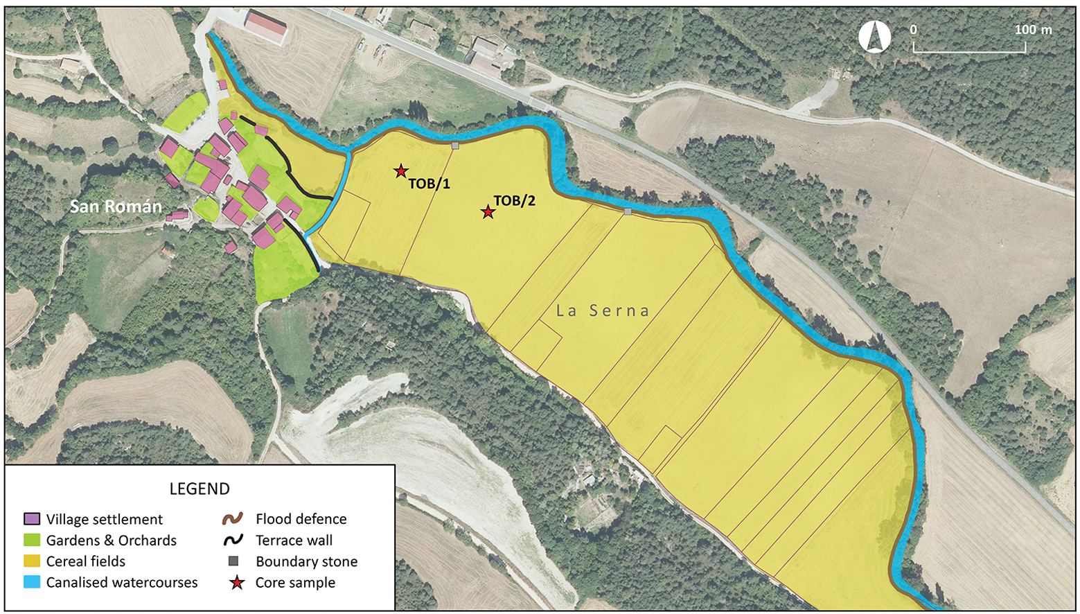
Figure 4. Aerial view of modern land uses and structures in the La Serna area (Tobillas) and illustrations showing the locations of the cores (figure by Josu Narbarte).
The XRF and LOI data were cleaned and analysed using principal component analysis (PCA; Hotelling Reference Hotelling1933). This technique reduces the dimensionality of variables to a smaller number of principal components that explain as much of the variability in the data as possible. In this case, the PCA permits the identification of the most important environmental and anthropogenic processes shaping the variability of the data (e.g. Giralt et al. Reference Giralt, Moreno, Bao, Sáez, Prego, Valero, Pueyo, González-Sampériz and Taberner2008, Reference Giralt, Rico-Herrero, Vega and Valero-Garcés2011; Margalef et al. Reference Margalef, Martínez Cortizas, Kylander, Pla-Rabes, Cañellas-Boltà, Pueyo, Sáez, Valero-Garcés and Giralt2014). The factor scores for each measurement are classified according to the variance that they explain: a factor score of >0.7 is considered high, 0.7–0.5 considered moderate and <0.5 deemed to be low. Finally, we obtained radiocarbon dates on charcoal from different points in the sedimentary sequence of core TOB/1. Samples were sent to the radiocarbon laboratory of the University of Campania for processing. The results have been calibrated using OxCal v4.4.4 software and the atmospheric data by Reimer et al. (Reference Reimer, Bard, Bayliss, Warren Beck, Blackwell, Bronk Ramsey and Van der Plicht2013).
Results
The results of XRF and LOI analyses are summarised in Table 1. PCA of the variation in the elemental composition of the core TOB/1 samples is shown in Figure 5. The two principal components explain 86.6 per cent of total variance (Figure 5).
Table 1. Results of XRF and LOI analyses in core TOB/1, expressed as weight percentage (wt %).


Figure 5. Loading factors and histograms of the different chemical elements analysed for each principal component in the samples from core TOB/1 (figure by Josu Narbarte).
PC1 explains 65.4 per cent of the total variance. Potassium oxide (K2O), silicon dioxide (SiO2), aluminium oxide (Al2O3), titanium dioxide (TiO2), iron (III) oxide (Fe2O3), sodium oxide (Na2O) and magnesium oxide (MgO) show high positive loadings, while calcium oxide (CaO) and bromine (Br) show high negative loadings. This reflects the inverse variation of two distinct groups of components. Potassium, silicon, aluminium, titanium, iron and magnesium are commonly related to the presence of fine-grained clay minerals (Koinig et al. Reference Koinig, Shotyk, Lotter, Ohlendorf and Sturm2003; Kylander et al. Reference Kylander, Ampel, Wohlfarth and Veres2011). Their concentration is related to the presence of siliciclastic sediments of detrital origin and shows similar variations as organic carbon. In contrast, calcium values are related to the presence of carbonates. Some samples are almost entirely composed of calcium carbonates (Table 1), which may be explained by the presence of tufa, a limestone formed when carbonate minerals precipitate out of hardwater sources.
PC2 explains 21.2 per cent of the total variance. Phosphorus pentoxide (P2O5), sulphur trioxide (SO3) and manganese oxide (MnO) show high positive loadings, while MgO shows a moderate positive loading. This reflects the presence of organometallic compounds or non-edaphic organic matter in the sediment (Huang & Jin Reference Huang and Jin2008; Atafar et al. Reference Atafar, Mesdaghinia, Nouri, Homaee, Yunesian, Ahmadimoghaddam and Mahvi2010), the presence of which can indicate agricultural practices such as manuring (Narbarte-Hernández et al. Reference Narbarte-Hernández, Iriarte, Rad, Carrancho-Alonso, González-Sampériz, Peña-Chocarro and Quirós-Castillo2019, Reference Narbarte-Hernández, Iriarte, Rad, Tejerizo, Eraso and Quirós-Castillo2020). Finally, the radiocarbon measurements are summarised in Table 2.
Table 2. Radiocarbon dates from core TOB/1.

Discussion
Early medieval landscape transformation: the geoarchaeological record
The combined results of the geochemical and statistical analyses, together with the radiocarbon dates, allow the reconstruction of a high-resolution chemo-stratigraphic sequence from core TOB/1, consisting of four different stratigraphic units (SUs) above the Holocene floodplain sediments (Figure 6).

Figure 6. Chemostratigraphy of core TOB/1 (figure by Josu Narbarte).
The earliest sediments are included in the SU-4 (700–900mm). Compositionally, it shows an alternation of silicates (SiO2, Al2O3) and carbonates (CaO), reflected in the changing values of PC1. Sediments in this unit are a dark colour, reflecting a relatively high organic carbon content, reaching values of approximately six per cent. We interpret SU-4 as a regularly flooded early Holocene swampy floodplain deposit. Sitting above this, SU-3 (0.55–0.7m) shows a decrease in the concentration of the siliciclastic mineral content, while carbonate content increases. This unit reflects a change in the hydrological regime, with the water of the Omecillo river transporting and depositing carbonate sediments derived from the upriver erosion of tufa deposits, a geological observation echoed in the name of the village, from the Spanish word toba, ‘tufa’. This change is indicative of an activation of karstic systems in the springs along the river valley, possibly related to a higher rate of precipitation during the Holocene Climatic Optimum (c. 9500–5500 BP). The top of SU-3, however, dates to 4077–3760 BC (Table 2), probably a more arid phase (e.g. the 4.2 kyr event) marking the beginning of fluvial incision and erosion of the tufa deposits upriver due to the decrease in flow and the lowering of the water table derived from a lower amount of rainfall.
The transition in the hydrological regime appears complete in SU-2 (300–550mm), which is composed of white sandy sediments. The composition of these sediments is dominated by carbonates, representing more than 80 per cent of the total weight of each sample. This material reflects the erosion of valley-bottom tufa deposits, located upriver, which had covered and fossilised the organic-rich sediments of the previous swampy floodplain. The area was therefore transformed into a floodplain, which was only waterlogged during seasonal floods, creating more suitable conditions for human frequentation. Indeed, two sites of protohistoric date relating to this phase have been documented in the La Serna area (Llanos Ortiz de Landaluze Reference Llanos Ortiz de Landaluze1987; Sánchez Zufiaurre & Rodríguez Costas Reference Sánchez Zufiaurre and Rodríguez Costas2012).
It is not until the Early Middle Ages, however, that any anthropic transformation of the floodplain becomes evident in the sediment composition. SU-1 (0–0.3m) corresponds to the present-day agricultural soil. All samples included in this unit show constant values close to 0 in PC1, reflecting a balanced content of carbonates and phyllosilicates, indicating a homogenisation, mixing, of carbonate and/or siliciclastic sediments due to anthropic activity through time (i.e. ploughing). Conversely, PC2 reaches its highest values in the whole sequence, indicative of a high concentration of organic matter-bound elements. LOI values are also high and tend to increase towards the top of the unit. Two sediment samples from this deposit have been radiocarbon dated: the first (300mm) provides an early medieval date (seventh to eighth centuries AD), while the second (250mm) is early modern (sixteenth century AD). Hence, this soil reflects the consolidation of the floodplain through the construction of flood defences in the Early Middle Ages, which disconnected the area from the annual seasonal flooding that previously deposited carbonate-rich sediments. The limited aggradation (deposition of material from the river) observed in SU-1, spanning from the Early Middle Ages to the present day, is therefore the result of exceptional flooding episodes, which would deposit fine-grained clay minerals (PC1); the anthropogenic addition of organic matter in the form of regular manuring is reflected in PC2.
One community or several? Communities without villages
Written and archaeological evidence from La Serna combines to create a narrative of multiple communities of practice coexisting in limited physical and social spaces during the Early Middle Ages. Cave occupations associated with burials are dated to at least the sixth or seventh centuries AD, acting as places of collective social memory (Sáez de Urturi Reference Sáez de Urturi1990; Azkarate Garai-Olaun & Solaun Bustinza Reference Azkarate Garai-Olaun and Solaun Bustinza2008; Figure 1). The common use of pastures and forests, shared by different communities, can be traced, in the written sources, as far back as the ninth century AD (Larrea Reference Larrea, López-Quiroga, Martínez-Tejera and Morín de Pablos2007). Excavations of the early medieval church at Tobillas, have recovered evidence dated to the eighth to ninth centuries (Azkarate Garai-Olaun Reference Azkarate Garai-Olaun1995) and there is also evidence for social differentiation within the community in the form of privileged burial inside the church (García Collado Reference García collado, Fonte, Gómez-Arribas, Moragón Martínez and Señorán Martín2013). Finally, collective early medieval funerary spaces, such as Santa Olaria, indicate the coexistence of various different foci of community life. Combined, this evidence attests to the presence of early medieval communities based on co-residence and neighbourhood, preceding the much more apparent communities attested by the nucleated medieval village proper. In this way, agroscapes are another arena for the creation of social cohesion, identity and the ‘village’, even in the absence of an actual nucleated settlement.
The construction, regulation, maintenance and transformation of La Serna through the medieval period had deep effects on social life, reflecting negotiation, solidarities and tensions (for other case studies see Wickham Reference Wickham2005).
In this context, concepts of the village in terms of a nucleated settlement (natural community) or shared identities (imagined community) are limiting (Isbell Reference Isbell, Canuto and Yaeger2000). Instead, the case study of Tobillas shows a dense and complex superposition of local collectives focused on very specific practices.
Beyond Tobillas: agroscapes as markers of collective action
The evidence from Tobillas shows that the study of agricultural practices, rather than the morphology of field systems, is a valuable tool for defining the nature and limits of collective action in the Early Middle Ages. Indeed, the creation of the serna, the consolidation of the Omecillo floodplain and the management of collective agricultural activity were likely part of a larger framework of social relations, which probably exceeded the limits of the present-day village. Recent research on other agroscapes of northern Iberia, particularly the studies on terraced field systems, support this interpretation. One of the best examples comes from the deserted village of Torrentejo (Bastida, Araba), located by the Ebro river. There, a geoarchaeological study, similar to the one carried out at Tobillas, has revealed a sequence of agricultural terraces built in the Early Middle Ages to cultivate the steep hillslopes (Quirós Castillo & Nicosia Reference Quirós Castillo and Nicosia2019; Narbarte-Hernández et al. Reference Narbarte-Hernández, Iriarte, Rad, Tejerizo, Eraso and Quirós-Castillo2020). Two key points from that study are particularly relevant to the current discussion. First, these terraces covered at least 12ha and their construction, maintenance, management and exploitation would have involved the participation of a large local community. Second, the terraces have been dated to the seventh century but there is no evidence of a settlement in the area until the ninth or tenth century. In other words, it was not a village-based community that shaped the agricultural system and its social memory, but rather pre-existing forms of social cohesion and land management that materialised the (archaeologically recognisable) village.
The study of large terrace systems in Galicia, Asturias and the Basque Country (north-west Iberia) has also revealed the profound transformation of agricultural field systems during the Early Middle Ages (Ballesteros Arias et al. Reference Ballesteros-Arias, Criado-Boado and Andrade-Cernadas2006; Ferro Vázquez et al. Reference Ferro-Vázquez, Martínez-Cortizas, Nóvoa-Muñoz, Ballesteros-Arias and Criado-Boado2014; Quirós Castillo et al. Reference Quirós Castillo, Nicosia, Polo-Díaz and Ruíz del Árbol2014; Fernández Fernández Reference Fernández Fernández2017). The cultural biographies of the terrace systems at Monte Gaiás, As Pontes, Coto Vello, Lume de Quintas, Villanueva or Zaballa, for example, demonstrate that these areas were shaped over the sixth to eleventh centuries, through continuous episodes of intervention, repair and maintenance. In light of this, it has been argued that the realisation and preservation of terrace systems is the result of collective action (Quirós Castillo et al. Reference Quirós Castillo, Nicosia, Polo-Díaz and Ruíz del Árbol2014). Although the study of medieval settlements in Galicia or Asturias is still at an early stage, the settlement chronology of the area is generally later than that of the agricultural areas.
Conclusion
Here, we have presented the archaeological/geomorphological investigation of an early medieval agroscape in northern Iberia. Based on the analysis of sediments, we have highlighted the long-term interaction between fluvial regulation, agricultural practices aimed at improving soil quality, and collective agency. The focus of previous studies of early medieval community has been shaped by the presence of the (extant) village of Tobillas, but our findings demonstrate that the community of producers focused around that nucleated settlement was only one of multiple forms of social aggregation that existed in the area. Through geomorphological evidence, we have been able to document the presence of other forms of community not amenable to approaches based on traditional archaeological and anthropological theory (e.g. Barth Reference Barth1969).
This example therefore challenges a single grand narrative of medieval villages and instead suggests that the processes, chronologies and agencies that shaped early medieval communities were more varied than suggested by established models. Rather than being a consequence of the creation of a stable and nucleated settlement, agricultural areas were active arenas for the configuration and maintenance of collective identities. Hence, we need to revise the widespread paradigm of settlement concentration/nucleation as an explanatory framework for village formation processes in early medieval Europe. The study of inhabited and monumentalised areas may be useful for understanding the origins of a stable settlement, but it does not provide complex insights into the role of social practices such as those offered by the assemblage theory (Jervis Reference Jervis2018).
In sum, we have put forward a means of moving beyond the dichotomy discerned by É. Zadora-Rio more than 25 years ago of archaeological definition of villages as aggregates of households and the institutional definition of seigneury and parishes favoured by medieval historians. We argue for the adoption of inclusive and critical perspectives on village landscapes in terms of collective action. Such a perspective implies an archaeological re-reading of the textual records and the paradigms built upon them. Most importantly, we argue that, to investigate the origins of the medieval settlements, we need to look beyond the nucleated villages that have dominated our view of the period and consider the collective action that played out in the agrarian spaces that surrounded them.
Acknowledgements
The authors would like to thank to the I+D+i Scientific-Technological Center (Universidad de Burgos) personnel for the geochemical and mineralogical analyses (XRD and XRF).
Funding statement
This research was supported by the ‘Archaeology of the local societies in Southern Europe: identities, collectives, and territorialities (5th–11th centuries)’ project (PID2020-112506GB-C41) funded by the Spanish Ministry of Science and Innovation, the Research Group in Heritage and Cultural Landscapes (Government of the Basque Country, IT1442-22) and the Group of Rural Studies (Associated Unit UPV/EHU-CSIC).


 Open access