


Introduction
The Asian Houbara Bustard Chlamydotis macqueenii (hereafter Houbara) is a globally threatened (IUCN status ‘Vulnerable’) bird inhabiting desert and semi-desert areas from the Nile River in Egypt to the Gobi desert in Mongolia (Gao et al. Reference Gao, Combreau, Qiao, Yang, Yao and Xu2009, Combreau et al. Reference Combreau, Riou, Judas, Lawrence and Launay2011). Listed on Annex I of CITES species Annex II of CMS (Convention on Migratory Species), the Houbara is declining in much of its range and many of its breeding populations are in danger of extinction (Combreau et al. Reference Combreau, Launay, Lawrence, Bota, Morales, Mañosa and Camprodon2005). It is faced by threats such as hunting and trapping by falconers and human-induced habitat degradation in much of its range (Goriup Reference Goriup1997, Yang et al. Reference Yang, Qiao, Combreau, Gao and Zhong2003, Combreau et al. Reference Combreau, Launay, Lawrence, Bota, Morales, Mañosa and Camprodon2005, Mansouri Reference Mansouri2006, Gao et al. Reference Gao, Combreau, Qiao, Yang, Yao and Xu2009). The main driver of population declines of the species is hunting throughout its wintering range (Tourenq et al. Reference Tourenq, Combreau, Lawrence, Pole, Spalton, Xinji, Al Baidani and Launay2005, Riou et al. Reference Riou, Judas, Lawrence, Pole and Combreau2011, BirdLife International 2014). The CMS Asian Houbara Agreement, drafted in 2005, urges all range countries to take necessary measures to prevent the extinction of any population of the Houbara and maintain a favourable status for the species throughout its range (Combreau et al. Reference Combreau, Launay, Lawrence, Bota, Morales, Mañosa and Camprodon2005).
Species Distribution Models (SDMs) are useful tools for conservation and management of species, by depicting patterns of distribution through identifying the effects of natural and human-related variables (Phillips and Dudík Reference Phillips and Dudík2008, Cayuela et al. Reference Cayuela, Golicher, Newton, Kolb, de Alburquerque, Arets, Alkemade and Pérez2009). These models are especially useful for identifying potential occurrence localities of poorly documented species, determining the most important factors that limit their distribution, and evaluating the effects of climate and land use changes on their distribution (Phillips et al. Reference Phillips, Anderson and Schapire2006, Cayuela et al. Reference Cayuela, Golicher, Newton, Kolb, de Alburquerque, Arets, Alkemade and Pérez2009, Liu et al. Reference Liu, Guo, Ke, Wang and Li2011, López-Jamar et al. Reference López-Jamar, Casas, Díaz and Morales2011, Osborne and Seddon Reference Osborne, Seddon, Ewen, Armstrong, Parker and Seddon2012, Velásquez-Tibatá et al. Reference Velásquez-Tibatá, Salaman and Graham2012).
To facilitate conservation of the Houbara, various studies have focused on habitat requirements and distribution in the range countries (Combreau and Smith Reference Combreau and Smith1997 Heezik and Seddon Reference Heezik and Seddon1999, Yang et al. Reference Yang, Qiao, Combreau, Gao and Zhong2003, Carrascal et al. Reference Carrascal, Palomino, Seoane and Alonso2008, Aghainajafi-Zadeh et al. Reference Aghainajafi-Zadeh, Hemami, Karami and Dolman2010). Habitat suitability of the Houbara has most commonly been associated with flatness of terrain (Carrascal et al. Reference Carrascal, Palomino, Seoane and Alonso2008), sparse vegetation (Combreau and Smith Reference Combreau and Smith1997, Mian Reference Mian2003, Yang et al. Reference Yang, Qiao, Combreau, Gao and Zhong2003, Aghainajafi-Zadeh et al. Reference Aghainajafi-Zadeh, Hemami, Karami and Dolman2010) and low human disturbance (Mansoori and Kiabi Reference Mansoori and Kiabi2003, Le Cuziat et al. Reference Le Cuziat, Lacroix, Roche, Vidal, Médail, Orhant and Beranger2005a, Reference Le Cuziat, Vidal, Roche and Lacroix2005b).
A significant portion of resident and wintering populations of Houbara are dispersed over a vast range in deserts and semi-arid habitats of the central Iranian plateau (Scott et al. Reference Scott, Hamadani and Mirhosseyni1975, Kaboli et al. Reference Kaboli, Aliabadian, Tohidifar, Hashemi and Roselaar2012). Considerable research has been done in Iran regarding the status (Mansoori and Kiabi Reference Mansoori and Kiabi2003, Mansouri Reference Mansouri2006), feeding biology (Aghainajafi-Zadeh et al. Reference Aghainajafi-Zadeh, Hemami and Heydari2011), habitat selection (Aghainajafi-Zadeh et al. Reference Aghainajafi-Zadeh, Hemami, Karami and Dolman2010), and captive breeding (Heydari et al. Reference Heydari, Hemami and Aghainajafi-Zadeh2010) of this species. However, studies on the distribution of the Houbara and eco-geographic variables limiting its distribution have been scarce (Mansoori and Kiabi Reference Mansoori and Kiabi2003), hampering effective conservation planning for this species.
We developed a maximum entropy (Maxent) presence-only distribution model (Phillips et al. Reference Phillips, Anderson and Schapire2006) for the wintering populations of the Houbara in Iran to determine the influence of variables on the species’ distribution. We expected that, like other birds of arid steppe, topographic features (Kaboli et al. Reference Kaboli, Guillaumet and Prodon2006), especially slope (Carrascal et al. Reference Carrascal, Palomino, Seoane and Alonso2008), would be the major limiting factors in Houbara distribution. We also expected that low vegetation cover and precipitation would be important in shaping Houbara distribution because they are significant aspects of arid steppe. Consequently, we hypothesised that apart from the Alborz and Zagros Mountains in the north and the northwest, suitable habitats would be found in much of the country, especially in the central and eastern parts of the Iranian Plateau.
We also assessed the effects of future climate changes on the distribution of the Houbara in Iran. Projections of the future climatic conditions indicate that the amount and pattern of precipitation will be altered with a global change in temperature, putting a wide range of species at risk (Şekercioğlu et al. Reference Şekercioğlu, Primack and Wormworth2012, Avalos and Hernández Reference Avalos and Hernández2015). We therefore speculate that this species will be severely affected as climate change progresses.
Materials and methods
Species distribution data
Data on species occurrence can be obtained from various sources such as museums, atlases or survey studies on target species (Moura et al. Reference Moura, Sillero and Rodrigues2012). These data, together with environmental data, can be used to build SDMs that allow for determining areas with suitable habitats and potential distribution (Phillips et al. Reference Phillips, Anderson and Schapire2006, Moura et al. Reference Moura, Sillero and Rodrigues2012). To do so, we used Maxent, a robust modelling approach that effectively takes into account various data sources (Phillips and Dudík Reference Phillips and Dudík2008). Our data on occurrence of the Houbara (see online supplementary material) were collected through fieldwork in October–February 2010–2014.The coverage of presence points is not limited to roadside or other easily accessible areas, but rather resulted from observations made by ornithologists of Department of Environment of Iran, who regularly monitor bird fauna in arid landscapes of Iran.
Explanatory variables
We used 12 macro-scale environmental variables, which can be placed into four categories, including land cover, topography, anthropogenic, and bioclimatic variables (Table 1). We used land cover as a means of incorporating important predictors such as habitat type, vegetation structure, and food availability in our modelling (Seoane et al. Reference Seoane, Bustamante and Dıaz-Delgado2004, Aghainajafi-Zadeh et al. Reference Aghainajafi-Zadeh, Hemami and Heydari2011). Land cover types included croplands, rangelands (steppe with herbaceous vegetation and scattered scrub), and shrublands (scrub and woodlands), important variables that influence Houbara distribution (Mansoori and Kiabi Reference Mansoori and Kiabi2003, Aghainajafi-Zadeh et al. Reference Aghainajafi-Zadeh, Hemami, Karami and Dolman2010, Reference Aghainajafizadeh, Hemami and Heydari2012, Carrascal et al. Reference Carrascal, Cayuela, Palomino and Seoane2012, Asadalla et al. Reference Asadalla, Abido, Abahussain and Shobrak2015). Land cover data were obtained from the Iranian Forests, Range and Watershed Management Organization (IFRWO) National Land Cover map. This data was derived from 30 m Landsat Enhanced Thematic Mapper Plus (ETM+) imagery for the conterminous Iran in the year 2010.
Table 1. Environmental variables used in developing a distribution model for the Houbara in Iran.

Distance to human settlements (urban and rural areas) and distance to roads were included in the model because it is believed that these anthropogenic variables influence Houbara distribution (Mansoori and Kiabi Reference Mansoori and Kiabi2003, Aghainajafi-Zadeh et al. Reference Aghainajafi-Zadeh, Hemami and Heydari2011). To provide continuity for the extracted categories (Franklin Reference Franklin2009), we calculated the Euclidian distance to nearest patch of each cover type by running the ArcMap Spatial Analyst tools.
Climatic variables were obtained from the WorldClim database (Hijmans et al. Reference Hijmans, Cameron, Parra, Jones and Jarvis2004). This database consists of 19 climatic variables for all countries, interpolated based on data derived from climatic stations. Using the Shuttle Radar Topography Mission (SRTM) elevation model, two topographic explanatory variables, altitude and slope, were compiled as the most important variables affecting the distribution of physiographic roughness. Because of the multicollinearity between climatic variables, we only used those that were uncorrelated (Pearson’s r ≤ 0.70) (Asuero et al. Reference Asuero, Sayago and Gonzalez2006). We then checked for correlation between all 12 environmental variables and found no correlation between them. In order to determine pairwise correlation, we used ENM tools (Warren et al. Reference Warren, Glor and Turelli2010). Regarding the grid size of climatic variables at approximately 1-km2 precision (30 × 30 arcseconds), all other environmental variables were prepared with the same grid size.
Data analysis
Maxent can be used to estimate species distribution by finding the probability distribution with maximum entropy (i.e. closest to uniform) for the study area under a specified set of environmental constraints (Phillips et al. Reference Phillips, Anderson and Schapire2006). Comparative studies show that Maxent outperforms other accepted quantitative methods for ecological modelling (Hernandez et al. Reference Hernandez, Graham, Master and Albert2006, Gastón and García-Viñas Reference Gastón and García-Viñas2011).
Maxent was run with maximum iterations of 500, convergence threshold of 0.0001 and 10000 background points. We randomly partitioned occurrence records of the species into a training set with 80% of the records and the test set with 20% of the records. The performance of the model was assessed using the Area Under the Curve (AUC) metric of Receiving Operator Characteristic (ROC) curve (Phillips et al. Reference Phillips, Anderson and Schapire2006). Maxent plots all sensitivity values (true positives) against 1-specificity (false positives) values and calculates the AUC to provide a threshold-independent metric of overall accuracy, ranging between 0.5 (no predictive ability or randomness) and 1.0 (perfect predictive ability). Models with AUC > 0.75 are considered adequate and > 0.90 are considered excellent (Swets Reference Swets1988, Elith Reference Elith, Ferson and Burgman2000).
We also obtained alternative estimates of variable importance for our Maxent models by conducting a jackknife analysis. Jackknife systematically recomputed the AUC for each model leaving out one environmental variable at a time. This provided the ability to assess the extent to which each variable contributed to the model individually and how model performance was affected by the omission of each variable (Phillips et al. Reference Phillips, Anderson and Schapire2006, Elith et al. Reference Elith, Phillips, Hastie, Dudík, Chee and Yates2011).
Assessing the effects of future climate changes
In order to assess the impact of climatic change on the Houbara, we developed a climate-only SDM using annual precipitation, temperature seasonality, mean diurnal range, maximum temperature of warmest month and isothermality, downloaded from WorldClim dataset. We then projected the model to future climate conditions for the year 2070 (average for 2061–2080) using Maxent software (Phillips et al. Reference Phillips, Anderson and Schapire2006).
We used the output from the general circulation model CCSM4 from the Intergovernmental Panel on Climate Change (IPCC) 4th Assessment Report (https://www.ipcc.ch/publications_and_data/publications_ipcc_fourth_assessment_report_synthesis_report.htm). Based on different inputs of greenhouse gas emission drivers (i.e. population and economic growth, and technological choices), land use changes, environmental policy options, and adaptation processes (Solomon et al. Reference Solomon, Qin, Manning, Chen, Marquis, Averyt, Tignor and Miller2007), the IPCC recommended four representative concentration pathways (RCPs) that became a part of the IPCC Fifth Assessment Report finalised in 2014 (https://www.ipcc.ch/report/ar5/). Each pathway is defined by a radiative forcing value, which describes the change in the amount of energy entering the atmosphere and the quantity reflected back, and is expressed in watts per square meter of surface (W/m2). We considered RCPs 2.6 and 8.5, which described a possible future range of energy state for the earth on the basis of different trends in climate change drivers. We then calculated and compared the climatically suitable areas for the species in the present climatic conditions and future climactic change scenarios using ArcGIS 9.3 (ESRI 2009).
We used 0.35 (10 percentile training presence logistic threshold (Young et al. Reference Young, Carter and Evangelista2011) as threshold value to classify Houbara continuous suitability model to suitable/unsuitable classes, so areas with less than 0.35 suitability values in Houbara distribution model were considered as unsuitable habitats. Areas with suitability of higher than 0.35 were categorised into two equal classes, 0.35–0.675 moderate suitability and 0.675–1 as high suitability. We used a similar approach and classified climate-only model with a threshold value of 0.3. Areas with higher suitability than 0.3 were categorised into two equal classes, 0.3–0.65 moderate suitability and 0.65–1 as high suitability.
Results
Habitat suitability modelling indicated that a vast area within the Central Iranian Plateau, excluding the deserts of central Iran, has moderate suitability for wintering population of the Houbara. Additionally, the plains of the western Zagros Mountains in the south-westernmost regions of the country and some plains in the north and north-east of the country, north of Alborz Mountains and Kopet Dagh have moderate suitability. Our model also indicates other dispersed patches of suitable habitats throughout the country (Fig. 1).

Figure 1. Habitat suitability map of the wintering populations of Houbara in Iran. The distribution of protected areas indicates low representation of suitable habitats of the Houbara within the ICN.
Variable contributions
Analyses of relative predictive power of environmental variables showed that annual precipitation, slope and distance to cropland were the most important in predicting the distribution of the Houbara, with 34.6%, 22.8%, and 19.5% contributions respectively (Table 2), all with an overall negative effect (Figure 2). The results of analysis of variable contribution using a jackknife procedure also indicated that the environmental variable with highest gain when used in isolation is annual precipitation, which therefore appears to have the most useful information by itself. Moreover, model gain decreases the most when this variable is omitted, indicating that it has the most information that is not present in the other variables.
Table 2. Relative contribution of each environmental variable in Houbara distribution model. The results of the jackknife test of variable importance. “Without variable”– each variable is excluded in turn and a model created with the remaining variables; “With only variable”– model constructed using only one variable.


Figure 2. Response curves showing how the presence of the Houbara in Iran is affected by the most important variables.
We found that although an increase in annual precipitation results in higher habitat suitability due to better vegetation conditions, this positive trend is only observed when annual precipitation reaches about 170 mm. Areas receiving higher annual precipitation are outside the semi-arid regions in which the Houbara occurs and therefore are associated with unsuitability. Such regions, mostly located in the Alborz and Zagros Mountains, show different habitat types due to high precipitation and slope from those tolerated by the Houbara. A similar pattern is shown by the response curves for slope. Increasing slope (> 10%) reduces the suitability of habitat for the Houbara, which is a steppe bird confined to flat plains. Moreover, the higher suitability of habitats in the vicinity of cropland indicates that the birds are so dependent on the existence of cropland that habitats more than 6 km away lose their suitability for the Houbara (Figure 2).
The overall predictive ability of the models (General model: AUC = 0.847 for training and 0.843 for test data, climate-only model CCSM2.6: AUC = 0.872 for training and 0.822 for test data, climate-only model CCSM8.5: AUC = 0.862 for training and 0.816 for test data) showed high discriminatory capacity in determining suitable and unsuitable habitats.
Houbara distribution under climate change
Results of assessing the effects of climate changes on the distribution of the Houbara in Iran showed that suitable habitats would increase in the future (Table 3). However, projections also revealed considerable shifts in the geographic distribution of suitable habitats to currently unsuitable areas (Figure 3).
Table 3. Percentage cover of climate-only models within the probability classes for the distribution of Houbara in Iran.
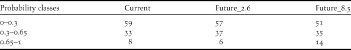

Figure 3. Models of habitat suitability for the species based on the present climatic data (A) and CCSM2.6 (B) and CCSM8.5 (C) for the future.
Discussion
The distribution map that we developed for the Houbara in Iran is in concordance with previous knowledge on the species’ distribution (Mansoori and Kiabi Reference Mansoori and Kiabi2003, Mansoori Reference Mansouri2006). We found annual precipitation to be the most important predictor of Houbara presence, possibly due to its effect on vegetation conditions and productivity of the arid habitats occupied by this species (Mian Reference Mian2003, Carrascal et al. Reference Carrascal, Palomino, Seoane and Alonso2008). Precipitation in desert and semi-desert areas of Iran varies from zero in Dasht-e Lut and Dasht-e Kavir in central Iran, to 160–170 mm at the edges of deserts and semi-deserts. With increasing precipitation, suitability increases for this species and reaches a maximum in areas that receive around 170 mm of annual precipitation. However, as precipitation exceeds this threshold, landscape type also changes, mostly becoming highly elevated and with steep slopes, which are not suitable for the Houbara.
Topography is another major predictor of regional distribution of avifauna in arid environments (Kaboli et al. Reference Kaboli, Guillaumet and Prodon2006). Steppe birds occupy habitats with a level relief and structural simplicity (de Juana Reference de Juana, Bota, Morales, Mañosa and Camprodon2005). Although we initially expected topography, particularly slope, to be the most important variable, our results indicate that slope is the second most important limiting factor for the wintering population of the Houbara and that suitability is reduced in regions with slopes > 10%. Consequently, major mountainous areas in the country fall into the range of unsuitable habitats in our model.
Previous studies on the wintering populations of the Houbara indicate that the birds regularly visit croplands to feed (Aghainajafi-Zadeh et al. Reference Aghainajafi-Zadeh, Hemami, Karami and Dolman2010). Our results are in concordance with these findings, as vicinity to cropland was the next most important variable in determining habitat suitability for the Houbara. With an increase in habitat loss, farmlands provide the most similar habitats to the homogenous open terrain that steppe birds naturally occupy (de Juana Reference de Juana, Bota, Morales, Mañosa and Camprodon2005). Croplands and farmlands have therefore commonly been reported as an important habitat requirements of bustard species (Lane et al. Reference Lane, Alonso and Martín2001, Osborne et al. Reference Osborne, Alonso and Bryant2001, Gray et al. Reference Gray, Chamnan, Borey, Collar and Dolman2007, Suárez-Seoane et al. Reference Suárez-Seoane, García de la Morena, Morales Prieto, Osborne and de Juana2008). For instance, in landscapes comprising natural steppes interspersed with agricultural patches, Little Bustards Tetrax tetrax are likely to shift their habitats closer to agricultural land and use them in addition to, or in compensation for, the resources that the natural habitat provides (Wolff Reference Wolff, Bota, Morales, Mañosa and Camprodon2005). There is a downside to the attractiveness of croplands for the Houbara, however, since these human-dominated areas might become ecological traps (Battin Reference Battin2004), leading the Houbara to high-risk areas where hunting is a threat.
We investigated the effect of human disturbance on habitat suitability of Houbara by including two related variables (distance to human settlements and distance to roads) in the models. However, these variables did not prove to be critical. This finding might seem inconsistent with the previous finding about vicinity to agricultural land and it might be argued that agriculture is a form of human disturbance. However, by considering the agricultural landscape in arid and semi-arid areas of Iran, where such land uses are often located at considerable distances from villages and accessible by dirt roads, a distinction can be made between these variables.
Projecting the Houbara climate-only model to future climatic conditions showed an increase in the overall area of suitable habitat in Iran. However, considerable shifts in the geographic distribution of suitable habitats were also observed, which will mean that birds occupying different parts of the country will be affected differently, as previously suitable habitats lose their suitability and previously unoccupied habitats will become suitable. Particularly, southward and eastward shifts of climatically suitable habitats into Dasht-e Kavir and into Dasht-e Lut, respectively, are expected. Both Dasht-e Lut (area of about 51,800 km2) and Dasht-e Kavir (about 77,600 km2) are deserts with currently unsuitable habitat for the Houbara due to very limited, almost non-existent, rainfall. Whether birds occupying different regions in Iran will be able to respond to these shifts remains unknown, indicating that these potential shifts in suitable habitats can be considered as potential threats to this species in Iran.
The suitable areas that our model identified, particularly in areas that are expected to remain suitable under climate change, are ideal choices for concentrating conservation efforts for habitat management and monitoring of wintering populations of the Houbara. Overgrazing and hunting, the two main threats to the Houbara in Iran, also need to be controlled more effectively in such areas to make them more effective in conservation of the wintering population and also prepare them to be potential release sites for individuals bred in captivity (Heydari et al. Reference Heydari, Hemami and Aghainajafi-Zadeh2010) in order to rehabilitate the declining populations of Houbara (BirdLife International 2014). Further investigations into the distribution and characteristics of breeding habitats for the Houbara in Iran are necessary in order to investigate protected area effectiveness and to ensure that seasonal needs of this species (Heezik and Seddon Reference Heezik and Seddon1999) are met in Iran.
Supplementary Material
To view supplementary material for this article, please visit https://doi.org/10.1017/S0959270916000381
Acknowledgements
We thank the following colleagues for providing distribution data on the Asian Houbara Bustard: Hossein Abbasian of Yazd provincial office; and Leila Jolaii of Fars provincial office.


