Introduction
Last century, over half of the wetlands around the world were lost (Kar Reference Kar2013, Chen et al. Reference Chen, Dong, Xiao, Zhang, Tian, Zhou, Li and Ma2016), causing dramatic declines in wetland-dependent waterbird populations (Butchart et al. Reference Butchart, Walpole, Collen, Van Strien, Scharlemann, Almond, Baillie, Bomhard, Brown and Bruno2010, Wang et al. Reference Wang, Fraser and Chen2016). The remaining natural wetlands are undergoing extensive degradation, reducing their carrying capacity and adversely affecting the remaining waterbirds (Butchart et al. Reference Butchart, Walpole, Collen, Van Strien, Scharlemann, Almond, Baillie, Bomhard, Brown and Bruno2010, Hua et al. Reference Hua, Tan, Chen and Ma2015). Provision of essential habitats for waterbirds through effective management of wetlands in these changing environments is a critical issue in waterbird conservation (Ma et al. Reference Ma, Cai, Li and Chen2010, Gardner and Davidson Reference Gardner, Davidson and LePage2011, Zhang et al. Reference Zhang, Wang, Zhang, Ouyang, Chan, Crosby, Watkins, Martinez, Su and Yu2017).
Habitat availability for waterbirds in seasonally recessional wetlands is highly dependent on the water level regime (Holm and Clausen Reference Holm and Clausen2006, Baschuk et al. Reference Baschuk, Koper, Wrubleski and Goldsborough2012). The relationship between water level and habitat availability differentially affects waterbirds with different morphologies that occupy ecological niches at different water depths (Darnell and Smith Reference Darnell and Smith2004, Mei et al. Reference Mei, Dai, Du and Chen2015). For instance, geese generally use exposed riparian grassland as foraging habitats, while shorebirds and waders forage in mudflats and shallow water. Swimming birds feed in deeper water and diving birds forage at water depths that require them to dive (Robertson and Massenbauer Reference Robertson, Massenbauer, Zerger and Argent2005). The spatial heterogeneity of wetland topography creates diverse habitats with different water depths that support a high species richness of waterbirds (Ntiamoa-Baidu et al. Reference Ntiamoa-Baidu, Piersma, Wiersma, Poot, Battley and Gordon1998, Ma et al. Reference Ma, Cai, Li and Chen2010). Water level also fluctuates with seasonal flooding, resulting in temporal heterogeneity in water depth. This drives temporal changes in habitat availability and accessibility for waterbirds with varying effects among different guilds (Bolduc and Afton Reference Bolduc and Afton2004, Cumming et al. Reference Cumming, Paxton, King and Beuster2012). Therefore, understanding how water level fluctuation regulates habitat availability for different waterbird guilds is crucial for the conservation of waterbirds in dynamic systems (Bolduc and Afton Reference Bolduc and Afton2004, Jiang et al. Reference Jiang, Qi, Liao, Ding and Wang2014).
The seasonally recessional lacustrine wetlands in the middle and lower Yangtze River floodplain provide important staging and wintering habitats for more than one million waterbirds of over 100 species that migrate thousands of kilometres along the East Asian-Australasian Flyway (Fang et al. Reference Fang, Wang, Zhao, Li, Tang, Yu, Ni, Liu, Xie and Da2006, Wang et al. Reference Wang, Fraser and Chen2016). The wintering waterbird assemblages are highly associated with the seasonal water level fluctuations in the Yangtze River-connected lakes (Wang et al. Reference Wang, Jia, Guan, Lu, Lei, Wen and Liu2013, Jiang et al. Reference Jiang, Qi, Liao, Ding and Wang2014). During the winter dry season, low water level exposes large areas of submerged ground and enables waterbirds to find food (Wang et al. Reference Wang, Jia, Guan, Lu, Lei, Wen and Liu2013, Jia et al. Reference Jia, Koyama, Choi, Kim, Cao, Gao, Liu and Fox2016). However, over the past 40 years, the natural habitats in this region have become severely degraded through a combination of wetland reclamation, aquaculture, and damming of the Yangtze River (Fang et al. Reference Fang, Rao and Zhao2005, Chen et al. Reference Chen, Dong, Xiao, Zhang, Tian, Zhou, Li and Ma2016, Yu et al. Reference Yu, Wang, Cao, Zhang, Jia, Lee, Xu, Liu, Xu and Hu2017). Shengjin Lake, a newly designated Wetland of International Importance, provides wintering grounds for 5–10% of the total waterbirds in the Yangtze floodplain corridor, and is also affected by these threats (Fox et al. Reference Fox, Cao, Zhang, Barter, Zhao, Meng and Wang2011, Jia et al. Reference Jia, Koyama, Choi, Kim, Cao, Gao, Liu and Fox2016). Degradation of the natural wetland habitats has changed the foraging grounds and dramatically reduced populations of many wintering waterbird species at the lake (Cheng et al. Reference Cheng, Cao, Barter, Xu, Zhang and Zhao2009, Zhang et al. Reference Zhang, Jia, Prins, Cao and de Boer2015). Among the threats, water level control for aquaculture has changed the natural hydrological regime, desynchronising the exposure of habitats and the arrival of the wintering waterbirds (Fox et al. Reference Fox, Cao, Zhang, Barter, Zhao, Meng and Wang2011, Zhao et al. Reference Zhao, Cong, Barter, Fox and Cao2012). Therefore, conservation research should focus on the management of water level and its effects on the habitats of the wintering waterbirds.
In this study, we aimed to understand how seasonal water level fluctuations regulate habitat availability for the wintering waterbirds at Shengjin Lake. First, we conducted population surveys of wintering waterbirds, and categorised them into four groups based on their dominant foraging habitats observed in the field. Second, we produced habitat maps and quantified habitat availabilities for the waterbirds at different water levels by classifying Landsat TM/ETM images. Based on the results, we suggest optimal management plans to control the water level to facilitate waterbird conservation at Shengjin Lake and the other lacustrine wetlands with similar seasonal flooding in the Yangtze River floodplain.
Methods
Study area
Shengjin Lake (30°15’–30°30’ N, 116°55’–117°15’ E) is located on the south bank of the lower reaches of the Yangtze River. It has a subtropical monsoon climate, with an average annual precipitation of 1,600 mm, with the majority falling between March and August. The mean water level of the lake is 8.9 m in winter and 12.5 m in summer, when the water surface reaches up to 14,500 ha at the peak flood. The shape of the lake basin and direction of water flow divides the lake into three parts, namely the Upper Lake, the Central Lake, and the Lower Lake (Figure 1). The lake collects water from an area of 154,810 ha via surface runoff and rivers. The two main tributaries, the Zhangxi River and Tangtian River, run into the Upper and Central Lakes, respectively. Water exchange between Shengjin Lake and the Yangtze River is controlled by the Huangpen Sluice Gate located in the Huangpen River in the Lower Lake.

Figure 1. The study area and counting points for waterbird field surveys at Shengjin Lake.
The aquatic vegetation shows zonal distribution in accordance with water depth in the lake and can be divided into submerged, floating, emerged, and swamp communities. The primary components of the submerged community are mainly curled pondweed Potamogeton crispus, Eurasian watermilfoil Myriophyllum spicatum, and pondweed P. distinctus. Floating communities are mainly composed of water chestnut Trapa bispinosa and little fox nut Euryale ferox. Common reed Phragmites australis, water pepper Polygonum hydropiper, and Manchurian wild rice Zizania latifolia sporadically appear in the shallow water forming the emerged community. Swamp communities are dominated by sedges Carex spp. and carpet cinquefoil Potentilla supina (Ma Reference Ma2011).
Population surveys from 2004 to 2009 revealed that each winter Shengjin Lake provides habitats for up to 70,000 waterbirds of over 80 species dominated by Anatidae that accounts for 86% of the entire waterbird community (Cao et al. Reference Cao, Barter, Zhao, Meng and Zhang2011a). Several species, which are globally threatened or have internationally important numbers (> 1% of their flyway population), were also recorded, e.g. Siberian Crane Leucogeranus leucogeranus, Hooded Crane Grus monacha, White-naped Crane Antigone vipio, Black Stork Ciconia nigra, Oriental White Stork C. boyciana, Eurasian Spoonbill Platalea leucorodia, Swan Goose Anser cygnoid, Lesser White-fronted Goose A. erythropus, Greater White-fronted Goose A. albifrons, Bean Goose A. fabalis, Tundra Swan Cygnus columbianus, Baikal Teal Sibirionetta formosa, and Falcated Duck Mareca falcata (Barter et al. Reference Barter, Chen, Cao and Lei2004, Reference Barter, Lei and Cao2006, Cao et al. Reference Cao, Barter, Zhao, Meng and Zhang2011a). In order to protect the wintering waterbirds and their habitats, Shengjin Lake Nature Reserve was established in 1986 and upgraded to national status in 1997. The total reserve covers 33,340 ha and the core zone encompasses the largest flooded area. The lake was adjoined to the Northeast Asia Crane Network Protection Zone in 2002 and the East Asian-Australasian Birds Migration Network in 2010, and has also been identified as an Important Bird Area by BirdLife International (BirdLife International 2004).
Waterbird surveys
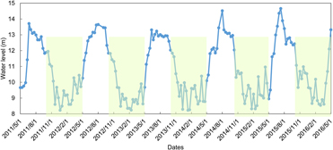
We divided the wintering season for waterbirds at Shengjin Lake into three periods, i.e. early (October–December), middle (January–February), and late (March–April) (Figure 2) based on the seasonal water level fluctuation and migration phenology of the waterbirds. To identify the main habitat types used by different waterbird species and their spatial distribution during different wintering periods, we conducted three surveys at Shengjin Lake on 2 March 2014, 2 November 2014, and 12 January 2015. We followed the taxonomy of BirdLife International (2016) and defined waterbirds as species of birds that are “ecologically dependent upon wetlands” according to the Ramsar Convention (Gardner and Davidson Reference Gardner, Davidson and LePage2011). We followed the methods used by Barter et al. (Reference Barter, Chen, Cao and Lei2004, Reference Barter, Lei and Cao2006) to conduct the field surveys. Specifically, we observed waterbirds along the shoreline at 20 representative points that covered nearly the same observation areas as Barter et al. (Reference Barter, Chen, Cao and Lei2004, Reference Barter, Lei and Cao2006) (Figure 1). Distances between any two observation points were greater than 2 km to avoid double counting. Four teams of two skilled bird observers conducted the surveys simultaneously using the “look-see” counting method on sunny days without strong wind or heavy fog (Delany Reference Delany2005). Waterbirds within a radius of approximately 1 km of each point were recorded for about 20 min using binoculars (10 × 42 WB Swarovski) and a telescope (20–60× zoom Swarovski: ATM 80). Species name, location, flock size, foraging habitats, and behaviour of the waterbirds were recorded. Flying birds, except those flushed from within the observation area, were not recorded.

Figure 2. Seasonal water level fluctuations during the past five years (2011–2016) at Shengjin Lake. The green shaded area indicates the period of wintering season defined in the study.
Waterbirds were categorised into four groups based on the field observations of their dominant foraging habitats: geese, shorebirds, larger waders, and deep-water feeders. We used “shorebirds” to refer to members of the order Charadriiformes, while waders included long-legged wading birds, such as storks, cranes, herons, and egrets. Deep-water feeders included swimming and diving birds. Geese, shorebirds, larger waders, and deep-water feeders primarily foraged on riparian grassland, mudflats, shallow water, and deep water, respectively (Robertson and Massenbauer Reference Robertson, Massenbauer, Zerger and Argent2005, Ma et al. Reference Ma, Cai, Li and Chen2010). It should be noted that the three surveys each represented only a short period of the wintering season, so we could not statistically determine the relationship between water level dynamics and habitat use or population trends of the wintering waterbirds at Shengjin Lake. Therefore, we focused on how the seasonal water level fluctuation affected availability of the four habitat types for wintering waterbirds, rather than their habitat use or population trends during winter.
Landsat image classifications and accuracy assessments
We downloaded Level 1T Landsat TM/ETM images (path 121/row 39) with little or no cloud cover for the study area (Table S1 in the online Supplementary Material) from the USGS website (http://glovis.usgs.gov/). The 16 images used for land-cover classifications were acquired during the same periods as the waterbird surveys. We used the image acquired on 18 August 2010, when the water level (14.56 m) was the highest during the last decade, to delineate the boundary of the study area. All the images had been radiometrically and geometrically (systematically) corrected by the Landsat sensors using observatory ephemeris data and ground control points (NASA Landsat Program 2002, 2003). They were reprojected onto the UTM WGS 1984 N50 coordinate system and resampled to 30 m using the nearest neighbour method. We obtained water level data (the reference level zero was the local Wu Song datum) measured inside the Huangpen Sluice Gate during the last five years from the Anhui Water Resource Commission. The water levels measured on the same days as the image acquisitions showed a gradient with an average interval of 0.40 ± 0.07 m.
Following Walsh et al. (Reference Walsh, Crawford, Welsh and Crews-Meyer2001) and Bortels et al. (Reference Bortels, Chan, Merken and Koedam2011), a hybrid unsupervised-supervised method was used to classify images in ENVI 5.1 (Exelis VIS Inc.). First, 30 “naturally” occurring spectral clusters were generated using an unsupervised classification method of the Iterative Self-Organizing Data Analysis Technique (ISODATA), which assigns pixels of the images to spectrally distinct clusters according to their spectral distance. Then, land-cover types were assigned to each of the spectral clusters through visual interpretation of the common false color composites. Finally, a supervised classification was conducted using the maximum likelihood classifier (MLC) and the 30 clusters were used as the training set. Based on the analyses of habitat types for the four waterbird groups observed in the field, four land-cover classes were recoded from the 30 clusters: deep water, shallow water, mudflats, and grassland. These four classes were visually interpreted in optimal RGB combinations of the Landsat image bands. In the near-infrared and mid-infrared regions, water increasingly absorbs the light making it darker on the image depending on water depth and wavelength. The combination of near-infrared, mid-infrared, and red bands demonstrates moisture differences, thus, offering a distinct definition of mudflat-water boundaries. Deep water is very dark and shallow water appears as shades of lighter blue in combinations of near-infrared, shortwave infrared, and blue. Grassland appears in shades of light-red in combinations of near-infrared, red, and green. Floating or submerged vegetation were not extracted from the satellite images.
We conducted an accuracy assessment only on the classified image from 25 March 2015. During the same week, the water level did not change significantly and we collected 200 ground truth points that were evenly distributed in the four land-cover classes. A standard error matrix was constructed, and overall, user, and producer accuracies and kappa coefficients were calculated (Congalton and Green Reference Congalton and Green2008). The remaining images were classified using the same procedures, but the accuracy was not assessed due to lack of homochromous ground truth samplings.
Based on the land-cover maps, we calculated Shannon’s diversity index (SHDI) and Shannon’s evenness index (SHEI), using Fragstats v. 4.2 (Kupfer Reference Kupfer2012, McGarigal et al. Reference McGarigal, Cushman and Ene2012), to quantify the habitat heterogeneity for different water levels at the landscape scale. For each image, we also used the following formula to calculate an NDVI map, which has been shown to be positively correlated with grass biomass (Klemas Reference Klemas2013, Fuller and Wang Reference Fuller and Wang2014). Mean and total NDVI values were calculated for the pixels that were classified as grassland.
 $${\rm{NDVI}} = \left( {{\rm{NIR}}\,{\rm{ - }}\,{\rm{R}}} \right)/\left( {{\rm{NIR}} + {\rm{R}}} \right)$$
where, NIR is the near infrared reflectance, and R is the red reflectance of the Landsat images.
Data analysis
Linear regressions were used to investigate how potential habitat areas (ha) for each waterbird group, mean NDVI, total NDVI (log10-transformed), SHDI, and SHEI (response variables) changed with the fluctuation in water level (m) (explanatory variable). Prior to statistical analysis, residuals of the response variables were tested for normality using the Shapiro-Wilk Test. The total NDVI was log10-transformed to meet the assumptions of normality. Residuals of the other response variables were normally distributed (P > 0.05). All statistical analyses were conducted in R 3.3.1 and the significance level was set at P < 0.05.
Results
Land-cover and accuracy assessments
The overall accuracy was 92.5% and the kappa coefficient was 0.90, indicating high image classification accuracy. User and producer accuracies for the four kinds of land-cover classes were all above 88%. The standard error matrix revealed few overlaps in classification between land-covers (Table 1).
Table 1. Error matrix and accuracy assessment for the classification of Landsat images acquired on 25 March 2015 for mapping the land-covers at Shengjin Lake.

The land-cover configuration at Shengjin Lake was significantly affected by water level, which began to rise in April and peaked in August when the entire lake basin was submerged (14,500 ha) (Figure 2). From late September, the water began to recede and the grassland and mudflat habitats were gradually exposed. The water area decreased to 7,474 ha when the water level fell to its lowest point (8.21 m). The lakebed was exposed first and large areas of riparian habitats, e.g. grassland and mudflats, occurred in the Upper and Lower Lakes at the lowest water level. There were fewer exposed habitats, especially grassland, in the Central Lake, which was dominated by deep water throughout the entire wintering period (Figure 3 and S1).

Figure 3. Land-cover maps of six representative water levels at Shengjin Lake. Land-cover maps for other water levels are displayed in supplementary Figure S1.
Waterbird communities
We recorded a total of 52 waterbird species (Table 2 and Table S2). Geese were the dominant group throughout the entire wintering season, accounting for more than 80% of the total number of waterbirds during the early and late wintering periods, and 67.4% during the middle period. Deep-water feeders were the second most abundant and peaked in the middle wintering period at 24.2%. Large waders and shorebirds accounted for less than 6.0% and 3.5%, respectively, during the entire wintering season. There were nine species classified as threatened or near threatened on the IUCN Red List, Oriental White Stork, Hooded Crane, Swan Goose, Lesser White-fronted Goose, Eurasian Curlew Numenius arquata, White-naped Crane, Dalmatian Pelican Pelecanus crispus, Black-tailed Godwit Limosa limosa, and Falcated Duck. There were nine species that exceeded 1% of the East Asian-Australasian flyway population: Bean Goose, Greater White-fronted Goose, Great Cormorant Phalacrocorax carbo, Falcated Duck, Lesser White-fronted Goose, Eurasian Spoonbill, Hooded Crane, Oriental White Stork, and Dalmatian Pelican.
Table 2. Waterbirds recorded in different habitat types at Shengjin Lake during the three surveys conducted on 2 March 2014, 2 November 2014, and 12 January 2015 (EN-Endangered, VU-Vulnerable, NT-Near Threatened, INT.IMP-Internationally Important).

1 Dominant groups foraging in each habitat type were those that had the most individuals.
2 Dominant species were the first and second most abundant species in each habitat type.
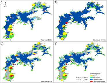
The spatial distribution of waterbirds at Shengjin Lake followed the spatial patterns of available habitats (Figure 4). During the wintering period, the vast tracts of mudflats and grassland in the Upper Lake attracted more than 21,000 wintering waterbirds. Among this community, there were nearly 17,000 geese and 3,600 swimming and diving waterbirds. We also observed populations of six threatened or near threatened species in this area. The Lower Lake provided the second most suitable foraging habitats for wintering waterbirds. More than 5,200 geese and more than 600 large waders were observed in this area. However, less than 2,500 waterbirds were observed in the Central Lake, where deep water dominated during the entire wintering period.

Figure 4. Spatial distribution of different groups of waterbirds at Shengjin Lake on a) 2 March 2014, b) 2 November 2014, and c) 12 January 2015. The underlying land-cover maps were interpreted from images acquired on 22 March 2014, 17 November 2014, and 13 February 2015, which were close to the survey dates. The mean bird abundance at each survey point during the three surveys is displayed in panel d) with the lowest water level (8.21 m). Bird abundance at each site is represented by the size of the pie chart and is also displayed to the right of each pie.
Habitats for different waterbird groups
Nearly 80% of all recorded birds occurred in riparian grassland, of which over 99.7% were geese. Shorebirds mainly foraged in the mudflats and represented 81.5% of the waterbird communities there. Shallow water was dominated by large waders, especially herons and egrets, which constituted 85.5% of the community. The dominant species in deep water were Great Cormorant (37.0%), Black-headed Gull Larus ridibundus (18.8%), and ducks (36.5%).
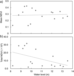
Linear regression showed that areas of shallow water, grassland, and mudflats were negatively correlated with the water level, while the deep-water area was positively correlated with the water level (Table 3 and Figure 5). The deep-water area was the dominant land-cover during the whole wintering period, with an area of at least 6,200 ha (43.3% of the total lake area), providing habitat for deep-water feeders. There were approximately 360 ha of shallow water, 520 ha of mudflats, and 1,080 ha of grassland during the early wintering period when the water level was about 12 m. As the water level continued to recede during the wintering period, mudflats and grassland were increasingly exposed, providing habitats for waders, shorebirds, and geese. In the middle wintering period, when the water level fell to its lowest point (8.21 m), approximately 1,270 ha of shallow water (8.9%), 4,280 ha of mudflats (29.9%), and 2,560 ha of grassland (17.9%) were available on the lakebed (Figure 3 and 5). Meanwhile, diversity and evenness indexes of the habitat types increased with the receding water level (Table 3 and Figure 5). We did not find any significant effects of water level on the mean or total NDVI (Table 3 and Figure 6).
Table 3. Linear regressions between water level and habitat variables at Shengjin Lake.


Figure 5. Relationship between water level (the reference level zero was the local Wu Song datum) and a) potential habitat areas for different groups of waterbirds, and b) diversity and evenness of habitat types at Shengjin Lake.

Figure 6. Relationship between water level (the reference level zero was the local Wu Song datum) and a) mean NDVI, and b) total NDVI calculated for the image pixels (30 m × 30 m) that were classified as grassland at Shengjin Lake.
Discussion
Habitat availability for wintering waterbirds at Shengjin Lake was significantly correlated with fluctuations in water level. The lake bed was submerged beneath deep water during the summer flooding season. From late September, water began to recede and a diversity of riparian habitats was gradually exposed, providing foraging grounds for a large number of waterbirds in different foraging guilds (Robertson and Massenbauer Reference Robertson, Massenbauer, Zerger and Argent2005, Holm and Clausen Reference Holm and Clausen2006). As one of the important migration sites along the East Asian-Australasian Flyway, wintering waterbirds arrive at Shengjin Lake in late September and large numbers begin to aggregate at the lake from October each year (Barter et al. Reference Barter, Chen, Cao and Lei2004, Reference Barter, Lei and Cao2006). However, the water level over the last decade has been kept constant for aquaculture by the Huangpen Sluice Gate, and it was still high (> 12 m) during the early wintering period (Cheng et al. Reference Cheng, Cao, Barter, Xu, Zhang and Zhao2009, Cao et al. Reference Cao, Barter, Zhao, Meng and Zhang2011a). Therefore, most of the riparian habitats were submerged and were not available to the early-arriving waterbirds, especially shorebirds and waders. This caused the arriving birds to move to other regions or the surrounding artificial wetlands where there are many anthropogenic disturbances (Fox et al. Reference Fox, Cao, Zhang, Barter, Zhao, Meng and Wang2011, Li et al. Reference Li, Zhou, Xu, Zhao and Beauchamp2015, Yu et al. Reference Yu, Wang, Cao, Zhang, Jia, Lee, Xu, Liu, Xu and Hu2017). Compared to the survey in the winter of 2004–2005, which covered nearly the same areas of the lake, we recorded nearly 19% fewer waterbird individuals (about 9,000) (Barter et al. Reference Barter, Lei and Cao2006). The artificial change in cyclic hydrology may be one of the important reasons for the decline. The negative effects of inappropriate artificial control of water level on waterbird communities have been observed in other regions (Wang Reference Wang2008, Mei et al. Reference Mei, Dai, Du and Chen2015).
The spatial distribution of the wintering waterbirds was largely correlated with the land-cover patterns at Shengjin Lake, as has been found in wetlands worldwide (Wang Reference Wang2008, Baschuk et al. Reference Baschuk, Koper, Wrubleski and Goldsborough2012, Gul et al. Reference Gul, Onmus and Siki2013). The lakebed of the Upper Lake was exposed first and for a longer duration due to its relatively higher elevation. Meanwhile, the gentle slope created by sediment deposition and nutrients from the Zhangxi River in the southern drainage basin promoted the growth of recessional sedges (Ma Reference Ma2011, Kolada Reference Kolada2014). Therefore, a large population of herbivorous birds, especially geese (>17,000), gathered here to feed during the flood recession period (Cheng et al. Reference Cheng, Cao, Barter, Xu, Zhang and Zhao2009, Cao et al. Reference Cao, Barter, Zhao, Meng and Zhang2011a, Zhao et al. Reference Zhao, Cong, Barter, Fox and Cao2012). Aquatic invertebrates in the mudflats and shallow water also attracted shorebirds, despite the small number of shorebirds in the entire lake. In the Lower Lake, the habitat was less suitable and waterbirds were less abundant. Aquaculture was most intense in the Central Lake, resulting in a nearly-bare lakebed, and a habitat of very poor quality for the wintering waterbirds (Cao et al. Reference Cao, Meng, Yang, Shan, Liu and Fox2011b, Fox et al. Reference Fox, Cao, Zhang, Barter, Zhao, Meng and Wang2011). Although deep water was the dominant habitat in the entire lake throughout the year, deep-water feeders were less abundant than geese. This may be attributed to lack of food for the deep-water feeders due to wetland degradation.
Mudflats are considered one of the optimal habitats for shorebirds and cranes that probe for aquatic invertebrates and tubers of submerged macrophytes (Isola et al. Reference Isola, Colwell, Taft and Safran2000, Fox et al. Reference Fox, Cao, Zhang, Barter, Zhao, Meng and Wang2011, Jia et al. Reference Jia, Jiao, Zhang, Zhou, Lei and Liu2013). The impact of water level on mudflats was interesting in that this habitat area was small and increased slowly before the water level fell to about 9 m, but then more rapidly during the last drying period (from 9.19 m to the lowest point) (Figures 3 and 5). This trend is important because it suggests there would not be enough foraging habitat for early-arriving shorebirds and the moist mudflats would quickly become dry after the sudden late exposure. Furthermore, the dominant submerged macrophyte and aquatic invertebrate communities in the lake had been destroyed by intensive aquaculture (Fang et al. Reference Fang, Wang, Zhao, Li, Tang, Yu, Ni, Liu, Xie and Da2006, Cao and Fox Reference Cao and Fox2009, Ma Reference Ma2011). The collapse of this food resource caused a decrease in birds foraging in the mudflats (Table 2), despite the large area available during the end of the drying period.
Although habitat diversity increased as the water level receded, we do not suggest that dry conditions would be more suitable for wintering waterbirds. Severe drought could initiate succession from wetland to upland habitat, which does not favour wintering waterbirds (Klein et al. Reference Klein, Berg and Dial2005). Effective management should allow the water level to recede gradually, rather than rapidly, to provide a continuous supply of newly exposed habitats over a longer period (Zhang et al. Reference Zhang, Jia, Prins, Cao and de Boer2015). A detailed stepwise water recession plan should be formulated, according to the migration phenology of the waterbirds wintering in Shengjin Lake, to provide essential habitats for the birds arriving at different times. In particular, water level during the early wintering period should be lower to provide more habitats for the early-arriving birds. More importantly, the exposed habitats should be abundant in food for the waterbirds (Kupfer Reference Kupfer2012, Pap et al. Reference Pap, Nagy, Balogh, László and Liker2013). Therefore, management of the water level should not be independent but combined with the recovery of the aquatic vegetation and invertebrate communities (Fang et al. Reference Fang, Wang, Zhao, Li, Tang, Yu, Ni, Liu, Xie and Da2006, Cao and Fox Reference Cao and Fox2009, Zhang et al. Reference Zhang, Jia, Prins, Cao and de Boer2015). Meanwhile, high-density aquaculture should be reduced to sustainable yields, to protect submerged macrophytes and reduce human disturbances from fishing during the wintering season. To this end, inter-sectoral collaboration and cooperation should be established to achieve integrated management of the lake. Specifically, Government should create an inter-sectoral coordination committee comprised of experts and departments that oversee water resources, forestry, land use, fishery resources, and environment protection. These departments should jointly manage the basin to achieve basin-level action, such as water allocation, dam operation, pollution control, and land use planning. Through this joint management, wetland biodiversity conservation and sustainable use could become mainstream in this region.
Loss and degradation of wetlands is ongoing worldwide and negatively affects the survival of wetland-dependent waterbirds (Butchart et al. Reference Butchart, Dieme-Amting, Gitay, Raaymakers and Taylor2005, Reference Butchart, Walpole, Collen, Van Strien, Scharlemann, Almond, Baillie, Bomhard, Brown and Bruno2010, Kirby et al. Reference Kirby, Stattersfield, Butchart, Evans, Grimmett, Jones, O’Sullivan, Tucker and Newton2008). Conservation and management communities have realized the importance of Shengjin Lake in providing essential stop-over and wintering habitats for tens of thousands of waterbirds along the East Asian-Australasian Flyway (Cao and Fox Reference Cao and Fox2009, Hua et al. Reference Hua, Tan, Chen and Ma2015, Zhang et al. Reference Zhang, Wang, Zhang, Ouyang, Chan, Crosby, Watkins, Martinez, Su and Yu2017). However, degradation of the natural wetland continues and there are no effective conservation plans in preparation. The relationship between water level and habitat availability has important implications and should guide the conservation and management of wintering waterbirds and habitats in this lake. Our findings may also inspire more effective management of other lacustrine wetlands with similar hydrology regimes in the Yangtze River floodplain.
Supplementary Material
To view supplementary material for this article, please visit https://doi.org/10.1017/S0959270918000035
Acknowledgements
We appreciate the support from Shengjin Lake National Nature Reserve Management Center. We are grateful to Song Yunwei, Li Bo, Wan Wenjing, and Zhao Guanghong for their field assistance. We thank Guy Beauchamp from University of Montréal in Canada and Editage [www.editage.cn] for English language editing. We also acknowledge the provision of free access to Landsat imagery from the U.S. Geological Survey. The study was supported by the National Natural Science Foundation of China (C.L., grant numbers 31770571 and 31301897), (L.Z., grant number 31472020); the Ph.D. Programs Foundation of the Ministry of Education of China (C.L., grant number 20133401120014); the Natural Science Foundation of Anhui Province (C.L., grant number 1308085QC64); and the Natural Sciences Foundation of Education Department of Anhui Province (C.L., grant number KJ2013A023).