


Introduction
Between 1858 and 1866, the Western submarine telegraph cable community was troubled by uncertainty. In 1858, after considerable investments and difficult transnational collaboration between Britain and The United States, the first transatlantic submarine cable had been inaugurated with great fanfare, but the triumph lasted only three weeks. After increasing deprecation of the cable and an exponential decrease in transfer speed, it stopped working, and the cable, as well as all funds invested in laying it, was lost to the Atlantic Ocean.
The failure of the first transatlantic submarine telegraph cable resulted in disappointment and disillusion, but also a good amount of hesitation about the idea of connecting Europe and North America through an undersea telegraph cable across the Atlantic (Shaffner, Reference Shaffner1859). Significantly, this interruption in the efforts to connect London and New York as Western centres of trade also created an opportunity to reconsider what were possible and sensible approaches to cable telegraphy.
In this study, I aim to shed new light on the cultural history of Arctic infrastructures, particularly those of Greenland, whose territory made up the most controversial section of a proposed alternative telegraph route. In 1860, the Faroe Islands, Iceland as well as most of Greenland were under Danish rule, while Norwegian claims challenged Danish sovereignty over East Greenland. Following the sale of the West Indies to The United States in 1917, Danish sovereignty over Greenland was gradually acknowledged. Danish colonial rule in Greenland was constant until WW2, where contact between Denmark and Greenland was severed, and the United States established military bases and defence systems in Greenland, followed by an intense post-war Danish modernisation process in the 1950s and 1960s. Several studies have charted the critical role played by Denmark and The United States in the planning and construction of Greenlandic infrastructures such as airports, military bases and settlements (Hemmersam, Reference Hemmersam2021; Nielsen, Reference Nielsen, Brook, Dodge and Hogg2020). However, I want to draw attention to “The Northern Route,” a set of understudied plans in the 19th century for a telegraph cable connecting Europe and Northern America, which would have made Greenland, Iceland and the Faroe Islands essential hubs in transatlantic communication in the 1860s.
In the historical literature on the large Arctic infrastructural projects that transverse the Kingdom of Denmark, the planning and construction of communication infrastructures has received limited scholarly attention. Among the few exceptions are histories of telecommunication companies such as GN Store Nord (Jacobsen, Reference Jacobsen2019) a Danish-language publication on the history of technology in Greenland (Steenfos & Taagholt, Reference Steenfos and Taagholt2012), as well as communication infrastructures that are perceived as relevant in a security or military context, such as hyperbolic radio navigation systems (Jákobsstovu & Berg, Reference Jákobsstovu and Berg2012) and weather stations (Dunbar, Reference Dunbar1950). The dominant literature on the region’s infrastructural history are studies of resource extraction and military projects such as Project Iceworm and Camp Century (see for instance Nielsen & Nielsen, Reference Nielsen, Nielsen, Doel, Harper and Heymann2016; Nielsen, Reference Nielsen, Brook, Dodge and Hogg2020; Nielsen, Nielsen, & Martin-Nielsen, Reference Nielsen, Nielsen and Martin-Nielsen2014; Petersen, Reference Petersen2008). While resource extraction and military installations are easily read as gauges for shifting global politics, civilian and commercial technologies of communication and their infrastructures have not been studied as crucial markers of the region’s history.
Scholarly interest in Greenland’s infrastructure has principally focused on the period during and following WWII, in particular the cold war-era, where Greenland was “a platform and as an extended arm within [US] security and foreign policy” (Ackrén & Jakobsen, Reference Ackrén and Jakobsen2015, p. 1). In contrast, the 19th century is mostly absent as a period where significant transatlantic infrastructural development took place in the Arctic territories of the Kingdom of Denmark.
The same cannot be said for history of technology scholars working on cable telegraphy, who have studied the period (1858–1866) and broader region (the North Atlantic) in focus here in detail, as the period overlaps with the first establishments of telegraph cable networks between 1850 and 1880 (Starosielski, Reference Starosielski2015). However, our interest here is not the eventually successful Great Atlantic Cable, a “main protagonist” of the North Atlantic Telegraphic stage, nor cable telegraphy’s hugely influential “class of 1866” (Müller, Reference Müller2010), but rather the significance of ostensibly dead-end projects and overlooked actors such as The Northern Route and “class dropout,” the entrepreneur Taliaferro Preston Shaffner. In contemporary scholarship, The Northern Route is only briefly mentioned, often alongside other “alternative” plans for a transatlantic cable (Johnson, Reference Johnson2021; Müller Simone, Reference Müller2010; Müller Simone M., Reference Müller2016). Outside academic scholarship, a lengthy and informative account of The Northern Route, albeit without references, is given by the late Steven Roberts as part of History of the Atlantic Cable & Undersea Communications, a website with information about cable history (https://atlantic-cable.com/CableCos/NorthernLine/index.htm). There is also a more comprehensive discussion of the route in a publication on the Atlantic Telegraph by Shaffner’s contemporary Charles Bright, an electrical engineer present at the 1860 debates about The Northern Route expeditions in London, which I will return to later (Bright, Reference Bright1860, Reference Bright1903).
In contemporary network and Internet studies, submarine cables are mostly perceived as insignificant and irrelevant parts of communication infrastructures. In fact, as Starosielski shows in The Undersea Network, in contrast to “sexy” satellites, cables are “not a technology that people find fascinating” (Reference Starosielski2015, p. 5), even though ninety-nine per cent of all international data today is carried by a mesh cable network at the bottom of the ocean (Bischof, Fontugne, & Bustamante, Reference Bischof, Fontugne and Bustamante2018). Additionally, “past studies have either treated it as a black box or focused on specific events and their impact on particular links” (Bischof et al., Reference Bischof, Fontugne and Bustamante2018, p. 1). To address this oversight, Bischof et al have proposed a cable studies research agenda within network studies “focused on characterising the global submarine network” which (1) creates an abstract graph of the submarine cable network, characterising connectivity and identifying regions that are particularly susceptible to disconnections from cable damage; (2) infers the relationship between network-level resources and specific submarine cables in order to connect observations at the physical and network layers, and (3) explores the dependence of Internet resources on submarine cables and the performance consequences of cable failures on Internet users (Reference Bischof, Fontugne and Bustamante2018). This is an important initiative, but the agenda falls miss an opportunity to study cables not just as a contemporary technical network, but in a broader temporal as well as socio-cultural context. While it is tempting to describe cables as “representative” or “symbols” of political work and power, as Von Schnitzler argues, in a reminder of Winner’s classic study of the politics of artefacts (Reference Winner1980), technologies and infrastructures in themselves are “political terrain” (2016, p. 107). In this study, I therefore connect this agenda with existing infrastructural, media and historical research, engaging with 4) the socio-material cryo-history of existing cables and 5) abandoned cable projects and their causes. Such questions are particularly relevant in an infrastructure where existing networks overwhelmingly determine future routes, as new paths are prohibitively expensive, and “there are a limited number of sites that are insulated from harmful shipping traffic and where one can interconnect with existing systems” (Starosielski, Reference Starosielski2015, p. 11). Additionally, I have a historiographical objective to avoid telling a history of technology that is mainly “concerned with the nature of technological change” (Edgerton, Reference Edgerton2010). Instead of concerning ourselves with selected successful technologies in an early point in their history, we can encompass technological innovation in a broad sense involving use, repair and maintenance as well as marginal technologies – or, as in this case, abandoned infrastructural undertakings. Ultimately, the latter may inform us of deselections and discarded futures that crucially complements our understanding of the logic of current infrastructures.
As I will argue in the following, this is the central contribution of this cryo-historical study of submarine cables, to unpack how and which actors have been able to engage in infrastructural development in the Arctic, thus allowing us to interrogate the logics that to a large degree shape current and future pathways in global communication and trade.
A cryo-historical approach
A historic international infrastructure project such as The Northern Route can be understood from an unnerving number of perspectives: To name a few, it is a story of the international political climate of the 19th century, of scientific and technological innovation, of cartography, of cultural meetings or clashes between Great Britain, Denmark, Greenland, Iceland, Faroe Islands and The United States, colonial history and relations between Western and Arctic communities, and of men who went down in history as Great Arctic Explorers. However, while all were prevalent themes in sources about the case, stories of ice and snow repeatedly appeared as essential to both people reporting on, as well as working for – and against – The Northern Route.
With the increasing threat from global warming, ice is an urgent theme in current research, as the twin images of the flaming forest and the melting ice cap stand as troubling icons for the Anthropocene age (Haraway, Reference Haraway2016, p. 44). However, as I will show in this study, ice is not a new focal point in times of indecision and crisis. Current cryo-histories might focus on the role played by narratives of ice in the ongoing climate catastrophe, but as Sörlin argues, ice has continually been “a probing element, in which civilisation is put to the test, and crisis is a core element of the narratives of ice” (Reference Sörlin, Evengård, Nymand Larsen and Paasche2015, p. 328).
To capture the role of ice and snow in the fate of The Northern Route, I therefore turn to the concept of “cryo-history”, and “the importance of communities and narratives” of ice (Reference Sörlin, Evengård, Nymand Larsen and Paasche2015, p. 334):
The ice itself is out there, but how it is described, from what vantage point, with what purpose, and with what sense of urgency differs widely. Old geographical issues mix with economic interests, military and strategic needs, and the immediate concerns of local communities and Arctic residents. Several scientific groups studied ice from different vantage points, each with their own epistemic community and “lifestyle.”
(Sörlin, Reference Sörlin, Evengård, Nymand Larsen and Paasche2015, p. 334)
Sörlin outlines two main cryo-historical areas of research: Historical studies of how people and institutions have studied ice, and more anthropological studies related to ice and local popular perceptions and practices of ice. I propose adding to this broad, emerging cryo-historical agenda in the form of a reorientation towards the initial ice “out there.” It is a move beyond the epistemological interest in how ice is described and from whose perspective, encompassing how ice ontologically is and pragmatically acts in combination with these narratives.
In the study, I will thus extend cryo-history beyond epistemology towards ontology to emphasise how the role of ice in history is maintained not only through perception and description, but by involving (and often re-shaping) more-than-human actors such as maps, logs, ships and animals. My approach in this cryo-historical study of a proposed infrastructural system takes its point of departure with Science and Technology Studies (STS), in particular the diverse “material-semiotic” toolbox of Actor-Network Theory (Law, Reference Law and Turner2008). To answer the central question of why The Northern Route was never built, I follow the methodology of tracing associations. In this effort, I adhere to a few central tenets of Actor-Network Theory: First, that there are no a priori societal groups – such as states, classes, or companies (Latour, Reference Latour2005). To determine the reasons behind the fate of The Northern Route, I rather aim to follow the traces left behind when central groups are formed, upheld and dismantled. Second, that both humans and non-humans act in the fate of The Northern Route – and that in fact, social enterprises are rarely upheld without things: “It’s the power exerted through entities that don’t sleep and associations that don’t break down that allow power to last longer and expand further – and, to achieve such a feat, many more materials than social compacts have to be devised.” (Latour, Reference Latour2005, p. 70). Third, I look at the crucial actors that were able to function as representatives, gathering humans and non-humans on whose behalf they can speak and act as “spokesmen” (Callon, Reference Callon and Law1986), in this particular case becoming “credible ice witnesses.” I am thus interested in uncovering how human and non-human actors came together for The Northern Route to come into existence, and why these associations did not lead to the project’s completion.
However, a cryo-historical analysis focusing solely on the actors that successfully influenced the fate of The Northern Route risks reproducing established narratives about how infrastructures are realised. Following the call from feminist STS to consider not just stabilisation and standardisation, but also how “it might have been otherwise” (Star, Reference Star1990, p. 90), I therefore introduce the concept “politics of comparison” from postcolonial studies, which also has roots in feminist theory (Stoler, Reference Stoler2001, p. 838). As Stoler proposes, if we think of comparison “not as a methodological problem, but as a historical object” the question arises which actors were compared into a large infrastructural project like The Northern Route, and which not (Reference Stoler2001, p. 862). Through the lens of politics of comparison, The Northern Route emerges due to “selective comparison,” where only some recipients and forms of knowledge were able to act as relevant.
The analysis will follow key actors as well as some of those exempt from deciding the fate of The Northern Route, a process which played out roughly between 1850 and 1870, but I will also in the epilogue include an outline of the plan’s long afterlife, which has lived on in different forms well into the 21st century.
The study is based on documents from Royal Library Archives in Copenhagen, primarily correspondence between Shaffner and representatives from the Danish Ministry of the Interior, the Ministry of Foreign Affairs as well as Danish drafts of a concession (record 74746). In addition, publications from the Royal Geographical Society with debates about The Northern Route, company histories on GN Store Nord/Store Nordiske Telegrafselskab and Greenland’s national Telecompany Tusass, a travel journal by the Danish lieutenant Zeilau, who travelled with Shaffner on the second prospection trip to Faroe Islands, Greenland and Iceland, newspaper articles about cable telegraphy from 1850 to 1899 from the American library of congress and the British Newspaper Archive as well as interviews with previous and current employees at Tusass.
Introducing the northern route
Heading plans for The Northern Route between 1852 and 1866 was the American entrepreneur, colonel T. P. Shaffner (1811–1881). Shaffner, who was from Kentucky, had started his telegraphy career by building a land telegraph line connecting St. Louis to Jefferson City in 1851. After finishing this line, Shaffner turned to much grander plans of building a cable across the Atlantic Ocean. That year, the world had already witnessed the first large-scale success with submarine telegraph cables, as a cable was successfully laid over the English Channel by the Brit Thomas Crampton and his Submarine Telegraph Company, thereby launching a new industry (Headrick & Griset, Reference Headrick and Griset2001).
While Shaffner’s contemporary, the American financier Cyrus Field, promoted a direct “Transatlantic” cable route between Ireland and Newfoundland, the two closest points of the Atlantic, Shaffner was wary of the risks of an undersea route. Until 1858, efforts to connect London and New York had mostly followed the logic that an efficient connection meant a direct submarine telegraph line across the Atlantic Ocean, drawn from landing spots such as Newfoundland in the West to Ireland in the East, connecting to London and New York via land. However, after the breakdown of the first transatlantic telegraph cable, Shaffner’s interjection became increasingly convincing, and he could, at least for a period, see his position proven: That it is not technologically feasible to achieve speedy and reliable transmissions from an electric telegraph cable of a length required to span the Atlantic Ocean, more than 2000 miles of wire.
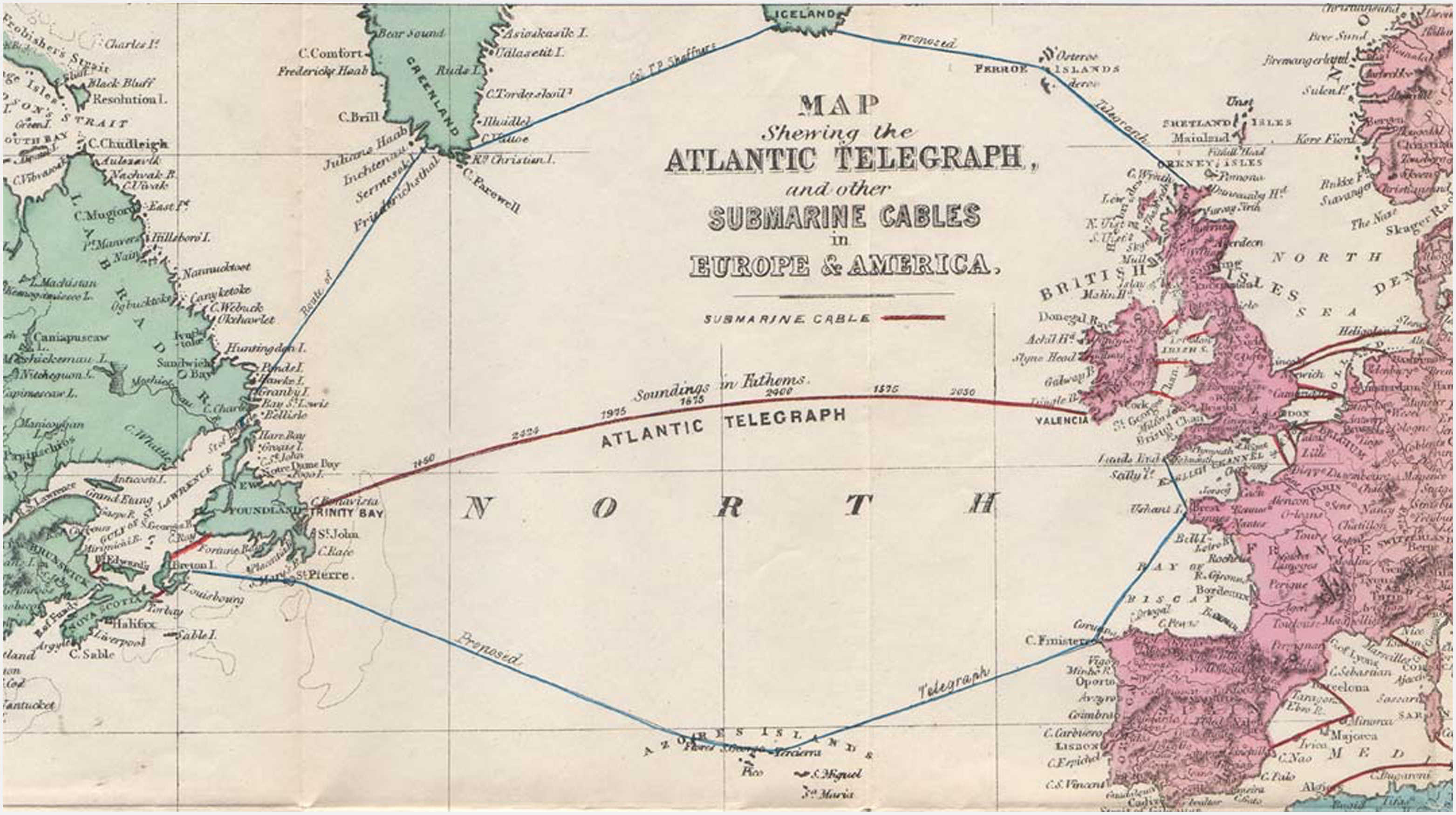
Shaffner had heard of the idea of a northern route over the Atlantic from a project spearheaded by the British Geographer to the Queen, James Wyld Jr., who had begun a similar project in 1852, but was unable to find capital for the project (Stephen, Reference Stephen1866). Shaffner’s Arctic alternative to the Transatlantic route was one that required only a total of 1750 miles of submarine telegraph cable, because he suggested dividing the line into four sections (see also Fig. 1):
first from the North of Scotland to the Bay of Thorshaven, Stömoe Isle, of the Faröe Isles (…) The next section will run from Westermanshaven, of the Same Isle, to about Portland, South Iceland, a distance of about 350 miles. From the Bay of Reikiavik the next section of cable will run to some bay on the east coast of Greenland, south of the latitude 61° north (…) the fourth section of cable will run from some of the bays of the west coast, south of the latitude 61° north, to Hamilton’s Inlet, on the Labrador coast.
(Shaffner, Reference Shaffner1859, p. 101)
Detail of map of the Transatlantic cable and Shaffner’s proposed Northern Route (The Atlantic Telegraph, 1866).
The central idea behind Shaffner’s Northern Route was thus to bring the cable over land as much as possible, where it could be accessed and repaired, and divide up submarine stretches, so that “[i]f either one of the sections fail, the whole are not lost, and another cable can be promptly submerged” (Shaffner, Reference Shaffner1859, p. 102), ensuring that the entire investment would not be wasted if a cable should break down, like the transatlantic cable in 1858. However, a route over land introduced new complications, one of which was political: Except for the cable’s beginning and end on British territory in Scotland and Labrador, the Arctic territories that Shaffner proposed to place land telegraph stretches on – the Faroe Islands, Iceland and Greenland – were part of the Kingdom of Denmark. To provide necessary context for these territories in plans for The Northern Line, I will briefly elaborate on the situation and position of the Faroe Islands, Iceland and Greenland in the Danish Kingdom at the time of Shaffner’s expeditions.
An illustrative term sometimes used in Denmark about the collective territories Faroe Islands, Iceland and Greenland in the 18th and 19th centuries (e.g. Zeilau’s publication on The Northern Route expeditions) was “biland” or dependency, while only the trade and mission stations in Greenland were called “colonies” (Petersen, Reference Petersen1995). This contrasted with Denmark’s other colonies (in the West-indies, Africa and India), where the term “colony” was used about the whole territory. This difference in terminology indicates that while the West Iindies, Africa and India were occupied explicitly for strategic and economic exploitation, the North Atlantic territories were regarded as inherited dependencies (Petersen, Reference Petersen1995). After the Napoleonic wars in 1815, the Danish-Norwegian kingdom was broken up, Norway ceded to Sweden, while the Faroe Islands, Iceland and Greenland remained Danish. Although the term “biland” seems to imply a territory of lesser status than the “main country,” it was actually preferred by Icelandic separatists to “colony” because it – at least tentatively – positioned the population “within the category of Western nations” (Ellenberger, Reference Ellenberger, Henningsen, Koivunen and Syrjämaa2009, p. 100). But each “biland” held quite different positions within the kingdom:
In the mid-19th century Faroes, the foundation for increased economic and political independence from Denmark was slowly emerging. A Danish trade monopoly had been abolished in 1856, which, alongside demographic growth, the establishment of export fishery and the reconstitution of the Faroese law assembly Løgtingið in 1852 strengthened the economy and brought about a new middle class (Wylie, Reference Wylie1987, p. 91). Paradoxically, the 19th century was also a period where The Faroe Islands were closer integrated with the Danish state than ever before. Formally, the Faroes became an “amt” or county in Denmark in 1816, while the Løgtingið functioned as a Danish county council. Conditions for a political Faroese separatist movement would not emerge until the 1920s among Faroese students in Copenhagen (Ibid, p. 6).
Contrasting both the Faroe Islands and Iceland, in the effort to protect Inuit culture, Greenland in the 19th century was almost completely closed off to foreign access and activity not explicitly permitted by the Danish state, as Danish politicians considered the Greenlandic people “too fragile to survive in a free market economy” (Thuesen, Marquardt, Seiding, & Frandsen, Reference Thuesen, Marquardt, Seiding, Frandsen and Gulløv2017, p. 199). While this was Denmark’s official position, Greenland’s isolation also secured a Danish monopoly on tradeables provided by Greenland’s traditional hunters (Gad, Reference Gad2014). Local Danish-led councils known as “forstanderskaber” were established around 1860 to supplement the royal state monopoly company KGH, but the Faroese trajectory of slow democratisation through assimilation as a county in Denmark happened a full century later in Greenland, in 1952.
While the Faroe Islands would not form a separatist movement until the 20th century, the first nationalist demands were formulated by Icelandic students in Copenhagen in the early 1830s (Hálfdanarson, Reference Hálfdanarson2000). In response to this growing Icelandic nationalism, Denmark issued a royal decree in 1843 to restore the historic Icelandic assembly Alþingi or Althing. Unlike the Faoese Løgtingið, the Alþingi received some legislative authority in 1874, when Icelanders acquired their own constitution (Ellenberger, Reference Ellenberger, Henningsen, Koivunen and Syrjämaa2009). The Danish trade monopoly in Iceland was also abolished much earlier than Greenland and the Faroe Islands, in 1787, but trade remained mostly under Danish control until 1855, when all Icelandic trade restrictions ended (ibid). Arguably, while Iceland was part of the Kingdom of Denmark at the time of The Northern Route, it had a special status within the Danish state as less foreign than the Faroe Islands and, in particular, Greenland. This was due, as mentioned, to the autonomy of Icelandic officials, but also their perceived shared Viking heritage, Iceland’s growing economic strength, and other factors (Agnarsdóttir, Reference Agnarsdóttir, Harris and Lévai2008; Ellenberger, Reference Ellenberger, Henningsen, Koivunen and Syrjämaa2009).
Foreign ministry records in the Danish National Archives show that Shaffner was in contact with the Danish government as early as 1853 about securing permission for the project, dating his interest in a land-oriented solution to at least five years prior to the first failed attempt at bridging the Atlantic Ocean with a submarine cable (record 74746). The isolationist line otherwise followed by Denmark at the time in relation to Greenland does not appear to have posed a hindrance, as Shaffner received a grant of Letters Patent by His Majesty Frederick VII, King of Denmark, given August 16, 1854, for the exclusive right to lay a line over Greenland, Iceland, and the Faeroe Islands to Denmark for 100 years. The line was to be complete in ten years or have at least £10,000 sterling expended upon it, within three years, under a penalty of either forfeiting the concession, or paying a fine equal to the said sum (Joint committee to inquire into the construction of submarine telegraph cables, 1861). In a study of Icelandic telecommunications cables, Johnson remarks that the concession then passed to the Icelandic Parliament, where it “languished over the next seven years” (Johnson, Reference Johnson2021, p. 582). However, no sources indicate that Shaffner nor anyone else involved in plans for The Northern Route considered or were even aware of the Icelandic reluctance, expressed at a time where Iceland did not yet have any legislative authority in the Kingdom of Denmark. Shaffner could therefore, in his later presentation of The Northern Route to the British Royal Geographical Society, reassure the members present that “There is no monopoly of the line reserved for the Danish Government, but its impartial use is guaranteed to the whole world” (Shaffner, Reference Shaffner1859, p. 101).
Not even snow for a snowball
Skipping ahead in the story, we might already be at this early point in the analysis of The Northern Route turn to its abandonment in 1866 and the reasons given for this. Contemporary British newspapers, who were more vocal on the unsuccessful fate of the project than Shaffner’s American compatriots, offered numerous reasons for the project’s failure:
The Scottish John o’ Groat Journal stated that the abandonment of The Northern Route owed “partly, it is said, to outbreak of the American war” and the Morning Post concurred that “the political and financial state of America may for some years have afforded a reasonable excuse for the failure” (John o’ Groat Journal (Caithness), 15 February 1866; The Morning Post (London), 25 August 1865). However, The Dundee Courier and Argus in 1866 held that “no progress has ever been made in carrying out this scheme,” while The Scotsman the same year made the gentler observation that Shaffner’s scheme had broken down because his “influence was not sufficiently satisfactory to British capitalists” (The Dundee Courier and Argus, 22 March 1866; The Scotsman (Edinburgh), 17 April 1866). Finally, in 1882 The Globe with the benefit of hindsight surmised that the entire idea had “looked too bold, not to say impracticable” (The Globe (London), May 18 1882).
The outbreak of the American civil war does appear to have been an important obstacle for The Northern Route. Shaffner travelled back to America to aid the Union in 1861, just as the second survey expedition had returned from Greenland, which probably caused significant delay, if not concern about the solidity of the project. His absence in Europe and subsequent suspension of activities could have led to a forfeiture of the concession from Denmark, which, as mentioned, required a finished line within ten years. Still, the varied icy British assessments of Shaffner’s scheme indicate that other factors had also been at play. In fact, as I will argue in the following, a central actor in the fate of the Northern Route was ice.
In 1859, Shaffner visited Greenland for the first time to survey a possible route for the telegraph. He landed at “Julianshaab” in South Greenland, current-day Qaqortoq, and travelled from there to Iceland and finally Glasgow on the bark Wyman with his family (Shaffner, Reference Shaffner1859, p. 105). According to the Danish lieutenant Zeilau, Shaffner’s later affiliate and fellow traveller, the small bark was “14 years old and without any Equipment for Ice-navigation, not even the necessary Sea-maps for such a Journey” (Zeilau, Reference Zeilau1861, p. 10. In this and subsequent quotes, the text has been translated from Danish by the article’s author). But the expedition was a great success, and Shaffner and company had found the anticipated difficult waters of Greenland very easy to navigate:
The waters are as often free of Ice Floes, but he was especially lucky to have made his Arrival in an unusually “good Ice Year.” This is a technical Phrase in Greenland and means a Year in which the Spitsbergen-Floe Ice only in small quantities gets around Cap Farewell and floats up along the Coast of West Greenland. The Opposite is called a “bad Ice Year.” Shaffner arrived in 1859, which, as mentioned, was a particularly good Ice Year.
(Zeilau, Reference Zeilau1861, p. 12)
With luck seemingly on his side, Shaffner arrived from this journey in Britain with great enthusiasm and confidence in The Northern Route. There, he was able to gather interest for a telegraph route over Arctic territories, which, as we saw above, was otherwise regarded as “bold and impracticable.” In his enthusiastic tales of the trip, Shaffner even went as far as stating that in Greenland, he had “without Success sought out enough Snow even as needed for a Snowball” (Zeilau, Reference Zeilau1861, p. 15).
The “good Ice Year” in Shaffner’s early trip to Greenland, which arguably made the journey possible, would, however, prove to be a double-edged sword. The expedition to Greenland had instilled a confidence in Shaffner that snow and ice would prove no obstacle, but his stories in 1859 and 1860 of conditions in the Arctic directly countered much of the current public and scientific knowledge of the region, and Greenland in particular. In Zeilau’s travel journal from 1861, the contemporary public perception of Greenland was summarised as:
[A] Country, curbed by Ice, with an almost unreachable Coastline, where you could not sail without being caught by the Floe Ice or becoming pitifully overrun by Icebergs (…) Electrical Storms, Hurricanes, deathly cold, Snow, Icebergs, Polar Bears and other horrors of the Polar Region was what you connected Greenland with, as people mistakenly thought of the North Pole and pure forgot that Cape Farewell is on the same Latitude as Christiania [Oslo] and Skt. Petersburg.
(1861, p. 14)
This imaginary of Greenland was of course the principal challenge to any activity involving the region. However, while ice in abundance was a difficult material to negotiate, in its absence it could also prove a treacherous ally, since a traveller returning from explorations in the Arctic regions in the 1860s was expected to report back depicting particular conditions.
In the case of the Northern Route, ice is a curious actor, as it both acts in a very direct sense, making possible, through its absence in parts of the sea around Greenland in 1859, Schaffner’s first expedition. But ice also acts through the stories that are told about it, as there are strong imaginaries attached to ice, especially among those who live furthest from it. As indicated by Zeilau’s depiction above, ice and snow were understood as something that overwhelmed and dwarfed humans, not something manageable. Numerous expeditions had sought (and failed) to find the Northwest Passage over Canada in the preceding years, drawing increased attention to the Arctic, while expedition reports provided fuel for the public imagination:
Sixteenth- and seventeenth-century explorers and chroniclers provided images that would impress later writers with a sense that in the Arctic Nature was somehow vaster, more mysterious, and more terrible than elsewhere on the globe – a region in which natural phenomena could take strange, almost supernatural forms, sometimes stunningly beautiful, sometimes terrifying, often both.
(Loomis, Reference Loomis, Knoepflmacher and Tennyson1977, p. 96)
Following an increased influx of stories from explorers in the early 19th century, the Arctic became a trope in pre-Victorian and Victorian literature such as Coleridge’s The Ancient Mariner, Shelley’s Frankenstein and Dickens’ The Frozen Deep. Arctic imagery represented the Sublime, a greatness, which was both terrible and awe-inspiring, beyond imitation and measurement, and thus, unmappable.
In contrast, Shaffner had seen Arctic climatic conditions which were in complete opposition to popular knowledge of ice in the mid-1800s; one in which Arctic ice and snow was not necessarily a constant or even a barrier to infrastructural development. As with many other facets of ice in the Arctic, the existence of a “good” or “bad” Ice Year was not known in London in 1860. Thus, when Shaffner proclaimed that constructing a large infrastructure across Arctic territories was not only possible, but could be completed without much trouble from ice and snow, he appeared to fully disregard an actor that had circulated as a principal obstacle in expedition reports, the press, and the arts. As a result, Shaffner played into the hands of those who had emerged as supporters of the Transatlantic line, who were sceptical – for many reasons – of a northern route.
Beyond the arts, the press and the telegraph community, the British scientific communities made up another group who regarded Shaffner’s reports about a possible northern route for transatlantic cable telegraphy with interest – and scepticism. In particular, the Royal Geographical Society in London, which had been founded in 1830 by, among others, Arctic Explorer John Franklin, were instrumental in offering Shaffner an audience for his insights, and a possible route to funding. Here, in an invited presentation of the Northern Route for the Society in 1860, Shaffner detailed his impressions of East Greenland in 1859, underscoring the non-existent threat from the climate, and the ice in particular:
On the east coast neither the berg nor the floe ice penetrates the bays and a cable laid therein would never be disturbed by them even were the waters shallow. The hills on the coast are covered with grass and berry bushes. The climate is not severe. The native ice is not very thick; and if it were, the cable would not be injured by it.
(Shaffner, Reference Shaffner1859, pp. 104–105)
In response to Shaffner’s account, the Society’s fellows present that day in London had numerous concerns. Some were sceptical of Shaffner’s argument that a Transatlantic cable was impossible, some argued for the disturbing effect of terrestrial magnetism in the Arctic. Others worried about the required dependence on Denmark, while some focused on the missing knowledge about the ocean floor (Shaffner, Reference Shaffner1859), as systematic oceanographic research would not commence until about a decade later (Wüst, Reference Wüst1964). However, the central objection from the learned Society’ fellows was, as expressed by Mr. Lionel Gisborne, F.R.G.S (Fellow of the Royal Geographical Society), “the question of icebergs”:
(…) there were other questions to be investigated connected with the working of the line, principally the question of icebergs. He [Mr. Gisborne] had the opinion that icebergs were prevalent about Iceland, Greenland, and Labrador; and if Colonel Shaffner could show that there were inlets and bays on the coast in which a cable could be landed safe from the effects of icebergs, he would have established a fact not generally known, and a most important fact in the physical geography of that country. (Shaffner, Reference Shaffner1859, p. 106)
Next to take the word at the meeting was Mr. Wortley, F.R.G.S., who regarded Shaffner’s story of ice in Greenland with additional suspicion. To dispel Shaffner’s implausible account, Mr. Wortley had acquired the logs of Shaffner’s ship, the Wyman, where he had found evidence that Shaffner was indeed deceitful, as they had been “beset with ice” during the trip:
It was new to hear that the east coast of Greenland was free from ice. In Norie’s chart the whole of that coast was designated as an impenetrable field of ice; and he [Mr. Wortley] held in his hand the log of the vessel in which Colonel Shaffner sailed, and it was there stated that they were beset with ice at one time and lost all control of their vessel, and that at other places they saw thousands of icebergs. Enough had been learned to show that at all seasons of the year there would be considerable danger not only in navigating those seas, but also in laying a cable worth two or three hundred thousand pounds.
(Shaffner, Reference Shaffner1859, p. 107)
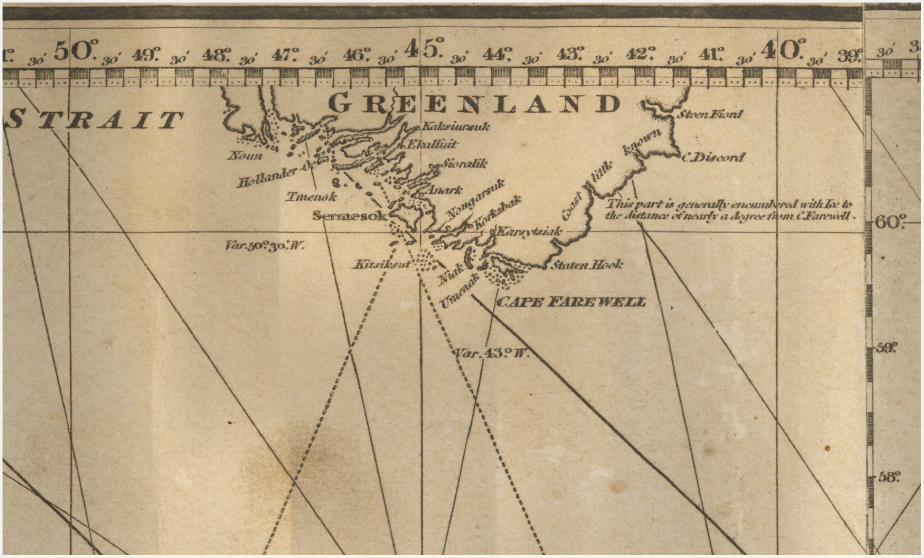
Shaffner’s initial return from the Arctic was thus received with varying degrees of hesitance in The Royal Geographical Society, if not outright disbelief. Shaffner’s narrative of an ice and snow-free Greenland had – to some – revealed him as someone who was not knowledgeable of or qualified to assess Arctic ice. Shaffner arrived in London as a “yankee” outsider, meaning that he had difficulties forging alliances in the British scientific community’s already-established groups (Zeilau, Reference Zeilau1861, p. 15). Moreover, Shaffmer contradicted highly esteemed expert sources of knowledge about Arctic geography and the widespread opinion in the nineteenth and twentieth centuries that the Arctic was always covered by perennial ice, both on large parts of its land mass and on the Arctic Sea (Sörlin, Reference Sörlin, Evengård, Nymand Larsen and Paasche2015). The Norie mentioned in Wortley’s speech was John William Norie (1772 – 1843), a respected British chart maker, hydrographer and publisher of nautical books. See, for instance, Fig. 2 depicting a detail from a 1828 Norie map of the Atlantic ocean, presumably similar to the one rereferred to by Mr. Wortley, where East Greenland is described as a region that “is generally encumbered with Ice.”
Detail, a new chart of the Atlantic or Western ocean improved by W. Heather. A new edition. Drawn revised and corrected by J.W. Norie, Hydrographer & co. 1828.
However, several of the Society’s fellows, such as Mr. Gisborne, also allowed for the fact that Shaffner’s ideas might bring forth important information. As Sörlin notes, systematic studies of ice in Western traditions were established relatively late, after the theory of ice ages in the mid-19th century, which drew interest to terrestrial ice as expressions of the Earth’s prehistory (Reference Sörlin, Evengård, Nymand Larsen and Paasche2015, p. 329). Thus, at the time of Shaffner’s meeting with the Royal Geographical society, studies of sea ice and terrestrial ice were rare among Euro-American scholars, and oceanography and glaciology were only just emerging as scientific fields with dedicated expertise and data collection. Additionally, large parts of Arctic were uncharted or only cursorily mapped in 1860, for example parts of Iceland, inland Greenland and North and East Greenland (McCannon, Reference McCannon, Nuttall, Christensen and Siegert2018; Zeilau, Reference Zeilau1861).
Maps thus were – as they are today – crucial actors in both defining and sustaining what the Arctic, its ice, waters and territories are understood to be. As we see in the earlier quote, charts, logs and maps could contest human eye-witness testimony from those arriving directly from their depicted territories. In addition, knowledge about the Arctic was primarily accepted when it came from actors, who either were part of or recognised as similar to the existing members of The Geographical Society. In Shaffner’s case, however, he also offered The Society an occasion to go where no maps yet existed that could contradict his claims, i.e. the bottom of the ocean, which did speak in favour of The Northern Route.
Securing allies
From the reception in London in 1860, it was clear that to secure support and acquire funding from Britain to realise a North Atlantic Telegraph Route, further evidence was needed of the feasibility of Shaffner’s idea, or to express it in the words of Sir Edward Belcher, F.G.R.S. “We want the facts as to the true nature of the bottom determined before any attempt was made to lay a cable” (Shaffner, Reference Shaffner1859, p. 108). To attain what the Royal Geographical Society recognised as “facts,” additional studies of conditions in the sea and on land in the Faroe Islands, Iceland and Greenland were required, but crucially, qualified observers – from the perspective of Britain’s scientific community – were needed. Here, the Society played a major role in connecting Shaffner with actors who unlike Shaffner himself were perceived as credible and knowledgeable in relation to the Arctic and its ice: To this effect, renowned Polar explorers and Royal Geographical Society Fellows Leopold McClintock, John Rae, Allen Young were recruited as well as two steam-powered vessels, the yacht Fox and the paddle sloop HMS Bulldog, which, in contrast to Shaffner’s vessel on the first expedition had been specifically modified for navigation in icy waters. These actors set out for expeditions to The Faroe Islands, Iceland and Greenland to study ice, sea depths and conditions on land and assess the prospects of a future Northern Route (McClintock, Reference McClintock1860; Shaffner, Reference Shaffner1859; Zeilau, Reference Zeilau1861).
In 1860, after Shaffner’s meeting with the scientific society, two separate expeditions were thus dispatched. Counting Shaffner’s journey on the Wyman in 1859 as the first, a second expedition was sponsored by the British crown on the behest of Lord Palmerston and undertaken by the Irish explorer Francis Leopold McClintock on the HMS Bulldog. The purpose of the Bulldog expedition was to sound the bottom of the sea and study ice conditions (Madsen, Reference Madsen1884; Zeilau, Reference Zeilau1861). A third expedition, simultaneously with the second, focused on conditions on land, where, to the largest possible degree, the cable would run. Travelling on the Fox and sponsored by the wealthy American merchant J. R. Croskey, the expedition was led by the English mariner and explorer Allen Young, accompanied by Shaffner, the Scottish surgeon John Rae and two delegates for the Danish government, the Danish lieutenant Theodor Zeilau quoted earlier, and the Icelandic Althingsmand Arnljótur Ólafsson (Bricka, Reference Bricka1898; Zeilau, Reference Zeilau1861).
The addition of a Danish delegation was a diplomatic move for an endeavour that was reliant on the goodwill of the Danish Crown, but vessels and people from Britain were clearly chosen for their expertise and trustworthiness in Arctic matters. In fact, despite their apparent daunting scope, the Fox and Bulldog expeditions to the Faroe Islands, Iceland and Greenland in 1860 exist as mere footnotes in the legacies of both the Fox, Young, Rae and McClintock. For several of the key actors in the Northern Telegraph expeditions, trustworthiness in matters of ice came from on their renown, acquired a few years earlier during the search for the Franklin expedition, which was lost in the Canadian Arctic in 1845 in an attempt to find the Northwest Passage, briefly outlined here:
In a period of mounting concern in Franklin’s native England, McClintock had undertaken no less than four expeditions in the effort to save Lord Franklin, or at least uncover his fate. However, it was not until 1857 with sailing master Allen Young on the Fox, which had been bought by Lord Franklin’s wife Lady Franklin and adapted to Arctic conditions, that he encountered the lost expedition’s remains and were credited as having discovered its grim fate: All men had died. During a solo expedition in the area, another member of the later Northern Route expeditions, Dr John Rae, had discovered the fate of the Franklin expedition no less than three years earlier, in 1854. However, Rae’s reports had caused a scandal in Victorian England and were dismissed due to his conclusion, based on local Inuit sources, that the ill-fated Franklin expedition members had engaged in cannibalism (Cavell, Reference Cavell2013). Inuit accounts of cannibalism were corroborated by later studies of remains from the expedition, but were widely distrusted at the time, and Rae’s conclusions were omitted in publications on both Rae and the Franklin expedition well into the 20th century (Gibson, Reference Gibson1937; Mays & Beattie, Reference Mays and Beattie2016; Mitchell, Reference Mitchell1933).
When the Fox and the Bulldog expedition set out, it was thus not so much as part of a new endeavour than as a continuation of Victorian attempts at securing large-scale infrastructural development in the Arctic. In the first chapter, the search for the Northwest Passage, which would ostensibly establish a valuable transport route, was told as a series of “tests of the prowess of red-blooded men in a place of terrifying spaces, towering icebergs of wondrous forms, and inhuman coldness” (Martin, Reference Martin1994, p. 198). This first chapter, of course, had also turned into a search for the missing Franklin expedition and a slow realisation of its fate, which meant that in 1860, “Victorian awareness of the Arctic was at its most intense – and at its grimmest” (Loomis, Reference Loomis, Knoepflmacher and Tennyson1977, p. 100).
Credible ice witnesses
Despite the ominous backdrop of the Franklin expedition and Capt. Allen Young’s description of the Fox expedition as “a perilous journey” due to the amount of sea ice in 1860–1861 at the coast of Greenland (Bright, Reference Bright1860, p. 78), both expeditions nevertheless transpired without significant complications.
The expeditions, which of course primarily functioned to chart a possible route for a Northern cable, also appear to have been viewed as opportunities to further scientific knowledge about ice in the Arctic region, and the development of a more specific vocabulary about ice in the geographical community. When returning to Britain and reporting back on their surveys, both McClintock, Young and Rae consequently used the occasion to relay what they had learned in this regard. In particular, the northernmost part of the journey, in Greenland, was given special attention, such as in McClintock’s description of climatic conditions near Julianshaab/ Qaqortoq:
This coast, I may remark, is usually quite free from ice by September. Following up my inquiries, I learned that the climate is not nearly so severe as is generally supposed, the fiords are only partially frozen over in winter; a few cows, goats and poultry are reared; and although the summers are cold, turnips spinach, lettuce, and radishes grow in the open air.
(McClintock, Reference McClintock1860, p. 67)
These reports worked to juxtapose their findings with existing Victorian conceptions about the merciless Arctic nature by weaving in descriptions of a recognisable quotidian life with familiar crops, livestock and living conditions. In addition, Young was careful to distinguish between classes of icebergs as well as differences between “the West ice,” and the Spitzbergen, which he pointed out in Greenland was called “Store ice,” and how both forms of ice, while prevalent in Greenland, did not constitute uniform impenetrable walls, but rather allowed for open sea in the West and also became quite broken up during its journey along the coast (Bright, Reference Bright1860, pp. 76–77). However, it should be clarified that it appears from the terminology (“Store” meaning large in Danish) as well as Zeilau’s description of their stay, that much of – if not all – of the knowledge gained in Greenland came from communication with the Danish colonial leadership, rather than Inuit in Julianshaab/ Qaqortoq (Zeilau, Reference Zeilau1861).
While the expeditions, through surveys, had established an image of current climatic conditions in Greenland, Iceland and Faroe Islands, they were also dependent on, and seem to have actively sought out, the local vocabulary and history of ice. Much of the information gained on these expeditions, as indicated by Young’s attention to the terminology of ice in Greenland and McClintock’s reference to “inquiries” above, was thus dependent on Icelandic, Faroese and Greenlandic knowledge about local ice and snow. Local aid also extended to accompany the expedition and repair their equipment, as well as lending or renting out local technology and modes of transportation suitable for icy and snowy conditions, such as small, hardy Icelandic horses to cross Iceland, an umiaq (boat rowed by Greenlandic women) and a sledge to explore South Greenland.
Drawing on their own expertise, but also to a large degree on local assistance, knowledge, and technology, both expeditions successfully charted a possible course for a Northern Telegraph Route by sea and by land (Zeilau, Reference Zeilau1861). In 1861, presentations at The Royal Geographical Society in London summarised their main findings: Suitable landing places for the cables had been surveyed and adjusted from the initial plan, but both in the case of the Faroe Islands, Iceland and Greenland, Allen Young expressed confidence that a cable could be landed without damage from current, humans, drift-ice, or icebergs (Bright, Reference Bright1860). In the Faroe Islands, the expedition depended on local knowledge about the swift Spring ebb and flow of the coastal waters, known as “fald,” to identify a location (Haldervig) without much current and sailing activity, as it was speculated that anchors might damage the cable (Zeilau, Reference Zeilau1861, p. 37). In Iceland, the expedition again relied on local sources to establish that no icebergs ever entered the surveyed landing spot, Beru Fiord, which was also known to have never frozen over (Zeilau, Reference Zeilau1861, p. 123). In the south of Greenland, “Julianshaab Fiord,” outside present-day Qaqortoq, Young’s soundings established that the fiord was sufficiently deep that it would “preclude injury to the cable from the largest icebergs ever seen upon the coast” (Bright, Reference Bright1860, p. 75). As summarised by the stoic McClinton, they returned with a favourable view of the plan as a whole:
I am of opinion that with regard to the practicability of laying a North Atlantic cable there are no grounds for serious misgivings; on the contrary, nearly all the information which has so far been ascertained is of a kind favourable to the accomplishment of the undertaking
(McClintock, Reference McClintock1860, p. 69)
With these testimonies from the Fox and Bulldog expeditions, The Royal Geographical Society in London was once again the frame for scholarly debate about the feasibility of the Northern Route. The response showed that Young, McClintock and Rae were valuable allies to the project, as they, unlike Shaffner the year before, were received as what we might, with inspiration from Callon’s term “spokesmen,” call “credible ice witnesses” (Callon, Reference Callon and Law1986): An actor that is able to speak and act on behalf of others, in this case ice and snow. Shaffner had tried to speak on behalf of ice, but had failed because ice and snow were already entangled with the literatures, maps, charts and ship logs of mid-19th century Britain, who were brought out to speak against him. In response, the Royal Geographical Society appointed their own spokesmen. Trust was placed in ”the distinguished travellers and navigators” who had given the society members “sufficient authority to say that there were obstacles on the route undoubtedly, but that all those obstacles are surmountable,” as expressed by Captain Sherard Osborn (Ashburton, Reference Ashburton1860, p. 101).
While the alliance between The Northern Route and credible ice witnesses Young, McClintock and Rae was successful in establishing trust in ice conditions along the route, their status as Great Men of Arctic Exploration was also, perhaps surprisingly, an obstacle. As presented in the objections from a Mr. John Ball in The Royal Geographical Society’s debate:
It is true that it is possible to cross Iceland – perfectly possible – but so experienced a traveller as Dr. Rae found that it was not practicable without very great sacrifice of time, and encountering great difficulties to take that direct route; but had he at all considered what were the difficulties and cost of laying down a telegraphic wire?
(Ashburton, Reference Ashburton1860, p. 102)
This hesitation stemmed from the fact that Young, McClintock and Rae were understood to be no ordinary men, but famed explorers. The same quality that led the geographic community to trust their testimony thus meant that their success – ascribed to extraordinary skills and courage – could not be translated to the difficult infrastructural efforts presumably involved in laying down a fragile telegraphic wire. The Arctic, despite details in the expedition reports about summers “remarkable for their warmth,” local everyday life and green vegetation (McClintock, Reference McClintock1860, p. 67), was still predominantly positioned as Sublime: Inhuman, unmappable – and possibly un-buildable.
The comparative politics of cables
As we know, The Northern Route, despite interest from communities in Britain, Denmark and United States, was never realised. Five years after the above debate in The Royal Geographical Society, the direct Transatlantic Telegraph Line was inaugurated, dampening interest in alternative routes. The Northern Route’s lack of progress in the interlying years thus appears to have been significant in determining that this global infrastructure circumvented the Arctic. So why was the project not realised, or at least delayed for so long that other alternatives took over?
According to British media in the 1860s and 70s, the development was certainly partly due to the outbreak of the Civil war, as Shaffner as central driver disappeared, and funding from the US proved more difficult to attain. As also discussed, the hesitation that a costly and fragile infrastructure might be established along the same route that had previously only (or that was the imaginary) been traversed by Great Men of Arctic Exploration was significant factors. This is supported by Shaffner’s contemporary, the British engineer Bright, who in his volume The Story of the Atlantic Cable concludes that “there were those who still feared the ice-floes; and in the end the public did not respond sufficiently” (Bright, Reference Bright1903). However, a final obstacle of central importance which Bright does not touch upon was that the Arctic itself held little to no value in The Northern Route. As expressed by Mr. Lionel Gisborne of the Royal Geographical Society, in response to Shaffner’s initial presentation of the plan:
What advantage was there in the proposed route when the two termini of the line would be such a long distance from the points wanted to be reached – London and New York? Taking a broad view of the question, he [Mr. Lionel Gisborne] should not be disposed to go to a part of the world with such a delicate thing as electricity, where every book on the subject shoved there were currents, great differences of temperature, icebergs, and changes in the formation of the country, to be encountered. The only advantage offered by Colonel Shaffner was that of having a fresh battery every 500 or 600 miles; that was an immense advantage; and if it could be proved that the difficulties to which he had referred did not exist, then, undoubtedly, the route proposed would have advantages not possessed by any other in that respect.
(Shaffner, Reference Shaffner1859, p. 106)
To the British scientific community, the Arctic was a substrate, a seemingly necessary foundation for the telegraph wire. If not for the technical concerns about the length of the wire underwater, the land sections of The Northern Route were liabilities, their communities were not recipients, and their territory merely support for the thread.
We see this understanding of the Arctic as substrate reflected as well in the way the local population was assessed by the expedition participants first and foremost as possible threats to the project. Locals were sources of aid and information, but never recipients of the connection afforded by the cable, and no landing sites were considered in relation to local needs. The most diligent assessor in these matters was the physician Rae, who made careful appraisals of the population in reports upon his return to Britain. Rae described the inhabitants of the Faroes as appearing generally “well educated and religious, and so fully aware of the advantages they would derive from a telegraph being carried through their island, that they would use their best efforts to protect it from injury” (Rae, Reference Rae1860, p. 75). The Icelandic population were “able and active, wherever we went we were received with much kindness and hospitality, and even at the poorest cottages milk, coffee and brandy were handed to us. All classes seem more or less educated, and the Lutheran religion prevails” (Rae, Reference Rae1860, pp. 88–89), while the Greenlanders were characterised as “honest, docile and well conducted, doing great credit to the Danish government. The prevailing form of worship is Lutheran” (Rae, Reference Rae1860, p. 90).
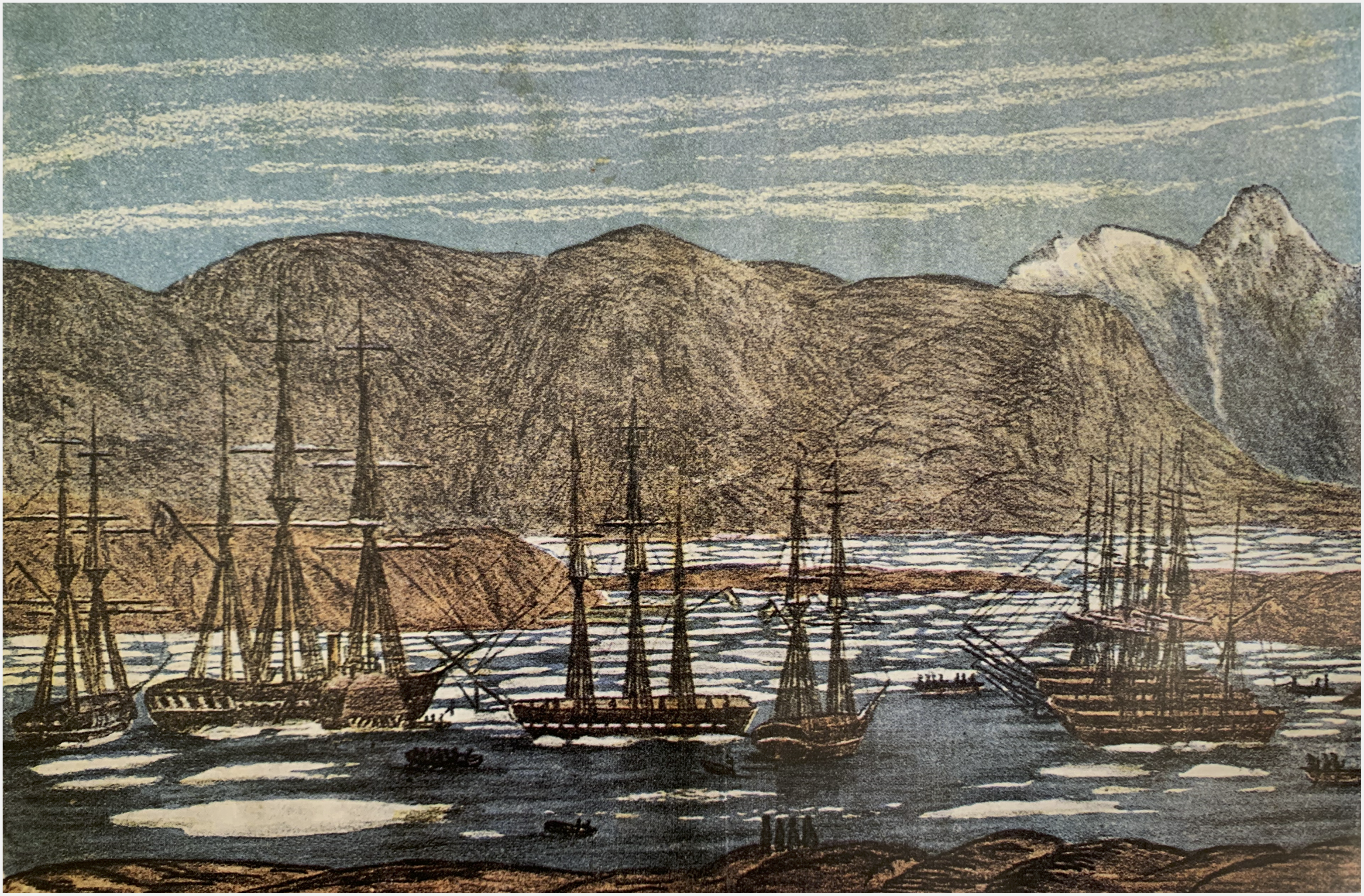
We see here how the dispatched “credible ice witnesses,” in addition to geographic and climatic conditions, considered the degree to which the local population would assist or hinder their plans, in evaluations which factor in disturbance from heathen religious communities, aggression and education level. In jarring contrast to this, threat assessment approach to local citizens was the great interest in “the thread” from Faroese and Icelandic inhabitants (Zeilau, Reference Zeilau1861, p. 81). In Greenland, the front page of the 1861 first publication of Greenland’s still-running national newspaper Atuagagdliutit featured an image of Shaffner’s “Fox” and the accompanying “Bulldog” arriving in Nuuk harbour (see Fig. 3), as well as an article describing the expedition and the project. However, from Rae’s reports, it is unclear which “advantages” inhabitants alongside the route would, in fact, be afforded. The Danish representative, Zeilau, seems to have touched upon it in a speech before his departure from London, where he in flowery terms described a community uniting the people along the thread:
It is a curious coincidence that this line along all its points should find populaces who originate from the same lineage – at the one end the Scandinavians, from whom originate the Anglo-Saxons, and at the other their descendants: Americans. This line traverses a triad of countries whose people have the same blood in their veins. But there is another curious similarity; all the governments of these countries are based on true freedom, and it is worth hoping that this line, which will naturally bring dispatches for other countries, with them may also send some of that freedom-spirit, which we are all imbued with.
(Zeilau, Reference Zeilau1861, p. 28)
Woodcut illustrating the ‘Fox’ and the ‘Bulldog’ by Rasmus Berthelsen from watercolour by Aron fra Kangeq. For Peer.
Zeilau’s thoughts on the possible impact of the telegraph on the Faroe Islands, Iceland and Greenland thus centre on an anticipated “freedom spirit” emanating from the messages between Denmark, England and America. While it was, for its time, an ambitious vision that involved a telegraph line across the Arctic, Zeilau never went as far as imagining any communication from, for, or within the Faroe Islands, Iceland and Greenland. Rather, Zeilau performed a kind of ordering of the peoples along the line, grouping some together by lineage, some by the opaque “blood.” Ordering of this kind was foundational to the telegraph project, a “politics of comparison” (Pram Gad, Reference Pram Gad2021; Stoler, Reference Stoler2001), if we think of comparison not as a methodology but as a way of tracing what the actors involved in infrastructural development thought to compare, and what made them do so. In this case, actors drew things together that appeared to them as similar, or desirable, while disregarding that which appeared as separate, or unwanted. In his most lofty dreams, Zeilau imagined Arctic development emerging as a by-product of transferring messages across the Atlantic Ocean, between Scandinavians, Anglo-Saxons and the Americans.
In his own reports and travel journal, Zeilau did not return to this idea of freedom spirit emanating along the telegraph wire in relation to his travels in the Faroes, Iceland and Greenland. Rather, he seemed to have had a special interest in conditions in the Danish kingdom and primarily used the expedition as an occasion to inspect the cleanliness and sobriety level in the Danish dependencies. Zeilau had these remarks following a stay at a wealthy Farmer in Kollefjord/Kollafjørðurer, Faroe Islands, where he asked to look around:
He [the farmer] concurred straight away and let me into the “Smoke-room,” where his Daughters were diligently occupied with karting, knitting etc. – for he had a lot, no less than five, and moreover so beautiful that the Lieutenant easily could have forgotten to look elsewhere if he had not been so determined to find at least some of the Filth so often mentioned. It must be somewhere; but no – although I bravely withstood Temptation as befits my Position and used my Eyes well in that regard, I must defer to my first Sentence and repeat, that Everything was in exemplary Order.
(Zeilau, Reference Zeilau1861, p. 40)
Zeilau approached this task with much zealousness and thoroughly inspected and took notes on each home the expedition stayed in along the route – although one gets the impression from his journal that he often, as in the above example, used these self-appointed inspections as an excuse for scrutinising local women. There is no indication that the cleanliness inspections were based on orders from Denmark, but Zeilau appeared to see himself primarily as a colonial administrator or inspector rather than a surveyor for an infrastructural project with landing sites and telegraph stations that might potentially benefit communities across the Kingdom of Denmark.
Looking beyond the actors directly involved in The Northern Route, it seems that politics of comparison played a central role in drawing all telegraph lines of the 19th and 20th century. In her study on the formative “class of 1866,” Müller argues that the eventually successful transatlantic telegraph cable between London and New York led to the formation of a global “cable community” with a clear centre-periphery structure “Cables were being laid from Europe or rather from London to a certain place without reciprocity” (Müller, Reference Müller2010, p. 250). Subsequent cables would uphold, rather than challenge this terrain. Underlining this, Müller refers to the historian A.W. Holland who in a 1914 publication on the Atlantic cable asserts that while a cable between Greenland and South America would have been equally achievable, the connection would not have had any value:
The Eskimos in Greenland would not want to know anything about the tall and strange and copper-coloured inhabitants of Tierra del Fuego, and even if they did, they would not be able to understand each other’s signs.
(Müller, Reference Müller2010, p. 256)
Inhabitants in the Arctic, despite significant local investment and interest in the project, were thus not viewed as a desirable – or perhaps even meaningful – partners for Shaffner or other in the emerging cable communities. Prior to the 1866 direct telegraph connection across the Atlantic, communities in science, commerce and politics were establishing themselves in Europe and North America who were approaching the technology as means to achieve as stable, direct, and fast connection between these two points as possible. Local inhabitants in the Faroe Islands, Iceland and Greenland were actors, in so far as their knowledge about climatic conditions was recorded and their terminology sometimes adopted in scientific communities, but they were not beneficiaries, nor did they influence decision-making, mirroring trends across the Arctic during large-scale modernisation in the 20th century (Schweitzer, Povoroznyuk, & Schiesser, Reference Schweitzer, Povoroznyuk and Schiesser2017). The potential of the Arctic in relation to The Northern Route was always through national or transnational Western projects, where perceived ownership of Arctic territories increased or decreased in relation to which points needed connecting, and how.
Epilogue: the conservatism of north Atlantic cable infrastructures
As Star’s famously observed in “The Ethnography of Infrastructure,” infrastructural systems do not grow de novo, but wrestle with an inertia that comes from relying on an already-established base – power lines, airports or, in this case, submarine cables (Star, Reference Star1999). It would therefore be surprising if developments in The Northern Route did not influence later infrastructure in the North Atlantic. This epilogue to the history of The Northern Route is necessarily brief, providing only an indication of the ways in which current tele-infrastructures in Iceland, Greenland and the Faroe Islands are still shaped by this cryo-history of telegraph cables, a matter that will hopefully be detailed in future studies.
Shifting motivations for establishing telecommunication infrastructure over Arctic territories re-invigorated versions of The Northern Route several times in the late 19th and early 20th century. First, led by the British geographer James Wyld, and in 1868 a Danish concession (Madsen, Reference Madsen1884). In 1880, GN Store Nord/ The Great Northern Telegraph Company took over parts of the project, with the goal now framed as weather warning rather than commerce, and in 1906 GN opened a cable from the Shetland Islands to the Faroe Islands (Jacobsen, Reference Jacobsen2019). The final section of The Northern Route was completed in 1961, when the ICECAN coaxial cable connecting Iceland and Canada, owned and operated by the British Post Office, GN and the Danish Post and Telegraph Company landed in South Greenland at Narsarmijit/Frederiksdal. However, while able to sustain a limited amount of transatlantic telephone conversations, ICECAN was not made to serve inhabitants of Greenland, but rather the civil aviation authorities of 14 countries whose airlines flew over the Arctic (https://www.ambaile.org.uk/asset/5139/). It was therefore arguably not through a cabled connection, but at the inauguration of the first wireless radio station in 1925 in Qeqertarsuaq, that permanent and direct telecommunication was established to Greenland.
In her study of three communication cables to Iceland, Johnson notes how the country’s ongoing entanglement with the Danish empire meant that in 1905, Iceland’s first telegraphic connection cable landed at Seyðisfjörður on the east coast (towards Denmark), despite Icelandic insistence that they needed a connection to Reykjavik, their seat of government in the West. It was therefore a materialization of sovereignty when Iceland, in a rebellion against the already-established infrastructural base, invested in DANICE, a cable established in 2009 that runs directly to Reykjavik (Johnson, Reference Johnson2021).
In Greenland, during the digital transformation of the early 2000s, the telecommunication industry struggled with limited satellite capacity, a bottleneck that was impossible to circumvent without a cabled connection to its major cities on the West coast. Representatives from Tusass therefore contacted global undersea cable suppliers to present their plans for a submarine fibre optic Internet cable connecting Greenland with Canada in the west and Iceland in the east. When representatives from Tusass went out for meetings, however, suppliers did not take them seriously when they proposed the construction of a fibre optic cable to an island in the Arctic with 58.000 inhabitants, a project projected to cost 1 B DKK (approx. 134 M Euros). With the absence of a previous cable to West Greenland, self-rule-owned Greenlandic company Tusass was not recognised by suppliers as a possible cable developer, but were seen as outsiders whose representatives did not have a viable plan for a new undersea cable route. It was not until representatives from Tusass began attending international telecommunication conferences and became members of ICPC (The International Cable Protection Committee) that the undersea cable industry started listening (interview with Tusass employee, April 202). Their plan was still seen as senseless, but Tusass was slowly strengthening its association with the central actors in contemporary cable development, and was in time recognised as a serious actor in the undersea cable industry. As a consequence, the cable network Greenland Connect was eventually constructed and inaugurated in 2009.
While Greenland Connect arguably significantly shifted Greenland’s position in the international cable community, despite the formation of material links still it still proves difficult to forge new connections. Following the establishment of a fibre optic cable to Greenland, Tusass has struggled to reach an understanding with the Canadian tele-company in Newfoundland about linking up with their existing infrastructure. Instead of responding to Tusass as a national telecommunication entrepreneur requesting capacity and offering transit, they were again not recognised as actors in the undersea cable industry and handled as any private company requesting an Internet subscription and were shown a standard pricing agreement (interview with Tusass employee, April 2021; fieldwork at Tusass, November 2021).
Conclusion
As I have shown in this study, telecommunication infrastructure in the Arctic is tangled up in our cryo-history – what we know, how we act with and think about ice. The cryo-history of the Arctic also plays a central role in the fate of The Northern Route. The Arctic was, in popular imagination as well as in scientific communities and documents, an insurmountable icy wasteland. To traverse the Arctic, already well-established credible ice witnesses were enrolled, who, in addition to their scientific and practical knowledge of the Arctic, were thought to possess heroic stamina and superhuman resolve. Perhaps more than we have previously understood, these credible ice witnesses drew on the expertise of local populations. Through them, knowledge about ice was passed on and deemed credible. But despite positive reports, these extraordinary measures in themselves seemed to counterpoint the idea that any fragile telegraph thread might traverse the Arctic. Ice itself of course plays a significant role– through description, as contrasting stories of warm summer evenings and cold and unpassable wastelands were told across the arts, the press, telegraph communities and scientific communities, through practice, as actors in infrastructural projects struggled to navigate and build near, with and under ice, but also as an actor in itself; one that re-shapes vessels, maps and equipment – or teaches newcomers to ally themselves with new technologies – and whose remarkable absence in Greenland’s “unusually good Ice Year” in 1859 allowed visitors to land and believe in global connections that would not be realised until 150 years later. Finally, through a “politics of comparison,” Arctic peoples were positioned as substrate rather than recipients of the telegraph, eventually leading interests and investments, towards more direct connections between London and New York.
As I propose in this study, to fully engage with the complex forces of infrastructural development in the Arctic, a new research agenda in cable studies is needed. A research agenda that goes beyond epistemology and technical description to combine several areas of scholarship – cable studies, cryo-history and STS/ANT – to capture the central role of ice in shaping the “political terrain” of infrastructures in past and current Arctic landscapes. The Northern Route shows that materialisms and practices of ice and snow in concurrence or contrast with accepted knowledges have shaped existing submarine cable infrastructures in the Arctic, and with it, the relations and sovereignty of its nations (Johnson, Reference Johnson2021). While Greenland Connect was eventually constructed and expanded, examples from Greenland and Iceland illustrate how difficult it still is to form new alliances and break free of already-established logics of who to connect with and how. Advancing a new cryo-historical agenda in cable studies thus allows us to interrogate the infrastructural landscape that to a large degree shapes future Arctic pathways.
Archival sources
Royal Library Archive 74746. Udenrigsministeriet: Almindelige dossiersager (1848–1856) 167: Telegraf.


 Open access