


1. Introduction
An inclusive field trip considers from the very beginning how the field experience can be useful and enjoyable for every participant. Accessibility means making special adjustments and considerations for people with disabilities.
The activities developed in field trips represent an essential element in several STEM (science, technology, engineering and mathematics) courses such as Earth sciences (Marcal et al. Reference Marcal, Viana, Andrade and Rodrigues2014). In particular, fieldwork has always been a core element of geoscience curricula, representing a central task of the programme, in which students try out in the field what they have learned in the classroom (Mogk, Reference Mogk, Miller, Hudak, Wittkop and McLaughlin2011), and constantly highlighted and promoted by universities for marketing purposes (Mol and Atchison, Reference Mol and Atchison2019). Field experience offers opportunities for learning and problem-solving in contexts comparable to those that students will face during their subsequent professional practice (Butler, Reference Butler2008; Whitmeyer et al. Reference Whitmeyer, Mogk, Pyle, Whitmeyer, Mogk and Pyle2009), making the development of students’ employability skills through fieldwork a very important aspect. Recently, Petcovic et al. (Reference Petcovic, Stokes and Caulkins2014) reported that 89.5 % of geoscientist respondents on the importance of fieldwork activities in undergraduate degree programmes agreed that fieldwork is a fundamental requirement. Accordingly, the educational community is obliged to maximize participation and to operate within the framework of fostering equal opportunity (Butler, Reference Butler2008). This is reinforced by statements like the one released by the UK Special Educational Needs and Disabilities Regulation (https://www.legislation.gov.uk/uksi/2014/1530/contents/made) requiring that higher education institutions ‘should ensure that, wherever possible, disabled students have access to academic and vocational placements including fieldwork and study abroad’.
In this context, it is important to explore alternative solutions to overcome the shortcomings of traditional fieldwork practices that can hinder the full participation of students with disabilities (Hall et al. Reference Hall, Healey and Harrison2002; Stokes et al. Reference Stokes, Feig, Atchison and Gilley2019).
2. Teaching in the field
Fieldwork covers a very wide spectrum of activities falling under the definition of ‘field’ as proposed by Lonergan & Andresen (Reference Lonergan and Andresen1988), i.e. any arena or zone within a subject where supervised learning can take place via first-hand experience, outside the constraints of the four-walls classroom setting. The ‘field’ is perceived as the location where learning takes place, and ‘fieldwork’ represents the set of activities that are undertaken by students to facilitate that learning. Therefore, ‘field course’ or ‘field trip’ is the element of the curriculum into which these learning activities are packaged (Maskall & Stokes, Reference Maskall and Stokes2008). Although it is widely accepted that fieldwork represents a fundamental part of learning for geoscience disciplines, it is important to highlight that it can potentially be challenging for students’ physical and mental health (John & Khan, Reference John and Khan2018). If physical health has an impact on the ability to reach a specific location or the possibility of appreciating a specific geological structure, factors impacting mental health can be linked to the work environment and social interactions (John & Khan, Reference John and Khan2018). Social interactions represent a key opportunity for students to be part of a community, and an important occasion to learn with and from other people (Gibson, Reference Gibson2012; Stokes et al. Reference Stokes, Feig, Atchison and Gilley2019).
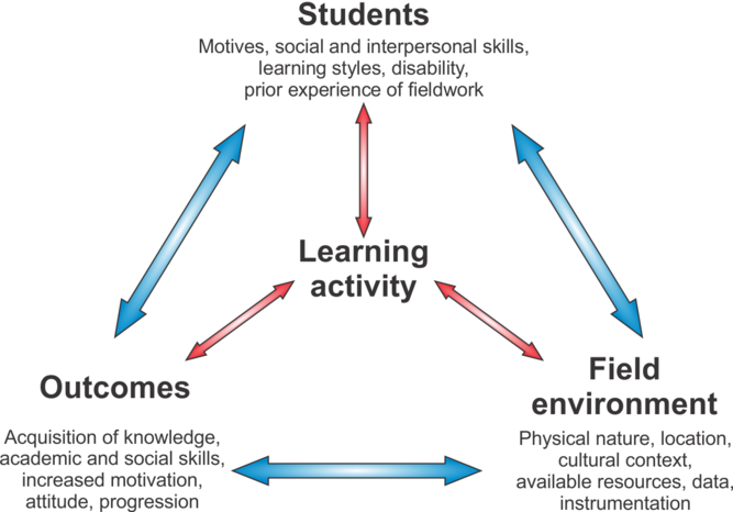
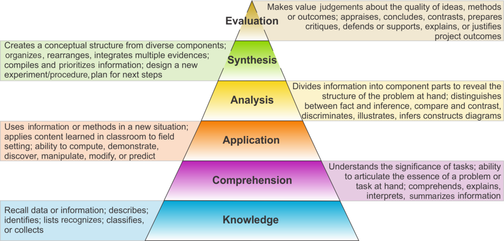
Designing an effective field trip requires a clear understanding of the desired learning outcome (Fig. 1). Accordingly, as proposed by Boyle (Reference Boyle2007), the learning goals must be aligned with the physical context where activities are run (i.e. geological setting, logistics) and the audience’s prior level of knowledge. Fieldwork planning should take into account the following important elements: (i) the type of activities, where students can directly observe the fundamental principles and concepts of geoscience interacting with the environment (Orion & Hofstein, Reference Orion and Hofstein1994); (ii) the possibility to transfer what has been taught in the classroom or lab to the field and vice versa using Bloom’s taxonomy (Fig. 2; Bloom, Reference Bloom1956); (iii) problem-based exercise strictly related to the geological context; (iv) students being stimulated to develop ‘scientific habits in mind’ (AAAS, 1989); and (v) skill mastery such as observation and descriptive skills (e.g. lithology, morphology structures), procedural skills (e.g. geolocalization, navigation point-to-point, annotation), measurement skills (e.g. strike and dip, sedimentary log, structural data), and ancillary skills such as writing, quantitative skills and graphing (Mogk, Reference Mogk, Miller, Hudak, Wittkop and McLaughlin2011). In this context, particular emphasis needs to be given to removing any potential limitation that could exclude or limit the experience for students with disabilities. Disabilities can cover a wide spectrum of cases, from physical to mental, which need to be carefully assessed. In order to do this, it is important to move from a medical perception of disability to a social one that can identify and remove, through strategic planning, barriers to wide participation (Healey et al. Reference Healey, Roberts, Jenkins and Leach2002). For a long time, most geoscience education programmes have not designed an inclusive environment for every participant and it is important to make up for lost time.
Model of learning activities for fieldwork (after Maskall & Stokes, Reference Maskall and Stokes2008).
Pyramidal representation of Bloom’s taxonomy of cognitive skills with examples of applications to learning in the field (after Mogk, Reference Mogk, Miller, Hudak, Wittkop and McLaughlin2011).
3. Disability and fieldwork
Disabled students form a sizeable and significant minority of higher education students (Hall et al. Reference Hall, Healey and Harrison2002; Riddell & Weedon, Reference Riddell and Weedon2014; US Department of Education, 2020). For example, data presented by the UK Higher Education Statistics Agency (HESA, 2018) show an increase from 9 % to 12 % of higher education students with disabilities in the period 2012/13–2016/17.
Research studies have pointed out that certain disciplines are more ‘closed’ to students with disabilities than others. In particular, results show that numbers of students with disabilities in higher education are high for social and legal sciences and humanities, and low in geoscience disciplines because of real or perceived physical barriers (Poussu-Olli, Reference Poussu-Olli1999). As a result, although much effort has been made to reduce the barriers and accommodate different types of disabilities (Seale, Reference Seale2013), inclusivity is still challenged when it comes to fieldwork experiences (Hall et al. Reference Hall, Healey and Harrison2002; Atchison & Gilley, Reference Atchison and Gilley2015; Chiarella, Reference Chiarella2019; Stokes et al. Reference Stokes, Feig, Atchison and Gilley2019). In recent years, the International Association for Geoscience Diversity (IAGD) has worked to foster inclusion and accessibility for people with disabilities, organize accessible field trips and promote field trip practices (https://theiagd.org/), but the whole geoscience community needs to commit and actively contribute. In this context, it is also important to note that although there is a vast literature on the experience of disabled students in higher education, only few publications acknowledge the difficulties that disabled students face during fieldwork experiences (e.g. Hall et al. Reference Hall, Healey and Harrison2002; Atchison, Reference Atchison2013; Gilley et al. Reference Gilley, Atchison, Feig and Stokes2015; Stokes et al. Reference Stokes, Feig, Atchison and Gilley2019; Giles et al. Reference Giles, Jackson and Stephen2020).
3.1. Fieldwork design and preparation
Fieldwork can represent a barrier for certain students due to the inaccessible nature of some field sites or the impact on mental health. In addition, there may be reluctance from organizers, due to increased insurance costs (Atchison & Feig, Reference Atchison and Feig2011), or in instances where students must pay for field trips there are financial restrictions that might limit students’ ability to take part. This could result in a group of students being left out of the whole or a particular part of the trip (Hall et al. Reference Hall, Healey and Harrison2002). Accordingly, the challenge facing higher education programmes requiring fieldwork activities is to develop solutions that do not rely on the assumption of able-bodiedness among students (Hall et al. Reference Hall, Healey and Harrison2002).
In order to face the difficulties related to the organization of a barrier-free field, two approaches have been used, responsive and enabling (Hall et al. Reference Hall, Healey and Harrison2002). A responsive approach provides solutions when a situation or problem becomes apparent (Baron et al. Reference Baron, Philips and Stalker1996). The enabling approach is more radical and forecasts the possible limitations that disabled students can face during fieldwork, and puts into practice all possible actions in order to overcome barriers. To optimize the results and compensate for our potential lack of perspective, input from students is fundamental because no one understands the abilities and limits of the participants better than the participants themselves (Atchison & Gilley, Reference Atchison and Gilley2015). Accordingly, the best strategy to remove any potential barrier and limit the use of a responsive approach is to identify via site survey, field activities design and risk assessment any potential events that may have a negative physical or mental impact. This process can be improved if conducted in collaboration with one or more student or staff members affected by disabilities. For detailed recommendations on how to design an inclusive and accessible field trip, works published by several authors (e.g. Atchison & Gilley, Reference Atchison and Gilley2015; Gilley et al. Reference Gilley, Atchison, Feig and Stokes2015; Stokes & Atchison, Reference Stokes and Atchison2015; Hendricks et al., Reference Hendricks, Atchison and Feig2017; Atchison et al., Reference Atchison, Parker, Riggs, Semken, Whitmeyer and Pearthree2019; Feig et al. Reference Feig, Atchison, Stokes and Gilley2019; Stokes et al. Reference Stokes, Feig, Atchison and Gilley2019) provide valid and successfully tested guidelines, based on input coming from participants in fieldwork, specifically designed for people with disabilities. Important to highlight is that responsive approaches are not necessarily less effective at including disabled students than enabling approaches, and that field trip leaders and university management need to be aware that ‘it is unlikely that all eventualities can ever be foreseen and planned for’ (Hall et al. Reference Hall, Healey and Harrison2002).
4. Potential solutions (and their limitations) for an inclusive field experience
Working with disabled students involves a completely different perception of teaching and fieldwork. The general assumption in the geoscience community is that every student would love to be in the field, but we need to recognize that this is not always the case and that some individuals may struggle (John & Khan, Reference John and Khan2018; Stokes et al. Reference Stokes, Feig, Atchison and Gilley2019). Physical disabilities can limit movement and prevent students from reaching a specific location or keeping the pace of the group. Moreover, during a field trip, students are typically much more stimulated to have discussions about possible interpretations of the studied outcrops, creating a situation that can be particularly stressful for students with communication difficulties (e.g. anxiety). Accordingly, specific actions can be considered in order to remove, or at least reduce, the limiting and stressful impact that fieldwork activities could generate. The best way to foster inclusion and remove the fieldwork barriers is through the design of inclusive fieldwork with valuable experiences for all participants, not just those with disabilities (Stokes et al. Reference Stokes, Feig, Atchison and Gilley2019). Several studies have tested and suggested actions that can foster inclusion (see below). However, in order to maximize their value, a dedicated evaluation and design of the field trip reflecting the needs of the field trip participants is recommended. This is because what might work for one cohort might not necessarily work for another.
(i) High-resolution 3D digital models are becoming increasingly common datasets used in research and education (Berra et al. Reference Berra, Felletti and Zucali2014; Buckley et al. Reference Buckley, Ringdal, Naumann, Dolva, Kurz, Howell and Dewez2019; Nesbit et al. Reference Nesbit, Boulding, Hugenholtz, Durkin and Hubbard2020). The digital model most used in the geosciences, and the one which provides a closer experience to being in the field, is the virtual outcrop potentially enriched by the use of virtual glass in an augmented reality (Fig. 3a, b) – educational tools built around digital outcrop that are currently seeing a growing application in response to travel restrictions related to the Covid-19 pandemic. The global pandemic has forced academics to develop alternative solutions which use virtual outcrops or software (e.g. Google Earth or Apple Maps) to replace field trips with virtual experiences, a strong and common effort that might indirectly benefit students with disabilities as well. Digital outcrop data and augmented reality can represent a powerful tool to overcome physical barriers encountered by students affected by disabilities. However, there are different views around the use of virtual outcrops as an alternative to traditional fieldwork activities. Mogk & Goodwin (Reference Mogk, Goodwin, Kastens and Manduca2012) argue that some cognitive and affective gains can only be acquired through immersive field experiences that cannot be replicated though virtual fieldwork. An additional important aspect to be considered is sickness (e.g. headache, nausea, disorientation, etc.) related to a long exposure to a virtual environment (Barrett, Reference Barrett2004). On the other hand, some see virtual outcrops as a valuable alternative that can even increase the experience of the whole cohort compared to what people would obtain from traditional fieldwork (Buckley et al. Reference Buckley, Naumann, Ringdal, Dolva, Tong, Vanbiervliet, Kurz and Howell2018). Although there are pros and cons, virtual outcrops can be valuable when used in combination with traditional field activities, particularly during the pre-field-trip phases to prepare the students for the environmental and logistic situations to which they will be exposed. Moreover, giving the students the possibility to assess the locations that will be visited allows them to provide comments and highlight any perceived stress factor or barrier – comments that can be collected in a dedicated box to preserve anonymity. Accordingly, perception of traditional fieldwork experiences versus virtual field trips suggests that virtual field trips are overall seen as valuable learning activities, although they cannot replace the social experience involved in any outdoor activity (Fuller et al. Reference Fuller, Georgeson, Healey, Hurst, Kelly, Riddell, Roberts and Weedon2009).
Examples of useful practice to foster inclusion. (a) Virtual outcrop model of Gerace Hill (Siderno Strait, Calabrian Arc, Italy) generated from drone and terrestrial LiDAR data acquired during the FORCE SAFARI project. (b) Example of augmented reality applied to artificial exposures (e.g. mines) (credit: http://holo.group/en/geology/). (c) 3D tactile map of the Central Mediterranean Sea highlighting geomorphological features. (d) 3D model of the Book Cliffs (Utah, USA) produced from a virtual outcrop (2nd Virtual Geoscience Conference, Bergen).

(ii) An easy action to foster inclusion is providing the field guide in different formats (e.g. printed and audio) (Stokes et al. Reference Stokes, Feig, Atchison and Gilley2019). If printed field guides represent the typical learning support in field activities, audio guides still have a very limited application in academic field trips. Audio guides can be fundamental in providing accessibility for students with visual impairments or with specific learning disabilities since having an audio description of the stops can improve their field experience. This technique is normally used in museums and heritage sites, receiving positive feedback from visually impaired attendees. Moreover, in order to reduce the difficulties for mobility-impaired students, especially when it is not possible to arrange multiple means of access to locations, the use of real-time telepresence (e.g. audio or video streaming) and audio field guides allows students to observe the described structures and interact with the rest of the group even if they are located in a safer area. Not least, access to audio guides allows students with visual and reading difficulties to benefit from the supportive learning material without disclosing their impairment. For example, a teacher’s microphone could be directly connected to students’ headsets and hearing aids via Bluetooth technology to aid their ability to hear while in the field. This is a solution that could be beneficial for all students, particularly in high-wind areas.
(iii) Sign-language interpreters can also support field activities to help students with limited hearing. In this case, it is important to consider the presence of international students potentially trained in different sign languages and the difficulties related to a specific geoscience terminology. To overcome this problem, the Scottish Sensory Centre at the University of Edinburgh (www.ssc.education.ed.ac.uk/bsl/) has developed in the last few years a British Sign Language Glossary focusing on scientific terminology for STEM disciplines (Meara et al. Reference Meara, Cameron, Quinn and O’Neill2016).
(iv) Tactile maps can represent a valid support to help perceive different lithologies and geological structures (e.g. faults, folds, channels) using materials such as fabric, various grades of sandpaper and puff-paint (Atchison & Gilley, Reference Atchison and Gilley2015), and topography or bathymetry (Fig. 3c). However, it has been acknowledged that the 3D tactile maps currently available have generally lower geographic coverage than traditional maps, so trip leaders’ inventiveness and bricolage ability to build handmade 3D maps could be required (see Atchison & Gilley, Reference Atchison and Gilley2015). Although still in the early adopter stage, 3D printers, computer-numerical-control (CNC) mills and/or laser cutters can be used to create bespoke maps and models from virtual outcrops (Fig. 3d).
Finally, (v) reduction in the number of stops can limit the physical stress of getting on and off the bus. This will also give the possibility to stay longer in each location, giving students sufficient time to fully engage with the learning activities regardless of their impairment (Stokes et al. Reference Stokes, Feig, Atchison and Gilley2019).
Recent studies (e.g. Stokes et al. Reference Stokes, Feig, Atchison and Gilley2019 and references therein) have shown that it is possible to foster accessibility to fieldwork, and that students with disabilities can participate in activities and discussion if accessible conditions are created. Although much has been done in recent years to reduce physical and non-physical barriers, there are still many areas where we need to work to improve inclusion. Areas to be investigated are the extension of 3D map coverage and quality improvement of existing, typically low-resolution maps; use of audio field guides; and implementation by academic departments in the teaching programmes of inclusive field trips. Moreover, Stokes et al. (Reference Stokes, Feig, Atchison and Gilley2019) emphasise that the focus areas where we need to work in designing inclusive field trips (i.e. multisensory engagement, pace, flexibility of access and delivery, and a focus on shared tasks) are the same ones representing the core of a successful field trip in general. This means that ascribing the correct value to important field trip aspects results in a massive improvement in inclusion. Accordingly, learned societies can play an important role in promoting the culture of inclusivity as normal practice throughout academic programmes.
Conclusions
Disability can represent a limitation for students interested in higher education programmes traditionally characterized by a large component of fieldwork activities. Although several studies highlight that students with disabilities tend to avoid such courses, data show that a considerable number of them end up being enrolled in field-related geoscience disciplines. Accordingly, field courses can pose significant barriers to inclusivity which should be addressed at the planning stage. This should not be considered a limiting factor, because redesigning a field course to increase its inclusivity can result in an improved learning experience for all students and instructors.
We as a teaching community are responsible for enhancing inclusion and providing the same opportunities to everyone interested to learn. In particular, as members of the STEM community we have many problems to face in the coming years to foster inclusion at different levels and under different aspects. Now, it is time to start to put actions in place and show that our wishes are actively transferred into our daily work.
Acknowledgements
D.C. would like to thank the Educational Development team delivering the CAPITAL programme at Royal Holloway, University of London. G.V. would like to thank the Special Educational Needs Department (SEND) at St Paul’s Catholic College (Sunbury-on-Thames, UK) for valuable discussions. Thanks to the SAFARI team for the acquisition of the virtual outcrop showed in Fig. 3 and for giving access to LIME software. We are especially grateful to Lloyd White and an anonymous reviewer for providing constructive reviews of our paper, and to Peter Clift for his editorial handling. The research is funded and conducted in the framework of the Clastic Sedimentology Investigation research group (Royal Holloway, University of London).


 Open access