

In the summer of 1848, as the expedition led by James Clark Ross (consisting of the ships Enterprise and Investigator) made its way slowly northwards along the west coast of Greenland, the young lieutenant William Browne (1821–71) must have been busy sketching aboard the Enterprise. He would, by now, have had a strong awareness of his abilities as an artist. Already his drawings from naval surveying in the Pacific had been engraved for Edward Belcher’s Narrative of the Voyage of H. M. S. Samarang published that same year.1 It is curious, then, that only three works from Browne’s first expedition to the Arctic are to be easily found in public archives. The sketches with which he returned generated not only Burford’s large panorama but also a folio of ten lithographs and a set of engravings in the Illustrated London News.2
As further proof of his productivity and enthusiasm, we might look to one of the three works that remains: Rough Sketch Moored to an Iceberg (Figure 1.1) is a small work on grey paper that shows two ships in the ice and has three figures in the foreground.3 At first glance, the picture is unimpressive and easily dismissed. However, attending to the details reveals valuable information. At the top of the page, along with the explanatory title, ‘Willy Browne (Lieut) no. 37’ has been hastily written, implying that at this early point in the journey Browne had already produced over thirty drawings. Certainly, this note suggests that many more of his works could be recovered in the future, or that tens of small and apparently insignificant sketches have been discarded over time. We might also observe the very small size of this work (10 × 19 cm) and the limited colour palette of blue, white, black, and brown. Looking again, we notice the stains on the paper, the obvious speed with which the drawing has been executed, and the use of crayon as a practical choice for outdoor drawing. In short, the sketch tells us far more than simply what it illustrates. It contains obvious clues to its origins on the spot, outdoors, in the Arctic, and textual information that hints at the amount of visual material from these expeditions that must have been lost, destroyed, or still lies undiscovered in the attics of Victorian homes.

Such visual archives that remain are often small and fragile, created on paper with pencil, watercolour, crayon, or ink, making them vulnerable to fading, damage, and loss. What remains today can be found catalogued in archives, hidden between the leaves of journals, or in substantial sketchbooks. The works from the Franklin search expeditions are, without exception, by amateur artists, who often drew in addition to their duties on board ship, using minimal, rudimentary materials. The works are frequently unsigned, indicating that their makers had no pretensions towards ‘art’.4
Considering the attention given to Franklin’s final Arctic expedition by present-day media, popular authors, and academic critics, very little scholarly research has been done on the primary visual records of the search expeditions that followed in Franklin’s wake. Although academic work has discussed the Arctic imaginary that evolved from this fateful voyage, what has been done on the visual culture attends chiefly to the public face of the Arctic in the mid-nineteenth century: the engravings, lithographs, exhibitions, and professional artworks.5 These public representations are often quite different in style and content from the hundreds of unpublished documentary drawings and paintings by expedition members that exist in archives scattered across the world. The unpublished visual records have, in general, not been studied to any great extent by art historians, who traditionally focus on the more established canon, and both historians and literature scholars are, understandably, more attentive to the written record.
In an article on nineteenth-century naval topographical drawings in the Pacific from an art historical vantage point, Geoff Quilley notes that his own study was ‘richly suggestive of the potential significance of the wealth of similar material that lies, generally disregarded or overlooked, in archives and repositories around the world, and which now needs scholarly attention’.6 The visual records of the Arctic search expeditions are also significant in the way in which they capture responses to the environment and how they reveal a different Arctic to that which was presented to the public. More recently, Felix Driver has noted that, in the context of the history of geography and exploration, the ‘practice of drawing has received some attention though arguably rather less than it deserves’.7
All officers on naval expeditions, midshipmen in particular, were expected to make charts and coastal profiles for navigational purposes: ‘the ability to render in graphic form the dimensions, detail and colour of coastal landscapes was … an essential aspect of the surveyor’s task’.8 They required the skills, techniques, and materials to produce accurate topographical drawings, sometimes gaining the knowledge by training at the naval college in Greenwich but often acquiring the skill set aboard ship. Ships’ surgeons too were expected to be able to record visual information as part of their contribution to the study of natural history. As Nanna Katrine Lüders Kaalund notes, the Franklin search allowed for the development of ‘“opportunistic” science’ in the Arctic.9 However, science and navigation were far from being the only motivations behind the pictures drawn by members of expeditions. In many instances, men were clearly drawing for their own personal reasons rather than by any compulsion to fulfil their duties aboard a vessel. Neither were officers the only ones who drew and painted; evidence exists in the archive that visual recording was practised among all ranks of a ship’s company.
This chapter aims to uncover some of the richness of the on-board visual records, while showing what further information can be gleaned from these lesser-known works. Officers who created drawings to advance knowledge attempted to give ‘objective’ renderings of what they observed, yet these pictures could have subjective overtones, and on occasion there were underlying expectations that they would be aesthetically pleasing. However, in addition to the creation of scientific drawings for geographical and navigational purposes, the desire to have personal visual souvenirs to serve as nostalgic reminders of places, and even people, encountered on a voyage provided an equally strong impulse to draw. Some of these drawings eschewed any scientific intent, aligning themselves rather with subjective experiences in the Arctic, and yet could still inadvertently contain scientific information. In this way, the objective and subjective permeate each other and can be seen to merge in some of the works. In many cases, inscriptions and other forms of paratext (inscribed frames, for example), or the lack thereof, reveal the artist’s intentions and the projected future purpose of the record. Furthermore, the primary visual corpus examined confirms that summer views (when on-the-spot work was most feasible) dominate the archive, contrary to the popular imaginary of a region covered in ice and snow.
Although the argument that nineteenth-century British explorers in the Arctic were overly influenced by the aesthetic categories of the picturesque and the sublime is a popular one,10 an examination of the archival material does not show that the picturesque or the sublime dominated representations of the region, although expedition members probably had an awareness of such categories. Significantly, we should also note that, in the library of the Assistance during the Belcher search expedition from 1852 to 1854, there were no books by William Gilpin, Edmund Burke, Uvedale Price, or any other writers on aesthetics, out of a collection of almost seven hundred volumes, in which science, geography, and history dominated.11
The archive of expedition members’ visual records is scattered; from Canada to Britain to Australia, the dispersal of the records suggests that not all material was handed over to the Admiralty on the expeditions’ return or that some material was returned to expedition members.12 Some of the visual material existed in private collections and subsequently found its way to local and national archives; it is conceivable that still more lies buried in family homes worldwide. Thus, we must be mindful that the work viewed during the course of this research represents only a portion of an incomplete and fragmented visual register. The fragile nature of the works by these amateur artists implies that much more material may simply have been disposed of; such small, unsigned works, faded and possibly torn, may appear unimportant and do not lend themselves well to survival. Even so, this study found over five hundred sketches, drawings, and paintings relatively accessible in archival repositories. In addition, some early photographs survive and are included in the discussion. Only a small portion of the known archive can receive attention here. I have chosen examples by expedition members of all ranks and examined the rhetoric of these pictures to show the nature of the visual culture aboard ship. Some of these pictures are typical of naval topographical drawing, others are unusual, all show that the culture of visual representation aboard ship was powerful and that an examination of these pictures yields a more nuanced view of the life aboard Arctic search vessels. Throughout the book, I refer to similar primary documentary records to make my argument when discussing the visual representation of the Arctic in the mid-nineteenth century.
Drawing as a Scientific Instrument
Hydrography, or making maps for maritime navigation, was a key science on naval expeditions, and technical expertise as a representational artist was valued. Important to navigation in particular was the accurate visual recording of coastlines. Coastal elevations could display geological information if the stratigraphy of the land was accurately drawn.13 However, from the late eighteenth century, the British Admiralty ceased to use professional artists on survey and exploration voyages.14 Hence, the many expeditions that searched for Franklin contained no professional artists; rather, officers, with varying levels of talent, experience, and technical knowledge, were expected to draw for navigational purposes. Such variations are seen in individuals’ choice of materials and methods, handling of perspective, confidence of line or brushstroke, and in their ability to draw human and animal figures (understandably, many naval officers were far more adept at drawing ships and displayed hesitancy in depicting human figures). As Felix Driver points out, drawing was a way in which a midshipman or officer could distinguish himself and perhaps gain a promotion. Carefully produced drawings could impress superiors at a time when there was intense competition for naval posts.15 Notwithstanding the possibility of a promotion, many on board were drawing for other, less career-motivated, reasons – to create mementos of their experiences, to pass time during the winter, or to record their subjective response to the environment.
The library catalogue printed on board the Assistance in 1853, during the Belcher expedition from 1852 to 1854, lists only two titles on painting techniques (‘Painting Water Colors’ and ‘Painters Art. Fields, Rudiments of’)16 out of an estimated collection of 680 books.17 There were also two books on photography, reflecting an interest in adopting the new techniques of visual recording (‘Photography’ and ‘Photography Thornwaits [sic], Guide to’).18 The largest portion of the library, over a quarter, consisted of works pertaining to Geography (including travel narratives that contained illustrations).19 Although there were no books listed that dealt explicitly with the aesthetics of the sublime or the picturesque, the library on the Assistance did contain volumes of Alexander von Humboldt’s recently translated Cosmos, which included his essay ‘Landscape Painting’.20 Humboldt’s essay asserted the link between science, art, and poetry, arguing that ‘an ancient and deeply-seated bond’ united ‘natural knowledge with poetry and with artistic feeling’.21 Science was closely tied to landscape painting in its representation of the ‘characteristic physiognomy of different positions of the earth’s surface’.22 Nigel Leask comments that Humboldt regarded ‘aesthetic and emotional responses to natural phenomena’ as additional data. Although Leask draws a contrast between this approach and the ‘rigorous exclusion’ of those responses ‘from contemporary practices of naval and military surveying’,23 certainly during the Franklin search expeditions, personal responses sometimes permeated the officers’ scientific work that was intended to add to knowledge. Skills acquired for scientific and navigational recording could also be put to personal use, and the two modes of expression often overlap in the archive, as more private records can still retain scientific information.
Although the primary object of the searches was to find the Franklin expedition and render assistance, the officers on the voyages were expected to accumulate information for the advancement of science. Trevor Levere notes that the principal arguments for the exploration of the Arctic at this time were scientific rather than commercial, and Andrew Lambert draws attention to the hugely influential role of Edward Sabine (a founder member of the Royal Geographical Society (RGS) and later General Secretary of the British Association for the Advancement of Science (BAAS)) in encouraging expeditions searching for Franklin to collect scientific data, particularly in relation to geomagnetism and navigation.24 Science became increasingly visual during the nineteenth century, as prints were more available to the public and spectacles like the panorama, which sought to give ‘an intoxicating God’s eye view’ of a scene to observers, were popular forms of entertainment as well as education.25 A ‘craving for visual images’ was a characteristic of mass culture in the latter half of the nineteenth century.26
Although topographical draughtsmen were not in the same class as professional artists,27 the painting of landscapes became both popular and diverse in Britain during the late eighteenth and early nineteenth centuries. As Luciana Martins notes, this period saw both the classical ideals of landscape and picturesque taste confronted by a new naturalism in landscape painting.28 This new naturalism was accompanied by an interest in natural science and in understanding nature.29 Furthermore, landscape, and the artist’s response to it, was seen to be capable of representing ideas and events, emotions and individuality. The idea of fusing scientific observation with subjective feeling was a combination that became influential in the development of landscape painting during the nineteenth century.30 The boundaries between aesthetics and natural science became more fluid in practices of visual representation.31
The Admiralty Manual of Scientific Enquiry was published in 1849, as the Franklin searches were gaining momentum, and it gave officers a summary of expectations in the various fields of science; Erika Behrisch Elce notes that 429 copies of the first edition went directly to the Admiralty.32 The library catalogue of the Assistance in 1853 listed three copies of the manual.33 It was intended specifically for the use of ‘Officers in Her Majesty’s Navy’ as well as for ‘Travellers in General’ and was designed to provide basic guidelines in the natural sciences so that travellers could collect information useful to science.34 Naval officers were expected to take accurate observations and report their findings but were not expected to produce theoretical findings.35 The Memorandum at the beginning of the text states the Admiralty’s aims in commissioning the book:
It is the opinion of the Lords Commissioners of the Admiralty that it would be to the honour and advantage of the Navy, and conduce to the general interests of Science, if new facilities and encouragement were given to the collection of information upon scientific subjects by the officers, and more particularly by the medical officers, of Her Majesty’s Navy, when upon foreign service.36
Chapter by chapter, it deals with Astronomy, Magnetism, Hydrography, Tides, Geography, Geology, Earthquakes, Mineralogy, Meteorology, Atmospheric Waves, Zoology, Botany, Ethnology (an emergent discipline at the time), Medicine, and Statistics. The ability to be an accurate draughtsperson – something that required time, experience, acute observation skills, and concentration – was tied in closely with the practice of scientific observation and investigation. Although it did not appear to warrant its own chapter, draughtsmanship is referred to repeatedly throughout the manual. Drawing, both as an interpretational tool and as part of the recording process, is recommended over a lengthy verbal description. Charles Darwin, who wrote the chapter on Geology, recommended a book by the natural historian Louis Agassiz on glaciers, ‘with its admirable plates’, to anyone going to the polar regions.37 The plates in Agassiz’s Études sur les Glaciers (1840), drawn by Agassiz’s artists and printed on his own lithographic press, are detailed and scientific, yet also display an artistic understanding of composition and a delicate treatment of line, showing how geology drew art and science together in its depiction of the environment.38 The implication here is that other artists should aspire to depict the landscape as elegantly, clearly, and accurately as in those plates. The chapter on Geography by William J. Hamilton recommends that
slight sketches of the country, and of the peculiar forms of hills, however hastily and roughly made, will be of more assistance in recalling to his own mind, or in making intelligible to others, the features of the district he has visited, than long and elaborate descriptions. Let him then acquire the habit of never quitting his ship without his note-book and pencil and his pocket-compass.39
Here, Hamilton recognises the power of memory triggered by the sight of a sketch that assists in the recollection of topography. Such sketches, by their making, inscribe features of the landscape on the mind of the maker. The role of science and geography in encouraging engagement with the landscape and providing the skills and materials for visual expression is important. However, expedition members’ interest in and knowledge of science in general must have varied greatly. Regarding the experiments in magnetic variation on the Investigator in 1848, Samuel Gurney Cresswell, appointed as a mate, wrote to his parents: ‘The scientific men have been making no end of observations, a whole lot of dodges to find the dip of the needle &c. I not being a scientificer do not understand much about it.’40
The scientific rigour with which some expedition members approached their work is evident in the many drawings that exist in the Admiralty archives. In the case of the clerk James J. Rutter, aboard the North Star from 1849 to 1850, his visual work shows that he too aspired to representational accuracy even though drawing was not strictly part of his duties. The Admiralty instructions regarding visual records given to Master James Saunders on the North Star, which was intended to re-supply the Ross expedition of 1848, indicate the information required from topographical sketches of the ‘adjacent shore’, which needed bearings and the ‘latitude of some point … determined, when practicable, by artificial horizon, on shore’. Longitude needed to be established by ‘careful chronometric observations, or equal altitudes’.41
The master’s assistant, John F. R. Aylen, had the responsibility of drawing maps and coastal profiles, but Rutter seems to have taken on the task of drawing ‘views’ of the surrounding environment. All of the surviving work by Rutter and Aylen is dated between June and September, strongly suggesting their work was undertaken outdoors and on the spot. The North Star was unable to locate either of the Ross ships and spent an unplanned winter in Wolstenholme Sound, north-west Greenland from October 1849 to July 1850.42 A View of the Three Glaciers at the Eastern Extremity of Wolstenholme Sound is torn and inscribed with the words ‘sketched and drawn from nature’.43
The watercolour painting, measuring 22.2 × 35 cm, shows an icescape easily identifiable on modern maps. The panoramic layout facilitates the depiction of an area with a span of about twenty-five kilometres of the horizon. The features shown in Rutter’s work – ravines, glaciers, valleys, and hills – are clearly locatable on modern maps, as is the hill of Akínârssuk from where Rutter probably took his initial sketch. The accuracy of the topography is startling, and his attention to detail is evident. Although the title of the picture (‘A View’) and its inscribed frame, as well as its lack of bearings, suggest its maker’s desire for it to be seen as a piece of art, scientific and topographical accuracy take precedence here. The picture appeals neither to the picturesque nor the sublime. Although the foreground could be said to lead the eye towards the largest glacier, a lack of novelty negates the picturesque, while the blue skies counteract any sublimity that the vastness of the ice might have suggested.
Furthermore, the picture holds relevance for modern glaciology and climate change. Taking measurements from modern maps, we can see that the glaciers have retreated significantly since Rutter’s eyewitness account, with the largest glacier, Harald Moltke Brae (Sermersuak), having retreated roughly eight kilometres from its face since 1850. This clearly shows the potential of appropriate nineteenth-century visual records to be used in the accumulation of historical data to extend glaciological records further back into the past. The precision of the painting indicates that naval personnel were expected to take topographically accurate drawings and did so, to the best of their abilities. The blue skies and benign weather conditions evident in the picture would have enabled it to be executed with a high level of detail.
While a clerk like Rutter would not have been expected to make drawings as part of his job, he did receive lavish praise in Saunders’s report, for his ‘zealous and active part’ in the expedition and was strongly recommended for promotion.44 Higher-ranked officers, such as those leading sledge journeys in the spring of 1851 as part of the Austin voyage, were explicitly instructed to keep visual records. Spring and its lengthening days brought preparations for sledge-travelling to search for signs of Franklin and to record unexplored coastlines. Officers were expected to make measured topographical drawings on these journeys and did so with varying degrees of success. Temperatures in spring in the Arctic could, of course, be harsh, but it was occasionally above freezing. Cold affects motor skills such as finger and manual dexterity negatively,45 and combining the rigours of sledge travel with the delicate act of drawing cannot have been easy.46 Away from the ship, the transportation and care of fragile paper drawings must have been difficult.
In the spring of 1851, Horatio Austin gave clear instructions for his officers to draw while on these journeys: ‘You are expected to make all sketches of headlands &c. that you can; and are referred to the “Admiralty Manual of Scientific Inquiry”, in order that you may make such observations and collections as may prove useful.’47 On this occasion, however, Lieutenant William Henry Browne was given more specific instructions, prior to his sledge journey along the unexplored east coast of Prince of Wales Island, which reminded the lieutenant of his particular responsibility:
Although observations and drawings are wholly secondary to the great work you are about to aid in carrying out, yet I feel it my duty to remind you here, that the approval of your appointment to the ‘Resolute’ was given in full anticipation that, if opportunity presented itself, the Government and science at large would receive from your acquirements and intelligence a considerable addition to what is already known of these regions.48
The singling out of Browne adds an extra burden to his duties, as Austin seems to assign him the role of expedition artist. Austin stresses the importance of adding to knowledge through drawing. The ‘opportunity’ he refers to is that Browne is about to travel along an unexplored stretch of coastline. In his instructions, Austin makes his assertion that Browne should justify his appointment to the Resolute by demonstrating his known talent as an artist. The expectation that he would produce extensive high-quality visual records may have underpinned the Admiralty’s hopes.
In fact, Browne’s sledge report included no drawings (apart from a map), unlike those of his contemporaries, George Frederick McDougall, Walter William May, and Robert Dawes Aldrich, who may have wanted to prove their artistic talent and perhaps achieve some of the fame enjoyed by Browne after the previous expedition. Browne, when he handed in his sledge report, included this note explaining his lack of drawings:
P.S.-I have much regret that the sameness in the appearance of the land has not afforded me that opportunity of using my pencil which I so earnestly desired and indeed expected, for, with the exception of a view of ‘Cape Walker’ and No. 1 Cape, I have no illustrations worth notice. These, should they prove fit for finished drawings, will be forwarded when completed, and the angles, &c. when copied.49
As Browne discovered, the topography of the Canadian Arctic archipelago lowers in elevation the further one travels west from Baffin Bay to the Beaufort Sea, and the Austin expedition, which was further westward, was not exposed to the same dramatic scenery that he had encountered during his first Arctic winter. That the landscape, to his eye, did not provide enough variation to be worth recording as he had ‘so earnestly desired’ and ‘expected’ strongly implies an awareness that – following the success of lithographs and a panorama based on drawings from his previous Arctic expedition – his visual records should now appeal to a wider general audience. As Martin Rudwick points out, this was an audience with a heightened awareness of visual culture and an interest in ‘“romantic” subjects such as mountain scenery’.50 Browne’s excuse also reminds us that these officer-artists were not professional artists with any degree of autonomy but were working under Admiralty orders. Furthermore, the note confirms that drawings could be begun in the field and finished aboard ship, once enough information in the form of a visual sketch with navigational information had been taken.
Browne’s surviving work from the Austin expedition (1850–1) shows that he had a good knowledge of geology, which he was able to blend with his artistic talent without sacrificing topographical detail. It was this artistic skill, as well as a real feeling for the landscape, that produced art that could be easily translated into commodities, from lithographs for a scientific audience to a panorama for the average urban dweller. Cape Walker Encampment (Figure 1.2) displays his convincing rendering of the sandstone cliffs on Somerset Island with the whole landscape handled with a certain softness that displays subjectivity within science.51 It is more than a topographical record; it is a response to the landscape. His accurate description in his sledge journal shows his geological knowledge: ‘The cape [Cape Walker] itself is a high cliff, or rather a series of cliffs, running in a N.W. and S.E. direction, but the highest part or cape, I think, faces N.E. The cliffs are composed of red sandstone, with masses of conglomerate, and veins of dark-looking substance, like bad coal.’52

Although the sea cliffs, large and imposing yet almost decorative with their cascading snow, suggest both the sublime and the picturesque, Browne is still fulfilling a scientific role. An interest in the subjective response to the environment did not preclude scientific accuracy; indeed, the coexistence of science and aesthetics in both scientific and literary tracts was common until the late nineteenth century.53 The twentieth-century geologist and artist Maurice Haycock (who painted in the same area as Browne) succinctly explains this coalescence of science and art to Barry Lopez in Arctic Dreams: ‘He talked about why one went out to paint like that. It was a conversation with the land, he said.’54 Browne’s ostensibly objective and scientific picture betrays a subjective and romantic presence, a version of the sublime that seems unthreatening, with the soft glow of the sun emanating from the horizon. This sublimity is unlike the Burkean sublime represented in many of the published representations during the latter years of the search, and seems to reach back to that earlier, more contemplative sublime. Furthermore, the presence of tents provides a scale but also points to the sledge party’s place in the environment. These are not tourists in search of landscape views, excluded from their surroundings; these are the tents of expedition members, working, living, and sleeping in the environment.
If pictures were drawn in order to add to knowledge, they could also be undertaken for professional reasons that might not necessarily be strictly scientific in nature. The North Star, intended to supply the Ross expedition in 1849, was given explicit instructions by the Admiralty not to winter in the Arctic that year. However, the ship became trapped in the ice off the north-west coast of Greenland and was forced to disobey orders. An annotated drawing exists that may be the captain’s visual evidence needed to vindicate himself. Aylen’s Perilous Position of HMS North Star, which is clearly signed and dated, appears at first glance to be a striking example of an on-the-spot sketch.55 The large drawing, 30.8 × 59 cm, was folded into a rough square shape 15.5 cm in width. One might be tempted to think that this was for ease of transport back to the ship from the height where Aylen recorded the scene. The grubby, stained nature of the paper, as well as the deep creases and faint pencil marks, also suggest its origins in the Arctic itself, bringing with it the elements of nature that surrounded Aylen as he drew.
However, when this piece is cross-referenced with textual evidence in the form of Saunders’s report on the voyage, it is hard to see how Aylen could have risked disembarking and travelling so far from the ship to obtain the view under such conditions:
On the 21st of September it blew a strong gale from the eastward, and the ship drifted with the [ice] pack rapidly to the westward, and at about 5 p. m. the ice was opened, in consequence of its coming in contact with an immense berg of some miles in circumference.56
While the elements of the picture, such as the ‘berg aground’, mirror those of the text, it is possible that it was in fact drawn shortly after the event as ‘proof’, or during the event, from a conjectural viewpoint. A corresponding sketch in the British Library entitled Fig. 1 at 6 p. m. Position of HMS North Star, 21st Sept. 1849. Drifting in the Ice towards Berg B in a gale of Wind from SSE depicts a plan-view, or map, of the scene.57 Like the other sketch, the heights of the bergs, 200 feet and 170 feet, are inscribed on the paper. It seems likely that both representations were intended to consolidate Saunders’s report by verifying the incident visually. After all, he had been explicitly instructed to ‘carefully avoid risking all hazard of the “North Star” being detained a winter in that region’.58 The written information, including arrows added in red ink marked ‘about 3’ per hour’ indicating the progress of the drifting berg towards the ship, makes clear the situation. On the right-hand side of the picture, the immense mass is confirmed to be a ‘Berg aground upward of 200 ft High’, while the berg drifting towards the ship ‘Berg Drifting about 3’ per hour’ is 175 ft. The use of the word ‘Perilous’ in the picture’s caption emphasises to the Admiralty the difficulty endured by the ship and the hopelessness of her situation.
The drawing, with its inscription, tells us much about Aylen’s understanding of the landscape in which they found themselves drifting. The significance and worry of the imminent danger present the event as one worthy of visual recording. Here, the aesthetics, and indeed the topography, are unimportant; it is the position of the ship in relation to the sea and ice that matters. The picture functions as a record of the condition of the ice and of the ship confined within that environment.
Personal Records and Expedition Mementos
While it was possible for subjectivity to overlap with technical accuracy at times, there were other visual records created purely for personal use; these too could hold scientific value, and the two types of drawing were not mutually exclusive. The observational skills necessary for, and tools required by, the collection of knowledge also enabled a more subjective and emotional response to the Arctic. As Erika Behrisch argues, ‘the detailed demands of scientific enquiry encouraged a poetic imagination and form of expression’.59 Focusing on three unpublished poems by three different officers, she shows how the act of exploration ‘encouraged an intimacy’ with the Arctic while the Admiralty’s instructions ‘promoted a curiosity that was equally artistic as it was scientific’.60 As Behrisch notes, the scientific and objective recording of observations ‘depended, ironically, upon an engaged sense of place and an active relation with the Arctic landscape’.61 What Behrisch observes in the poetry of expedition members can also be seen in their visual records. The act of drawing the landscape by the observer, situated within the natural surroundings, established an intimacy with the environment. During this period, when photography was still cumbersome and expensive, people ‘took’ sketches in a manner not unlike how we now ‘take’ a photograph. This act is not necessarily always a ‘taking’ or appropriation of the landscape. Although Richard Sha points out that the common use of the phrase ‘to take a sketch’ in the late-eighteenth and early nineteenth centuries associates it with ‘appropriative force’,62 Majid Yar has noted that the gaze is not only connected to power, and other possible aspects include emotional and communicative experiences.63 Indeed, those on the Franklin searches were more likely to use the word ‘make’ than ‘take’ when referring to sketches.64
Drawing, along with reading and keeping a personal diary, was one of the middle-class values central to work and pleasure that transferred to shipboard life and encouraged social cohesion on expeditions.65 While naval officers were expected to produce basic topographical drawings as part of their duties, individuals aboard ship, including non-officers, often created drawings for other reasons, such as to include in a letter, or to make sense of their environment personally and illustrate their journal, to create souvenirs for others or mementos for themselves of people, places, and events for sentimental reasons. In one instance a small vertical painting (12.3 × 3.3 cm) of the ship in winter quarters was created as a bookmark.66
Many of these drawings can be seen as travel sketches, made of ‘places, buildings, objects, people or events seen during a journey; often made to record a particular feature for future reference’.67 Such sketches are sometimes rough drawings, or unfinished paintings, hastily made. For example, the colour sketch (Figure 1.3) done by the surgeon of the Resolute, William T. Domville, on the Belcher expedition shows an unfinished sketch of a spontaneous social event.68 The dance that took place on the Resolute on 8 June 1852, while the ship was anchored at Lievely (Qeqertarsuaq) on the west coast of Greenland, was described by several expedition members in writing, but Domville’s sketch appears to be the only surviving visual record of the occasion.69

The picture shows two Greenlandic women dancing a hornpipe with British seamen while a musician, seen to the left, plays the fiddle.70 The musician, who also played a polka and waltzes according to written sources,71 is partially represented in an incomplete and unfinished sketch. Despite this, close examination reveals that he must have been a Greenlander and not an expedition member, as evidenced by his jacket and trousers. The peaked hood that he wears can be seen in another depiction of Inuit from the same place and time in McDougall’s narrative of that voyage.72 The nationality of the fiddler was not mentioned in any of the written sources and shows us how travel sketches offer additional information. The two women were named as ‘Sophy and Marie’ by McDougall, who praised them for their ‘pretty features’.73 The picture shows a scene at odds with the idea of an Arctic wilderness; instead it appears sociable and domesticated, aspects of shipboard life that will be discussed in Chapter 2. Furthermore, the contact between expedition members and local Greenlanders was prolonged; the dance went on until midnight according to McDougall. Emile de Bray, a French officer on the Resolute, records that he joined officers from the Assistance ‘dancing with the beauties of Lievely’ at the houses when he descended a mountain late that night.74 Another dance was held the following evening, at the house of ‘the fair Sophy’.75
Other members of the expedition were also sketching during this time. James Blair Grove, mate on the Assistance during the Belcher expedition, included a ‘hurried sketch’ of one of the women after this dance on the Resolute in Lievely, Greenland, to send with his letter to John Barrow.76 An extract from this letter and an engraving of the sketch were printed in the Illustrated London News in December of that year.77 At the same time, Robert McCormick, surgeon on the North Star, also travelling as part of the Belcher expedition, wrote to John Barrow, while the ships were at Lievely: ‘I have been busy all day – and have just sketched the Mountain and Danish Settlement for you, according to promise.’78
There is also evidence that expedition members used their drawings and paintings of the Arctic to adorn the interior of the ship or other quarters. Some pictures, worn and battered in the archive, show pinholes at the corners, and references to the crew displaying paintings in their mess exist. Johann Miertsching, interpreter on the McClure expedition, related a visit to the seamen’s mess on the Investigator during New Year’s Day 1851 in his journal: ‘After the muster we went, led by the captain, to the men’s quarters, and were astonished to find a hall elegantly decorated with flags, pictures, sea-paintings.’79 This suggests that the men had painted the pictures themselves, although as the Investigator was abandoned, and the men ordered to take nothing, these paintings are unlikely to survive in the archive. While a small journal could be concealed about one’s person, a larger painting would have been difficult to transport.80 Assistant surgeon Edward Adams, who served on two consecutive Arctic search expeditions, probably hung a small watercolour from his first expedition (led by James Clark Ross from 1848 to 1849) in his room at the Russian trading post of Michaelovski (Taciq), Alaska, during the winter of 1850 to 1851, evincing a desire both to have a memento of that expedition on view and to create a home from his quarters.81
The phenomenon of drawing and painting beyond their official duties is very noticeable on the Austin expedition of 1850 to 1851 in particular, where surviving sketches show that many expedition members were drawing for purposes other than scientific ones. The sensitive and atmospheric watercolours attributed to Robert Dawes Aldrich were not necessary for the advancement of science, nor do they add to geographical knowledge. Despite Aldrich’s role as lieutenant, they do not show a definite location or coastal elevation or give any indication of latitude and longitude. Rather they seem to have been made from an impulse to give visual expression to their voyage. Two small watercolours (13 × 36 cm) show ships, presumably those of the Austin expedition, in full sail on open water.82 The paintings do not appear to be signed or dated in any visible way. The untitled paintings have a panoramic format that lends itself well to the wide horizons visible from the deck of a ship. The watercolours have been created as a pair, one complementing the other, possibly depicting dusk and dawn. The locations represented in the paintings are unknown, but the artist appears to be concerned with using atmospheric light effects to convey a mood rather than with geographical location. They are both mounted on stiff card, and lines from a song, written on card, are glued to the mount.
Both paintings depict summer; the relatively calm weather and apparently ice-free sea suggests a location at the southern end of Baffin Bay, an area known for its pleasant weather at that time of year. It is significant, too, that no ice is represented in these private pictures, for seas choked with icebergs were an essential element of the public depiction of the Arctic. One painting (PAH0072), darker than the other, is accompanied by lines from a song suggesting the time of day. The work may depict midnight in high latitudes near the Arctic (for example, the south of Greenland in early summer). The lines of the song read: ‘Or sailing on the midnight deep / Whilst weary messmates soundly sleep / The careful watch patrols the deck / To guard the “Ship” from foes or wreck.’ These lines are taken from a song, called ‘All’s Well’, by Thomas Dibdin (1771–1841), a duet that appears in several nineteenth-century books of songs.83 The choice of lines from a song to accompany the painting suggests it was a song that was sung on board and shows the interconnectivity of cultural life aboard the search expeditions.84
The second painting (PAH0071) appears to depict dawn at a similar latitude and uses the melancholy lyric of the first verse of ‘Isle of Beauty’, written in the mid-nineteenth century by the popular poet and playwright Thomas Haynes Bayly (1797–1839).85 The lines are: ‘Shades of evening close not o’er us / Leave our lonely, bargue awhile / Morn alas will not restore us / Yonder dear & distant “Isle”.’ While the original lyric, part of a set called Songs to Rosa, seems to speak to a lover and lament their growing old and eventual death, here it seems as though the ‘Isle of Beauty’ is used to express a romantic nostalgia for home. Only the first four lines of the sixteen-line lyric are used here. The lines contain a misspelling ‘bargue’, instead of ‘bark’ or ‘barque’ in the published versions, suggesting that the lines were known by heart rather than copied from a book. Indeed, this song is listed in Reminiscences of the Baltic Fleet (1855) as a ‘Gunroom Stock Song’ in the appendix.86 Some men and officers who served on the Franklin search did go on to participate in the Baltic Fleet fighting against the Russians during the Crimean War (1853–6).
Both watercolours are delicate and sensitive, revealing a confident artist’s hand and an interest in the treatment of light. The paintings suggest the artist’s awareness of the thriving genre of marine painting in Britain, particularly in a romantic sense, where the attention given to nature (the sky and sea) is as important as the ships. It is significant that Aldrich does not portray smoke from the Pioneer and the Intrepid (two steam tenders being used in the Arctic for the first time), preferring to concentrate on the more romantic idea of sailing rather than industrial progress. So too, the accompanying lyrics, if chosen by the artist, betray his romantic sensibilities. The lines suggest a need to express a textual response to the environment, turning to well-known songs to do so. Created as personal souvenirs rather than for scientific interest, the works speak of an expectation of nostalgia for the Arctic voyage in the future.
A third painting by Aldrich (Figure 1.4) depicts a paraselene87 in the background, providing an unusual backdrop for an extraordinary sculpture exhibition.88 The untitled scene, again undated and unsigned, is mounted on card so the reverse side cannot be seen. The snow sculpture of Britannia takes centre stage, while another sculpture of two people is visible to the right, and in the background the four ships of the Austin expedition are apparent against the imposing bulk of Griffith Island.89 Relaxed figures on the ice are scattered among the sculptures, reminding us of the walks and games on the ice that were common when the weather was fine.

Paraselenae were sometimes seen during winter and are represented in first-hand records more often than the better-known aurora borealis, which was elusive in this area of the Arctic in the nineteenth century. The scientific interest of the occurrence, however, is tempered, as the eye is drawn to the sculptures and activity on the ice. Here, the paraselene is being depicted for its beauty, perhaps in addition to its scientific interest. The atmospheric phenomenon creates another kind of impression, a mood of a still and peaceful winter environment.
Although the above pictures are the work of a lieutenant familiar with the requirements of naval draughtsmanship, lower ranks aboard ship also sketched for pleasure, as indicated by Miertsching’s comment on the pictures decorating the crew’s mess. William T. Mumford, carpenter’s mate on the Belcher expedition, drew a series of sketches that were placed between the leaves of his diary. His small pencil sketch of the sight of a new land, The First View of the Coast Greenland (Figure 1.5),90 makes visual his description of the coast as neither a sublime nor a picturesque landscape but as a ‘frieze of broken bottles on a garden wall’,91 a line with no aesthetic or scientific pretensions but that shows his visual interpretation of the mountainous region.
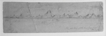
Figure 1.5 William T. Mumford, The First View of the Coast Greenland 21.5.52, 1852. Pencil, 6.7 × 22.7 cm. Library and Archives Canada.
The sketch, delineated by the carpenter, contains none of the scientific information expected for navigation such as bearings, latitude, or longitude. Additionally, the distant view of Greenland’s mountains does not require the use of perspective. This drawing also marks what must be, for Mumford, the real beginning of the adventure, and the lines of the new horizon mark a clear distinction between the country he has left and the region he is about to enter. Mumford’s drawings constitute snapshots on a journey, a record that is personal. Furthermore, the worn and damaged appearance of the paper, its unusual size and shape, as well as the use of pencil (which would be easier to use on board a ship) suggests its origins and life aboard ship, particularly as Mumford had to travel back on the Phoenix when Belcher ordered the abandonment of his four ships after two years in the Arctic.
It is unusual to find much material by non-officers in the archives; as Richard Harding points out, the records of officers are generally better preserved.92 This makes the unique sketch by an able seaman, William Blakey, all the more intriguing. Blakey drew a souvenir of an incident while aboard the supply ship Phoenix in June 1854, under Edward Augustus Inglefield (Figure 1.6).93 The small monochrome sketch has been mounted and framed as an elaborate keepsake. Indeed, the double frame, one around the picture and a larger one encompassing picture and text, not only commemorates the incident but also Blakey’s participation in it and the role of the relief expedition in the overall search.

The main text within the frame reads: ‘The Relief Expedition consisting of Her Majesty’s Ships “Phoenix”, “Talbot” and “Diligence” passing a remarkable Ice Berg in Davis Straits, while proceeding with Provisions and Coal for relieving Sir Edward Belcher’s expedition in the Arctic Seas on the 4 day of June 1854. Height 280 Feet.’ The text on the left-hand side of the picture reads ‘Drawn by W. Blakey. RN’, while the right-hand side bears the inscription ‘In Latitude 67° 50’ North’. It is possible that Blakely was familiar with engravings like The Ice Islands in James Cook’s A Voyage towards the South Pole (1777) and aimed to emulate such works.94
The Arctic environment and positive experiences that took place on expeditions were depicted as responses and as personal souvenirs, particularly for those expeditions that entered the Northwest Passage via the high coastlines of Greenland and the eastern archipelago. But, for the expeditions that wintered in the vicinity of the Bering Strait at the western entrance to the passage, the topography encountered by the ships was less striking than the high mountains and towering icebergs of Baffin Bay. There was also more extensive and prolonged contact with Indigenous peoples due to the nature of settlement along this Alaskan coast, then part of Russian America. Edward Adams, assistant surgeon on Collinson’s Enterprise from 1850 to 1855, drew and painted regularly; his visual work includes thirty-four portraits of Yup’ik, Iñupiat, Gwich’in, Deg Hit’an, Northern Copper Inuit, and Inuvialuit, as well as birds, landscapes, and maritime views. His journal text too is filled with illustrations (on at least twenty-one pages) including drawings of Yup’ik bone carving.95 His most striking painting is that of a young woman, painted in 1851 when Adams was twenty-seven and spent a winter ashore at the Russian fort of Michaelovski in Norton Sound, near the Yup’ik village of Taciq (Figure 1.7).
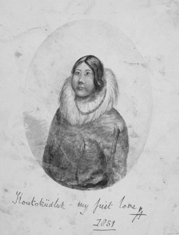
Figure 1.7 Edward Adams, Koutoküdluk – My First Love, 1851. Watercolour, 18.5 × 13.6 cm.
The delicate painting, Koutoküdluk – My First Love, 1851,96 indicates the desire to keep a personal memento of a relationship in the Arctic. The light blue oval-shaped background frames the woman in the absence of an actual gilded frame, commonly used in the 1800s for loved ones, and is intriguing for its use in this context. Significantly, although Adams did other paintings and drawings of people, this is the only surviving picture by him on which such a frame occurs. This painted frame seems to confine the woman in a private space and implies that this was a portrait the artist created expressly so that he could gaze upon it. The size and format of the painting aligns it with the miniature portraits that were popular in the nineteenth century, which were often created as private tokens of affection. As Kristina Huneault points out, titles such as this, where the subject is named ‘convey a sense of specificity quite unusual within the context of colonial representation’.97
Even disregarding the bold inscription and the naming of the subject, the visual format of the portrait betrays the importance of the woman Koutoküdluk to Edward Adams. While the painting has ethnographic details, particularly in its depiction of clothing and adornment, its emotional resonance was clearly of more import for its artist. This is further seen in the blemishes on the paper, which overlay the painting and show that it was handled, and therefore looked at, repeatedly, probably during the remainder of the voyage. This distinguishes it from other portraits by Adams from the same period that are completely unmarked. Although Adams kept a journal from October 1850 to July 1851, his writing reveals little of his personal life, and this woman is not mentioned by name, likely due to the fact that he knew all written records would be read by the Admiralty on their return. However, it becomes obvious when reading the journal that it must have been written after the events took place. This is apparent when he refers to events in the future as though they have already happened. It is possible that an earlier version exists and that Adams created a second version in order to edit Koutoküdluk’s presence out of the text. Neither does he make much reference to his drawing practice in the journal, although the following incident is mentioned when two Iñupiat men travelled to Taciq: ‘the chief refused to allow me to sketch his face, saying it was too ugly, & recommending his friend as a more creditable example of his countrymen’.98 Such a statement shows clear Indigenous agency – people did not always agree to having their portraits taken – as well as signalling that they took an interest in how they were portrayed to those in more southerly latitudes. No engraving or published version of the painting of Koutoküdluk came to light during the research for this book, and by 1856 Adams had died of typhus in Sierra Leone.99
The Unseen Arctic Summer
It is significant that many of the drawings created on board the search ships show an Arctic summer of calm seas and blue skies, yet the overwhelming preconception of the North, then as now, is of coldness and dark, snow and ice. This is despite the fact that not all of the expeditions wintered in the Arctic; many travelled there in early summer to resupply the search ships and returned to England in September. The dominant idea of the Arctic as a desolate and frozen realm, shrouded in mist, was the one chosen more often for representation in the public realm and reinforced the paradigm of a harsh and cold North. Heidi Hansson shows that the ‘cluster of associations surrounding the popular idea’ of the Arctic ‘includes severe cold, distance from civilisation, dangerous conditions, barrenness and exposure to natural forces’.100 She goes on to note ‘winter is the reference point even in works set in summer’ for the ‘(generalized) North’ that is ‘defined through climate and season’.101 Chauncey Loomis argues that, although eighteenth-century writers used the Arctic ‘as a source of mystery, coldness and vastness’, it was not until Samuel Taylor Coleridge’s ‘Rime of the Ancient Mariner’ (1798) that ice became associated with a type of supernatural fear.102 Mary Shelley then used the vastness of Arctic ice to create a polar frame for Frankenstein (1818). That same year saw the beginning of nineteenth-century British Arctic exploration into the then-mysterious regions around the pole and publication of narratives such as William Parry’s Journal of a Voyage for the Discovery of a North-West Passage (1821), which, despite its ‘subdued and accurate’ engravings and understated text, encouraged an accepted romantic image of the Arctic.103 Parry’s expedition had penetrated deep into the Northwest Passage and wintered near Melville Island, far from Inuit settlements. From such accounts, many readers formed imaginings of the Arctic that were a ‘compound of fact and fantasy touched with the power of the Sublime’.104 Caspar David Friedrich’s painting Das Eismeer (1823) showed a nightmarish scene of huge slabs of ice crushing a ship, typifying the Arctic imaginary of the nineteenth century in northern Europe, and the icy wastes again appeared in Ann Radcliffe’s poem ‘The Snow-Fiend’, published in 1826:
A focus on primary documentary visual records from the search expeditions, as opposed to public material such as engravings and lithographs, yields insights into what was represented and what kinds of working methods were used aboard ship and indeed on the ice floe or land. Drawing outside was, as one might expect, practised more in summer, and direct observation from nature was associated with visual testimony, holding the power of ‘truth’ in a way that a report or hearsay could not. ‘On the spot’ is a phrase that became common in illustrated travel narratives from the late eighteenth century, signalling that the landscape was ‘based on observation in the field’.106 The methodological phrase gave authority to the picture; however, the phrase is rarely used on expedition members’ drawings in the context of the Franklin searches, probably because the sketches were not intended for public view and therefore did not need their authenticity verified.107 However, the reality of on-the-spot visual records created in the Arctic might be viewed with scepticism by critics, due to perceived intense cold, darkness, stormy weather, and other factors such as frozen watercolours and the annoyance of mosquitoes in summer. The combined archive of pictures from the Franklin search expeditions suggests a different story. Summer was certainly a time when detailed sketching could be done on the spot with relative ease, with temperatures well above freezing and calm weather often experienced. In June 1848, off the Whale Fish Islands (Imerigsoq) in Greenland, Cresswell, mate on the Investigator as part of the James Clark Ross expedition, wrote in a letter to his parents: ‘The weather is most lovely, quite hot, the thermometer up to nearly sixty and as high as 70 in the sun. We have hardly had a drop of rain since we left England.’108 Moreover, there seemed to be ample time to read and practise drawing: ‘I have taken great pains with my drawing since I have been away … I have read a good deal since I have been away, and have got enough books to last me for years.’109 Adams too, on the same expedition, recorded frequent fine and calm weather in his journal, including ‘perfect’ days when the sea was ‘mirror-like’.110 Such written records of the summer weather are mirrored in the visual evidence provided by the archive. The preference of expedition members for drawing on the spot is reflected in the high number of drawings that are dated between May and September.
Comparatively calm summer weather and often slow progress on sailing ships facilitated drawing, whether a measured topographical view or a travel sketch, on deck. In Baffin Bay during the summer, as expeditions made their way along the west coast of Greenland en route to the Northwest Passage, the sailing vessels often travelled quite slowly due to calm weather or loose ice. Lieutenant Walter William May recorded speeds of one-and-a-half to four miles per hour as the five-ship Belcher expedition made its way along the west coast of Greenland during the summer of 1852.111 On this expedition, travelling as ship’s surgeon of the North Star, Robert McCormick drew hundreds of sketches in his journals and sketchbooks, including coastal views, settlements, and events.112 These rapid pencil sketches were sometimes annotated with written information regarding colour, using text and drawing to record the landscape and indicating that he foresaw the possibility of working them into paintings later. Mumford also created pencil sketches on the voyage (see Figure 1.5) and, later, developed these drawings, mainly of the ships in the Arctic environment, into paintings.113
A visit to Wolstenholme Sound in the north of Greenland by the Assistance and the Intrepid from the Austin expedition in search of the North Star in August 1850 provides unusual evidence of the calm summer weather that can settle in the Arctic and the burst of growth that twenty-four-hour daylight instigates in high latitudes, in this case over 1,000 kilometres north of the Arctic Circle.114 A small watercolour by an unknown hand (Figure 1.8) shows Dundas Hill (Uummannaq) from the sea, clearly viewed from a ship’s deck.115 The torn and stained paper of North Star Mount, with hurried marks, points to the drawing’s origin in the natural environment.

The rise in temperature accounts for the open water and grassy hills, entirely snow-free, in the depiction of North Star Mount by the time these ships arrived.116 The ice-free waters are unusual to see in public depictions yet clearly possible at this time of year. Although the verdant green areas around Baffin Bay were often described in the text of narratives, they were not visually presented to the public, and plates depicting flora were reserved for scientific tracts from expedition naturalists like Berthold Seemann.117 Such a vision certainly did not make its way into the public spectacles of panoramas like Summer and Winter Views of the Polar Regions (1850) (discussed in Chapter 4), which drew the public in large numbers and represented an icy and sublime Arctic that was more in keeping with the polar imaginary inherited from the early nineteenth century.
Representations of ice-free seas are also in evidence in the work of Cresswell on the James Clark Ross voyage of 1848 to 1849. Cresswell appears to have painted in monochrome on this voyage, but as colour versions of some of the paintings exist it may be that he copied the paintings after the voyage. As officers were not professional artists, solely required to make art, they were less likely to bring their own materials on board, perhaps expecting their employer, the Admiralty, to provide the necessary materials to fulfil their duties associated with topographical drawings. Once the voyage had commenced, acquiring the materials to paint or write was an issue, even for officers. Cresswell wrote regretfully to his parents in June 1848, from the Whale Fish Islands, Greenland: ‘I shall not be able to do much painting as I have not got any indigo with me, the most important colour, and the only person in the ship that has is the Asst. Surveyor, but as he has but one cake which will be barely enough for him while we are out, I cannot get a rub.’118
The Arctic summer predominates in his visual records from this voyage, and foliage is in evidence in some of the work. Brown’s Island Aug 1848 (16.5 × 22 cm) shows the land with sparse greenery, and the calm glassy sea in the foreground.119 The ships, tiny and insignificant, rest against a glacial backdrop, but these details take up a far smaller portion of the picture. Adams too, on the Investigator with Cresswell, painted as they sailed northwards, noting in his journal occasionally that mosquitoes were found ashore, but never remarking on them being a problem aboard ship and indeed noting their absence on Brown’s Island.120 Near Upernavik, he did encounter mosquitoes, but also a wide variety of butterflies, an insect wholly at odds with the popular Arctic imaginary and also mentioned by Adams as being found on the Whale Fish Islands.121
The Franklin search expeditions began at a time when photography was being developed, and the most well-known photographs by an expedition member were taken by Edward Augustus Inglefield, who captained the Phoenix in 1854.122 Inglefield used the new collodion process invented in 1851 by Frederick Scott Archer. Although Walter May, lieutenant on the Belcher expedition, had attempted to prepare paper for calotypes (a complicated process involving the iodising of the paper followed by the application of ‘gallo-nitrate’) off Greenland in the summer of 1852, the three calotype negatives and one print that exist from this expedition are attributed to Domville.123 Photography had limited possibilities; the wet collodion process used by Inglefield was time-consuming to prepare and did not lend itself to spontaneous photography.124 Quick exposure times were not possible until 1856.125 The photographs by Inglefield were taken on the west coast of Greenland from June to September 1854, many of them around Holsteinborg (Sisimiut) and Lievely (Qeqertarsuaq).
Snow plays a very minor role in these photographs, which are a mixture of landscape shots and portraits of both Inuit and Danes. For example, in the photograph The Church and Parsonage, Holsteinborg (16.2 × 21.2 cm) the village appears in the foreground, surrounded by grassy, rocky land, and against a backdrop of snowy mountains.126 Many photographs by Inglefield show a peopled Arctic, and his attempt to formalise his photographs and compose ethnographic portraits is shown in the use of cloth behind a photograph of an Inuit woman, posed stiffly on a chair.127 At this time, there was no clear system in use for taking anthropological photographs.128 This peopled Arctic again disrupts the narrative of icy wastes and assumed lifelessness.
These documentary pictures (including sketches, paintings, and photographs) of the Arctic, many of which were made in summer, do not always mesh with the Arctic of the popular imagination. Indeed, these pictures upset the dominant imaginary of the nineteenth century and perhaps even the modern imaginary; viewers expect to see snow and ice in the circumpolar regions regardless of the season. Although much of the visual recording that was practised was carried out in summer, it was possible to record visually at other times, even with temperatures dropping well below freezing. While autumn life was busy with finding secure quarters and preparing for winter, the winter itself, with its focus on shipboard domestic life, created a space in which time to draw was possible. However, these winter drawings are, understandably, less likely to be landscape views; the lack of travel in the winter darkness meant that topographical drawings for the acquisition of knowledge were not expected to be produced. While humorous illustrations for the shipboard periodicals were presumably drawn below deck, there also exist winter scenes taken in the proximity of the ship. These include drawing of events such as a funeral, meteorological phenomena like the paraselene, or simply the static appearance of the ship in the ice against a backdrop of starry skies. That sketching outside was viable in winter is indicated by Walter May’s entry in his journal kept on the Belcher expedition:
Tuesday November 30th – The day was particularly fine and towards the evening a beautiful P.[araselene] was seen. There was a complete circle first round the moon with three mock moons – and also another circle of bright light outside. The light was […] grand and beautiful I attempted to make a sketch of the scene which I shall bring out with the rest of my drawings.129
Certainly, the sub-zero temperatures would not have allowed for the use of watercolour off the ship, but it would have been feasible to create a pencil sketch outdoors and work it up to a finished drawing or painting below deck from memory that evening when, according to Sherard Osborn, ‘artists painted by candle-light’.130 Sketches made during the summer were also passed between expedition members themselves and copied during winter, as evidenced by notes on some drawings such as that on a picture by Adams, which reads ‘Glacier Bay, copied from Lieut Brown [sic] by candle light’.131
Conclusion
The primary reason for the Arctic expeditions in the mid-nineteenth century was to find the Franklin expedition or discover what had happened to it. Yet a strong scientific mandate prevailed, and officers were expected to add to knowledge by producing drawings relevant for navigation, geography, and geology. Even those with other roles on the ship could be influenced by this culture, as a clerk’s precise drawings show. However, it was also possible for those recording for scientific reasons to allow their work to become suffused with subjectivity while still providing an informative visual account. Drawings were also made, on occasion, as evidence of a particular situation, such as a ship’s position in the ice. In this way, circumstances beyond the control of the expedition could be explained to the Admiralty once back in Britain.
Expedition members often used their representational skills to create works of a more personal nature, sometimes eluding any scientific intent. Whether made as part of a personal record of an event or as a response to some emotional connection with an aspect of the Arctic, these non-scientific works suggest an intimacy with the Arctic environment that is associated with an attachment to people and places. Many such personal documents emit an affective tone of sentimental attachment to the Arctic and members’ participation on the voyages. The sensitive portrait of Koutoküdluk (Figure 1.7) by Adams is contained in an oval frame that seeks to bring her into a realm of intimacy.
Within the archive, it is apparent that the practice of creating on-the-spot drawings, whether for scientific or personal reasons, resulted in many representations of the Arctic in summer. However, pictures showing blue skies and calm waters, even greenery, were not compatible with the public’s imagined geography of a white and lifeless, threatening world. These paintings, drawings, and occasionally photographs would not be the ones that would inspire the representation of the Arctic in public formats, such as narratives, panoramas, engravings, and lithographs, formats that were reserved for the more novel aspects of the northern environment, building on the imaginary of interminable snows. The examination of scientific and personal documentary art from the Franklin searches points to a visual matrix of the Arctic that is far more complex than the peaked icebergs and threatened ships that dominated the public eye.
Although drawing was still possible in winter, the focus of the visual content often turned inwards to the ship. The arrival of that season, with its attendant darkness and colder temperatures, naturally changed the type of visual material being produced, and drawing could take on a new purpose. The practice of producing periodicals on board some ships meant that illustration, in tandem with text, became an intentional and powerful source of collective amusement for those aboard. The next chapter looks at these illustrated periodicals, examining the particular role of the visual in creating a humorous Arctic.


 Open access