


Introduction
Civil authorities in general rely on reconstructions of the eruption history of active volcanoes to better understand the volcanic hazard. This requires a detailed chronological framework based on witness reports and absolute dating, which for eruptions up to ∼55,000 years can reasonably be provided by the radiocarbon dating method (Heaton et al., Reference Heaton, Bard, Bronk Ramsey, Butzin, Köhler, Muscheler, Reimer and Wacker2021). In this study, we present new radiocarbon ages for pyroclastic units and intercalated soil horizons of the Late Pleistocene to Holocene Quill volcano on the Caribbean island of St. Eustatius and combine these data with published age information to provide an updated eruption history. The Quill is the second-northernmost volcano of the Lesser Antilles Volcanic Arc, which is associated with the north-south trending subduction zone on the eastern side of the Caribbean plate (Bouysse et al., Reference Bouysse, Westercamp and Andreieff1990; Van Benthem et al., Reference Van Benthem, Govers, Spakman and Wortel2013). Active volcanoes further to the south are among the best studied for geochronology, petrology, geochemistry and volcanology in the world (e.g. Bouysse et al., Reference Bouysse, Westercamp and Andreieff1990; MacDonald et al., Reference Macdonald, Hawkesworth and Heath2000; Lindsay and Robertson., Reference Lindsay and Robertson2018). In contrast, the Quill, just as the Mount Scenery on the neighbouring island of Saba, lacks modern high-precision age information. There are no datings of the most recent eruptions, and the majority of available radiocarbon dates were collected more than 30 years ago. Apart from a lack of research activity, this is due to the limited amount of datable carbonised wood that was found in the pyroclastic deposits on St. Eustatius (Roobol and Smith, Reference Roobol and Smith2004). According to Roobol and Smith (Reference Roobol and Smith2004), this is because St. Eustatius is a small island, and the flat lying parts of the more distal pyroclastic deposits where carbonised wood is normally found are now located below sealevel, or have been eroded due to wave activity.
St. Eustatius is a small island of 21 km2, which consists of three main geological units: the Northern Volcanic Complex, the White Wall-Sugar Loaf succession and the Quill (see Fig. 1). The Northern Volcanic Complex consists of lavas and pyroclastic deposits of an unknown age, probably younger than 1 Ma (Roobol and Smith, Reference Roobol and Smith2004). The White Wall-Sugar Loaf succession is a steeply tilted marine sedimentary unit with intercalated layers of pyroclastic material (Molengraaff, Reference Molengraaff1886; Westermann and Kiel, Reference Westermann and Kiel1961). This unit was radiocarbon dated in the 1950–1960s giving ages between 22 and >49 kyr BP (Westermann and Kiel, Reference Westermann and Kiel1961; Table 1). Smith et al. (Reference Smith, Schellekens, Roobol and Joyce1998) performed Th/U disequilibrium dating on 9 aragonite samples of corals that gave significantly older ages that varied from 68 to >320 kyr (Table 1).

Figure 1. Map of St. Eustatius with sample localities and type of material. Sample numbers in black are from this study, in blue those from Davidson (Reference Davidson1984), Roobol and Smith (Reference Roobol and Smith2004), and van der Valk (Reference Van der Valk, Versteeg and Schinkel1992).
Table 1. Previous published geochronological data for sedimentary and volcanic deposits of St Eustatius.

Names of the stratigraphic units are for the White Wall-Sugar Loaf deposit from Westermann and Kiel (Reference Westermann and Kiel1961) and for the Quill from Roobol and Smith (Reference Roobol and Smith2004).
The Quill is a 600 m high, young, single-cone stratovolcano on the southern part of St. Eustatius (see Fig. 1) with an 800 m wide crater. No historic eruptions have been reported for this volcano. The subaerial part of the Quill consists mostly of pyroclastic deposits; reworking of these pyroclastic deposits is scarce (Roobol and Smith, Reference Roobol and Smith2004). Between the Quill and the Northern Volcanic Complex lies the Cultuurvlakte, a low area that is characterised by the most distal, more or less horizontal subaerial pyroclastic deposits of the Quill (see Fig. 1). Roobol and Smith (Reference Roobol and Smith2004) subdivided the subaerial pyroclastic deposits into seven stratigraphic divisions (see Fig. 2) and used 14 marker units (A-O) to correlate different deposits.
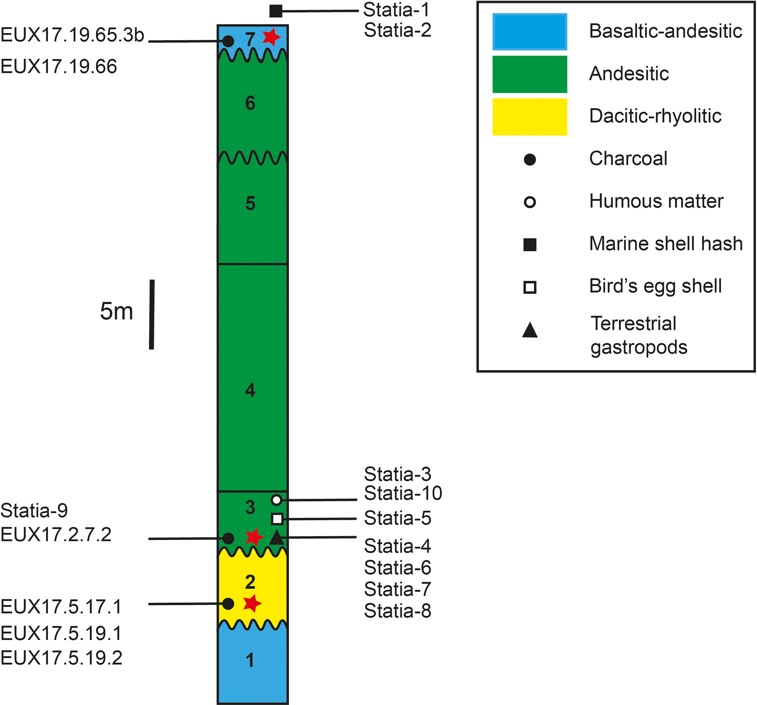
Figure 2. Schematic stratigraphic column for pyroclastic deposits along the north-eastern coast of St. Eustatius based on this study and Roobol and Smith (Reference Roobol and Smith2004). The thicknesses of the different divisions vary spatially, and in this stratigraphic column, the maximum thicknesses are shown. The chemical composition is based on the average of the different divisions. Sample numbers are from this study. The stratigraphic position of the published samples is indicated by a red star (Davidson, Reference Davidson1984; Roobol and Smith, Reference Roobol and Smith2004; van der Valk, Reference Van der Valk, Versteeg and Schinkel1992).
Division 1 consists of base surges with juvenile material of basaltic to andesitic composition (Roobol and Smith, Reference Roobol and Smith2004), indicating magma-water interaction with violent steam explosions. This division has not been dated, and a disconformity separates this unit from Division 2. Pyroclastic layers of flows, surges and falls with andesitic to rhyolitic compositions characterise Division 2. Two soil horizons have been observed within Division 2, indicating that it was deposited by at least three eruption phases. The boundary between Divisions 2 and 3 is characterised by an unconformity and a soil horizon at the top of Division 2. Charcoal derived from a fallen tree in Division 2 gave an age of 22 kyr BP (Roobol and Smith, Reference Roobol and Smith2004).
Division 3 is the most dated pyroclastic sequence of falls, flows and surges (Roobol and Smith, Reference Roobol and Smith2004). The six published 14C ages range between 7500 and 8250 yr BP (Table 1). The juvenile clasts from Division 3 vary in composition between andesitic and dacitic. While no soil horizons have been found in this division on the north-eastern coast, up to three soil horizons have been observed on the southwestern coast (Roobol and Smith, Reference Roobol and Smith2004; their section XVIII). This suggests that Division 3 is composed of at least four eruption phases. Division 4 consists of a sequence of course block and ash flows with a basaltic-andesitic to andesitic composition. One soil horizon was observed in this unit, indicating that it consists of at least two eruption phases. No charcoal has been found in this deposit. There is no soil horizon or disconformity between Divisions 4 and 5. Division 5 consists of ash flows with an andesitic composition; one soil horizon has been identified. Roobol and Smith (Reference Roobol and Smith2004) reported the presence of poor-quality charcoal in this deposit but did not date it. The boundary between Divisions 5 and 6 is an unconformity, and a soil developed in the topmost layer of Division 5. Division 6 is composed of basaltic andesite-to-andesite surge and flow deposits with one soil horizon. No age information is available for this unit. The contact with Division 7 is an unconformity.
Division 7 consists of the most recent set of five separate lithological units that were deposited during the most recent eruption phase of the Quill. Juvenile material is basaltic to andesitic in composition. No soil horizon has been observed in this unit, suggesting deposition in quick succession during a single eruption phase. Charcoal from Division 7 was dated by Roobol and Smith (Reference Roobol and Smith2004). It is unclear whether the age published by Roobol and Smith (1550 yr BP) corresponds to human or volcanic activity, as the ages overlap with two samples of posthole charcoal (1415–1545 yr BP) analysed by Versteeg and Schinkel (Reference Versteeg and Schinkel1992). In any case, the coincidence of dating evidence is striking.
The present study provides five new 14C analyses of charcoal from Divisions 2, 3 and 7 determined with modern highly sensitive Accelerator Mass Spectrometry (AMS) 14C dating techniques. These charcoal samples are complemented with nine samples of organic matter, bird eggshell material and terrestrial gastropod shell material from paleosols in the stratigraphic sequence. In addition, we convert the new and published 14C yr BP ages to the calibrated radiocarbon ages with the software package OxCal 4.4 (Bronk Ramsey, Reference Bronk Ramsey2009) with the recommended IntCal20 calibration curve (Reimer et al., Reference Reimer, Austin, Bard, Bayliss, Blackwell, Bronk Ramsey, Butzin, Cheng, Edwards, Friedrich, Grootes, Guilderson, Hajdas, Heaton, Hogg, Hughen, Kromer, Manning, Muscheler, Palmer, Pearson, Van der Plicht, Reimer, Richards, Scott, Southon, Turney, Wacker, Adolphi, Büntgen, Capano, Fahrni, Fogtmann-Schulz, Friedrich, Köhler, Kudsk, Miyake, Olsen, Reinig, Sakamoto, Sookdeo and Talamo2020).
Methods
Samples from tree trunks (charcoal) and twigs (charcoal), organic matter, as well as carbonate material (bird’s eggshell fragments and terrestrial gastropod shells) were collected from beach cliff outcrops and small quarries (see Fig. 1 for sample locations and Fig. 2 for stratigraphic position). The charcoal samples were first cleaned under a binocular microscope in order to remove non-charcoal material. Samples were then pretreated with an acid-alkali-acid method modified after Bayliss et al. (Reference Bayliss, McCormac and Van der Plicht2004) and Verstappen-Dumoulin et al. (Reference Verstappen-Dumoulin, Wietzes-Land and Meijer2020); see Fig. 3 for details. The samples were dated at the Groningen University AMS facility (Centre for Isotope Research – CIO) with a MICADAS 180 kV instrument (Dee et al., Reference Dee, Palstra, Aerts-Bijma, Bleeker, de Bruijn, Ghebru, Jansen, Kuitems, Paul, Richie, Spriensma, Scifo, Van Zonneveld, Verstappen-Dumoulin, Wietzes-Land and Meijer2020). The 14C ages are reported in years before present (before 1950 CE; yr BP) and converted to calibrated ages with the software package OxCal 4.4 (Bronk Ramsey, Reference Bronk Ramsey2009) with the recommended IntCal20 calibration (Northern Hemisphere) curve (Reimer et al., Reference Reimer, Austin, Bard, Bayliss, Blackwell, Bronk Ramsey, Butzin, Cheng, Edwards, Friedrich, Grootes, Guilderson, Hajdas, Heaton, Hogg, Hughen, Kromer, Manning, Muscheler, Palmer, Pearson, Van der Plicht, Reimer, Richards, Scott, Southon, Turney, Wacker, Adolphi, Büntgen, Capano, Fahrni, Fogtmann-Schulz, Friedrich, Köhler, Kudsk, Miyake, Olsen, Reinig, Sakamoto, Sookdeo and Talamo2020).
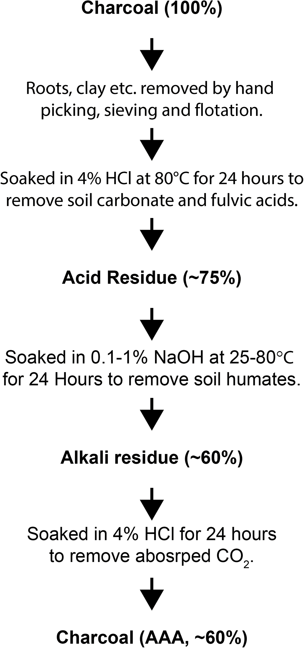
Figure 3. Pre-treatment procedure for charcoal samples. Percentages in brackets indicate the amount of material that remains after each step, relative to the initial amount of material. Modified from Bayliss et al. (Reference Bayliss, McCormac and Van der Plicht2004).
One charcoal sample (Statia-9) and 9 organic matter and carbonate samples (Statia-1–8, 10) have been dated in 1986 at the Groningen University AMS facility. These are reported in the same way as the samples analysed in 2018 (Table 2).
Table 2. New charcoal, organic and carbonate material 14C ages of St. Eustatius.
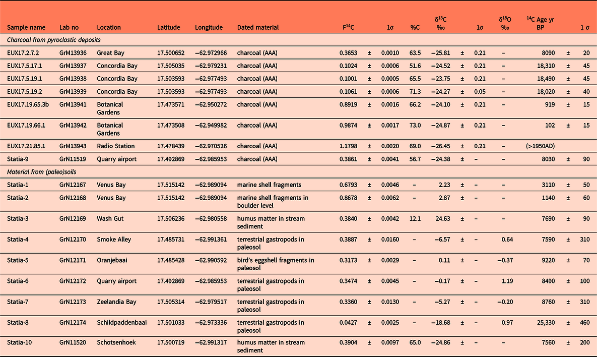
New radiocarbon ages from charcoal derived from pyroclastic deposits from the Quill, St Eustatius (analysed in 2018) and carbonate and organic material from a volcanic deposit and (paleo)soils (analysed in 1986). Latitude and longitude are given in WGS84 decimal coordinates. Abbreviations: AAA, acid-alkali-acid leaching, see methods and Fig. 3. The δ13C and δ18O are reported relative to the PDB standard and measured by IRMS. Lab numbers are those of CIO Groningen.
Results
In total, 9 charcoal samples were processed for 14C age determinations. One sample (EUX17.14.52.1d) did not provide a result as it contained not enough carbon. Two samples (EUX17.19.66.1 and EUX17.21.85.1) gave recent 14C ages of less than ∼100 yr BP. Three 14C ages for a single Division 2 layer sampled in two localities gave ages within 500 yrs: 18,020 ± 40, 18,310 ± 45 and 18,490 ± 45 yr BP (see Fig. 1). A single charcoal sample from Division 3 gave an age of 8090 ± 15 yr BP. Sample Statia-9, taken from a surge layer in Division 3 in a small quarry on the Cultuurvlakte, has an age of 8030 ± 40 yr BP. A charred tree root sample was collected from Division 7 (EUX17.19.65.3b) and gave an age of 919 ± 15 yr BP (Table 2).
Two marine shell fragment samples from Venus Bay (Statia-1 & 2) gave an age of 3110 ± 50 and 1140 ± 60 yr BP, respectively. Two samples of humus matter in stream sediments (Statia-3 and 10) gave 7690 ± 90 and 7560 ± 200 yr BP, respectively. Carbonate material of terrestrial gastropods and bird’s eggshell fragments from paleosols (Statia-4–7) vary in age between 7590 ± 310 and 9220 ± 70 yr BP. One sample of terrestrial gastropods from a paleosol from Schildpaddenbaai (Statia-8) is significantly older: 25,330 ± 460 yr BP.
The δ18O values of the carbonate material of the terrestrial gastropods vary between −0.20 and 1.19‰ (PDB), whereas the single sample of a bird’s eggshell gave a value of −0.37‰ (PDB). The δ13C values for terrestrial gastropod shell and bird’s eggshell material vary between −18.7 and 0.11‰. Charcoal is characterised by more negative δ13C values and varies between −26.4 and −23.8‰.
Discussion
Charcoal samples
The two samples (EUX17.19.66.1 and EUX17.21.85.1) with ages younger than 100 yr BP are probably charred pieces of roots that are the result of human activity such as slash and burn agriculture. Since no volcanic eruptions have been reported after Europeans arrived on St. Eustatius, these results are not further discussed. The other six new and eight published charcoal radiocarbon ages were converted to calibrated dates; the results are shown in Fig. 4A-C. Three samples from the bottom ignimbrite layer of Division 2 (Lower Pumice Division) yield a calibrated age range of 19,880−20,540 yr cal BC (95.4% probability). A charcoal sample (E126) from the same layer analysed by Roobol and Smith (Reference Roobol and Smith2004) produced a date range of 24,110−25,030 yr cal BC (95.4% probability), that is, significantly older (∼4400 yr) than the results from the present study. Given the careful pre-treatment of the samples of this study and the good agreement between the three samples from two localities, we conclude that the correct deposition date for the oldest deposit of Division 2 is 20,200 ± 300 yr cal BC (2sd), ∼4400 yr younger than the previous estimate.
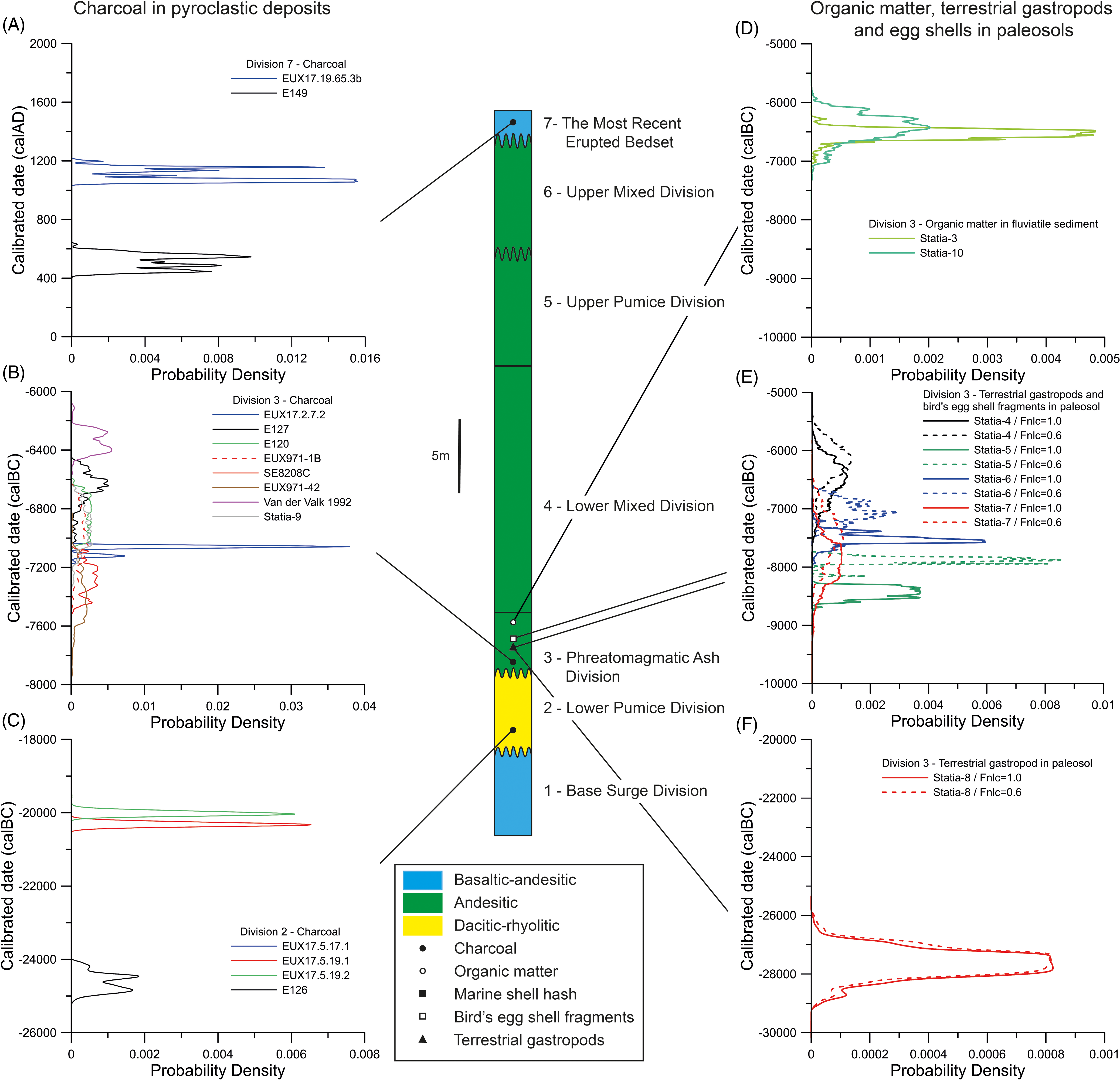
Figure 4. Calibrated 14C ages produced with the software package OxCal 4.4 (Bronk Ramsey, Reference Bronk Ramsey2009) with the recommended IntCal20 calibration (Northern Hemisphere) curve (Reimer et al., Reference Reimer, Austin, Bard, Bayliss, Blackwell, Bronk Ramsey, Butzin, Cheng, Edwards, Friedrich, Grootes, Guilderson, Hajdas, Heaton, Hogg, Hughen, Kromer, Manning, Muscheler, Palmer, Pearson, Van der Plicht, Reimer, Richards, Scott, Southon, Turney, Wacker, Adolphi, Büntgen, Capano, Fahrni, Fogtmann-Schulz, Friedrich, Köhler, Kudsk, Miyake, Olsen, Reinig, Sakamoto, Sookdeo and Talamo2020). The calibrated 14C ages are from this study (EUX17 and Statia sample numbers) and previously published 14C ages for charcoal (solid circles) derived from pyroclastic deposits, organic matter (open circles) and carbonate material (open/solid squares, solid triangles) from paleosols of the Quill (see Fig. 1 for locations). For the Division 3 14C age determination by van der Valk (Reference Van der Valk, Versteeg and Schinkel1992), an error of 75 yr (1sd) was assumed. The reservoir effect of the calibrated ages of carbonate material is indicated by dashed lines (Fnlc = 0.6), and the error was assumed to be the same as for the uncorrected age (Fnlc = 1.0). See text for discussion.
Two new charcoal samples were obtained from Division 3 (EUX17.2.7.2 and Statia-9). Sample EUX17.2.7.2 yield a narrow-calibrated date range of 7040−7138 yr cal BC, with the highest probability at 7060 yr cal BC. The other sample, Statia-9, has a much larger age spread of 6600−7300 yr cal BC. The calibrated age of EUX17.2.7.2, analysed in 2018, corresponds to the median of the wider range of six previously published radiocarbon ages for this deposit (6200−7800 yr cal BC; Fig. 4). Previously published ages and sample Statia-9 have a significantly larger spread in the calibrated dates due to the larger error in the measurements (see Fig. 4B). The samples from Roobol and Smith (Reference Roobol and Smith2004) are from different localities (See Fig. 1). Sample EUX971-42 is from the northeast coast, sample E127 from the southwest coast and samples EUX971-1b and E120 from the Cultuurvlakte (see Fig. 1). All these samples are from marker E of Roobol and Smith (Reference Roobol and Smith2004), which consists of a succession of fall – and surge deposits with juvenile clasts of grey semi-vesicular andesite and andesitic pumice. Roobol and Smith (Reference Roobol and Smith2004) report that their youngest sample (E127), which corresponds to our sample EUX17.2.7.2, is from a surge deposit that contains semi-vesicular clasts, whereas other samples from the same division (E120, EUX971-42, SE8208C) are pumiceous, suggesting that they could be derived from different eruption phases. However, in the Appendix (Plate 5) of Roobol and Smith (Reference Roobol and Smith2004), all charcoal samples are reported as taken from semi-vesicular andesite surge deposits. Additionally, Roobol and Smith (Reference Roobol and Smith2004) report one paleosol in their section XVII and three in section XVIII on the southwest coast. This suggests that Division 3 was formed by more than four eruption phases of volcanic activity separated by at least a centennial-scale period (but likely much longer, in view of the dry local climate), the time it is estimated to take to develop a soil layer (as discussed further below). Unfortunately, none of the carbon-dated samples of Roobol and Smith (Reference Roobol and Smith2004) are derived from section XVIII, so it is not possible to estimate how long the periods of volcanic quiescence were during Division 3. The wide range in published radiocarbon ages from this deposit could therefore be caused by samples from four different eruption phases. The radiocarbon dates of this study (Statia-9 and EUX17.2.7.2) are within ±300 yrs of the published ages. Therefore, we conclude that the higher precision 14C date of EUX17.2.7.2 is probably the most accurate for Division 3, with the possibility that Division 3 spans a wider age range due to the presence of at least four different eruption phases.
A Division 7 charcoal sample gave an age of ∼1100−1200 yr cal AD, that is, significantly younger than the 1550 yr BP (∼400−600 yr cal AD) reported for a similar sample by Roobol and Smith (Reference Roobol and Smith2004). Our sample (EUX17.19.65.3b) probably records charcoal produced by a forest fire or human activity, because it is derived from a tree root (which grew into Division 7 after its deposition. Artefacts from Amerindians on St Eustatius have been dated between 580 and 1755 yr BP (241−362 to 1275−1450 yr AD; see summary by Napolitano et al., Reference Napolitano, DiNapoli, Stone, Levin, Jew, Lane, O’Connor and Fitzpatrick2019). This age range overlaps with the dates of Roobol and Smith (Reference Roobol and Smith2004) and sample EUX17.19.65.3b of the present study for Division 7. Roobol and Smith (Reference Roobol and Smith2004) argue that the date of sample E149 could represent the eruption time for the deposits of Division 7. They based this on radiocarbon dates that had been reported for charcoal found in the backfill of postholes (1635−1775 yr BP), whereas the charcoal of the posts themselves have ages of approximately 1200−1350 yr BP (see discussion by Roobol and Smith, Reference Roobol and Smith2004). The diagram and photo (figures 13a and b of Van der Valk (Reference Van der Valk, Versteeg and Schinkel1992)) show clearly that the deposits of the last eruption(s) of the Quill (Layers 1a-d and 2a) at this location are disturbed by the postholes the Amerindians dug into these layers. Therefore, the last eruptions occurred before the Amerindians arrived on St Eustatius. The postmold charcoal ages vary between 1205 ± 30 and 1350 ± 60 yr BP (∼780−890 cal AD) (Versteeg, Reference Versteeg, Versteeg and Schinkel1992 and Roobol and Smith, Reference Roobol and Smith2004). Older charcoal has been found in the posthole backfill at the Golden Rock site (1635 ± 20 and 1775 ± 20 yr BP) and on an ancient surface at the Smoke Alley site 1720 ± 30 yr BP). The calibrated ages for these older charcoals are ∼ 340−480 calAD (Bronk Ramsey, Reference Bronk Ramsey2009; Reimer et al., Reference Reimer, Austin, Bard, Bayliss, Blackwell, Bronk Ramsey, Butzin, Cheng, Edwards, Friedrich, Grootes, Guilderson, Hajdas, Heaton, Hogg, Hughen, Kromer, Manning, Muscheler, Palmer, Pearson, Van der Plicht, Reimer, Richards, Scott, Southon, Turney, Wacker, Adolphi, Büntgen, Capano, Fahrni, Fogtmann-Schulz, Friedrich, Köhler, Kudsk, Miyake, Olsen, Reinig, Sakamoto, Sookdeo and Talamo2020). Roobol and Smith (Reference Roobol and Smith2004) suggest that these older charcoal could be derived from the youngest pyroclastic deposits. On the other hand, Versteeg and Schinkel (Reference Versteeg and Schinkel1992) interpreted these older charcoals as derived from burning of plots for agricultural use, before habitation. The last option seems to us the most likely, as charcoal in pyroclastic deposits is rare. The last eruption of the Quill would then be older than 400 AD. In summary, a definite age for the last eruption of the Quill remains poorly constrained with the best estimate being older than 600 AD (sample E149 from Roobol and Smith (Reference Roobol and Smith2004)) but definitively younger than 6100 ± 500 yr cal BC (see below).
The unsatisfactory situation regarding the ages of the Division 4−7 can probably only be resolved by studying piston cores that need to be collected around the island of St Eustatius. Correlations between volcanic ash layers and the age of the marine sediment layers in such piston cores are the way to determine the ages of these Divisions.
Ages of paleosols
Although carbonate and carbon material from soil horizons do not provide a direct age of volcanic eruptions as charcoal does, it can provide important information on the age of soil horizon(s) that developed between different eruption intervals. Two samples (Statia-3 and 10) of organic material derived from small stream deposits that developed in Division 3 have ages of 7560 ± 200 and 7690 ± 90 yr BP (6000−7000 yr cal BC, see Fig. 4D). The ages of Statia-3 and 10 are ∼500 yr younger than the best analysis of charcoal of Division 3 (sample EUX17.2.7.2, Fig 4b), indicating that Division 4 must be younger than 6400 yr cal BC.
The carbonate material of this study consists of bird’s eggshell fragments and terrestrial gastropod shells. The ages of these materials are offset by a largely unknown amount, since the dead carbon effect results in ages that are too old (e.g. Pigati et al., Reference Pigati, Rech and Nekola2010). Terrestrial gastropods incorporate carbon from four different sources: (1) atmospheric CO2; (2) food; (3) water; and (4) carbonate material from the soil (limestone, old shells, etc) (see review by Pigati et al., Reference Pigati, Rech and Nekola2010). Atmospheric CO2 is incorporated in the shell through respiration. It is thought that the contribution of dead carbon varies from negligible to 68%. Terrestrial gastropods ingest food from a range of sources such as living plants, fungi and organic detritus, with individual carbon contributions for these sources ranging between 25 and 100%. Water (dew, precipitation, standing water) with dissolved inorganic carbon is also consumed by terrestrial gastropods. The amount of carbon with dissolved inorganic carbon is only known for one species and is estimated at 10% (Pigati et al., Reference Pigati, Quade, Shanahan and Haynes2004). The final source, carbonate material from limestone, can be ingested by some terrestrial gastropods by mechanically scraping limestone or dolomite rock. For some larger gastropods this can contribute up to 30% of the carbon in the shell.
Pigati (Reference Pigati2002) provided a method to estimate the maximum dead carbon effect on the 14C age of terrestrial gastropod shells. The fraction of carbonate material (f nlc) is set to 1.0 (no carbonate incorporated) and 0.6, the minimum value observed in a study by Goodfriend and Hood (Reference Goodfriend and Hood1983). This results in an age correction between 101 and 401 years (see Table 3) which is small (1.4-5.3%). We applied the same correction to bird’s eggshell fragments, assuming that birds do incorporate carbonate by eating organic material. If these birds were fish eaters (which is very likely), the maximum 14C age correction (assuming f nlc = 0.6) is similar to that of terrestrial gastropods (407 yr).
Table 3. Maximum calculated reservoir effects of terrestrial gastropods and bird eggshell carbonate samples.
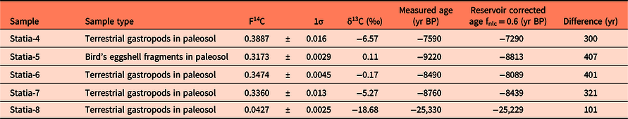
Calculated maximum dead carbon effect on the 14C age based on the procedure of Pigati (Reference Pigati2002). The fraction of non-limestone carbon (fnlc) is set at 0.6, and the difference between δ13C of aragonite calcite (Δa-c) is set to 1.8‰. See text for discussion.
Statia-1 and Statia-2 are composed of marine shell fragments from two beach levels at Venus Bay (see Fig. 1) that are now exposed above the present-day beach. If the eggshell material has not been moved by waves or wind, the ages of 3110 and 1140 yr BP, respectively, indicate that the Venus Bay area of the Northern Volcanic Complex has been uplifted in the past 3000 years by approximately 3 m (sample collected 2.75 m above sea level, 3000 yr ago sea level was 0.3 m lower than present day (Rohling et al., Reference Rohling, Medina-Elizalde, Shepherd, Siddall and Stanford2012)).
The terrestrial gastropods that are found in different soil horizons (Statia-4, 6 and 8) of Division 3 have ages between 7590-8760 14C yr BP with corrected ages for the dead carbon effect and calibrated ages between 5500 and 8800 yr cal BC (Fig. 4E). Our best estimate for the eruption age of Division 3 is our new age for sample EUX17.2.7.2 with an age of 7000−7200 yr cal BC. As discussed above, this division contains at least four different eruption phases, separated by unconformities and paleosols. Given the spread in the terrestrial gastropod ages, Division 3 represents at least a period of 3300 yr, in which one of the eruption phases occurred between 7000 and 7200 yr cal BC. This period of 3300 yr is consistent with the large spread of 1400 yr observed in the published 14C ages of charcoal from Division 3 (see Fig. 4B).
The youngest dated terrestrial gastropod (Statia-4) in a Division 3 soil horizon has a corrected calibrated age of 6100 yr cal BC (see Fig. 4E). This is approximately 300 years younger than the organic material from streams in Division 3 (samples Statia-3 and 10). Given the relatively large errors on the calibrated ages in his time interval (±500 yrs), a maximum age of 6100 ± 500 yr cal BC for Division 4 is currently our best estimate.
Sample Statia-8 gives an anomalous age of 25,330 yr BP, although it is derived from one of the Division 3 paleosols. This could be explained that this terrestrial gastropod was incorporated in Division 3 by surges that eroded Division 2 and/or 1. Indeed, this terrestrial gastropod has an age which is older than the Division 2 ages we obtained. Another possibility is that this gastropod has an anomalous age due to 14C loss caused by leaching/precipitation of carbonate material when it was buried in the soil. An anomalous δ13C value (−18.68‰) for sample Statia-8, compared to the other gastropods of Division 3 soil horizons that have δ13C close to zero (see Table 2), also suggests that the age determined of this sample is probably incorrect.
The carbon isotope composition of the terrestrial gastropod shells is mainly determined by the diet. The estimated δ13C offset between the dietary and the shell carbon is +12.3‰ (Stott, Reference Stott2002), resulting in a dietary δ13C of −12.2‰ and −18.9 for the ∼8000 BP terrestrial gastropods. These values overlap with C4 and CAM plants (δ13C = −10 to −14‰ and −14 to −20‰, respectively; Deines, Reference Deines, Fritz and Fontes1980). The Statia-8 terrestrial gastropod with an 25,330 BP 14C age would have had a diet with organic material with an average value of δ13C = −31‰. If this 13C value is correct (see discussion above for this sample), this would suggest a diet dominated by C3 plants that have a δ13C of −25‰ (Deines, Reference Deines, Fritz and Fontes1980) in a wet climate (>500 mm yearly rainfall, Kohn, Reference Kohn2010).
Oxygen isotope composition of the terrestrial gastropod shells should record the oxygen isotope composition of the seasonal fluctuations in rainfall, as the annual temperature variation of St. Eustatius is small (<3°C). The small variations in the oxygen isotopes of the St. Eustatius terrestrial gastropods carbonate shell would then record variations between drier and wetter climate. Beets et al. (Reference Beets, Troelstra, Grootes, Nadeau, van der Borg, Jong, Hofman and Hoogland2006) reported the stable isotope composition of terrestrial gastropod shells in a similar environment on Guadalupe and concluded that terrestrial gastropods record isotopic variations under wetter and drier conditions. The climate during the soil formation after deposition of Division 3 was wet, based on the oxygen isotope composition of other carbonate-secreting organisms in the Caribbean region. Figure 5 shows the δ18OPDB variation of an ostracod species (Candona sp.) versus age in Lake Miragoane deposits, Haiti (Hodell et al., Reference Hodell, Curtis, Jonest, Higuera-Gundy, Brenner, Binfordll and Dorsey1991). The soils that developed during and after the deposition of Division 3 were most likely formed in a climate that changed from dry at 10kyr BP to a more wet climate at 7kyr BP (Fig. 5).

Figure 5. Oxygen isotopes of ostracod species Candona sp.6 (blue curve) form a core taken from Lake Miragoane, Haiti (after Hodell et al., Reference Hodell, Curtis, Jonest, Higuera-Gundy, Brenner, Binfordll and Dorsey1991). The light grey areas indicate high evaporation/precipitation ratio (dry climate), whereas the dark grey age intervals indicate low evaporation/precipitation ratio (wetter climate). Black triangles are oxygen isotopes from three terrestrial gastropods from Division 3 of St. Eustatius. These show that during the deposition of Division 3, the climate changed from a dry to more humid climate. The yellow line is a measure for the solar intensity (the difference in insolation (Langleys)) at the top of the atmosphere at 10 °N latitude between the months of August and February, from Hodell et al. (Reference Hodell, Curtis, Jonest, Higuera-Gundy, Brenner, Binfordll and Dorsey1991)). The St. Eustatius samples are close to the insolation maximum at 7000 BP.
Minimum eruption frequency over the last 22 kyr for the Quill volcano
Based on our own field observations and the stratigraphic columns of Roobol and Smith (Reference Roobol and Smith2004), the subaerial pyroclastic sequence of the Quill was formed by at least 16 different eruption phases (Fig. 6). We define an eruption phase as a period of one or more volcanic eruptions that are separated by intervals of quiescence (<50 years, see below), such that no soil horizons are formed. In the stratigraphic succession, an eruption phase would consist of successive pyroclastic layers separated by soil horizons and/or major disconformities. Current soil formation on St Eustatius is a slow process. The soil that developed in situ on the Cultuurvlakte is only about 10−20 cm thick (Veenenbos, Reference Veenenbos1955). Assuming that the 1600 yr BP age for the last eruption is correct, then it takes more than 1500 years to develop a significant soil horizon but in all likelihood a longer period is needed. A similar observation was made by Smith and Roobol (Reference Smith and Roobol1990) who studied the 1902−1905 and 1929−1932 eruptions of Mt Pelée (Martinique) and found very poorly developed soil layers, more than 60 years after the eruption. The soil horizons observed in the subaerial Quill deposits therefore represent periods of at least 50 and probably 100s or even 1000s of years of quiescence.

Figure 6. The subaerial pyroclastic sequence of the Quill was formed by at least 16 eruption phases separated by disconformities and/or soil horizons. The different eruption phases have been named after the number of the stratigraphic divisions of Roobol and Smith (Reference Roobol and Smith2004) and a letter for the different phases within each division.
It is important to stress that the 16 eruption phases observed in stratigraphic sections along the coast and in quarries on St. Eustatius provide a minimum estimate. Pyroclastic deposits can easily be eroded by subsequent pyroclastic density flows or rain/landslides during occasionally occurring hurricane events. In addition, the wind direction could be such that an eruption is not recorded on large parts of the Quill volcano. The minimum eruption frequency over the last 22 kyr (Division 2 to present) is therefore ∼1400 yr.
Although the Quill volcano is often described as ‘dormant’, the minimum eruption frequency during the past 22.000 years confirms that civil authorities should treat it as an active volcano.
The Quill compared to other young volcanic centres of the northern Lesser Antilles arc
Figure 7A and B show the published 14C and/or 39Ar/40Ar ages for Saba, Mt Liamuiga (St Kitts) and Soufrière Hills (Montserrat) compared to the volcanic deposits of the Quill (St. Eustatius). The Quill is a very young volcano compared to these volcanic centres. The 39Ar/40Ar ages of Saba are all from before the development of a collapsed structure, called horseshoe-shaped structure by Roobol and Smith (Reference Roobol and Smith2004). This structure is probably 100kyr old, whereas the oldest dated rocks of Saba are 420 kyr. The two young 14C ages suggest that an eruption occurred just before European settlement around 1640 AD. The age information of Saba is too limited for a discussion regarding eruption frequency.

Figure 7. Ages of volcanic deposits of The Quill (St Eustatius) compared to those of Saba, Mt Liamuiga (St. Kitts) and Soufrière Hills (Montserrat). References: Baker (Reference Baker1969), Baker (Reference Baker1985), Defant et al. (Reference Defant, Sherman, Maury, Bellon, de Boer, Davidson and Kepezhinskas2001), Harkness et al., (Reference Harkness, Roobol, Smith, Stipp and Baker1994), Roobol et al. (Reference Roobol, Smith and Wright1981), Roobol and Smith (Reference Roobol and Smith2004), and Harford et al. (Reference Harford, Pringle, Sparks and Young2002). Note vertical scale differences between the two graphs. See text for discussion.
The most complete pyroclastic section of Mt. Liamuiga, 25 km SE of The Quill, has been obtained from the Mansion Series (Roobol et al., Reference Roobol, Smith and Wright1981). This sequence is between 1750 and more than 41,520 yr BP old and contains 16 paleosols. This would result in a >2500 yr eruption frequency, with the remark that this could be much larger if the age of the lower part of the Mantion Series is much older than 41 kyr or much smaller if deposits have been eroded away or have been deposited on other parts of the island.
The Soufrière Hills volcano on Montserrat has been active for more ∼175 kyr and has therefore been active for a much longer time than the Quill. Its stratigraphy is divided into four units from old to young: SH-I, SH-II, SH-III and SH-G (Roobol and Smith, Reference Roobol and Smith1998; Harford et al., Reference Harford, Pringle, Sparks and Young2002). The best-studied pyroclastic unit is SH-III, which was deposited over a period of 15 kyr from ∼ 32 kyr to ∼ 17 kyr BP (Roobol and Smith, Reference Roobol and Smith1998). Between SH-III and SH-G (4 kyr BP) was a period of 13 kyr quiescence with no or only minor eruptions. The last eruption, associated with the Castle Peak Dome, occurred in 1630 AD. The SH-III unit consists of at least four eruptions (probably more, given that one soil horizon is reported by Roobol and Smith, Reference Roobol and Smith1998). This would result in a minimum eruption frequency of 1 every 5.000 yr. Again, this is a minimum estimate.
The comparison with other young northern Lesser Antilles Arc volcanoes shows that the Quill is a very young volcano. Periods of quiescence of ∼15 kyr occurred both on Montserrat (between SH-III and SH-G) and St Eustatius (between deposition of Division 2 and 3). The eruption frequency of the northern Lesser Antilles Arc volcanoes is probably generally >1000 yr.
Conclusions
-
1. The oldest dated deposit of the subaerial part of the Quill (Lower Pumice Division, 2) has an age of 20,000 yr cal BC, significantly younger (∼4400 yr) than a previously published finding.
-
2. Stratigraphic Division 3 has an age of 7100 yr cal BC, overlapping with many previous published results. This division consists of four different eruption phases explaining variation in published radiocarbon dates.
-
3. Based on terrestrial gastropods found in paleosols of Division 3 and organic matter found in streams that developed in Division 3, Division 4 must be younger than 6100 ± 500 yr cal BC.
-
4. The age of the last eruption of the Quill remains poorly constrained with the best estimate being older than 600 AD.
-
5. Soils that developed in and on top of Division 3 were formed in a climate that changed from drier to wetter conditions. Carbon isotopes indicate that C4 and CAM-type vegetation was dominant, which contrasts the current wetter conditions.
-
6. The Quill is a young volcano compared to other active volcanic centres of the northern Lesser Antilles arc. The minimum eruption frequency of the Quill volcano was one eruption every ∼1400 years during the past 22.000 years (Division 2 – present day), the same order of magnitude as Soufrière Hills (Montserrat, ∼5000 years) and Mt Liamuiga (St. Kitts, ∼2500 years).
Acknowledgements
Ayala Juliana and Ruth Strootman assisted with the collection of the charcoal samples and description of the stratigraphic columns. We would like to thank Dr S. Palstra and Dr L de Jong (CIO, Groningen) for providing the 1986 data and assisting with the preparation of radiocarbon analyses. Hessel Woolderink explained how to clean and prepare the charcoal samples. PZV would like to thank Dr Nathalie van der Putten and Dr Kay Beets with the help of the interpretation of the 14C age results and dead carbon effects. This project was financially supported by the Vrije Universiteit Amsterdam (1980’s fieldwork and radiocarbon analyses), TNO and Molengraaff fund. This research received funding from the European Research Council under the European Union’s Seventh Framework Programme (FP7/2007-2013) / ERC grant agreement n° 319209 (ERC-Synergy NEXUS 1492). We would like to thank Prof. Alan Smith and 3 anonymous reviewers for constructive criticism that significantly improved previous versions of this paper.


 Open access