


1. INTRODUCTION
‘[Small glaciers] are the products of avalanches, the crushed ice being recompacted into a solid mass, which exhibits on a smaller scale most of the characteristics of the large glaciers.’ − John Tyndall, The Glaciers of the Alps, Reference Tyndall1896
Cirques are abundant and prominent features of glacially sculpted landscapes. Glaciers shape cirques both by directly eroding bedrock and by removing fragmentary products of weathering. Such action as geomorphological agents provides one motivation for studying glaciers occupying cirques. A second motivation is that cirque glaciers are often the last remnants of ice in warming landscapes, and their further evolution captivates interest.
The most widespread view of cirque glaciers, arising from work by Lewis in Norway during the 1950s (McCall, Reference McCall1952; Lewis, Reference Lewis and Lewis1960), characterizes their movement as nearly rigid rotation with rates of basal sliding far exceeding internal deformation. This end-member model is appealingly simple and has allowed scientists to essentially ignore ice dynamics in analyses of both cirque glaciers and cirque development and morphology (e.g. Weertman, Reference Weertman1971; Barr and Spagnolo, Reference Barr and Spagnolo2013; Mîndrescu and Evans, Reference Mîndrescu and Evans2014). Although it may apply to some very thin and small ice bodies, this model is certainly wrong for glaciers of dimensions comparable to most cirques (Sanders and others, Reference Sanders, Cuffey, MacGregor, Kavanaugh and Dow2010). Dynamically, cirque glaciers in temperate environments are similar to larger temperate glaciers.
The dominance of the rigid-rotation model and the paucity of glaciological studies in cirques hinder the development of process-based understanding of cirque formation. Although geomorphologists have studied cirques since the 19th century (e.g. Gastaldi, Reference Gastaldi1873), basic questions such as ‘How rapidly did this cirque form?’ or ‘Why is one cirque overdeepened and another not?’ are still unanswerable. Numerical models developed to probe such questions can provide valuable insights but remain poorly parameterized (MacGregor and others, Reference MacGregor, Anderson and Waddington2009). Insufficient knowledge about cirque glaciers weakens arguments – such as the glacial buzzsaw theory – dependent on the morphology or geographic location of cirques (e.g. Porter, Reference Porter1989; Mitchell and Montgomery, Reference Mitchell and Montgomery2006; Anders and others, Reference Anders, Mitchell and Tomkin2010).
We have previously reported results from our case study of a temperate cirque glacier in the Canadian Rockies, with a focus on the spatial pattern of flow and sliding (Sanders and others, Reference Sanders, Cuffey, MacGregor, Kavanaugh and Dow2010), subsurface hydrology (Kavanaugh and others, Reference Kavanaugh, Moore, Dow and Sanders2010; Dow and others, Reference Dow, Kavanaugh, Sanders, Cuffey and MacGregor2011, Reference Dow, Kavanaugh, Sanders and Cuffey2014), and processes of erosion and sediment transport (Sanders and others, Reference Sanders, Cuffey, MacGregor and Collins2013). The present manuscript aims to be a succinct report of observations of temporal variations in sliding motion of the glacier, and how such variations fit into the seasonal evolution of the subglacial hydrological system. We show that cirque glaciers can share the characteristic temporal behavior of larger temperate glaciers, on daily to seasonal timescales, including ‘spring event’ speed-ups. Apart from their inherent interest as manifestations of the coupled ice flow and hydrological system, temporal variations of slip rate hold interest for their possible connections to subglacial erosion. If erosion depends on slip rate in a non-linear manner, as appears likely (Hallet, Reference Hallet1979, Reference Hallet1996; Herman and others, Reference Herman2015), the cumulative erosion of a glacier's bed depends not only on the net slip but also on how episodically or continuously the displacement occurs. Intervals of fast slip may also activate erosional processes associated with pulses of extreme pressure (Kavanaugh and others, Reference Kavanaugh, Moore, Dow and Sanders2010) and related phenomena.
In this paper, we first briefly summarize the typical behavior of temperate glaciers during the melt season, and then describe our field site and measurement strategies. We interpret our observations in the context of prior knowledge about coupling of basal slip and hydrology and their seasonal coevolution and briefly discuss some implications of our work with respect to the formation of cirques.
1.1. Temporal evolution of a ‘typical’ temperate valley glacier
Extensive study of the seasonal variation of temperate valley glacier behavior (including Meier, Reference Meier1960; Paterson, Reference Paterson1965; Hodge, Reference Hodge1974; Iken, Reference Iken1977; Hooke and others, Reference Hooke, Brzozowski and Bronge1983; Iken and others, Reference Iken, Röthlisberger, Flotron and Haeberli1983; Iken and Bindschadler, Reference Iken and Bindschadler1986; Naruse and others, Reference Naruse, Fukami and Aniya1992; Willis, Reference Willis1995; Harper and others, Reference Harper, Humphrey and Greenwood2002; Anderson and others, Reference Anderson2004; MacGregor and others, Reference MacGregor, Riihimaki and Anderson2005) has led to the following phenomenological understanding. (In this section, citations direct the reader to a few specific examples and are not intended to be comprehensive.) Except under thin ice, the ‘winter’ configuration prevailing at melt season onset is characterized by small or absent subglacial cavities forming a weakly connected linked network on the bed (Willis, Reference Willis1995; Nienow and others, Reference Nienow, Sharp and Willis1998). Subglacial water pressure is typically high but the volume of water and its spatial extent are limited (Iken, Reference Iken1981). Proglacial discharge varies diurnally only weakly (Nienow and others, Reference Nienow, Sharp and Willis1998; Mair and others, Reference Mair, Nienow, Sharp, Wohlleben and Willis2002a; MacGregor and others, Reference MacGregor, Riihimaki and Anderson2005), and the glacier slides slowly (Paterson, Reference Paterson1965).
As the melt season develops, meltwater and rain reach the bed and increase the volume of water in and under the ice, often also raising subglacial water pressures and lowering effective pressures (e.g. Iken and Bindschadler, Reference Iken and Bindschadler1986). Sustained low effective pressures and/or flooding of the bed lead to a period of enhanced basal slip lasting weeks to months (Paterson, Reference Paterson1965; Iken, Reference Iken1977; Hooke and others, Reference Hooke, Brzozowski and Bronge1983; Gudmundsson and others, Reference Gudmundsson2000; Harper and others, Reference Harper, Humphrey and Greenwood2002; Sugiyama and Gudmundsson, Reference Sugiyama and Gudmundsson2004). Slip rates increase transiently because high water pressures push on downglacier-dipping ice faces, and increased water volume separates the glacier sole from drag-producing roughness (Iken, Reference Iken1981; Humphrey, Reference Humphrey1987; Harper and others, Reference Harper, Humphrey and Greenwood2002; Cuffey and Paterson, Reference Cuffey and Paterson2010). Weakening of subglacial till can also play a role (Willis, Reference Willis1995).
Short-term, very rapid basal slip triggered by pulses of meltwater input sometimes occur. During these ‘motion events’, the glacier exhibits several phenomena. Surface speed can be several times above the background level (Gudmundsson and others, Reference Gudmundsson2000; Anderson and others, Reference Anderson2004). In some cases, these occur in isolated locations; in others they progress up- or down-glacier at several hundred meters per day (Hodge, Reference Hodge1974; Gudmundsson and others, Reference Gudmundsson2000; Anderson and others, Reference Anderson2004; MacGregor and others, Reference MacGregor, Riihimaki and Anderson2005). Transient, rapid slip can also cause vertical motion and changes of the glacier surface elevation relative to prevailing trends (Iken and others, Reference Iken, Röthlisberger, Flotron and Haeberli1983; Hooke and others, Reference Hooke, Calla, Holmlund, Nilsson and Stroeven1989; Mair and others, Reference Mair, Sharp and Willis2002b; Anderson and others, Reference Anderson2004; MacGregor and others, Reference MacGregor, Riihimaki and Anderson2005). Such ‘uplift’ events result, specifically, from cavity growth, longitudinal strain and shear-induced dilation of subglacial till (Iken and others, Reference Iken, Röthlisberger, Flotron and Haeberli1983; Hooke and others, Reference Hooke, Calla, Holmlund, Nilsson and Stroeven1989; Sugiyama and Gudmundsson, Reference Sugiyama and Gudmundsson2004). Lastly, rapid slip can also result in redistribution of resistive stresses (Kavanaugh and Clarke, Reference Kavanaugh and Clarke2001).
Later in the melt season, water flowing at the bed allows the subglacial drainage network to evolve into a high-efficiency channel network (Nienow and others, Reference Nienow, Sharp and Willis1998; Fountain and Walder, Reference Fountain and Walder1998). Effective drainage of water reduces basal water pressures and volumes. Consequently, the glacier slows and subglacial cavities begin to close. Pulses of water delivered to the bed tend to pass quickly through the glacier with only weak effects on the ice flow.
2. SITE DESCRIPTION AND FIELD MEASUREMENTS
2.1. West Washmawapta Glacier
We instrumented West Washmawapta Glacier, a small (1 km2), temperate glacier occupying an east-facing cirque carved in Helmet Mountain (elevation: 3124 m) of the Vermilion Range of British Columbia, Canada (Fig. 1). The glacier has been retreating since at least 1949. The glacier surface is steep below the headwall (20–40°) and above the lee side of the riegel, but relatively flat (4–8°) across a central overdeepened bowl (Figs 1, 2). In 2006, the average ice thickness was 70 m and the maximum ice thickness was ~185 m. The glacier generally flows northeastward with average surface speeds of 3–10 m a−1. Basal slip is negligible in the central bowl but increases toward the northern margin and the riegel, where slip accounts for ~70% of total motion in both regions (Sanders and others, Reference Sanders, Cuffey, MacGregor, Kavanaugh and Dow2010). Basal water pressure was measured in boreholes for almost a full year between 18 August 2007 and 8 August 2008. In late summer, water pressure varied diurnally, but overwinter, it remained consistently high (>90% of overburden) with occasional spikes and dips (Dow and others, Reference Dow, Kavanaugh, Sanders and Cuffey2014). Coarsely crystalline and sediment-rich ice sits directly on bedrock in marginal regions accessed by tunnels (Sanders and others, Reference Sanders, Cuffey, MacGregor and Collins2013), but a basal till layer may be present elsewhere. Using a camera lowered into boreholes, we identified clasts and clumps of sediment dispersed throughout the ice column; in some holes we encountered turbid water near the bed.
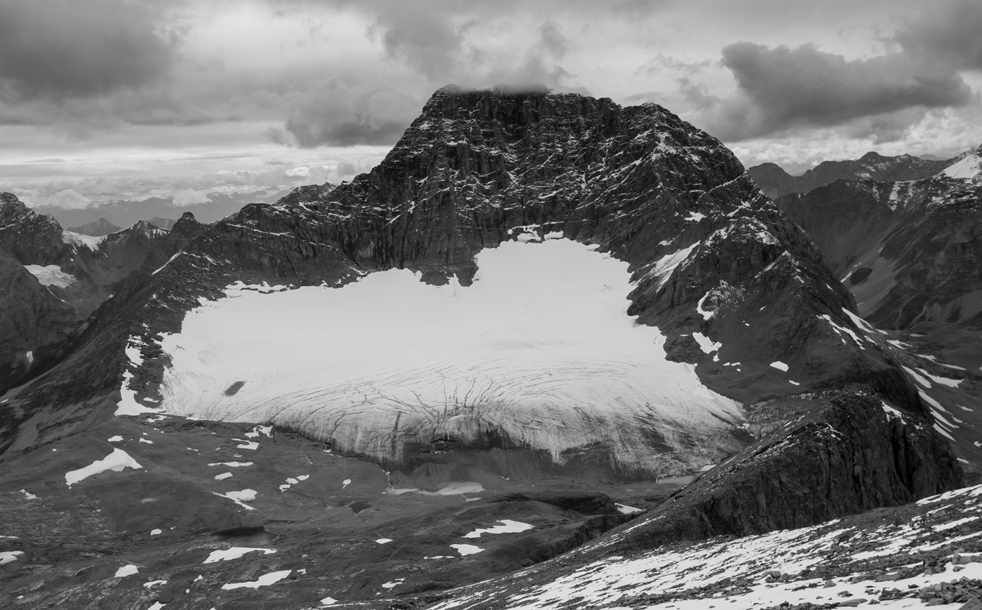
Fig. 1. Head-on view of West Washmawapta Glacier taken from the east in August 2008. Here a recent snowstorm hides the fact that the snowline has retreated well within the cirque. Outlet streams emerge from the toe in numerous locations. The glacier is ~1 km across and 1 km long.

Fig. 2. Map of West Washmawapta Glacier showing locations of continuous GPS stations, GPS base stations, stream gauges, the boreholes and weather stations. For the 2007 GPS sites only, the annual (‘winter’) surface velocity, peak surface velocity, surface slope and ice thickness are shown. Stream gauge 2 is located just north of the map boundary. The glacier center is located at 51.1773°N, 116.3296°W.
Extensive information about the site and our scientific methods were reported in Kavanaugh and others (Reference Kavanaugh, Moore, Dow and Sanders2010), Sanders and others (Reference Sanders, Cuffey, MacGregor, Kavanaugh and Dow2010), Dow and others (Reference Dow, Kavanaugh, Sanders, Cuffey and MacGregor2011, Reference Dow, Kavanaugh, Sanders and Cuffey2014) and Sanders and others (Reference Sanders, Cuffey, MacGregor and Collins2013). The measurements described below were collected between 28 June–18 August 2006, 12 May–28 August 2007 and 30 June–23 August 2018. The GPS devices and stream gauges ran automatically in our absence and, occasionally, experienced battery or mechanical failures that caused gaps of up to 2 weeks in our measurements.
2.2. Hydrology, water balance and weather
Downstream of West Washmawapta Glacier, all of the runoff coalesces into a single-thread bedrock channel. Discharge in this channel also includes runoff from a nearby, separate glacier, and we therefore installed two stream gauges to isolate the contributions (Fig. 2, labeled stream gauge 1 and stream gauge 2). The gauges operated in 2006 and 2007; no discharge measurements were obtained in 2008. We performed salt-discharge measurements at both sites simultaneously over the course of several days (Kite, Reference Kite1994; Sanders and others, Reference Sanders, Cuffey, MacGregor and Collins2013) in order to develop rating curves between stage and discharge for both gauges. Stage was measured with a Druck PDCR 1230 pressure transducer at stream gauge 1, and with a Campbell Scientific SR50 Sonic Ranging Sensor at stream gauge 2. A malfunction at gauge 2 erased data collected before 12 July 2007. To extend the record back in time, we extrapolated using the late-summer relationship between stream gauge 1 and 2 (r 2 = 0.94); during this period, the errors are therefore larger. For this reason, and because our glacier velocity data are daily averages (see below), we report proglacial discharge as daily totals. In mid and late summer, water discharge in the proglacial streams varies with a strong diurnal cycle. In winter, however, the streams and proglacial lakes are dry. See Sanders and others (Reference Sanders, Cuffey, MacGregor and Collins2013) for more information about the stream monitoring. No attempt was made to correct for changes in stored water volume within the proglacial lakes, because during the period of analysis (mid and late summer), the lakes remain filled and such changes are small; the entire volume of the lakes is equivalent to ~1 d of discharge from the basin.
Air temperature was recorded hourly at weather stations installed both on and off the glacier (Fig. 2). A tipping-bucket rain gauge, situated at stream gauge 1, measured rainfall. In summer, storms were typically of high intensity and short duration, rarely lasting more than 2 d. Afternoon thunderstorms were common. Occasionally, storms blanketed the cirque with snow and reduced proglacial discharge significantly for a day or two. At the on-glacier weather station, we measured the change in snow surface elevation with a downward-looking sonic sensor similar to that found at stream gauge 2.
We used the observed daily discharge, precipitation and snow surface lowering records to estimate a cirque-wide relative water balance between 3 July 2007 and 27 August 2007 (as the onset of melt preceded installation of our stream gauges, the absolute balance is not known). The water balance is defined so that positive values indicate storage of water within and beneath the glacier, while negative values indicate loss. For this rough calculation, we assumed rainfall and melt were uniform over the glacier and that the snow and ice density were everywhere 500 and 910 kg m−3, respectively. We ignored rainfall on the headwall and foreland because (1) their combined contributions to the balance are at least a factor of 10 smaller than melt and rain on the glacier and (2) karst features in the cirque bedrock make estimating infiltration loss challenging. Lastly, uncertainties in water inputs and exfiltration are large, so we adjusted the net balance rate by a constant offset selected to assure that late-season water storage is negligible. This assumption is plausible given that late in the summer, stream discharge was strongly diurnal and no speed-ups occurred (see below). In any case, this adjustment has little impact on the shorter term variations of balance that are of primary interest here.
2.3. Ice surface velocity
We installed continuously running Trimble 5700 GPS receivers on the glacier surface to measure displacement. Herein, we identify receivers by the year of installation followed by a letter; for example, GPS receiver A in year 2006 is called 6A. The antennas were attached to a triangular piece of plastic mounted on three 3 m long steel poles set into the ice or snow surface (as in Fig. 2 of Anderson and others, Reference Anderson2004). Two reference stations were installed on bedrock within 1 km of the on-glacier receivers (Fig. 2). The number of GPS receivers and duration of measurements varied from year to year. No receivers operated over the winter. In 2006, we installed two receivers on 25 June, one of which (6A) functioned and collected data until 18 August. The other's antenna support failed. The following year, in order to span the entire melt-season, we arrived on site in mid-May and installed four stations (Fig 2, stations 7a–d). The glacier was completely snow-covered at this time. In June, when we returned for maintenance, all but a small area near the margin remained snow-covered. The GPS stations operated until 26/27 August. Temporary battery failure following burial of the solar panels by snow led to three gaps in the 2007 displacement records. In 2008, our arrival was delayed until late June. We installed two receivers (8A and 8B) along the northern margin near two boreholes used for subglacial measurements (Fig. 2). These receivers operated from 29 June until 23/24 August.
In all seasons, the GPS receivers recorded data every 15 s for 24 h at a time. These data were subsequently converted to Rinex format, divided into 1 h intervals using TEQC, and post-processed in Trimble Geomatics Office™. We quantified horizontal and vertical error magnitude by assuming that random lateral and vertical shifts in position to either side of the prevailing velocity vector were error-induced. Horizontal and vertical position errors were both ~5 mm, which is equivalent to a velocity error of ±2 m a−1. At West Washmawapta Glacier, where the ice moves slowly, the trade-off between temporal resolution and error magnitude did not allow us to resolve velocity variations lasting <1 d. We used stable periods of motion to remove background trends in the vertical motion arising from snow-settling, bed-parallel flow and time-invariant longitudinal strain.
3. RESULTS AND DISCUSSION
3.1. Temporal variations in surface velocity at the study site
Figure 3 illustrates the surface horizontal speed anomalies for all 3 years. Excepting the first few days of measurement, when uncertainties were larger and support poles may have been settling, in 2006 and 2008, the glacier moved steadily and horizontal speeds remained near the annual averages. In 2008, GPS 8A and 8B recorded a low-magnitude velocity spike, marked with an arrow on the figure, coincident with rising water pressure at the nearest borehole (Fig. 3, bottom panel). A brief speed-up during rising pressure plausibly reflects hydraulic jacking and cavity growth. The similarity of speeds before and after the event, at times of different basal water pressures, conforms with theoretical expectations that basal water pressure does not necessarily influence sliding rate; for certain bed configurations, the water volume can increase or decrease, affecting sliding rate by drowning rough areas, without a coincident change of water pressure (Humphrey, Reference Humphrey1987; Harper and others, Reference Harper, Humphrey and Greenwood2002; Cuffey and Paterson, Reference Cuffey and Paterson2010). Alternatively, the measured water pressure may not be indicative of conditions in a large enough region of the bed to influence flow.

Fig. 3. Surface speed anomalies, defined as instantaneous speed minus the annual average, are shown for melt seasons 2006–08 (left axes); the locations of each GPS are shown on the map to the right. Speed error magnitude is shown by the gray translucent box behind the velocity records; speed fluctuations outside these boxes are considered ‘real’ rather than noise. In 2008, the only summer with basal water pressure measurements, a double-ended arrow marks a probable motion event and the concomitant spike in pressure. Borehole H08 is shown with an asterisk.
The remainder of this discussion focuses on the 2007 data, our longest record (Fig. 3, middle panel). Figure 4 illustrates several aspects of the spring/summer melt season in detail. Four motion events – short-term, rapid increases in speed – are evident in the velocity record (Fig. 4, labels 1–4). All four events coincided with upward surface motion relative to the prevailing vertical trajectory. It appears that all four events occurred during periods of increasing water input to the bed; three corresponded to the warmest weather intervals when melt rate was largest, and one coincided with intense rain. We interpret the strong response of slip rate to influxes of water as a manifestation of increased basal water volume and pressure caused by inadequate drainage along the bed, as expected during the transition from an inefficient drainage system to an efficient one. Enhanced water inflows encounter a basal hydrological system of linked cavities and sediment porosity not well-integrated with channels (Mair and others, Reference Mair, Nienow, Sharp, Wohlleben and Willis2002a) or small conduits adjusted to much lower discharges. The following observations underlie our interpretations.

Fig. 4. Summary of data collected during the 2007 melt season. The four motion events are marked by the numbers 1–4. Gaps in the horizontal speed and vertical motion records were caused by insufficient battery capacity or collapse of the GPS antennas. Units are displayed along the y-axis.
3.1.1. Motion event 1
In May, when measurements began, the glacier was moving at the ‘winter velocity’, a combination of internal deformation and basal slip that varied from site to site (Sanders and others, Reference Sanders, Cuffey, MacGregor, Kavanaugh and Dow2010). On 4 June, after several days of warm weather, GPS receivers 7B–D recorded rapid acceleration (7A was inoperative), reaching peak single-day velocities 2–2.5 times the annual average. A small but spatially consistent surface uplift also occurred. The steep decline in the snow surface elevation (which re-exposed the solar panels) prior to the event indicates significant melt occurred. Soon thereafter, however, a storm deposited new snow, melt ceased, and velocities returned to their background values. The GPS receivers shut-off again, causing the second data gap.
3.1.2. Motion event 2
A warming trend between 1 July and 5 July, attended by increasing proglacial discharge and a positive water balance, led to motion event 2. Although the peak velocities during this event were slightly lower than event 1 (1.5–2.1 times the average), surface uplift was larger. As before, a sharp drop in air temperature caused the event to end. Proglacial discharge declined and the water storage fell at the same time. Motion event 2 lasted 4 d.
3.1.3. Motion event 3
This event occurred during the hottest period of the summer (12–16 July). The event was distinct in a few ways. First, it was observed only at the two stations situated on a common flowline, 7A and 7D, and not at the stations located just a few hundred meters transversely on either side. Although 7C did not accelerate horizontally, it did appear to uplift. Second, the acceleration was interrupted by a pronounced 1 d drop in velocity. Third, as in event 2, the water balance began to decline as soon as the high slip rate was attained. At the end of the event, velocity at the downstream site, 7D, returned to the background value, whereas at the upstream site, 7A, it remained partially elevated. We surmise the ice at 7B and 7C was frictionally locked to the bed and did not experience a sufficient lateral push to initiate slip.
3.1.4. Motion event 4
The fourth and final motion event of the season (Fig. 4) was the largest, with peak velocities of 2.5–3.6 times the annual average. Unlike the first three events, which followed periods of rapid melt, motion event 4 coincided with heavy rain. Direct rainfall and rainfall-induced melt drove the water balance to the season's maximum. Proglacial discharge also reached its maximum soon thereafter. Surface uplift occurred with similar magnitudes at all four stations. The glacier exhibited plug-like horizontal motion (maximum velocities at sites 7A–7C were essentially identical) within our region of observation.
The effects of event 4 on subglacial hydrology and ice velocity persisted through the remainder of the summer season. In the immediate aftermath, surface velocities dropped below background speed and the surface subsided (nearly 7 cm at 7A), plausibly an indication of cavity collapse (Iken, Reference Iken1981). The pronounced reduction in water storage lends support to this interpretation. Furthermore, event 4 apparently caused an increase in the efficiency of the subglacial drainage network, as indicated by: (1) the rapid decline of water storage indicating rapid subglacial water flow, and (2) neither subsequent storms (e.g. on 23 July and 8–10 August) nor warm temperatures (16 August) caused additional motion events. On the contrary, surface speeds remained below the annual average for two weeks; only once water storage stopped declining did speed return to the winter value.
4. DISCUSSION
The evolution of West Washmawapta Glacier in summer 2007 was essentially the same as that previously reported for other, larger temperate glaciers. Before the onset of melt, glacier motion was slow and nearly steady. The spring/summer transition included multiple short-lived motion events triggered by melt or rainfall. During the motion events, speed increased and the surface uplifted, both manifestations of faster basal slip. After the final motion event, surface speeds returned to and maintained their ‘winter’ values despite episodes of enhanced water inputs to the bed. This sequence is consistent with a hydrological transition from an inefficient, linked-cavity or restricted conduit network along the glacier bed to an efficient, channelized system.
The surface uplift that occurred during motion events warrants further discussion. Uplift during motion events could result from either cavity growth or vertical strain in the glacier or both (Hooke and others, Reference Hooke, Calla, Holmlund, Nilsson and Stroeven1989), or dilation of basal sediments. Because cavity growth is important for glacial erosion (Iverson, Reference Iverson1991; Hallet, Reference Hallet1996), but vertical strain is not, we would like to deduce the cause of the uplift. The evidence indicates that cavity growth is the more likely cause. First, measured velocities at stations 7A and 7D, which are situated nearly along a common flowline, do not reveal sufficient compressive longitudinal strain during the events (e.g. during event 2, the longitudinal strain rate is a factor of ~5 too small to explain the measured vertical displacement). The annual-averaged flow is faster down-glacier than up-glacier, yet the increases in speed were of the same magnitude in events 3 and 4, and nearly so in event 2. Second, the prevailing longitudinal strain rates at each GPS station are small and extensional (Sanders and others, Reference Sanders, Cuffey, MacGregor, Kavanaugh and Dow2010), so that any multiplicative enhancement of the background speed would increase longitudinal extension and drive subsidence of the surface instead of the measured uplift. We also note that the amount of uplift during each motion event, given the cumulative horizontal displacement that occurred, is commensurate with realistic subglacial bedrock topography. Basal slip up stoss faces with angles of 8–20°, which exist throughout the proglacial zone, can entirely explain the observed uplift magnitude.
Our observations at West Washmawapta Glacier raise many unanswered questions highlighting the potentially complex interactions occurring in cirques and the numerous opportunities for further inquiry. For example, are motion events typical of most cirque glaciers? Are they favored by overdeepenings? West Washmawapta Glacier, due to its >60 m overdeepening, is thicker than many glaciers of similar spatial extent; cavities should therefore collapse more rapidly than can be expected under thin glaciers. The glacier surface above the overdeepening is comparatively flat, reducing potential gradients along the bed beneath. Both factors perhaps increase the likelihood of motion events. Is there a limiting cirque glacier size beneath which a seasonal evolution of the subglacial hydrologic network does not occur? Smaller volumes of melt and rainfall will reach the beds of smaller cirque glaciers. Subglacial water pressure and volume thus may never reach levels necessary to trigger a motion event.
From the geomorphological perspective, the role of motion events in cirque formation also remains unknown. At our study site, the percentage of cumulative annual basal slip varied from place to place: slip during motion events accounted for 5% of the annual total at GPS 7B, 20–50% at 7D and 70–100% at 7A. How relevant these numbers are to cirque erosion depends on the non-linearity of the relationship between erosion rate and basal slip rate, and under which glacial conditions they apply. Might motion events in cirques be restricted to interglacial periods when the glacier is small, melt is rapid, and rainstorms more intense?
5. CONCLUSIONS
We measured the surface velocity of a small alpine cirque glacier during parts of three melt seasons. Little temporal variability was observed during the first and third years. During the second year – the only year we began measurement before the onset of melt – four ‘motion events’ occurred. During each motion event, horizontal speed increased significantly (a factor of ~2–3 times normal) and the surface uplifted, the latter probably reflecting cavity formation rather than vertical strain. The first three motion events were triggered by melt of ice and snow, while the final and largest event was caused by a rainstorm. The volume of water flowing beneath the glacier during the final event was sufficient to transform the dominant subglacial hydrological system from an inefficient, linked-cavity system to an efficient, channelized network. Subsequent rainstorms and warm weather failed to produce additional motion events. The spring/summer transition was therefore essentially identical to that described at other, larger glaciers.
Our results offer further inducement (cf. Sanders and others, Reference Sanders, Cuffey, MacGregor, Kavanaugh and Dow2010) for abandoning the common view of cirque glaciers as simple, rigidly rotating ice bodies. In particular, existing theories of cirque formation should be viewed with skepticism, given how little is actually known about glaciers in cirques.
ACKNOWLEDGEMENTS
The authors wish to thank J. Moore, J. Cooper, M. Dain, L. Webb, L. Johnson, C. Miller, V. Legakis, T. Tobin, S. Belknap, E. Evans, I. Nicholson, A. Bliss, Y. Adachi, D. Galic and J. Beckers for outstanding assistance in the field. D. McTighe, C. Ward, P. Quanstrom and R. Harris of Alpine Helicopters were critical to making our project a success. We also thank R. Leb. Hooke and an anonymous reviewer for comments that helped us clarify our thoughts and improve this manuscript. This report is based on work funded by NSF grant EAR–0518608 to KMC, grant EAR–0517967 to KRM, a NSERC Discovery grant to JLK and an Alberta Ingenuity Graduate Scholarship to CFD. KMC thanks The Martin Family Foundation for additional support.


 Open access