


The World Glacier Inventory has faced differing problems in different regions of the globe (Reference MUller, Caflisch and MUllerMiiller and others 1977, Reference MUller, Caflisch and MUller1978, Reference MUller and ScherlerMiiller and Scherler 1979[a], Reference MUller and Scherler1979[b], Reference MUller and Scherler1980, Reference ScherlerScherler 1980). The problems are complex when dealing with the mapping and inventory of Antarctic glaciers. The lack of good quality maps, air photographs, and field observations has delayed the compilation of glacier maps and thus of an inventory (Reference Swithinbank, Lane, Peel, Curtis and BarrettSwithinbank and Lane 1976, Reference MUller and ScherlerMiiller and Scherler 1979[a]: 61). We are aware of the effort of some pioneer workers who have attempted to provide glacier maps for parts of Antarctica (Reference ChinnChinn 1980, Reference Ferrigno and WilliamsFerrigno and Williams 1980, Reference SwithinbankSwithinbank 1980). However, the scale of these maps is sometimes too small for the identification of individual glaciers which may be of special interest. Several continuing projects of the Instituto Antartico Argentino (IAA) are under way on several islands of the Antarctic Peninsula. James Ross and Vega islands are important because of their size and glaciological interest. The glacier inventory of this group, including Carlson, Persson, and Lockyer islands, has been carried out according to the instructions provided by the Temporary Technical Secretariat (TTS) of the World Glacier Inventory (Reference MUller, Caflisch and MUllerMiiller and others 1977, Reference MUller, Caflisch and MUller1978) with modifications added during the Riederalp symposium (World Glacier Inventory 1980). The work was done using British and Argentine topographic maps at scales of 1:250 000. We have also used Landsat images in bands. 4 and 7 of 31 January 1977 enlarged to 1:250 000. A mosaic of these images was prepared for location and general comparison with the topographic sheets (Fig. l). . Another source of information was oblique air photographs taken by the authors. A special survey was made in February 1980 using a Twin Otter aircraft of Fuerza Aerea Argentina based at Marambio flying around the islands at a constant altitude of 2000m.
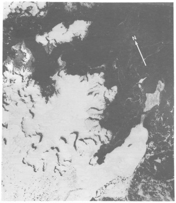
Fig.l. Mosaic of two satellite images of James Ross and Vega islands: NASA ERTS E-2740-11454 and 11461, band 4, 31 January 1977. Scale: 1 : 500 000.
James Ross and Vega islands are located on the east side of the northernmost tip of the Antarctic Peninsula (Fig. 2) James Ross Island is 77 km from north to south and 67 km from east to west; it has a total area of 2444 km2. Its highest point is Mount Haddington (1628m). Vega Island is elongated in an east-west direction, with a length of 32 km and a north-south width of 15 km. Its maximum elevation is found at Sandwich Bluff (644m). Although they are situated in the rain shadow of the Antarctic Peninsula, the islands are mostly ice-covered.
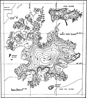
Fig.2. Glacier map of James Ross and Vega islands. Glacier numbers for this inventory are indicated. Contour interval: 100 m. Arrows indicate flow lines as suggested by contours, crevassing or field observations.
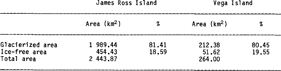
The glacierization of James Ross and Vega islands includes 138 and 29 glaciers respectively. Carlson, Persson and Lockyer islands have one glacier each. Glacier names are not given unless official names are indicated on the available maps. Classification of these 167 glaciers, their size distribution, orientation, and mean elevation are shown in Table I to Table IV. Glacierettes and river-bed snow-fields are not included in this inventory, for both scale reasons and lack of field information. Long-term stability of these snow-fields has yet to be proved. Total glacierized, and ice-free areas are given in Table V.
Table I. MODEL INPUT AND OUTPUT FOR THE THREE MODEL RUNS
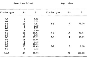
Table II. JAMES ROSS AND VEGA ISLANDS: SIZE DISTRIBUTION OF GLACIERS

Table III. JAMES ROSS AND VEGA ISLANDS: GLACIER ORIENTATION
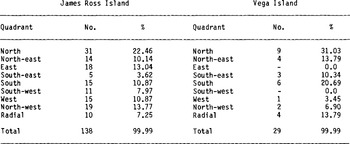
Table IV. JAMES ROSS AND VEGA ISLANDS: MEAN ELEVATION OF GLACIERS

Table V. JAMES ROSS AND VEGA ISLANDS: GLACIERIZED, ICE-FREE, AND TOTAL AREAS
This study has shown that many different types of glaciers are found on the islands. James Ross Island is dominated by a large ice field which covers most of the southern part of the island and feeds a great number of outlet glaciers, most of them moving down deep gorges excavated in bedrock. Smaller ice bodies of mountain and valley types, and some minor ice caps with radial flow are found in the north and north-west of the island. A highly crevassed, partially disintegrated ice shelf extends from the peninsula to the south-west coast.
The land ice of Vega Island consists of four ice caps with protruding rocky cliffs and nunataks that clearly dissect their catchments. Each of these ice caps has its own outlet glaciers, most of them calving into the sea. The James Ross Island ice field (IJR 138) extends over almost the entire southern part of the island. This ice body has been defined following TTS instructions (Reference MUller, Caflisch and MUllerMiiller and others 1977: 13) as an ice field. However, according to Reference Armstrong, Roberts and SwithinbankArmstrong and others (1966: 22), it could be called an ice cap (i.e.a dome-shaped glacier usually covering a highland area). Radio echo-sounding profiles show that dissected topography is buried beneath the ice; thus, we have preferred to use the term ice field and retain the term ice cap for smaller ice bodies.
On the upper central part of the ice field, three ice domes have been identified : Mt Haddington, Dome D, and Dome N, separated 3 to 4 km from each other. Mt Haddington has a gentle slope towards the west but is much steeper eastwards; domes D and N have a more regular shape. These ice features were also identified on Landsat imagery. At the summit of Dome D in 1981 a continuous core was recovered from a depth of 155 m (IAA-Laboratoire de Glaciologie (Grenoble) joint project). The area of the ice field is approximately 587 km2 and it discharges mainly through vertical ice cliffsatan estimated altitude of 700 to 800 m. The thickness of the ice at these cliffs ranges from 50 to 80 m. Some data on thickness of the ice field are available as a result of a joint British Antarctic Survey-IAA radio echo-sounding project. The thickness profile reveals that the highest rock elevation under the ice corresponds to the maximum elevation of the ice field (region of the three ice-domes). The average thickness of the ice field is estimated at 200 m and according to the profiles, the ice in the vicinity of Dome D may be approximately 300 m thick.
Acknowledgement
The authors are greatly indebted to the Fuerza Aerea Argentina for logistic support in Antarctica.


