


INTRODUCTION
In November 2019, the authors conducted a field inspection plotting the route of the Roman aqueduct supplying Knossos using a handheld Trimble GPS station and a series of 1:5000 Hellenic Military Geographical Service Maps ahead of a planned drone study. The subject of the 2019 field inspection was the long-distance water supply for Roman Knossos, mapping its route and documenting any measures taken to secure the delivery of this water to the Roman city. Our fieldwork builds on solid foundations laid by Strataridaki, Chalkiadakis and Gigourtakis (Reference Strataridaki, Chalkiadakis and Gigourtakis2009), who conducted a partial survey of the Roman aqueduct, locating the water conveyance tunnel at Skalani. We provide the first GIS map of the complete route of the Roman aqueduct, adding both elevations and physical length to the aqueduct's known trajectory. We mapped, for example, a previously undocumented 2.19 km stretch of aqueduct running from below the tunnel exit at Ampela to the upper reaches of the Spilia Spur (i.e. Walking Route 2, henceforth WR2, on Fig. 1).Footnote 1

Fig. 1. Aqueduct course showing Walking Routes.
On the Roman aqueduct's final approach to Knossos, from west of the Spilia Bridge, our documentation benefitted from the fieldwork of Susan Walker and Richard Jones, undertaken in 1976 as part of the Reference Hood and Smyth1981 Knossos Survey (henceforth KS). They reported the Roman aqueduct at the following positions (listed in reverse order from west of the bridge): KS 353–346, 319, 318, 217, 191, 188, 168 and 160, fig. 31. With a few notable exceptions, these tracts were re-identified in 2019; we could not reproduce, however, the circumnavigation of the Lower Gypsadhes plotted by the 1981 KS, as tracts KS 347, 346 and 318 were not located in 2019, which was perhaps to be expected as they were all originally reported as sub-surface features.
The route as plotted in 2019
The route of the free-flow aqueduct systems, from Fundana to Knossos, runs from the Fundana spring to the tunnel entrance at Skalani (crossing at least one bridge en route) (see WR1 on Fig. 1), through a Roman tunnel which extends over 1 km from Skalani to Ampela; from below Ampela, crossing two small bridges on a roughly northerly route before rounding the Spilia Spur (WR2); the channel then crossed the Katsambas River, turning north to follow the eastern contours of the Upper Gypsadhes hill before approaching Caronissi (WR3); from there, the aqueducts reportedly track the country road northwards towards Knossos village (Bougada Metochi) (WR4 on Fig. 1).
A note on gradient
Through careful planning, the Roman aqueduct supplying Knossos used the natural terrain to attain its necessary height, largely dispensing with the need to construct elevated walling; a measure which would have reduced costs and facilitated speedy completion. The walls of both systems supplied by the Fundana spring, the Roman and Ottoman-Egyptian, were not unduly elevated and were constructed using the natural stone encountered en route. The inverted siphon bridge at Spilia represents a marked departure, where this monument to structural engineering dominated traffic along the roadways and the Katsambas river valley running downstream from Epano Archanes.
Gradients along aqueducts are never uniform over their entire lengths; the Eifel aqueduct has slopes ranging from as low as 0.1 per cent to drops as steep as 10 per cent (Hoffman et al. Reference Hoffmann, Kummer, Márquez and Valdivia Manchego2019, 2354, fig. 3). Hodge (Reference Hodge1992, 218), however, observed ‘usual’ average gradients between 0.15 per cent and 0.3 per cent. The slope from Fundana to the higher contours of Spilia is 0.2 per cent or 0.1° (with a run of 8.24 km and a drop of 14 m, or a drop of 1 m every 588 m). This means that the Roman aqueduct operates on an average slope of 0.2 per cent for about 66 per cent of its length of 12.42 km.
The Roman aqueduct of Knossos can perhaps be viewed as an aqueduct running on two different levels, with a considerable drop separating the two, identified at Spilia. A lower course starts directly west of the crossing at Spilia at a level of 137 m above mean sea level (henceforth amsl) and runs to just above Knossos village (Bougada Metochi) along a contour of c. 115 m amsl (although it is difficult to track on its final leg). Along this lower route of just over 4 km, the gradient may be 0.55 per cent (0.3°), or 1 m every 181 m.
The drop along the Roman aqueduct's entire length of 12.42 km is c. 60 m, and if the slope were consistent, this presents an average slope of roughly 0.48 per cent (or 0.28°), meaning that the aqueduct would drop approximately 1 m in every 207 m. Lewis (Reference Lewis2001, 173, table 9.1) presented a comparable average slope for the aqueduct of Corinth at 0.5 per cent while that at Mytilene measured 1 per cent. But if the Roman aqueduct of Knossos has an overall slope of 0.48 per cent, almost half of the fall occurs at Spilia.
Background
Before proceeding, a basic definition of an aqueduct is useful for understanding our survey methodology and our approach to our field study. An aqueduct is essentially an architectural scaffold to facilitate hydraulic movement directed to a certain point at a sufficient height. Its ingenuity lies not in its monumentality but in its functionality. Roman aqueduct systems operated on the premise of constant hydraulic motion whereby movement was sustained by gravity. This gravitational movement could be interrupted, but once resumed, followed the same gravitational principles. An aqueduct's functional design is closely correlated with its associated geology and orography and it frequently forms a seam within the natural contours of the terrain. Aqueducts built along valley contours afford the easiest, most economical and rapidly executed constructions, as they avail themselves of the naturally gently sloping valley contours to maintain their required height. Valley contours running between the water source and the site to be supplied are ideal for aqueduct construction, and in this regard, the topography of Crete lends itself to the construction of gravity flow systems along valley contours (Kelly Reference Kelly and Wiplinger2006, 320). The natural declivities within the Cretan landscape facilitated the construction of cost-effective low-profile aqueducts to convey water from numerous upland springs to low-lying (or at least, lower-lying) Roman cities.
The Roman aqueducts of Crete generally consist of contour channels supported on low-profile walling descending gently along river valleys. Second storeys have only been put forward for two Roman aqueduct bridges in Crete: the bridge to the north of the acropolis at Gortyna (as tentatively suggested by Taramelli Reference Taramelli1902, 136–7) and at Xerokamares 2 along the Chersonisos aqueduct (Oikonomakis Reference Oikonomakis1986, 74). Equally, water conveyance tunnels have only been securely identified along four aqueducts on Crete (Knossos, Chersonisos, Eleutherna and Polyrrhenia), of which that serving Knossos is by far the longest (see Table 1). In Crete, whenever possible, meandering contour-line construction was favoured over the extensive bridging and tunnelling otherwise required for more direct courses. In 2019, our walking route tracked the trajectory of the Roman aqueduct of Knossos from the Fundana springs to the upper village of Knossos (Bougada Metochi) (Fig. 1), and despite the direct distance of about 6.5 km from source to destination, the Roman aqueduct's trajectory measured 12.42 km, meandering along the valley contours to maintain its functional gradient.
Table 1. Water conveyance tunnels mentioned in the text (listed in descending order of tunnel length).

The reuse of the Roman aqueduct
The historic record documents that when Crete had been ceded to Egypt (1830–40), Mehmet Ali (Ottoman governor of Egypt 1805–48) commissioned the construction of an aqueduct delivering the Fundana spring water to Iraklio. This project was completed under the supervision of Mustafa Naïli Pasha (Giritli Mustafa Pasha). John Bowring, the English Consul in Egypt, officially reported that construction was underway in 1838 (Bowring Reference Bowring1840, 162). It is relevant that construction on the nineteenth-century aqueduct was described as ‘reconstruire’ by Raulin (Reference Raulin1867, 58) and again as repairs and refurbishments by both Ralegh Radford (1937, 6 n. 10) and Rashed (Reference Rashed1978, 113) “ἐπεσκευάσθη ἠ μάλλον ἀνεκαινίσθη” (‘it was built or rather refurbished’). Rashed specified that the repair work was carried out by the Egyptian army, although she attributed the original work wholly to Morosini.Footnote 2 In Bougie/Saldae in Algeria a similar reuse has been documented, where the city's Roman aqueduct, including its tunnel at El Habel (east of the Roman arcade at Ifran, Toudja), served as a type of blueprint for an aqueduct built in 1895/6 by the French army stationed there (Cuomo Reference Cuomo2011, 157–8 n. 76). In 1896, the Roman inscription of Nonius Datus was fitted with a new panel listing both the civic administrators and the military engineers responsible for the new aqueduct, and the inscription was unveiled in its new location, outside of the townhall in Bougie, during the aqueduct's inauguration (Cuomo Reference Cuomo2011, 158).
We see the reuse of civic aqueduct trajectories at other major centres on Crete. Repair to sections of the Roman aqueduct of Gortyna, notably its inverted siphon bridge, points to its continued (re)use into the Late Antique period (Giorgi Reference Giorgi2016, 63–5). Other overlays were detected along the later aqueducts at both Chania and Rethymno (Gerola Reference Gerola1932–40, 28 and 33; Androvitsanea Reference Androvitsanea2018) but also probably occurred at Souia and Axos.Footnote 3
In 2019, our fieldwork identified the Roman channel underlying the nineteenth-century aqueduct's wall elevations along much of its length. For example, as the aqueduct approaches the tunnel at Skalani, the Roman channel is visible protruding from the base of the nineteenth-century aqueduct wall, where the Roman horizon rests 40 cm below the top of the later wall. The Roman character of this underlying construction was confirmed by thick coatings of opus signinum lining the channel, observed sporadically from Fundana to Spilia, but perhaps best demonstrated along the base of the wall in Artemis Kokkinou's garden, just north-west of Ampela Bridge 2 (marked in WR2 on Figs 1 and 2) and along the upper north-west slope of the Spilia Spur, overlooking the Spilia Bridge from the east (Fig. 3).Footnote 4 The Roman channel effectively served as a footing for the nineteenth-century aqueduct wall and provided a reference point for the additional height needed to support the later water channel while also serving as a blueprint for its trajectory. The later construction clearly damaged the Roman aqueduct, exposing its central channel. In many sections, only the opus signinum coating of the Roman channel survives, and the Roman wall is missing below this horizon (Fig. 3). This survival points to both the robustness of the channel's opus signinum and the friability of the Roman mortared wall that originally supported it.Footnote 5

Fig. 2. Roman channel (the Roman horizon marked by arrows) along base of the nineteenth-century wall, in Artemis Kokkinou's garden.

Fig. 3. Detail of opus signinum lining Roman channel at the base of the nineteenth-century wall, upper north-west side of Spilia Spur (east of the Katsambas River).
Characteristic nineteenth-century aqueduct wall facing along the aqueduct
It was not only the opus signinum seam which aided our distinction between the Roman system and the nineteenth-century aqueduct wall built over it; we also recognised a consistent style of wall facing used in the nineteenth-century aqueduct elevations. This later wall facing consisted of roughly cut larger stones, set in mortar, surrounded by smaller chinking stones (Fig. 4).

Fig. 4. Detail of nineteenth-century wall facing (south face), west of Spilia Bridge.
We first documented this distinctive nineteenth-century facing at the Fundana spring, in the wall abutted by the cement steps leading down to the chapel of Agios Nikolaos. The facing was consistently used along the aqueduct's elevations between Fundana and Caronissi but is perhaps best displayed in the particularly elevated aqueduct wall immediately west of the two-tiered nineteenth-century inverted siphon bridge at Spilia (Fig. 4).Footnote 6 The continuous length and elevation of the nineteenth-century wall here (rising to a height of 4.7 m at the edge of the ravine) necessitated some sort of throughway, and it is pierced by a curved arched doorway, measuring 1.3 m high by 0.6 m wide, with a wall width of 2.90 m (Fig. 5, the doorway is marked by the arrow).

Fig. 5. Elevated nineteenth-century wall, west of Spilia Bridge, doorway marked by arrow.
The architectural sequencing agrees with references to an Ottoman-Egyptian overlay of the Roman aqueduct observed by Giuseppe Gerola at the start of the twentieth century when he claimed that the later system (Gerola's opera turca) followed a Roman blueprint (Gerola Reference Gerola1932–40, 24; Spanakis Reference Spanakis1981, 91–2). It also complements Strataridaki, Chalkiadakis and Gigourtakis’ (Reference Strataridaki, Chalkiadakis and Gigourtakis2009, 2, 4 nn. 29–30, pls 8–9) interpretation of pitched roof slabs immediately inside the Skalani tunnel entrance as Ottoman-Egyptian work.Footnote 7
Locating the source
In Reference Hood and Smyth1981, Hood and Smyth claimed that the source of the Roman aqueduct of Knossos had ‘not yet been identified’ (p. 23). Gerola (Reference Gerola1932–40, 24), however, reported that the Roman aqueduct of Knossos tapped the spring at ‘Fundána’, as subsequently reiterated by Roberts (Reference Roberts1979, 239) and Spanakis (Reference Spanakis1981, 24, 92). More recently, the Fundana spring was re-identified by Strataridaki, Chalkiadakis and Gigourtakis (Reference Strataridaki, Chalkiadakis and Gigourtakis2009, 1) just north of Kounavi village.
In terms of gravity-flow conduction towards the Roman city of Knossos, the topography is most suitable from the springs along the northernmost foothills of Juktas, something Evans (Reference Evans1903–4, 52–3) was aware of at the start of the twentieth century. The natural valleys descending northward from these foothills facilitated gravity-flow conduction towards the Roman city, where, despite incorporating an acropolis rising to over c. 170 m, with considerable spreads of Roman material extending to its summit, most identified domestic architecture (to date) occurs below c. 115 m amsl.
When on-site springs could no longer meet the growing urban demand of Romanising communities, water had to be brought into settlements and cities at an adequate height to serve specific amenities (notably baths and public fountains) (Giorgi Reference Giorgi, Camporeale, Dessales and Pizzo2010, 420). Even when an abundant, but lower, spring existed closer to hand, a source higher in the hills was often tapped by Roman aqueduct surveyors, as sufficient spring altitude underpinned optimal gravity-flow conduction to the destination site and its amenities. In his report of 1629, Morosini emphasises that it was not only the abundance of the springs at Karydaki, but their considerable height above the city (120 passa geometrici Footnote 8 higher than it) that made them the most suitable source for the aqueduct of Candia (Iraklio) (Moresini, Relazione n. 12, in Spanakis Reference Spanakis1950, 28).
At Nicomedia, Pliny recommended an elevated arcade for the aqueduct's approach to the city so that its service might not be restricted to the lower zones (Pliny, Letters 10.37). That is not to say that lower springs were ignored by locals, and they continued to be used (alongside wells and rainwater cisterns), albeit often for different purposes.Footnote 9 At Gortyna, Giorgi (Reference Giorgi2016, 37–9) suggested that prior to the construction of the large public thermae, on-site springs, rainwater harvesting, and the river itself may have sufficed for the earlier settlement. At Gortyna, the existence of the Roman civic aqueduct is assumed in the first century AD based on the presence of two large bathhouses (the baths in the so-called Praetorium and the Megali Porta baths), although the relatively more secure second-century AD date for the aqueduct was established through direct architectural comparison with the Megali Porta baths (Giorgi Reference Giorgi2016, 42, 61).
WALKING ROUTE 1 (WR1)
The free-flow bridge below Agios Sozontas (WR1)
Just north of the Fundana springs, the first newly documented aqueduct bridge along the trajectory is nestled in an inlet far below the church of Agios Sozontas where the 1.4 m-wide bridge deck rests at a height of c. 171 m amsl (Figs 6–7). While the bridge is marked on the ΓΥΣ map no. 9529/4, it has never been documented archaeologically as part of the aqueduct system. The bridge consists of a single central arch, 3.8 m wide by 5 m high, defined by finely cut voussoirs. The bridge deck containing the water channel sits 6 m above the riverbed. A rock-cut settling tank facilitated the aqueduct's abrupt angle to the north, suggesting that the aqueduct bridge was originally designed as a free-flow system (Fig. 7). It is probable that this small tank had some form of sluice gate for regulations and to allow repair to the bridge channel (see Chanson Reference Chanson2002, 46–8).

Fig. 6. Walking Route 1 Fundana to Skalani.

Fig. 7. Rock-cut tank at south end (i.e. the start) of the Agios Sozontas Bridge (with metal pipe embedded in bridging channel).
While the bridge was very overgrown in 2019, protruding ledges were detected at the base of nineteenth-century walling leading up to, and away from, the bridge. Opus signinum lined the ledge protruding from the wall immediately north of the bridge (Figs 8 and 9).

Fig. 8. Nineteenth-century aqueduct wall along north side of bridged inlet, arrows mark protruding ledge of the Roman aqueduct (photographer facing west).

Fig. 9. Opus signinum along the protruding ledge of the Roman aqueduct along base of nineteenth-century wall, north of bridged inlet.
A missing bridge at Skalani (WR1)
On its run up to the tunnel entrance at Skalani, the aqueduct wall disappeared at a direct distance of 320 m south-east of the tunnel entrance (see Fig. 6). This gap presents an unusual hiatus, in that it is the largest gap between documented remains along WR1. On approaching the tunnel, our last sighting of the aqueduct wall (both Roman and nineteenth century) sits at a height of 169.9 m amsl, while the tunnel entrance rests at an elevation of 168.5 m amsl. When we ran a line from our last sighting of the aqueduct wall to the tunnel entrance, the ground dropped by c. 7.5 m (i.e. from 169.9 to 162.4 m) below this projected line towards a rivulet running north-east towards Agios Minas, making this the probable location of an elevated structure (Fig. 6). The hiatus in our mapped aqueduct trajectory, together with the drop in ground level below the aqueduct's necessary height here, makes this the most suitable location for an aqueduct bridge, which was blown up near Skalani in the 1897 Revolution, as we know from a letter sent in April that year from British Colonel Sir Herbert Chermside to Antonios Trifopoulos (IAA no. 196, cited in Strataridaki, Chalkiadakis and Gigourtakis Reference Strataridaki, Chalkiadakis and Gigourtakis2009, 5, n. 39).
The Roman aqueduct tunnel
Spanakis (Reference Spanakis1981, 24, 92) reported that a tunnel at Skalani extended for over 1 km. In 2009, Strataridaki's team relocated the entrance of the Roman aqueduct tunnel, just south of Skalani (Strataridaki, Chalkiadakis and Gigourtakis Reference Strataridaki, Chalkiadakis and Gigourtakis2009, 2, 4, nn. 29–30, pls 8–9). The interior of the tunnel, measuring 1.7 m–2 m high by 0.75 m wide, is brick lined and vaulted. The brick is 5 cm thick (vertically), with horizontal lengths of 30 cm. The mortar joint is 2 cm thick. About 40–50 cm above the ground, a horizontal seam of sinter seems to define the channel; 85 cm above this, another ledge, 7 cm wide, marks the spring of the vault, which rises another 40 cm. The brickwork of the introdos of the barrel vault alternates along its length: radial brick crowned with a central seam along the apex is visible just beyond the entrance, which gives way to vertically laid brickwork springing from four radial brick courses above the spring of the arch. The brickwork is comparable to that of the service corridors of Bath A in Argos, which is viewed as Hadrianic.Footnote 10
The tunnel runs on a roughly west–east 275° bearing for over 1 km and functioned as a gravity-flow water conveyance system (Fig. 10). The terrain only drops to an elevation below that of the tunnel entrance (i.e. 168.5 m amsl) in this direction in the Ampela area, where the tunnel exit was discovered between the Knossos–Charakas road and a small tributary stream. From its entry point of 168.5 m amsl, the tunnel burrows through a hill rising to 244.6 m over its trajectory, effectively traveling c. 75 m below the ground surface at its mid-point. In laying out the tunnel, the surveyors perhaps strategically avoided more extensive spreads of elevated terrain immediately north and north-west of the tunnel entrance. The tunnel's final axis and trajectory resulted from an appraisal of the shortest underground trajectory possible for gravity flow in the direction of Roman Knossos. Roman engineers clearly deemed the tunnelling project at Skalani–Ampela a reasonable investment of both time and labour to secure the civic water supply of Knossos; the main benefit driving such a challenging boring project was access to the most abundant spring in the region, that at Fundana.

Fig. 10. Interior of the Skalani–Ampela tunnel, photographer facing west.
The tunnel is impressively straight for nearly half its length, at which point some angling is apparent.Footnote 11 The tunnel has at least six shafts (Stelios Manolioudis and Manolis Afrathianakis pers. comm.), the first of which is encountered 135 m from the entrance. At this juncture, the passage widens to form a circular ground plan, with a diameter of 1.20 m (reflecting the size of the vertical shaft) (Fig. 10). The area just below this, and every subsequent, shaft is revetted with stonework. While Hero of Alexandria had already outlined the theorem and methodology for boring through a mountain from two given points in the first century AD (Hero Dioptra 15; Lewis Reference Lewis2001, 273–4), Roman tunnelling projects could still go wrong.Footnote 12 An inscription discovered at Lambaesis (modern Tazoult in Algeria) informs the reader that a second-century AD tunnelling project along the Saldae aqueduct (referenced above) had gone awry, to the point of near abandonment, when it was discovered that the excavation work conducted simultaneously from both ends of a mountain was longer than the width of that mountain (Cuomo Reference Cuomo2011, 145; CIL VIII 2728). The El Habel tunnel along the Saldae aqueduct burrows 86 m below a ridge to the west of Ifran, presenting a challenging depth for sinking shafts (although shafts along qanats have been sunk to over three times this depth).Footnote 13
The water conveyance tunnel at Skalani–Ampela is nearly twice as long as the notorious Saldae tunnel (see Table 1). The water tunnel serving Roman Knossos burrowed far deeper and for far longer than any other Roman water tunnels on Crete (see Table 1 for comparisons). It is five times longer than the Chersonisos tunnel, which only travels c. 5 m below ground surface, although Oikonomakis (Reference Oikonomakis1986, 52, 56, 61) was unable to examine its interior as it was half-filled with earth. It is also 26 times longer than the Eleutherna tunnel, which travels at a depth of c. 10 m below ground surface, emerging on an elevated eastern scarp on the city's acropolis (Sarris et al. Reference Sarris, Papadopoulos, Cantoro, Agapiou, Déderix, Tsigonaki and Devolder2015, 695). Water tunnels in Crete also differ in form and finish: at Eleutherna, the unlined tunnel walls wind back into the bedrock, as opposed to the linear trajectory of the brick-faced interior of the Skalani–Ampela tunnel. The tunnels curving into the bedrock at Polyrrhenia have been dated to the Classical or Hellenistic periods.Footnote 14
In terms of field study, pinpointing the tunnel entrance at Skalani established a fixed point which could then be used as a double-check for our plotted trajectory up to this point (Fig. 1). The entrance of the water tunnel lies at an altitude of 168.5 m amsl, and in order for the system to function, water had to be channelled along a gentle gradient from a spring to that location. The only spring situated at a sufficient height and suitable situation to reach the tunnel entrance is that of Fundana (at an altitude of 175 m amsl). A simple exercise of projecting a line of gentle gradient from the tunnel entrance back to the spring allowed us to map a fairly accurate aqueduct trajectory running along a slope of 0.129 per cent or 0.07° (with a rise 6.5 m and a run of 5025 m) (covering WR1; Fig. 6). Along this 5.02 km stretch, the average gradient is 1/773, comparable to the average fall along the Gier aqueduct feeding Lugdunum (modern Lyon) in Gaul at 1/725, and that along a section of the Eifel aqueduct approaching the Swist Fault system (Hoffman et al. Reference Hoffmann, Kummer, Márquez and Valdivia Manchego2019, 2354, fig. 3). The altitude and position of the Skalani–Ampela tunnel entrance, the Roman construction date of the tunnel and its reuse in the nineteenth century demonstrate (without the need for any further fieldwork) that the spring at Fundana was tapped by both systems, almost two millennia apart.
WALKING ROUTE 2 (WR2)
We plotted a 2.19 km stretch of aqueduct running from below the tunnel exit at Ampela to the upper reaches of the Spilia Spur (WR2, on Fig. 1). This section of the aqueduct had not been documented before our fieldwork (see Strataridaki, Chalkiadakis and Gigourtakis Reference Strataridaki, Chalkiadakis and Gigourtakis2009, 3).
Ampela Bridge 1 (WR2)
Below the tunnel exit (at c. 163–4 m amsl), the nineteenth-century aqueduct wall leads northwards towards the first of two bridges. About 140 m north of the tunnel exit, the aqueduct crosses a south–north flowing rivulet on a single arched free-flow bridge (Fig. 11). Prior to 2019, this aqueduct bridge had not been identified as part of the aqueduct system, although a bridge is marked in this spot on ΓΥΣ map no. 9529/2. The aqueduct wall leading up to the bridge is 1.10 m wide but the bridge deck, resting at 161 m amsl, widens to 2.38 m. The increased thickness of the bridge, and a cross wall rising from the western end of the bridge deck, suggests that the water bridge may also have served as a footbridge.

Fig. 11. Walking Route 2 Ampela to Spilia.
Although the bridge elevations display characteristic nineteenth-century facing, the rivulet is heavily silted up and only the upper portion of the bridge is currently visible (Fig. 12). The arch rib is defined by finely dressed sandstone voussoirs, measuring, on average, 25 cm by 25 cm by 50–60 cm long, with smooth fitted radial joints, finely convex soffits and roughly shaped upper surfaces. The voussoirs of both Ampela bridges are similar in stone type, dimension, fitting and finish.
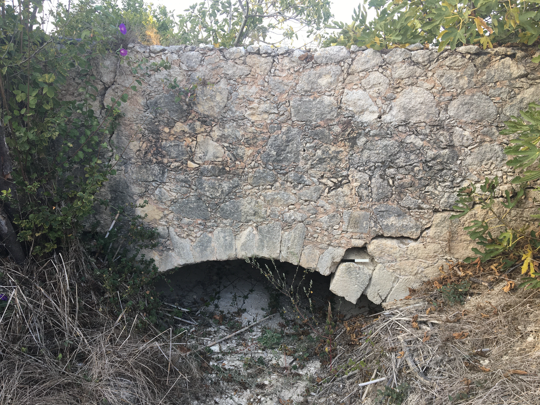
Fig. 12. Ampela Bridge 1, south face. Note crack and slipped voussoirs along right side.
Ampela Bridge 2 (WR2)
Moving north along the west side of the rivulet, another aqueduct bridge was recorded (at the first modern house along WR2), where the ground dips down to meet a tributary stream (Fig. 11). Again here, the bridge deck is a wider structure than the aqueduct wall leading up to, and effectively abutting, it. The aqueduct bridge had not been previously documented archaeologically as part of the water supply system, but the bridge is marked on ΓΥΣ map no. 9529/2. This aqueduct bridge (Fig. 13), with its finely dressed sandstone voussoirs defining a single arch spanning 2 m, is very similar to Ampela Bridge 1.

Fig. 13. Ampela Bridge 2, west face.
The axis of the bridge follows a bearing of 290° south-east–north-west. Immediately north of the bridge, the aqueduct wall changes direction, angling 20° to follow a bearing of 310°, while 14.1 m further along its course, the wall angles to the north-west following a bearing of 270°. The join at the first angle features a misalignment in the lower tier of the wall, but this is rectified in the upper tier. This two-tiered joinery suggests a phasing in the construction of the height of the wall while the misalignment at the lower level at the edge of the bridge also suggests that two teams operated at ground level: one responsible for building the arch of the bridge, perhaps a specialist crew, and another charged with general wall construction.Footnote 15 The wall elevation at Ampela 2, rising to almost 3 m, displays characteristic nineteenth-century facing; however, it is tempting to see an earlier phase to this bridge's architectural foundation, but both bridges are heavily silted up.Footnote 16
The Roman aqueduct on either side of the Katsambas River at Spilia
The next waterway to be bridged – the Katsambas River – presented a more serious obstacle for the aqueducts’ progression. At either side of the ravine at Spilia, stretches of the Roman channel lined with opus signinum were identified (Figs 3 and 14 on the east, and Figs 15–16 on the west). Remains of the Roman aqueduct on the east and west sides of the river are interrupted by a dramatic fall of 24 m (resting at 161 m amsl to the east and 136–7 m amsl on the west side of the river). The opus signinum in both sections identifies the two tracts as Roman, despite the dramatic drop separating them.Footnote 17

Fig. 14. Detail of opus signinum lining Roman channel at the base of the nineteenth-century wall, upper north-west side of Spilia Spur (east of the Spilia Bridge/Katsambas River).

Fig. 15. Roman aqueduct wall and channel (foreground), nineteenth-century walling in background (north face), west of Spilia Bridge/Katsambas River.

Fig. 16. Free-standing Roman aqueduct wall, west of Spilia Bridge/Katsambas River.
For the first time along its route from Fundana, the Roman aqueduct wall is free-standing immediately west of the Spilia Bridge (KS 353) and the Roman line is no longer directly overlaid by the nineteenth-century system. The 1.65 m-wide free-standing Roman aqueduct wall survives in its entirety here, demonstrating the degree of destruction caused by direct overlay up to this point (Fig. 16). The two aqueducts diverge here, with the later aqueduct adhering to the higher ground traversing the crest of the hill to the west-south-west and the Roman aqueduct following an east–west running contour below this for a length of 35 m (Fig. 16).Footnote 18 The Roman wall supports a 0.40 m-wide channel, which rests on a series of bipedales, seen here for the first time along the aqueduct's route.Footnote 19 The Roman channel is lined with a 10 cm-thick coating of opus signinum incorporating corner bevels.
That Roman walling lined with opus signinum runs up to, and away from, this point on either side of the valley suggests that the Roman aqueduct crossed the river in the same location as the nineteenth-century Spilia bridge.Footnote 20 If this is the case, how the Roman system facilitated such a dramatic drop remains unknown at this point. It is possible that the Roman aqueduct did not use an inverted siphon to cross the river; instead, we might envisage a chute or cascade facilitating a lowering of the water level on the east side of the river, from where the water could be channelled across the river on a free flow bridge. Sizable chunks of mortared Roman masonry (incorporating wall elevations and a partial floor foundation) were identified on the north-west slope of the Spilia Spur about 3 m above the modern roadway (marked RM on Fig. 11). This structure could theoretically have served as a water dropping device or chute; various structural devices, including chutes, cascades, and dropshafts, facilitated drops in height along free-flow channels, as outlined by Chanson (Reference Chanson2000; Reference Chanson2002; see also Lewis Reference Lewis1999, 153). The Brévenne aqueduct at Lyon, for example, has a longitudinal gradient of about 0.4 per cent to 1.25 per cent, but the gradient is made up of gently flowing tracts broken up by a series of steep chutes (Chanson Reference Chanson2000, 67, table 1, fig. 19; Reference Chanson2002, 44).
The nineteenth-century bridge at Spilia
The inverted siphon system at Spilia, replete with its two-tiered venter bridge (Fig. 17), was constructed in 1838 (Bowring Reference Bowring1840, 162), reportedly under the supervision of local foreman Theodoraki Georgiadis or Koutagiotis from the village of Agios Thomas.Footnote 21 While the inverted siphon at Spilia constitutes a nineteenth-century construction, pressurised systems, including inverted siphon technology, were widely applied along Roman aqueducts.Footnote 22

Fig. 17. Venter bridge at Spilia, south façade (Fondo Giuseppe Gerola, Copyright Istituto Veneto di Scienze, Lettere ed Arti, all rights reserved).
The inverted siphon at Spilia is a massive structure; if we include the adjacent descending and ascending wings, the bridging structure is 186.6 m long. A gallery quarry has been identified along the west side of the Spilia Spur, with further traces of quarrying along scarps to the south of the bridge on both sides of the valley (Todd Whitelaw pers. comm.), although whether these were opened for the bridge's construction is unclear. The start of the inverted siphon structure at Spilia is now marked by a cemented header tank, from which the outflow pipe rests at an elevation of 147.5 m amsl. But it is important to remember that the water (in both systems) began its descent from higher up on the Spilia Spur at an altitude of 161 m amsl, representing a drop of c. 13 m before reaching the nineteenth-century inverted siphon structure. From the tank, pipes descended to the bridge deck, which sits at a height of 130.9 m amsl, constituting another drop of 16.6 m. The drop from the aqueduct rounding the summit of Spilia to the deck of the venter bridge is c. 30 m.
In an inverted siphon system, free-flow can only resume at some point below the height recorded at the start of the inverted siphon, a point usually marked by a header tank, but, at Spilia, the absence of a receiving tank on the opposite western brink of the ravine suggests that the full extent of the inverted siphon lies further west. The height of the immediate ascent on the far side of the river only reaches c. 142 m amsl, and the channel elevation continues to climb, albeit more gently until it reaches a now-ruined mansion (marked on ΓΥΣ map 9529/2 280 m west of the header tank) where the channel sits at 144 m amsl. That inverted siphons could transport water for considerable distances can be seen elsewhere on Crete, in the inverted siphon supplying Roman Lyttos which extended for about a kilometre, initially following a 310° bearing north-north-west, but incorporating a 40° angle west-north-west about 500 m along its length, before the aqueduct turns northward to reach the city (Kelly Reference Kelly, Aristodemou and Tassios2018, 164). Burdy (Reference Burdy2001, 40, table 1) recorded lengths of inverted siphons along the Gier aqueduct of Lyon extending to 575 m (Trion), 700 m (Durèze), 1210 m (le Garon) and 2660 m (Yzeron) with venter bridge lengths of 136 m (Durèze), 210 m (Garon) and 270 m (Yzeron) (see also Kessener Reference Kessener2022, table 4).
At Spilia, pressure in the nineteenth-century inverted siphon was relieved by a two-storey venter bridge. The deck, containing the water conduit (fitted with pipes), crosses the river at a height of 130.9 m–129.9 m amsl (Fig. 17). The lower storey of the venter bridge consists of a single curved arch spanning the riverbed, with its apex directly above the riverbed below (see also British School at Athens Society for the Promotion of Hellenic Studies Image Collection 01/3913.7601). The second storey stands on a 6.3 m-wide foundation and accommodates four pointed arches: a large arch (16.6 m wide by 4 m deep) positioned directly over the main curved arch of the lower storey spanning the river, a roadway arch and two smaller relief window arches. The first storey rises to the height of the modern road; this roadway passes through a pointed arch (6.8 m wide and 4 m deep) in the bridge's second storey. The potential antiquity of this routeway along the river was noted by Evans (Reference Evans1928, 62). The arches at Spilia are all architecturally functional, serving to relieve weight, while also allowing the river and road to pass through the structure. The double window arches in the upper storey, while relieving weight at a key point, are also strategically placed to break up the otherwise imposing façade between the two larger arches of the second storey, where they perhaps guard against wind and earthquake damage within such a narrow gorge.Footnote 23
WALKING ROUTE 3 (WR3)
On crossing the Katsambas River, the Venetian aqueduct descending from Karydaki joins, or shadows, the Roman system; as reported by Gerola (Reference Gerola1932–40, 24) who first noted the convergence of the aqueduct systems between the bridges of Silamos and Caronissi. In 2019, this convergence was pinpointed in the field. The Venetian aqueduct descends along the Katsambas River from which it departs just south of the village of Agia Irini. Its route is clearly marked by a zig-zag line (on maps ΓΥΣ 9529/3 and ΓΥΣ 9529/1) running from the Silamos Bridge northwards, veering north-west just south of Agia Irini village (Kelly Reference Kelly2022, 119, fig. 2, 149). On ΓΥΣ 9529/1, the zig-zag line marking the Venetian aqueduct's descent from the Silamos Bridge continues as a dotted-dash line after crossing the road leading eastward down to the village of Agia Irini. At this point, the line joins the contour marked 160 m on ΓΥΣ 9529/1 (although closer to 150 m in the field); this trajectory is delineated in the field by a wall supporting a footpath. A section of the wall's façade was recently coated with mortar obscuring the original stonework. A long stretch of this wall is visible further north, directly west of KS 351, where it again supports the footpath (KS 351 is marked on Fig. 18). This wall and the footpath itself constitute the Venetian aqueduct which runs higher than, and parallel to, Roman aqueduct tracts KS 352 and KS 351 (marked on Fig. 18).

Fig. 18. Walking Route 3 Spilia to Caronissi.
The east slopes of the Upper Gypsadhes (WR3)
Where a small depression interrupts the aqueduct's northerly trajectory, substantial tracts of mortared masonry follow a north-west course. Two substantial segments of mortared walling loop around this shallow depression. A 16 m length of mortared masonry, possibly abutting a scarp, is visible running behind a chicken coop at the back of a modern house. The wall's core is exposed, with little facing remaining. To its immediate north-west, a substantial freestanding mortared wall extending for 3.75 m may be a continuation of the wall running behind the property (Fig. 19). This short wall segment may have collapsed from the scarp as it sits at a slight tilt. If so, the entire length of this surviving stretch of walling would measure 25.6 m. This section of mortared walling has a façade of neatly cut blocks, c. 15 cm by 30 cm, laid in layers of roughly equal height. Another substantial section of mortared masonry lies within a fenced garden immediately to the west, but we could not gain access to it in 2019.
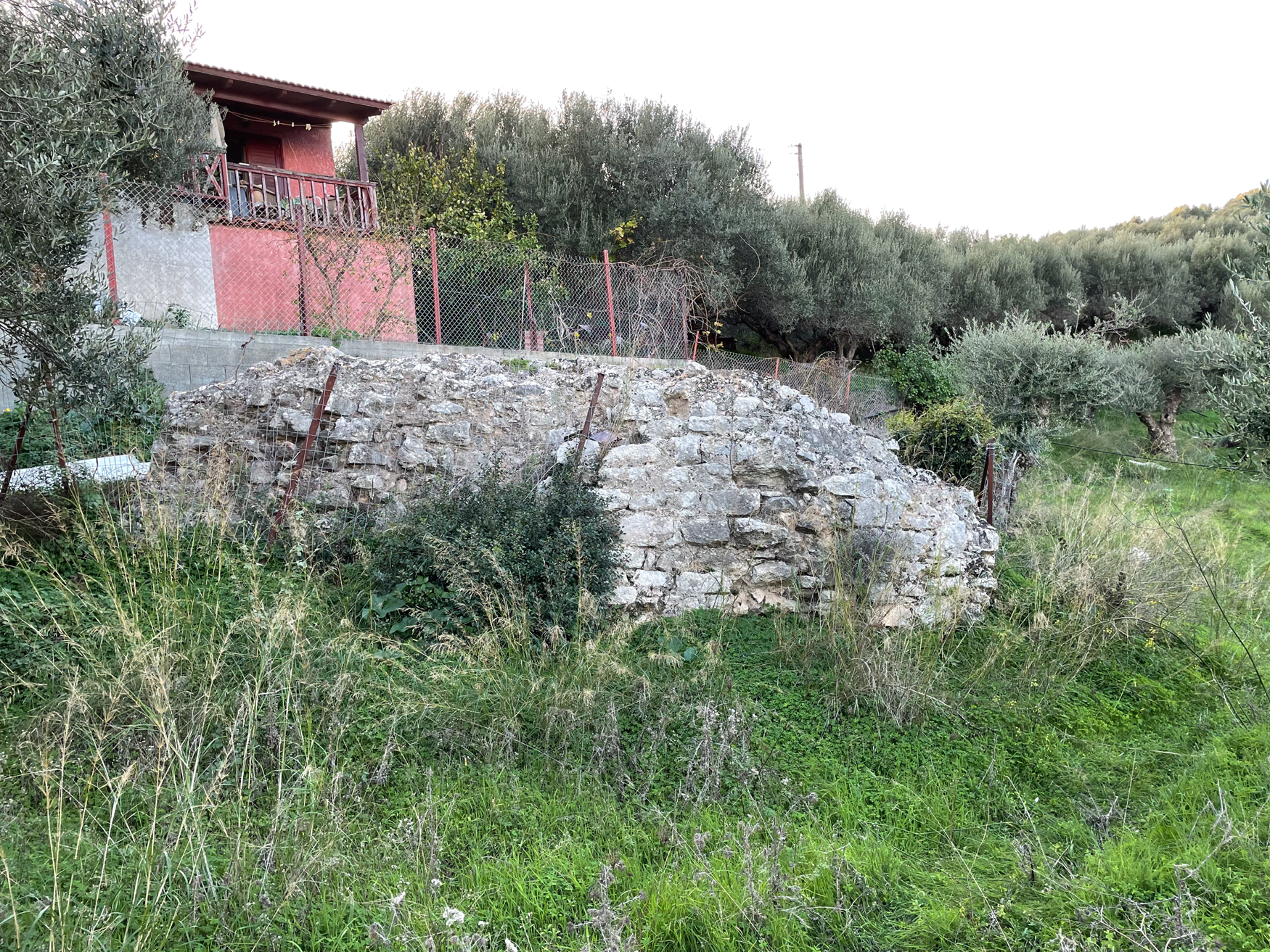
Fig. 19. Mortared masonry blockwork, possibly KS 350, photographer facing west.
This masonry most likely represents Hood and Smyth's KS 350 (marked on Fig. 18), which they described as ‘stretches of Roman aqueduct … comparatively well preserved where it was transported across a gully’ (KS 350). It is, however, unlikely, that the walling identified in 2019 represents Roman construction; its height above sea level and its neat blockwork point to a Venetian date. Roman walling studied along other sections of the aqueduct in 2019, where it did survive, was particularly friable and prone to collapse. Often only the opus signinum of the channel was found in situ, whereas the blockwork of this wall section has a strong bonding mortar. It is likely that Hood and Smyth's KS 350 represents the blockwork of the Venetian aqueduct. The Roman trajectory must be lower lying and potentially covered by soil subsidence; KS 351, 352, 347, 346 and 318 were all found below ground surface.
To the north, another sizeable free-standing fragment of mortared masonry nestled, although possibly on its side, at the foot of the steep bank below the wall supporting the footpath, presumably from where it rolled. The road sits at roughly 150 m amsl and the base of the escarpment below it sits at 131 m amsl. Further on, another square of mortared masonry, with a possible channel cut, sits at the base of the slope descending from the wall supporting the path. These sections of walling might represent Hood and Smyth's KS 349 (marked on Fig. 18), which they described as a ‘stretch of Roman aqueduct with part of the water channel intact, visible for some 10 metres in the side of a steep bank below the path … about 100 metres north of 350. The western edge of the channel has survived in places with a bevel some 0.05 metres wide at the bottom.’
The Venetian and Ottoman-Egyptian upper terrace
The Ottoman-Egyptian and Venetian aqueduct walls form parallel terraces along the eastern contours of the Upper Gypsadhes (marked on Fig. 18). The upper terrace runs from the gully (mentioned above) for 311 m and serves as a footpath, or kalderimi. At the gully, the upper terrace rises to 151 m amsl (at its south end) gently descending to 147 m amsl at its northern end.
A particularly substantial section of masonry supports the upper terrace for 19 m, although it gently diverges from the terrace for up to 4 m (Fig. 20). This tract of masonry is located at an angle north-north-west midway along the upper terrace. This supporting wall exhibits substantial blockwork and must represent Hood and Smyth's KS 348 (marked on Fig. 18), which they described as a ‘stretch of Roman aqueduct … exposed as a terrace wall some 20 metres long and standing to a maximum height of about 3 metres just below the path. Other shorter stretches are visible some 35 metres to the north and south’ (KS 348).

Fig. 20. Wall of mortared blockwork, possibly KS 348, photographer facing west.
A seam of a substantial foundation wall extends northward for at least another 14 m from KS 348 towards a culvert at the base of the wall. Another 2.66 m-long segment of mortared masonry is evident at the base of this upper terrace wall, 8.5 m further north. These remains of substantial walling supporting the upper terrace probably constitute the Venetian aqueduct, which was subsequently overlaid by the Ottoman-Egyptian aqueduct along this contour.
Between these earlier, and possibly Venetian, elevations, the upper wall supporting the terrace is faced with nineteenth-century stonework, consisting of roughly cut larger stones surrounded by smaller chinking stones laid in mortar. Further north, two phases form clear architectural horizons in the wall elevation. It seems likely that this narrow ledge or terrace originally held a water channel, probably that of the Ottoman-Egyptian aqueduct which was built directly over the wall of the Venetian aqueduct. Along the northernmost section of this narrow terrace (and close to KS 331), nineteenth-century walling is also visible above the pathway along its western edge where it presumably protected the channel.
The lower Gypsadhes loop
In 2019, we documented channels and walling turning to the west/left at the road junction, constituting a clear break from the trajectory recorded in the 1981 Knossos Survey in which the Roman aqueduct circumnavigates the Lower Gypsadhes spur (KS 346–7 and 318; marked on Fig. 18). In November 2019, we were unable to find these three tracts recorded in the Knossos Survey, as all three were originally discovered in deep cuttings or excavated trenches: KS 347 was unearthed in a trench dug for a water pipe in the 1970s;Footnote 24 KS 346 was visible in an emplacement dug in the Second World War;Footnote 25 while, in 1968, the cover slabs of KS 318 were recorded as c. 1.10 m below ground surface.Footnote 26 The fact that all three tracts lay below ground surface impeded their identification in 2019. The existence of these tracts, however, confirms that the Roman water supply ran on a lower contour than the Venetian and Ottoman-Egyptian lines along the east foothills of the Gypsadhes.
KS 347 and 346 would be relatively well placed for connectivity with a trajectory running northwards from below KS 350–348. It is also interesting that Hood referred to an early and later Roman system diverting here, the earlier looping the Lower Gypsadhes hill and the later turning west on a more direct approach to Caronissi (see Knossos Logbook 52). The detour around the Lower Gypsadhes (represented by three short tracts recorded in 1981) could be integrated in a wider appreciation of the Roman system.
A lower-lying Roman cistern was also located in the 1970s when it was exposed in a road cutting (KS 319). Hood and Smyth proposed that it was indirectly fed by aqueduct tracts KS 348–53, but this supposition is difficult to substantiate given the cistern's much lower altitude. At any rate, cistern KS 319 was a substantial double cistern, measuring 10.80 m by 5.6 m (Knossos Logbook 41–2).Footnote 27
The approach to Caronissi
In deference to the earlier reports, we must envisage a Roman tract looping the Lower Gypsadhes, but the later systems take a more direct route westward towards Caronissi. Directly north of the parallel terraces, walling was visible in the surface of the dirt road in 2019, near KS 330. A little further on, at the T-junction (just past KS 334), the walling veered west/left where it was visible along the side of the road surface. So instead of circumnavigating the Lower Gypsadhes, we plotted visible architecture turning west along the road surface.
Where the ground dips to the north-west, the walling became elevated along the roadside, incorporating a 60 cm-wide architectural ledge. As the road turns due west, descending to the Caronissi Bridge, a 40 cm-wide channel was evident in the road surface (Fig. 21). Another 40 cm-wide channel with neatly fitted limestone capstones crossed the road before its final free-standing run to the bridge; the careful stonework and neat positioning of these capstones is reminiscent of the stonework in the Venetian Caronissi Bridge (mentioned below), suggesting contemporaneity here. By 2021, the road had been resurfaced covering these particular remains (Amanda Kelly, personal observation).

Fig. 21. Channel in the road surface on descent to the Caronissi Bridge, photographer facing east.
The Caronissi Bridge
The three water systems cross the Vlychia tributary on their approach to Knossos on two bridges: the nineteenth-century system reuses the elegant Venetian free-flow Caronissi Bridge while the Roman aqueduct crosses the ravine on a bridge to its north (marked on Fig. 18).
The deck of the Caronissi Bridge sits at an elevation of 130.13–129.5 m amsl, with the riverbed resting c. 30 m below. The bridge's stonework is distinctive, consisting of neat series of regularly cut rectangular blocks, 30–80 cm in length, set in linear courses of equal height (rising to just over 20 cm). Diagonal tooling is visible on the face of the stonework, while patches of mortar coating, faintly scored by criss-crosses, are also visible.
A 60° angle to the south-west marks the aqueduct's direct approach towards the river, and from here, it runs for 117 m until it meets the modern roadway on the far side of the river.Footnote 28 At the lip of the gorge, some 42 m from the initial angle, the aqueduct incorporates a more subtle 10° angle, which lines up the bridge perpendicularly to the river. This perpendicular arrangement between bridge and river reduces the required building materials and minimises the structural vulnerability of the bridge (Hubert Chanson pers. comm.). Gerola measured the Caronissi Bridge at 54 passi long with a single arch rising to 70 piedi with a width of 30 piedi (Gerola Reference Gerola1932–40, 17, fig. 4, 18, 22, fig. 8 [showing south façade]).
A Venetian inscription, and a lion in relief, decorate the northern façade of this bridge above the apex of the arch. The inscription was published by Gerola, who noted that the text had been erased by the ‘Turchi’, so that only the first and sixth lines could then be partially detected (Reference Gerola1932–40, 378, n. 6). The name Maurocenus Franciscus (Francesco Morosini), the civil governor of Crete in that year, is legible in the first line, and the year 1627 is clear in the sixth and final line (Kelly Reference Kelly2022; Gerola Reference Gerola1932–40, 378, n. 6).
Strataridaki, Chalkiadakis and Gigourtakis, citing Stavrinidis, report that the nineteenth-century trajectory reused the Venetian bridge in the Vlychia area on its course to Iraklio.Footnote 29 This reuse is complemented by both the textual erasure but also repair work evident along the deck of the bridge, accommodating the channel, where work in small bonded stones creates a distinctive seam in the masonry. The insertion of small chinking stones around the regular blockwork and, consequently, re-grouting over them may also represent later work.
Roman bridge piers to the north of the Caronissi Bridge
A Roman bridge was recorded in the 1981 Knossos Survey as consisting of ‘concrete stumps of supports for [the] Roman aqueduct crossing the Vlikhia stream bed north of the Venetian aqueduct’ (KS 160). In 2019, a masonry block, measuring c. 4 m wide north–south, 1.5 m high and 1.5 m deep, and consisting of roughly cut mortared stone, projected from the lower western side of the riverbed (Fig. 22; see also Kelly Reference Kelly2004, vol. 1, 100, vol. 2, 32 n. 8.5, vol. 3, pl. 16a–b). Two other blocks of mortared masonry were plotted higher up on the east (117.22 m amsl) and west (118.3 m amsl, as marked by a square rock-cut cistern) banks of the river (marked on Fig. 23). The Roman mortar in these piers, and throughout the Roman system's walling, is highly friable and prone to disintegration. With only three stumps of masonry surviving, the form and operability of this aqueduct bridge remains unclear; however, the Roman bridge deck may rest at a lower level than its Venetian counterpart, which might explain the adherence of the nineteenth-century system to the Venetian course, once it encountered it along its route.

Fig. 22. Roman Bridge north of Caronissi Bridge, masonry pile on low west bank.

Fig. 23. Walking Route 4 Caronissi to Knossos village (formerly Bougada Metochi).
WALKING ROUTE 4 (WR 4)
On its final approach to the Roman city, the aqueduct was difficult to detect in 2019, although previously recorded walling was re-identified at a group of rock-cut tombs (KS 168) lining the roadway “της φασκομηλιάς” (marked on Fig. 23). In 2019, only the mortared foundations of a wall were visible in the western road scarp adjacent to these tombs near the ruined church of Agios Kirillos. This was the only walling recorded along this roadway between the bridging of the Vlychia and the Roman cistern in Knossos Village (Bougada Metochi), and even this could not be dated with confidence. A Roman cistern was, however, reported from south of this tomb and compared to cistern KS 319 (KS 168); this could not be identified in either 2019 or 2021. Due to the scarcity of Roman aqueduct remains along the roadway, it is possible that the Roman line ran parallel to, but below (i.e. to the east of), the roadway on its run up to the village.
A Roman cistern in the upper village of Knossos (Bougada Metochi)
In 1981, a Roman cistern, KS 191, was reported in the upper village of Knossos (formerly Bougada Metochi). At that time, the remaining architecture measured 8 m north–south by 1.35 m, and while no corners were mentioned, reports of a bevelled edge indicate the angle along one side of the flooring. Hood and Smyth described KS 191 in the following manner: ‘[a lining] of cement with red tile chips was about 0.15 metres thick; a later lining of cement with finer red chips about 0.05 metres thick was superimposed on this’, where the second coat suggests a prolonged functional life.
This cistern was photographed by the author in 1999 when its floor measured 3.5 m long and 1.3 m wide (Kelly Reference Kelly2004, vol. 2, 33, vol. 3, pl. 17a). It was then still lined with thick opus signinum incorporating a bevel. In 2019, the position of the cistern was relocated, using the background of photographs taken in 1999, but the cistern has since been removed to make way for private parking. The cistern sat at an elevated height of 105.3 m amsl, a suitable level for distribution to the north and east, a distribution also suggested by Hogarth (Reference Hogarth1899–1900a, 81, pl. xii).
The cistern was not an isolated water facility within the village's footprint and, when Hogarth sank trials in the village (approximately 25) in 1900, he came upon ‘considerable remains of houses, water-conduits and cisterns … associated with Graeco-Roman sherds’ (Hogarth Reference Hogarth1899–1900a, 80–1; also referenced in Hood and Smyth Reference Hood and Smyth1981, 32 n. 96, see also KS191). Rethemiotakis and Warren (Reference Rethemiotakis and Warren2014, 3) reported a Roman floor and walls in the Vlachakis Plot in the lower part of the village. Table 2 presents Roman remains identified within the village footprint by the 1981 Knossos Survey and in reports on a series of rescue trenches compiled by Sweetman and Grigoropoulos (Reference Sweetman and Grigoropoulos2010, 343–5, table 1, fig. 3; see also Fig. 24). Roman tombs KS 168, 169, 170 and 202 may mark the southern extent of this architectural spread. The southern boundary of the Roman city has been well established by surface collections recorded by the Knossos Urban Landscape Project (see Trainor Reference Trainor, Mitsotaki, Tzedaki-Apostolaki and Giannadaki2019, 2, 4–5; Whitelaw, Bredaki and Vasilakis Reference Whitelaw, Bredaki, Vasilakis, Mitsotaki, Tzedaki-Apostolaki and Giannadaki2019b, 12–14, figs 14–17).
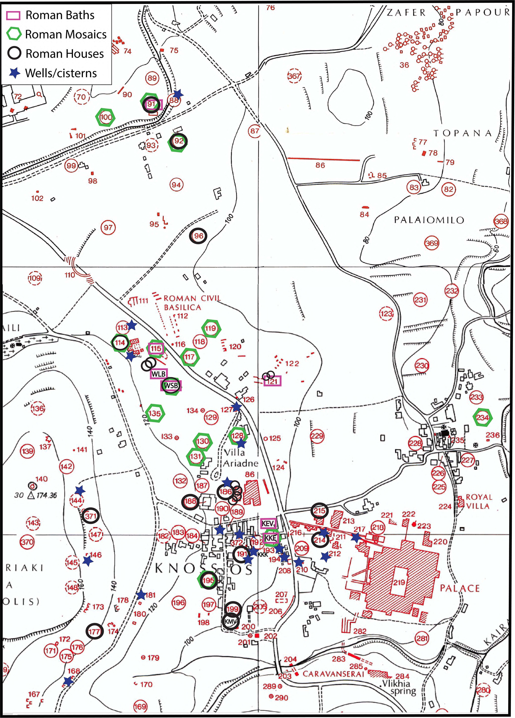
Fig. 24. Distributions of reported Roman houses, baths, mosaics, wells and cisterns within the marked area.
Table 2. Roman architectural remains identified within the footprint of the modern Knossos village.

An aqueduct branch supplying the North House
A Roman aqueduct branch supplied the North House quarter 110 m due north of the cistern in Knossos village (Bougada Metochi) (Figs 23 and 24, KS 186). The North House was a substantial Roman residence above the north end of the so-called Unexplored Mansion (Flouda Reference Flouda2017, 353, fig. 6, n. 29). A portion of the house (20 m by 20 m) was first excavated during the Second World War (Flouda Reference Flouda2017, 353), with the site of the Unexplored Mansion being excavated further in the late 1960s and 1970s, when the post-Minoan material fell under the charge of Hugh Sackett (Sackett et al. Reference Sackett, Branigan, Callaghan, Catling, Catling, Coldstream, Higgins, Popham, Price, Price and Waywell1992, vii). Sackett and his team excavated portions of five relatively well-appointed houses and a paved street in this area (Sackett et al. Reference Sackett, Branigan, Callaghan, Catling, Catling, Coldstream, Higgins, Popham, Price, Price and Waywell1992).
Today, a 12.5 m-long section of the aqueduct's wall still stands to a height 1.5 m high (rising to 105.1 m amsl at its western end) at the northern end of the excavated area. The remaining exposed channel is just under 30 cm in width, with only one remaining capstone in situ at its western extent.Footnote 30 For Sackett's excavation team, the aqueduct wall provided ‘a convenient northern limit to the excavations’ (Sackett et al. Reference Sackett, Branigan, Callaghan, Catling, Catling, Coldstream, Higgins, Popham, Price, Price and Waywell1992, vii and 18). In 1992, Sackett described the aqueduct wall as follows:
The walling [of the aqueduct] stood up to 1.50 m high at its south face, which also formed the outside wall of the North House, and had a total width of 2.50 m. The masonry was well constructed and used mortar between stones. The water culvert itself was 35 cms wide and had a considerable down gradient at this point running from west to east (0.50 in 10 m, or 1 in 20). Sherds from cleaning operations can be dated as late as the 4th century A.D. and indicate that the channel remained open even after the destruction of all the buildings in the excavated area. The strength of the structure, the care with which it was lined, covered and kept up, as well as the long continuity of its use, seem to support an interpretation as aqueduct rather than drain. (Sackett et al. Reference Sackett, Branigan, Callaghan, Catling, Catling, Coldstream, Higgins, Popham, Price, Price and Waywell1992, 57–8; also see pl. 38c)
The wall elevation is composed of regularly shaped blocks set in neat rows with occasional small chinking stones to maintain linearity (see Popham and Sackett Reference Popham and Sackett1972–3, 50, fig. 2). The flow along the branch runs west–east with a drop of 0.4 m along its length, similar to the gradient noted by Sackett above. It is likely that this aqueduct branch tapped the civic water supply running on a south–north axis in the area of the Stratigraphical Museum. Sackett also came to this conclusion, noting that ‘it is also pertinent that much later water channels have also brought water to Knossos from this direction along the contour at the foot of the Acropolis’ eastern slope. Further excavation to the west should pick it up in that direction’ (Sackett et al. Reference Sackett, Branigan, Callaghan, Catling, Catling, Coldstream, Higgins, Popham, Price, Price and Waywell1992, vii and 18).
While no private baths were reported from any of the partially excavated Roman houses in the area of the Unexplored Mansion, structural bathhouse materials, including clay spacer pins manufactured in local clay, were discovered in late second-century AD secondary deposits and in wash covering the excavation (Sackett et al. Reference Sackett, Branigan, Callaghan, Catling, Catling, Coldstream, Higgins, Popham, Price, Price and Waywell1992, 246, no. R3, 3a, pl. 217, and for U165, see 250–6). Their presence in a late second-century AD deposit (n. R3, 3a) points to an earlier bathhouse in this area.Footnote 31 In the nearby Stratigraphic Museum excavations, a series of architectural elements including pilae and terracotta pipes were thought to be ‘reused from some adjacent, out of use or destroyed hypocaust and thus bath’ (Warren Reference Warren1987–8, 93, figs 27–8). The presence of an aqueduct branch in this residential area might indicate that either a public bathhouse lay somewhere in the vicinity or that the houses themselves were fitted with private bathing installations. Private bath suites were regular installations in elite Roman housing, and were even found in homes of the aspiring elite. A degree of relative wealth is on display in the interior decor of the Roman houses in the area of the Unexplored Mansion (Sackett et al. Reference Sackett, Branigan, Callaghan, Catling, Catling, Coldstream, Higgins, Popham, Price, Price and Waywell1992, 53). Walls in the House of the Diamond Frescoes were lined with plaster imitating marble from Thessaly and Numidia (Sackett et al. Reference Sackett, Branigan, Callaghan, Catling, Catling, Coldstream, Higgins, Popham, Price, Price and Waywell1992, 37–47; Paton Reference Paton, Cadogan, Hatzaki and Vasilakis2004b, 453–5), and the North House contained possible mosaic bedding layers (Sackett et al. Reference Sackett, Branigan, Callaghan, Catling, Catling, Coldstream, Higgins, Popham, Price, Price and Waywell1992, 49), while fragments of painted plaster and marble dado were found in collapse from a second storey, all of which point to reasonably prosperous residences (Sackett et al. Reference Sackett, Branigan, Callaghan, Catling, Catling, Coldstream, Higgins, Popham, Price, Price and Waywell1992, 53), which might extend to private bathing fixtures.Footnote 32 Wardle classified a bathing facility in trench C of the K2K excavation at Knossos as the private bath suite of a larger unexcavated house complex (Wardle's Small Bath: WSB in Table 3, Figs 23 and 24; Wardle Reference Wardle2000; Forster Reference Forster2009, 46; Kelly Reference Kelly, Gardner, Herring and Lomas2013, 138; Sweetman Reference Sweetman2013, 174), while the same private classification was applied to other Roman bathing blocks on Crete, notably those at Myrtos, Minoa and Pachyammos (Kelly Reference Kelly, Gardner, Herring and Lomas2013, 143–55; Reference Kellyforthcoming). Private bathing facilities have been identified in several more extensively excavated Roman house complexes on Crete, including the villa at Makryialos (Kelly Reference Kelly, Gardner, Herring and Lomas2013, 145), the House of Pheidias at Kissamos (Markoulaki Reference Markoulaki, Loukos, Xifaras and Pateraki2009, 364–5) and House 2 at Eleutherna Sector I (Themelis Reference Themelis1994–6, 269, 268 for plan, pl. 11; Reference Themelis2002, 80).
Table 3. Reports of Roman baths at Knossos.

The aqueduct skirting the western edge of the Villa Dionysos field
Despite a general lack of field evidence for the historic aqueducts along the roadway between the Caronissi Bridge and the village in 2019, an aqueduct is labelled further along this route in a series of twentieth-century plans, where it follows the road running above the village and skirting the western edge of the Villa Dionysos field, eventually turning north-east to link up with the main road to Iraklio. Slabs were visible on the surface of the track before the road was paved in the 1990s (Todd Whitelaw pers. comm.).
In Fyfe's map of Knossos, two architectural features along this trajectory are labelled ‘Water Supply from Aqueduct’: one at the crossroads above the village and another opposite the main entrance to the Venizelion Hospital.Footnote 33 The route is finally relabelled ‘Venetian Aqueduct and Path’ by 1928.Footnote 34 In 2021, a 115 m-long tract of later aqueduct walling was plotted opposite the entrance of the Venizelion hospital (Kelly Reference Kelly2022, fig. 2). Smyth also reported a channel in a trench in this location, and the top of this channel was 1 m below ground surface.Footnote 35 While the country road skirting the west side of the Villa Dionysos field may follow the Venetian and Ottoman-Egyptian lines, the Roman aqueduct may have run east of the road following the c. 115 m contour. In this position, it would have run lower than the road elevation but still above Wardle's baths (WSB and WLB in Table 3; marked on Fig. 24).
Urban development below the line of the Roman aqueduct
Private Roman houses have been recorded below the aqueduct line, with a distribution extending from the footprint of the upper Knossos village (KS 191, 195, 199, also KMV; Table 2), immediately north over the Unexplored Mansion (KS 186, including the five houses partially excavated by Sackett et al. Reference Sackett, Branigan, Callaghan, Catling, Catling, Coldstream, Higgins, Popham, Price, Price and Waywell1992), in the surrounds of the Stratigraphical Museum (KS 188; Warren Reference Warren1987–8), in the Villa Dionysos field (KS 114; Halbherr's excavations are summarised by Morgan Reference Morgan2009, 47–52; and WSB, with two further townhouses reported between them by Wardle Reference Wardle2000, Trench E) (Fig. 24).
Immediately east of the main road, Hogarth (Reference Hogarth1899–1900a, 81, nos 14–16, pl. 12) recorded houses and a larger public building (KS 121), which was subsequently labelled either a temple or a bath (Table 3). In Reference Hood and Smyth1981, the discovery of a villa (KS 96) and an inscription of VESPASI north-east of the so-called Civil Basilica (KS 112) prompted Hood and Smyth to describe the area as ‘an important residential quarter in the 1st and 2nd centuries A.D.’. That this area was a Roman focal point was first recognised by Halbherr, during his 1885 excavation (see Morgan Reference Morgan2009, esp. 55) and supported by Hutchinson's rescue excavations of the mid-1930s, when statuary and mosaics were discovered east of the main road (see for example Hutchinson Reference Hutchinson1938–40, 23; Sweetman Reference Sweetman2003, 534, no. 17, pl. 87a–c). Closer to the Venizelion Hospital, two Roman structures with mosaic flooring were reported as houses in the Knossos Survey (KS 91–2), although KS 92 was also tentatively mooted as a possible public building; these seem to mark the northern extent of this recorded residential spread.Footnote 36
Similar high densities of Roman urban residential housing have been recorded in other Cretan centres, not least Kissamos, where, thanks largely to the work of Stavroula Markoulaki, over 30 townhouses have been identified (and five baths), with mosaics recorded from 15 different plots (Markoulaki Reference Markoulaki, Loukos, Xifaras and Pateraki2009; Sweetman Reference Sweetman2013, 99). Roman construction at Knossos, however, has since been shown to be much more extensive than that envisaged by the 1981 Knossos Survey (and even the entire corpus of excavated Roman architectural materials in the valley) by the wide distribution of mosaic tesserae and imported marble veneer fragments recovered from across the entire northern sector of the city by the Knossos Urban Landscape Project (KULP) (Whitelaw, Bredaki and Vasilakis Reference Whitelaw, Bredaki, Vasilakis, Mitsotaki, Tzedaki-Apostolaki and Giannadaki2019a, 10–11, fig. 6).
The 1981 Knossos Survey demonstrated that, in the area just below the aqueduct trajectory, the distribution of private Roman properties (as outlined above) is interspersed with mosaic pavements (KS 91–2, 100, 114–15, 117, 119, 128, 130–1, 135, 195 and KKE), ‘Roman buildings’ (KS 105, 111, 113, 185, 189), ‘Roman concrete’ (KS 76, 84, 86, 90, 94–5, 98, 101–2, 111, 120, 122, 124, 135, 198), Roman statuary (KS 76, 93, 97 [colossal], 99, 104, 109, 113–14, 129, 132, 136 [colossal]), including at least two statues of Hadrian KS 97 and 114 and possibly Sabina KS 99 (Kotsonas Reference Kotsonas2016, 304–5, fig. 3; Karanastasi Reference Karanastasi, Frances and Kouremenos2016, 108, fig. 8:9; Baldwin Bowsky Reference Baldwin Bowsky2017, 441–2), Roman inscriptions (KS 58, 59, 76, 93, 96, 99, 136, 168), numerous Roman wells (e.g. KS 88, 113–14, 127–8, 186, 193–4, 212, 372, but also throughout the cityscape), Roman tanks (notably KS 190–1, 210) and Roman roads (KS 116, 208, 211). This record is reinforced and supplemented by Roman materials found in the frequent small-scale rescue excavations conducted in trenches across the area, reviewed by Sweetman and Grigoropoulos (Reference Sweetman and Grigoropoulos2010, 344–5, table 1). When these findspots are pinned against the backdrop of Roman tesserae plotted by KULP, we see a much more expansive density across the north of the site (Whitelaw, Bredaki and Vasilakis Reference Whitelaw, Bredaki, Vasilakis, Mitsotaki, Tzedaki-Apostolaki and Giannadaki2019a, 10–11, fig. 6).
The Roman residential architectural spread plotted by the 1981 Knossos Survey, extending from the upper Knossos village towards the Villa Dionysos, and further north, rests below the 115 m amsl contour on the eastern slopes of the Acropolis Hill (the Monastiriaki Kephala Hill), with relatively little clearly identified residential housing extending above this horizon.Footnote 37 While spreads of Roman material extend all the way to the summit, as confirmed by KULP (as cited in Morgan Reference Morgan2009, 54, fig. 6), the nature of this material has yet to be defined in terms of residential or public, Roman or Byzantine.
A large-scale geophysical survey conducted in 2015–18 detected terracing in the areas of Monastiriako Kephali and south of the Villa Ariadne (Christakis Reference Christakis, Stampolides, Papadopoulou, Laurentzatou and Phappas2019, 229; Bennet Reference Bennet2017, 23–4). Sackett's team also observed a similar effect in the layout of the Roman houses in the footprint of the Unexplored Mansion, which were terraced into the hillside and often laid out over different levels.Footnote 38 To a more gradual extent, the Villa Dionysos and Wardle's baths are laid out over terraces set into the hillside. In light of this evidence, we might imagine a series of wealthy terraced residences and complexes laid out over the hillside, descending from the 115 m contour towards the main Knossos–Iraklio road, the Leoforos Knossou.
As noted above, the area around the so-called Civil Basilica (KS 112; see Fig. 24) has long been identified as an affluent civic focus (Cadogan Reference Cadogan, Myers, Myers and Cadogan1992, 134; Paton Reference Paton, Cadogan, Hatzaki and Vasilakis2004b, 453–5; Sweetman and Grigoropoulos Reference Sweetman and Grigoropoulos2010, 349–50; Paton Reference Paton2022, 1). Sweetman and Grigoropoulos (Reference Sweetman and Grigoropoulos2010, 350) report on ‘buildings of an increasingly monumentalized nature the nearer they were to the Civil Basilica’ along a line of DEYAH trenches leading from the Venizelion hospital. In addition, they list a series of public imperial buildings in the zone around the so-called Civil Basilica, including the theatre (KS 110), a monumental structure with an apse (KS 111) and potentially public and private baths (Sweetman and Grigoropoulos Reference Sweetman and Grigoropoulos2010, 349).
Urban development immediately below the 115 m amsl contour on the lower slopes of the Acropolis Hill may have been influenced by access to the civic water supply. In Roman Chersonisos, the operation (and most likely the construction) of the city's six public baths (and potentially numerous private facilities) was facilitated by the installation of a public aqueduct (Galanaki et al. Reference Galanaki, Grigoropoulos, Kastanakis, Mandalaki, Papadaki, Triantafyllidi, Angelakis and Koutsoyiannis2006, 269; Papadaki, Triantafyllidi and Grigoropoulos Reference Papadaki, Triantafyllidi and Grigoropoulos2010). Over 100 m south of the Villa Dionysos, a small bathing complex was classified by the excavator, Kenneth Wardle, as the private bath suite of a wealthy townhouse (WSB in Table 3; Kelly Reference Kelly, Gardner, Herring and Lomas2013, 138; Sweetman Reference Sweetman2013, 174; Forster Reference Forster2009, 46; Figs 23–4). This bathing block is located at a level of c. 105 m amsl (floor level of room 1), c. 40 m east of the country road skirting the 115 m amsl contour (Tomlinson Reference Tomlinson1995–6, 40–1, fig. 23; Sweetman and Grigoropoulos Reference Sweetman and Grigoropoulos2010, 340, fig. 1; Christakis Reference Christakis, Stampolides, Papadopoulou, Laurentzatou and Phappas2019, 209). The excavated portion of the bathing block measured 250 m2 (Forster Reference Forster2009, 46–8). It is relevant that the room set at the highest point in the complex and closest to the country road was a cistern (room 1). This cistern sat adjacent to the largest room of the exposed complex, fitted with a net pattern floor mosaic (room 3), while a sunken plunge pool was also identified, along with two hypocaustal areas and another mosaiced floor.
Immediately south-east of the Villa Dionysos, Wardle partially unearthed a 6 m-high wall associated with a fragment of mosaic and marble veneering, which he interpreted as part of a potentially massive bathhouse (WLB on Table 3 and Fig. 24). The wall was traced for 30 m, suggesting a complex occupying an estimated area of 900 m2, which Wardle (Reference Wardle2000; Reference Wardle1998, 47) suggested had two or possibly three storeys. The wave-crest motif running flush with the wall measured 0.25–0.30 m in width and constitutes the largest example of this border motif on the island (Sweetman Reference Sweetman2013, 173, no. 10), indicating a room of considerable size. While the identification of this structure as a bath is not certain, it would be fitting that a large public bathhouse would be sited in such a well-positioned public quarter laid out just below the civic aqueduct of Knossos.
In the map of Knossos published in 1928 (and originally marked on Fyfe's 1900 map), a semi-circular mosaic found directly across the main road from the so-called Civil Basilica was labelled by Evans ‘Roman mosaic perhaps baths’ (Evans Reference Evans1928, opposite 547). Hood and Smyth considered this semi-circular mosaic and ‘a stretch of concrete wall running parallel with the road immediately south of no. 114 [the Villa Dionysos]’ as part of the same complex (Table 3:KS 115; Sweetman Reference Sweetman2013, 177–8, no. 16). The wall to which they refer is likely to be that of WLB, which sits in this exact location; however, that Wardle's wall (with its wave-crest mosaic) is part of the same complex as the semi-circular mosaic is unconfirmed.
At least in the second century, water from the public supply may have been conducted to a robust cistern, W27, in the south-west corner of the Villa Dionysos (Paton Reference Paton2022, 28–9, fig. 17). Paton (Reference Paton2022, 34–5) suggests that this supply may have serviced a private bath suite within the villa, along its southern extent, part of which may still be in place. Another shallow brick-built tank, lined with opus signinum, was located immediately south-west of the villa (Paton Reference Paton2022, 35–6, fig. 21). A pipe (14 cm diameter) conducted water to the tank (exposed for 0.75 m by 0.80 m) from further west (Kelly Reference Kelly, Gardner, Herring and Lomas2013, 148; Paton Reference Paton, Di Vita, LivaDioti and Simiakaki2004a, 285). The villa's placement, the level of its central courtyard at roughly 100 m amsl, the substantial cistern to the south-west of the oikos, and the elevated tank located to the south-west of the site, would all suggest connection to the public supply (Paton Reference Paton, Di Vita, LivaDioti and Simiakaki2004a, 282). The water feature in the courtyard and the lead pipes enclosed in stone-built channels below the surface of the peristyle point to a sophisticated water network within the house (Paton Reference Paton2022, 11). The presence of wells in the villa, notably Well A, present a supplementary supply with limited, or even specific, application; Paton (Reference Paton2022, 10) attributes Well A to watering the courtyard garden. That well water would have to be manually hauled up points to the presence of servants within the household.
The degree of comfort enjoyed in private Roman homes connected to the civic aqueduct supply is demonstrated at Kissamos, in western Crete, where the two-storeyed House of Pheidias is fitted with six mosaic floors and its own private bathing suite (Markoulaki Reference Markoulaki, Loukos, Xifaras and Pateraki2009, 364–5; Reference Markoulaki2000; Andreadaki-Vlazaki Reference Andreadaki-Vlazaki2002, 270; Sweetman Reference Sweetman2013, 268, no. 207). The Villa Dionysos (KS 114), with its peristyle design, mosaic flooring, and notable statuary is clearly a house of some standing.Footnote 39 That this villa, decorated with some of the finest mosaics seen on Crete (Sweetman Reference Sweetman2007, 68, 73), would have been fitted with a private bath suite, as yet unidentified, is in keeping with the trappings of houses of this calibre both on Crete and across the empire. A quantity of spacer pins reported by Paton (Reference Paton, Cavanagh and Curtis1998, 127; Reference Paton2022, 14, 25, 35) in deposits overlying the Villa Dionysos need not have been transferred from another facility and may have originated from an installation within the wider private complex.
Water pipes lining the Roman road above the Royal Road
But water distribution and access was not limited to this urban quarter, and water was conducted downhill in both pipes and open channels in the direction of the Palace. A Roman cistern was discovered by Hutchinson, east of the village, in the modern carpark of the Palace (cited in KS 210; Christakis Reference Christakis, Stampolides, Papadopoulou, Laurentzatou and Phappas2019, 212), while directly opposite the modern entrance to the Palace, Hutchinson also reported a possible Roman road (KS 208).Footnote 40
Evans also unearthed, 118 metres along the Royal Road, a section of Roman road running on the same axis 2 m above the Minoan road level, an overlay which Evans (Reference Evans1903–4, 50, 52, figs 17–18) viewed as a ‘historic coincidence’. He followed this stretch of Roman roadway for 9.2 m and temporarily preserved it for 8.5 m (Evans Reference Evans1903–4, 50 and 52). Evans (Reference Evans1903–4, 52) noted that
on the South side of the roadway run three conduits or water-pipes. Two of these, formed of a kind of cement mixed with potsherds, are square in section and laid on a mortar bedding. The other is round, and consists of sections of terra-cotta piping fitted into one another, and with their necks pointing East, showing that the flow of water was in this direction.
In 2000, two parallel lines of opus signinum still adhered to a surviving upper section of the wall flanking the Royal Road (Kelly Reference Kelly2004, vol. 2, 34, no. 8.10, vol. 3, pl. 19a).
The Roman cistern north of the Theatral Area of the Palace
Evans returned to the area almost 30 years after first noting a ‘Roman conduit’ leading to the west side of the Theatral Area in the Minoan Palace (Evans Reference Evans1935a, 49; KS 217). Over 200 m east of the upper village of Knossos (Bougada Metochi), a sizeable cistern is positioned to the north of the Theatral Area in the Minoan Palace where it sits at an altitude of 93 m amsl (KS 217) (Fig. 25). These remains are all that is left of the Roman cistern dynamited by Evans (1902–3, 106) at the turn of the century. While Evans was aware of the Roman water distribution system in the Palace surrounds, he did not always appreciate this later material trace, and he complained that this Roman cistern extending over the Theatral Area could only be removed ‘by a long process of blasting’ (Evans Reference Evans1902–3, 106; Reference Evans1935a, 18). Evans (Reference Evans1902–3, 106) described ‘a huge flooring of Roman cement … 65 centimetres in thickness and intruding on the area to be excavated to the extent of some 60 square metres’.Footnote 41

Fig. 25. Roman cistern to north of Theatral Area of Palace, photographer facing east.
The thick layer of opus signinum coating the cistern (Fig. 25) is comparable to opus signinum linings recorded along the length of the Roman aqueduct and its related cisterns. But why was this cistern positioned here and what civic quarter did it serve? In practical terms, this large cistern could serve any Roman structures nearby founded below its elevation of 93 m amsl, but recorded urban infrastructure in the immediate area is lacking. While Roman houses were reported immediately to its west (KS 214 and 215),Footnote 42 the nearest documented Roman levels are in the House of the Frescoes area (Whitelaw pers. comm.). Although at the considerable distance of 300 m to the north-east, a Roman structure fitted with a mosaic did overlook the river from its elevation of 70 m amsl (KS 234 and 236). This structure would have had a particularly attractive terraced aspect, located just below Makryteikhos village overlooking the Katsambas River with a view of the slopes of Ailias on the far side of the wide valley (the same view enjoyed by residents of the Royal Villa over a millennium earlier).
DISCUSSION
How much water was being delivered to Roman Knossos and what implications did this have for the city's urban footprint? In 1892, Fundana's rate of flow was listed at 200 massoures (approximately 1296m3/day; see Kelly Reference Kelly2022, 124, table 1 for calculations), twice that of any other spring in the district. The rate of flow reported in 1892 (TAH Z8 no. 4356), while presenting a static historic figure, is comparable to one of the three main sources for the Gortyna aqueduct in the Zaros-Gergeri region, that at Sternes, which Giorgi (Reference Giorgi2016, 25, 30) reported produced anywhere from 1200–3600m3/day, depending on the season. Giorgi (Reference Giorgi2016, 30, 60 n. 169) envisaged a combined flow rate of 8400–14,400m3/day for all the springs which potentially supplied the aqueduct of Gortyna (a figure she compared to that of Carthage at 17,000m3/day). At Gortyna, the lower estimates for the population range between 17,000 and 34,000 (Giorgi Reference Giorgi2016, 60). Giorgi (Reference Giorgi2016, 60, n. 175) estimated that the total amount of water available per capita per day in Roman Gortyna was 280 litres for the lower population range.Footnote 43
Both pre-industrial and modern data show that 20 litres of water is the minimum daily quantity needed per capita per day to meet basic drinking and minimum hygiene needs.Footnote 44 It is important to note, however, that basic drinking needs were already met in the pre-Roman phases of evolving cities, and by inference, Roman aqueducts were usually designed to meet a need beyond these basic expectations. Giorgi presents a huge volume of water being delivered to Gortyna by aqueduct, and she reasonably questioned why so much water (effectively all the water from the southern Ida catchment basin) was conducted to the Roman city (Giorgi Reference Giorgi2016, 60–6, n. 169). She identified (1) the baths, (2) private elites and the upwardly mobile, and (3) irrigation in the Mesara as the biggest consumers of this excess. In the Roman period, baths were probably the greatest consumers of water within the urban footprint (Hodge Reference Hodge1992; Fabre et al. Reference Fabre, Fiches, Leveau and Paillet1992; Fabre, Fiches and Paillet Reference Fabre, Fiches and Paillet2000), as were mosques and their associated baths under Ottoman and Ottoman-Egyptian rule, but the aqueduct could also simultaneously feed multiple drinking fountains – for the full array of amenities supplied by aqueduct in a nineteenth-century Ottoman city, see Ertürk, Şeker and Öztürk (Reference Ertürk, Şeker and Öztürk2013) on Safranbolu in Turkey.
According to findings from KULP, Whitelaw and Trainor have estimated that by the Middle Roman period, the population of Knossos shrank to 7000–10,000 people, presenting a potentially considerable drop from the 10,000–17/18,000 individuals calculated for the Classical and Early Hellenistic periods.Footnote 45 Based on these population estimates, the civic aqueduct of Roman Knossos was delivering a minimum daily water supply per capita of 130 litres at the peak of its population.Footnote 46 Any excess water could have fed any potential bathhouses identified within the city's footprint (see Table 3), while the existence of further installations is clear from structural bathhouse materials (including pilae, spacer pins and terracotta pipes) reported from the excavations of the Unexplored Mansion (Sackett et al. Reference Sackett, Branigan, Callaghan, Catling, Catling, Coldstream, Higgins, Popham, Price, Price and Waywell1992, 246, no. R3, 3a, pl. 217; Kelly Reference Kelly, Gardner, Herring and Lomas2013, 136), the Stratigraphic Museum (Warren Reference Warren1987–8, 93, figs 27–8) and the Villa Dionysos (Paton Reference Paton, Cavanagh and Curtis1998, 127; Reference Paton2022, 14, 25, 35).
Public aqueducts facilitated an unprecedented ease of access to drinking water, served as an urban cooling system,Footnote 47 enhanced the urban aesthetic and guaranteed mountain purity within the heart of the city (Rogers Reference Rogers, Aristodemou and Tassios2018, 175, Argos, 176–7, Corinth; Leigh Reference Leigh, Aristodemou and Tassios2018, 229–31, Athenian Agora). While altitude was often a key determinant when choosing a spring to tap for aqueduct construction, abundance and perceived purity of upland spring water also constituted important considerations.Footnote 48 Aqueducts did not displace all other forms of water collection and access, local springs were still tapped and wells and rainwater collection systems still operated within the city, but connection to the civic supply afforded a level of comfort and undoubtedly a measure of prestige.
Beyond Crete, we know that the benefits were not exclusively enjoyed by city-dwellers. Bannon highlights that while the Roman state controlled these natural sources, it could also grant access and withdrawal rights to private individuals residing within both the city and its surrounding countryside.Footnote 49 Statius in Silvae 1.3 celebrates the supply of the villa of Manilius Vopiscus at Tivoli, detailing its conduction in lead pipes from the Aqua Marcia across the Aniene River (Silvae 1.3.66–9; Putnam Reference Putnam2019, 86–7; Thomas and Wilson Reference Thomas and Wilson1994, 146–7).
As noted, Giorgi considered the irrigation of the Mesara as a possible application for the residual water delivered to Gortyna. It is at least possible that at Knossos run off from the aqueduct supply was deployed for the irrigation of crops and orchards cultivated in the city's hinterlands west of the Katsambas (although we must also allow for the large cemeteries in the city's immediate surrounds). At Knossos, Sweetman and Grigoropoulos (Reference Sweetman and Grigoropoulos2010, 340) observed, mainly on the positioning of mortuary remains in the site's wider surrounds, ‘that the city occupied in some form the extent of the valley floor, some 2500 m north to south and 1500 m east to west; that is to say an area 25 times greater than that which has been explored in detail’ and that a significant portion of this area would have comprised agricultural land. Data from KULP suggest that the urban area shrank from 120 ha to 90 ha from the Hellenistic to the Early Roman period, and even further as the Roman period progressed (Whitelaw, Bredaki and Vasilakis Reference Whitelaw, Bredaki and Vasilakis2017, 12; Reference Whitelaw, Bredaki, Vasilakis, Mitsotaki, Tzedaki-Apostolaki and Giannadaki2019a, 10–11, fig. 6; Trainor Reference Trainor, Mitsotaki, Tzedaki-Apostolaki and Giannadaki2019, 4–5; Christakis Reference Christakis, Stampolides, Papadopoulou, Laurentzatou and Phappas2019, 201 n. 25).
Our 2019 field inspection plotted a length of 12.42 km for the Roman aqueduct of Knossos. The physical length of a water supply was correlated with quantities of raw materials and the time and manpower needed to complete its construction, factors which fed directly into costs (Leveau Reference Leveau, Blackman and Hodge2001, 85). The length of the Roman aqueduct supplying Knossos lies at the shorter end of the civic scale, but the construction of its 1 km-long Roman aqueduct tunnel would, nonetheless, have constituted a major consideration for the aqueduct's cost of construction. As already noted, the tunnel was over twice the length of the notorious tunnel along the Saldae aqueduct (see Table 1). Chanson and Leveau each estimated that the construction of Roman civic aqueducts could amount to a gigantic undertaking often involving army personnel (both for labour and engineering expertise) with costs of 1–3 million sesterces per kilometre.Footnote 50
Hero cautioned against excessive expenses incurred from needlessly lengthy trajectories in his Dioptra 6 (Lewis Reference Lewis2001, 265). Our 2019 fieldwork suggests that careful planning underpinned the trajectory of the Roman aqueduct supplying Knossos. Ancient sources refer to topographic surveys conducted prior to the construction of aqueducts to identify sources and plot the most cost-efficient functional trajectories in the field.Footnote 51 We know that the route of the Venetian aqueduct of Candia (Iraklio) was surveyed intensively prior to any ground being broken (Kelly Reference Kelly2022, 122–3; Gerola Reference Gerola1932–40, 14–16; Moresini, Relazione n. 12, in Spanakis Reference Spanakis1950, 28).
In Hero of Alexandria's first-century AD work on the dioptra, one of the mathematical agents used is a surveyor who is laying out a watercourse and has to gauge the height difference between two points (Dioptra 6.1–21; Roby Reference Roby and Sialaros2018, 73–4; Lewis Reference Lewis2001, 263–5). The second-century AD inscription found in Lambaesis, mentioned above (CIL VIII 2728), informs us that the military engineer, Nonius Datus, surveyed the route of the Saldae aqueduct, stating:
Therefore I, who had first made the survey, had decided on the route of the aqueduct, had arranged for it to be done according to the plan which I had given the procurator Petronius Celer, completed the work. (translation Cuomo Reference Cuomo2011, 145)
Having the army on hand was particularly advantageous for large-scale construction projects of any period: its presence afforded expertise, an organised skilled workforce and access to specific tools and materials.Footnote 52 At Autun, in Gaul, the orator Eumenes gave thanks to the emperor for deploying the army to repair the aqueduct:
to work for our profit in the goodwill of a guest's gratitude and make waters that had ceased to flow, and new rivers as well, pour forth upon the withered vitals, as it were, of the exhausted city. (Eumenius, Oratio pro instaurandis scholis, oratio 4, translation Nixon and Saylor Rodgers Reference Nixon and Saylor Rodgers1994, 155–6; also cited in Leveau Reference Leveau, Blackman and Hodge2001, 89)
The completion of any given construction project might not go as planned, and even with military input, the tunnelling project along the Saldae aqueduct stalled (mentioned above); the aqueduct was only inaugurated in the early 150s, over 13 years after the route was first planned in AD 137, following a series of delays and mishaps, perhaps aggravated by the long absences of the original surveyor who had since retired (Cuomo Reference Cuomo2011, 147; CIL VIII 2728). Philostratus in his Life of Herodes Atticus tells us that he secured three million drachmae (or 12 million sesterces) from Hadrian to build an aqueduct for Alexandria Troas (Lives of the Sophists 2.1.2), but as costs spiralled to seven million drachmae, his father stepped in to make up the shortfall (of 16 million sesterces) for the completed project (Leveau Reference Leveau, Blackman and Hodge2001, 90). Pliny (Letters 10.37) relays disastrous costs at Nicomedia, where 3,329,000 sesterces was spent on an unfinished aqueduct project, with a further two million raised in taxes squandered on a second abandoned project. Finally, Pliny (Letters 10.37), on locating a potential spring, asks Trajan for a skilled engineer or architect to be sent out to oversee the aqueduct project, to prevent a repetition of two previously disastrous attempts.
While it is hazardous comparing costs from one period to another, we do know exactly how much was, at least, budgeted for the construction of the nineteenth-century aqueduct supplying Iraklio: Bowring's report of March 1838 specifies that Mehmet Ali allotted 5000 Ottoman lira (henceforth l) to the construction of the aqueduct.Footnote 53 This amount is reiterated by both Raulin and Rashed, who put the cost of the restoration project at 500,000 piastres (125,000 francs) or 500,000 grosia or kuruş, respectively (Raulin Reference Raulin1867, 58 and 144; Rashed Reference Rashed1978, 113; Strataridaki, Chalkiadakis and Gigourtakis Reference Strataridaki, Chalkiadakis and Gigourtakis2009, 4 n. 30). To put the expense into some form of perspective, in 1838 ‘The receipts on the island did not exceed on an average 400,000 dollars, or 80,000l, of which one-fourth was paid to Mustapha Pacha’ (Bowring Reference Bowring1840, 154). Clearly, in 1838, 500,000 grosia (or 5000l) was a substantial amount of money, but, even so (and allowing for budget overruns), the return on the nineteenth-century aqueduct construction project must have far exceeded (or at least was expected to exceed) its cost over time. Moreover, the discovery of the Roman tunnel in the nineteenth century would have significantly lowered costs, and the project is repeatedly referred to as repair and reconstruction work, presumably of the older aqueduct. Knowledge of the existence of the Roman tunnel dispensed with a laborious boring scheme, while the extended Roman aqueduct served as a blueprint for the later trajectory, the construction of which was largely a matter of consolidating the Roman remains.Footnote 54 Spanakis reported that the Egyptian army were deployed to clean out the Roman tunnel at Skalani in 1838/9 (Spanakis Reference Spanakis1981, 92; Reference Spanakis1990, 48; see also Strataridaki, Chalkiadakis and Gigourtakis Reference Strataridaki, Chalkiadakis and Gigourtakis2009, 4; Chalkiadakis Reference Chalkiadakis2012, 460). Spyropoulos notes that by the eighteenth century in Iraklio (Kandiye), the military were not only responsible for, but highly invested in, the functioning of the water supply; the 1719 records for the city demonstrate that military and administrative elites constituted the majority of private individuals who had access to running water (Spyropoulos Reference Spyropoulos2018, 105, 107, citing Stavrinidis Reference Stavrinidis1984, 48–51; TAH 15 nos 266–8).
The extent of the Roman aqueduct's route from Fundana demonstrates that the authorities at Knossos felt at liberty to construct an aqueduct through swathes of land to the south, but what underpinned this license to exploit such a relatively far-flung spring in the Roman period, and for that matter, what authoritative action sealed legitimate ownership of any spring in the Roman period? A measure for securing claim to spring water in the private sphere is outlined in an inscription from Viterbo, in Lazio, central Italy, where owning the land in which the spring rises and through which any associated infrastructure passes underpinned rights to that supply (CIL II 3003; Bannon Reference Bannon2009, 73, 136; Reference Bannon2017, 62 and 65–7). The inscription records that Mummius Niger Valerius Vegetus, the proprietor of the Villa Calvisiana, bought the land surrounding a spring and a 9 km corridor of land, cutting through nine estates, with the eminent owners all listed in the inscription, to facilitate the construction of an aqueduct to water his estate (Marzano Reference Marzano2007, 170, n. 64; Campbell Reference Campbell2012, 96).
If land ownership was a prerequisite for the control of a spring, then we might comfortably assume that the territory of Roman Knossos extended sufficiently far south to lay claim to this relatively remote resource. Unfortunately, no dedicatory inscription for the Roman aqueduct survives. That Knossian territory extended well into the lower reaches of the Juktas foothills is implied, however, through both the text and findspot of an inscription discovered in 1969, at Karnari, a village located 10 km to the south of Knossos (Ducrey Reference Ducrey1969, 846, no. 3). The text outlines a dispute of AD 84 concerning a citizen of the Knossian colony, Plotius Plebeius, and some Capuan land-holdings (praefectura Campana), which bordered lands owned by the complainant (Iraklio Museum AE 1969/70, 0635; España-Chamorro Reference España-Chamorro2021; Paton Reference Paton, Cadogan, Hatzaki and Vasilakis2004b, 451–2; Rigsby Reference Rigsby1976, 319; Ducrey Reference Ducrey1969; Elliott Reference Elliott2004). The original findspot of the boundary marker at Karnari is relevant as it marks an extensive territorial spread encompassing the Juktas foothills and their numerous water sources (España-Chamorro Reference España-Chamorro2021, 391).
Beyond land ownership, Bannon noted that under Roman law ‘any work or construction around the water supply could be interpreted as an expression of the owner's right to the water’ (Bannon Reference Bannon2017, 66). In this regard, Spyropoulos’ (Reference Spyropoulos2018, 110) conclusion for his study of eighteenth-century Iraklio has resounding relevance for diachronic aqueduct studies:
Their origins notwithstanding, the tactic used by all these elites was similar: They claimed the water of all the springs discovered in the vicinities of their cities by creating infrastructure connecting the former to the latter. After ensuring the appropriation of a large amount of water resources for their own establishments, they provided the rest of the water for public use – mainly through private endowments – thus presenting themselves as benefactors in the eyes of the local populace.
In this light, the Roman aqueduct supplying Knossos served as an architectural measure of territorial reach, a physical form of referencing that could be harnessed to serve the Ottoman-Egyptian regime many centuries later.Footnote 55 We see that, ultimately, aqueducts were not just physical constructions independent of the social and institutional frameworks of the period in which they were constructed and functioned, but rather were intricately connected to the varied lifestyles of the communities that they served.
ACKNOWLEDGEMENTS
Firstly, we must thank the staff of the Ephorate of Antiquities of Heraklion for allowing us to walk the aqueduct route in the first place and for their many kindnesses while in Crete. We give particular thanks to director, Vasiliki Sithiakaki, and both Eliza Kavoulaki and Eleni Kanaki, who helped us so much while we were in Crete. We are also indebted to Eleni Tsiknakou and Christina Papoulia at the Irish Institute of Hellenic Studies at Athens for their unfailing support and administrative assistance. We thank Kostis Christakis, Knossos Curator, for his care and hospitality while we resided at the Knossos Research Centre in 2019. We owe a debt of gratitude to Todd Whitelaw for editing this work so meticulously and for taking us to task over several points. We must extend this thanks to Peter Liddel for his endless patience and diligence with the many rewrites (and for humouring a wordy acknowledgement section). Hubert Chanson was also kind enough to read and discuss the work at length at an early stage. Similarly, Eustathios Chiotis was very generous with his expertise on water tunnels. Enoch Cheng and Nadia Coustinas have also kindly assisted at the initial and final stages of this publication. We also warmly thank the Istituto Veneto di Scienze, Lettere ed Arti, for permission to publish beautiful images from their collection (Fondo Giuseppe Gerola, Copyright Istituto Veneto di Scienze, Lettere ed Arti, all rights reserved). While out in the field in 2019, we were welcomed and assisted by many locals, including Artemis Kokkinou, her father, Manolis Kokkinos, and Manolis Vasilakis, who all shared their archaeological knowledge with us and provided us with a range of Cretan seasonal harvest fruits (including almonds, walnuts and pomegranates, and some Cretan aloe vera). On subsequent field checks (in 2022) Amanda Kelly was greatly assisted by Mara Panagiotaki, Stelios Manolioudis, Manolis Afrathianakis, Zacharias Aletras and Anna Moles. While walking the aqueduct route, we have experienced truly Homeric philoxenia from the numerous locals (harvesters, hunters and homeowners alike) that we met along the way. As always, we are deeply indebted to The Gerda Henkel Foundation as none of this would be possible without their funding.


 Open access