


Introduction
In Mongolia, cities have been an integral part of nomadic society for more than a millennium. Abandoned urban sites from various periods dot the land, inscribing memories of lost empires and alliances into the cultural landscape. The relationship between sedentary urban and mobile herder lifeways has constituted a key cultural, economic and political factor in one of Eurasia's major pastoralist formations (Bruun & Narangoa Reference Bruun and Narangoa2006). This history is most prominently present in the Orkhon Valley, which preserves traces of various urban centres that include Karakorum, the capital of the Mongol Empire in the thirteenth and fourteenth centuries AD (Rogers et al. Reference Rogers, Erdenebat and Gallon2005). Much less is known about the period of the Qing Dynasty (1636–1911), when Mongolia had fallen under Manchu dominance. This is the era in which most modern Mongolian cities are rooted, but subsequent political developments led to the abandonment or destruction of many of these urban sites.
Project background
A collaborative project between the Mongolian Academy of Sciences and Kiel and Dresden Universities, Abandoned Cities in the Steppe: Roles and Perception of Early Modern Religious and Military Centres in Nomadic Mongolia, is studying these abandoned urban sites. We combine archaeological, geographical, historical and ethnographic approaches to identify facets of urban life in early modern Mongolia, and to examine how their physical and mental traces continue to impact the modern landscape and shape cultural memory (Ressel et al. Reference Ressel2020; Ethier et al. Reference Ethier and Zimmermannin press). Contrasting military sites with Buddhist religious centres, the project focuses on three case studies: (i) the monastic site of Baruun Khüree in the southern Orkhon Valley; (ii) pit-structure settlements as potential military sites in the adjacent Khangai Mountains; and (iii) the ruins of the Manchu military city of Uliastai in western Mongolia. Here, we present the first results of analyses of the so-called Grubenanlagen (pit structures)—unusual, large settlement forms with structured layouts that have so far received little scholarly attention.
A new site type in the Khangai Mountains
The Orkhon Valley in central Mongolia, under UNESCO World Heritage protection since 2004, is a nucleus of archaeological research from the Palaeolithic to the modern era. A survey programme undertaken between 2008 and 2011 identified a new site type, comprising 14 settlement structures hidden in valleys in the nearby Khangai Mountains (Bemmann et al. Reference Bemmann2010; Ahrens Reference Ahrens2020) (Figure 1). These sites measure up to several hundred metres across and consist of numerous regularly arranged large pits and/or stone and earthen platforms. Based on diagnostic materials from surface collections (e.g. ceramics, coins), the Grubenanlagen were preliminarily dated to the Qing Dynasty. High-resolution aerial photography and digital elevation models (DEM) created by our team in 2018 enabled an initial assessment of the layout and structural remains of the sites. In a first archaeological-ethnographic field campaign in summer 2019, we investigated a group of two unenclosed Grubenanlagen sites (GA-09 and GA-10) and one walled enclosure (WA-01), thereby conducting the first ever comprehensive study of this settlement type (Figure 2).
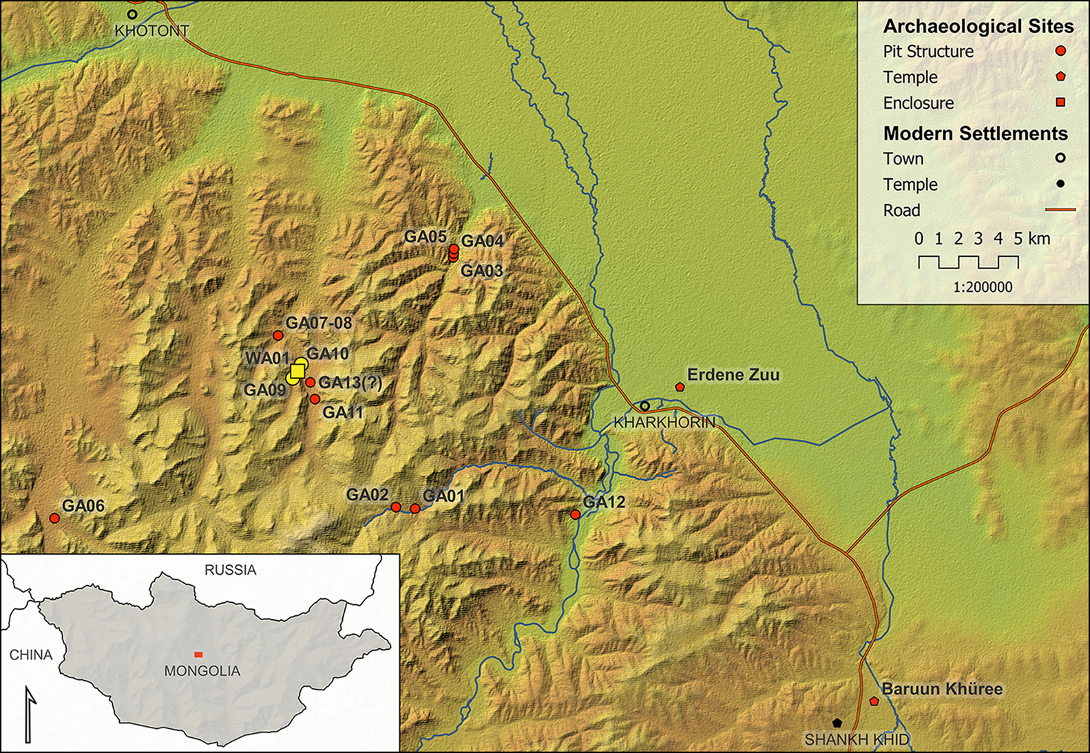
Figure 1. Grubenanlagen (pit structure) sites in the Khangai Mountains (investigated complex highlighted in yellow) and further locations mentioned in the text (map by H. Whitefield, ZBSA Schleswig).

Figure 2. Digital elevation model (DEM) combined with photographic imagery of walled enclosure WA-1 and Grubenanlage GA-10, and 2019 excavation trenches (white rectangles) (image by M. Oczipka, HTW Dresden).
We excavated two test trenches, each measuring 1.5 × 4m, at WA-01 and GA-10 (Figure 2). WA-01 is an impressive landmark, with its well-preserved enclosing bank (Figure 3) and row of rectangular structures along the wall, interpreted as houses or tents. GA-10 comprises rows of pit dwellings, visible as small depressions forming a rectangular area. Both structures intersect at one corner, indicating a chronological sequence. In WA-01, no clear evidence of architectural remains was found in the test trench and only animal bone and a few artefacts were uncovered (Figures 4 & 6, no. 4).
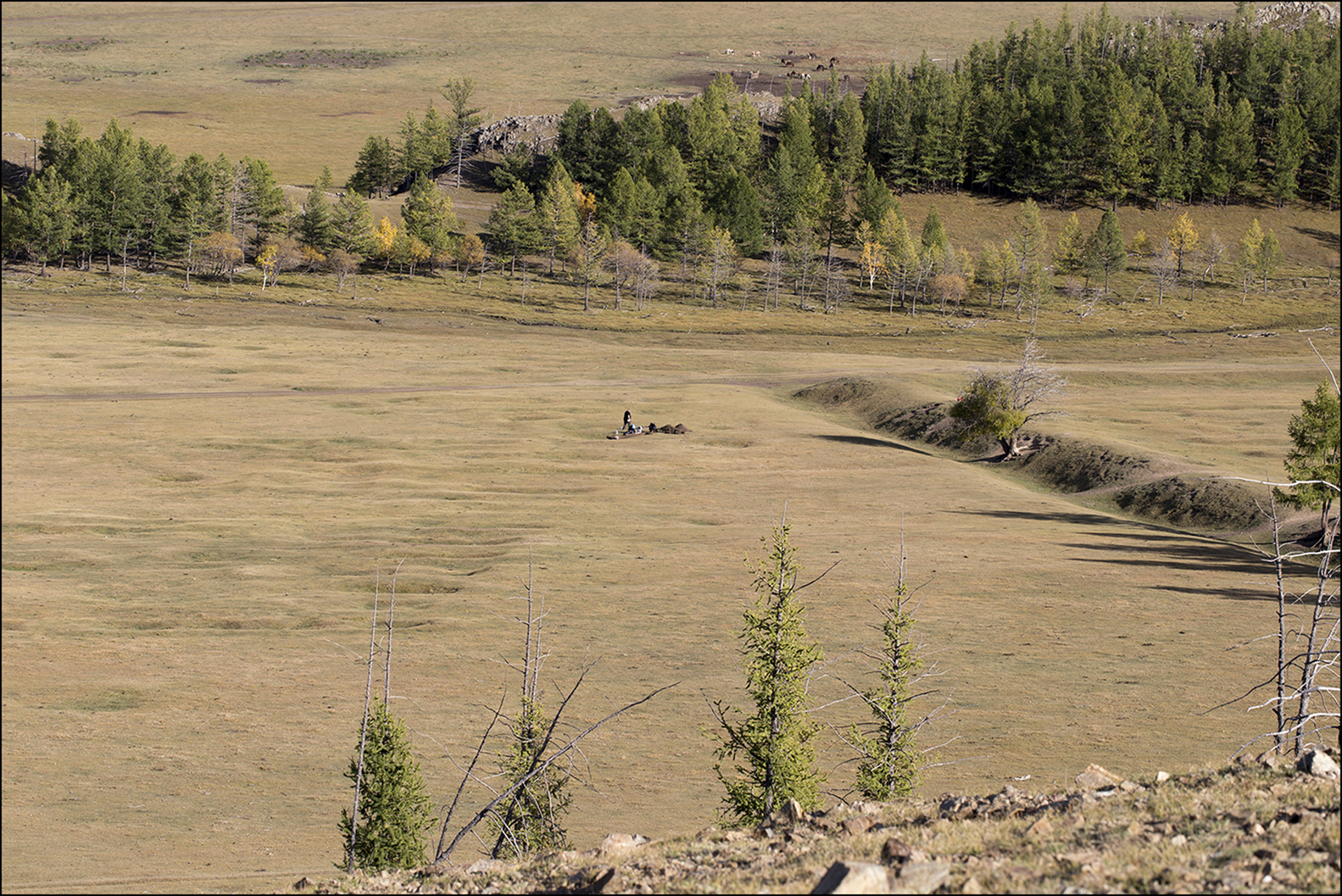
Figure 3. Intersecting corners of WA-1 and GA-10, and 2019 excavation trench at GA-10 (photograph by S. Jagiolla, CAU Kiel).

Figure 4. Kiel University students excavating the test trench at walled enclosure WA-1 (photograph by S. Jagiolla, CAU Kiel).
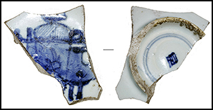
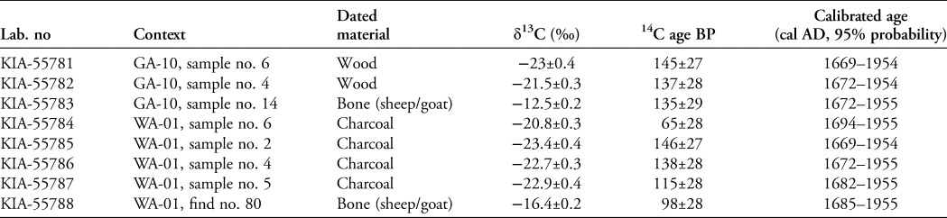
Excavation in GA-10 revealed a wall made of loam and horizontal timbers, which attests to the presence of a rectangular building measuring approximately 5 × 6m, with a sunken floor and a central pillar (Figure 5). Finds include blue and white porcelain, a bronze coat button and animal bones (Figure 6, nos 2–3). An iron arrowhead (Figure 6, no. 1) was found embedded in the outer face of the building wall, suggesting on-site combat. A series of eight radiocarbon dates—the first absolute dates for this site type—confirm an early modern to modern age for both investigated structures, with a peak in probability in the late seventeenth to eighteenth centuries AD (Table 1).
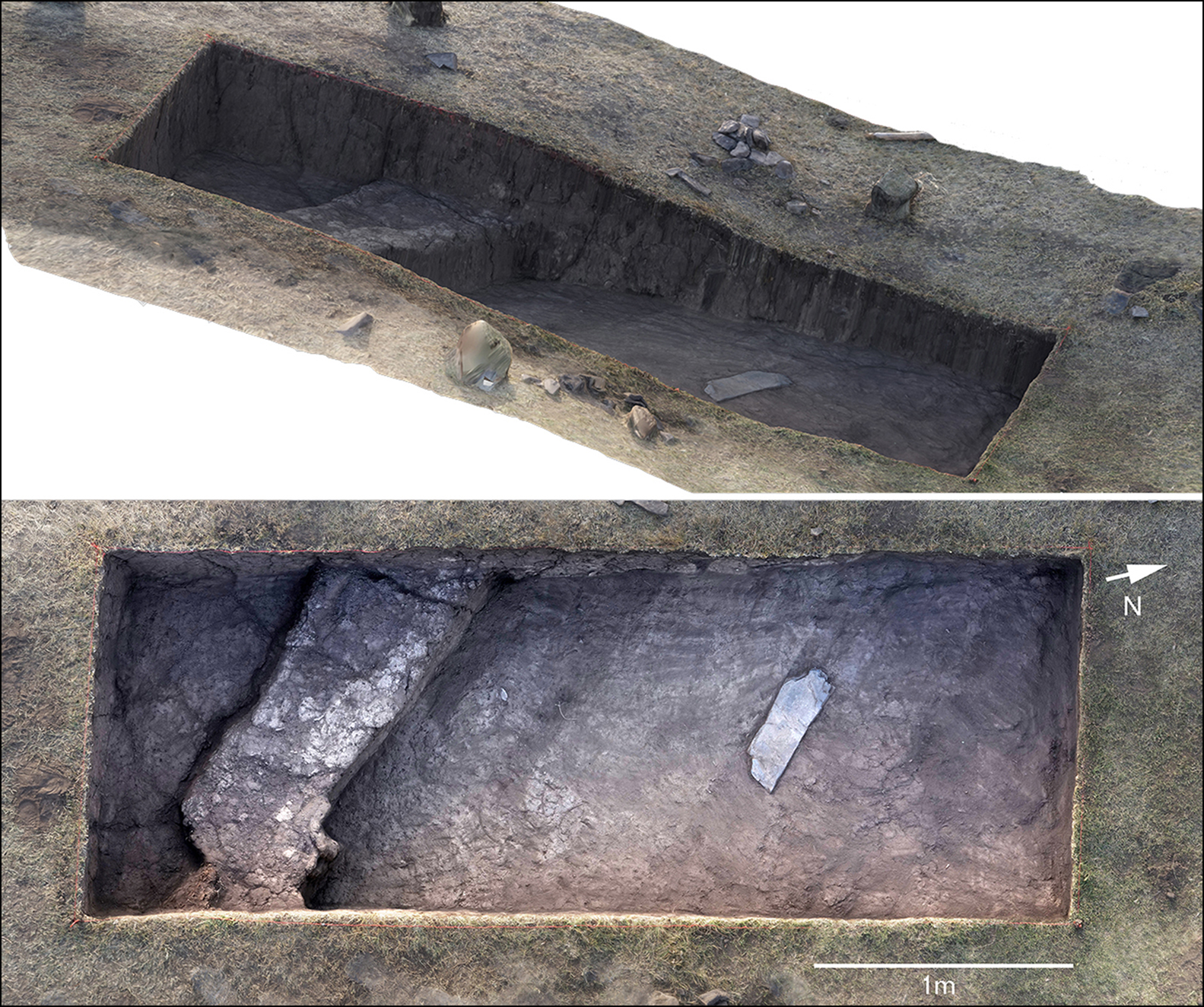
Figure 5. Two views of the 3D model of the test trench at pit structure GA-10, showing the remains of a rectangular building (figure by M. Oczipka, HTW Dresden).
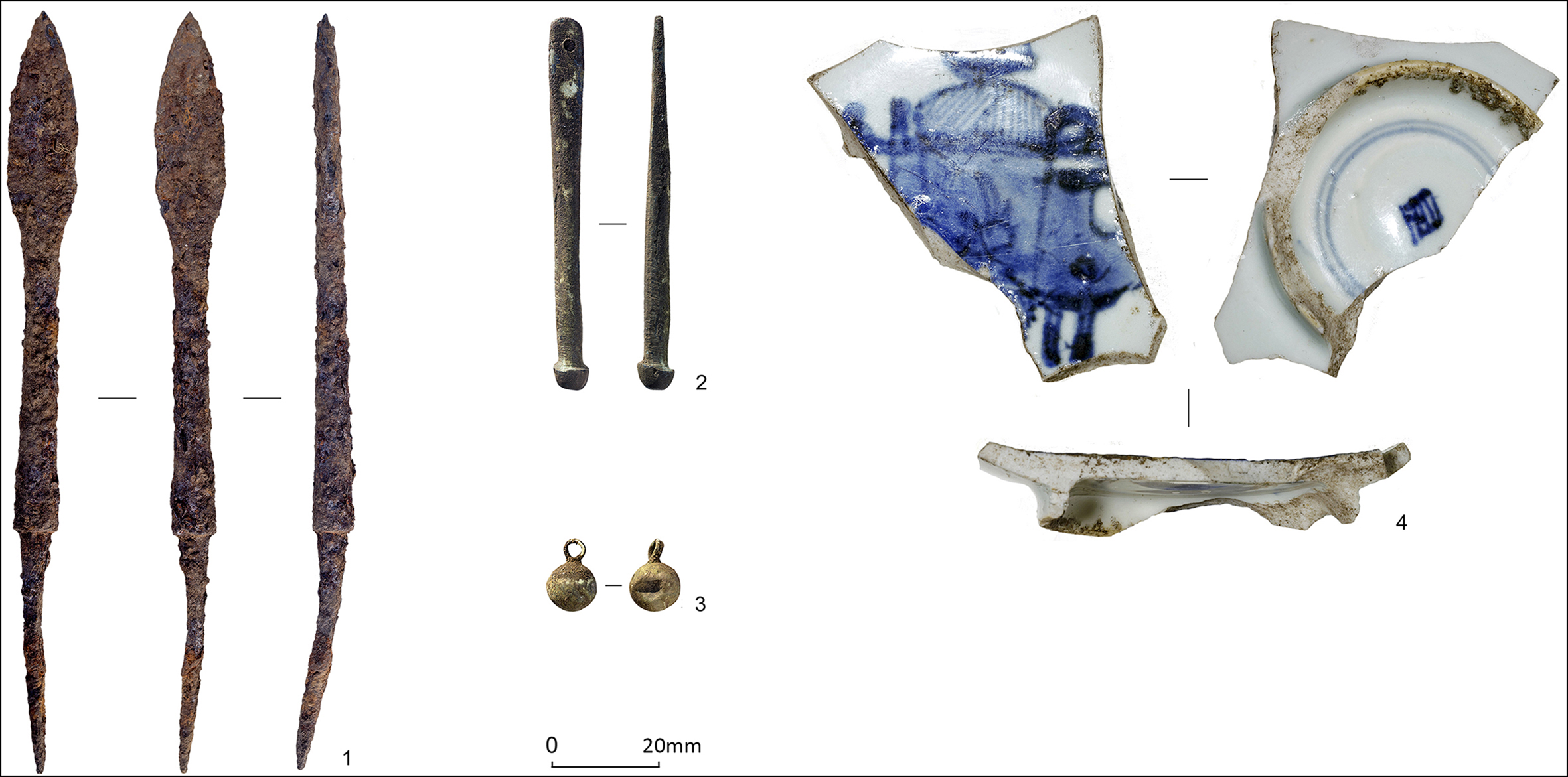
Figure 6. Materials found in the trenches at GA-10 (1–3) and WA-1 (4): 1) iron missile head; 2) bronze pendant; 3) metal button; 4) porcelain bowl fragments (photographs by S. Jagiolla & J. Ethier, CAU Kiel).
Table 1. Radiocarbon dates from WA-01 and GA-10, Khangai Mountains, central Mongolia. The results were calibrated using OxCal v4.4.2 (Bronk Ramsey Reference Bronk Ramsey2020) and the Post-bomb atmospheric NH1 curve (Hua et al. Reference Hua, Barbetti and Rakowski2013; Reimer et al. Reference Reimer2020).
Marching camps or garrisons?
Our investigations at the Grubenanlagen have confirmed their Qing period age. Surviving house structures with earth-timber walls question earlier interpretations of the Grubenanlagen as short-lived, seasonal marching stations—assumptions that were based on contemporaneous seventeenth to eighteenth century depictions of Manchu camps showing light tents of the troops (Ahrens Reference Ahrens2020: 168). Our new findings show that at least some of the sites must now be regarded as more permanent settlements or garrisons, most likely connected to the increased military presence in the region. The role of enclosures, such as WA-1, as possible central sites requires further assessment. Chinese or Manchu military personnel, likely in conjunction with Inner Mongolian and local participation, were probably stationed in the Orkhon Valley region as part of the territorial expansion measures under Emperor Kangxi in the eighteenth century (Sanjdorj Reference Sanjdorj1980). Intra-Mongolian conflicts also repeatedly led to armed encounters, possibly involving the stationing or movement of military units. The variance in layout and size of these sites may therefore be related to both chronological factors and to different military actors in this buffer zone between Russia and China (Bawden Reference Bawden1968).
Future directions
Future interdisciplinary research, building upon our archaeological pilot work at the Qing-era pit structure sites in central Mongolia, is planned. This will involve geomagnetic survey to trace building structures and activity areas, and small-scale excavations at fortification lines, such as the WA-1 enclosure, to clarify their temporal association. New fieldwork in spring 2022 at Baruun Khüree monastery, approximately 30km south-east of WA-1 and GA-10, has revealed evidence pertaining to the second focus of the project: the contemporary Buddhist religious sites that now await integrated assessment.
Acknowledgements
We thank our 2019 team for their enthusiastic work and reliable help, specifically Bastian Breitenfeld, Clara Drummer, Christina Franken, Miroslav Holinka, Ariunchimeg Khasbagana, Gongorjav Narangerel, Tanja Schreiber, Sebastian Schultrich and Batchuluun Tsedendorj.
Funding statement
The project Abandoned Cities in the Steppe: Roles and Perception of Early Modern Religious and Military Centres in Nomadic Mongolia is funded by the Lost Cities programme of the Gerda Henkel Foundation (AZ 01/LC/19). It is an associated project within the Cluster of Excellence ROOTS funded by the German Research Foundation under Germany's Excellence Strategy (EXC 2150–390870439).


 Open access