


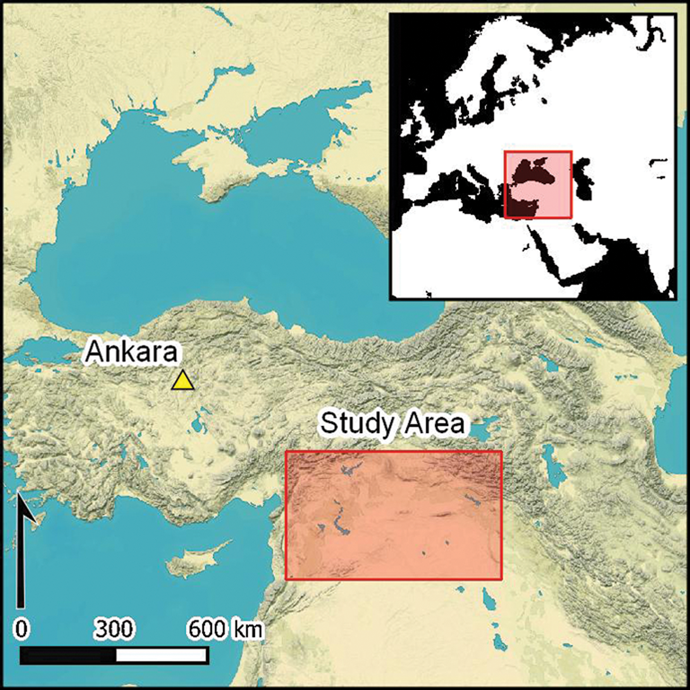
Introduction
In the 1920s, at the beginning of the ‘age of aviation’, the Jesuit French priest Father Antoine Poidebard undertook one of the world's first aerial archaeological surveys, using a biplane and a camera to document hundreds of ancient forts and other sites throughout what today is Syria, Iraq and Jordan (Poidebard Reference Poidebard1934). Having piloted a biplane during the First World War, Poidebard later became a priest at Université Saint-Joseph in Beirut and joined the 39th Aviation Regiment of the French Levant forces, through which he began his expansive aerial survey of desert regions. Although today Poidebard is remembered primarily for his technological innovation in using aerial photography as an archaeological survey tool (Griswold Reference Griswold2019), an achievement that also fascinated his contemporaries (e.g. Dussaud Reference Dussaud1934; Jones Reference Jones1934; Hopkins Reference Hopkins1935), the substance of his investigation was based on mapping Roman-period forts and defensive installations along the eastern periphery of the empire. In his magisterial monograph, La Trace de Rome dans le desert de Syrie (Reference Poidebard1934), Poidebard presents hundreds of previously unknown forts and other sites over an area that stretches more than 1000km along the Roman frontier or limes (Figure 1).
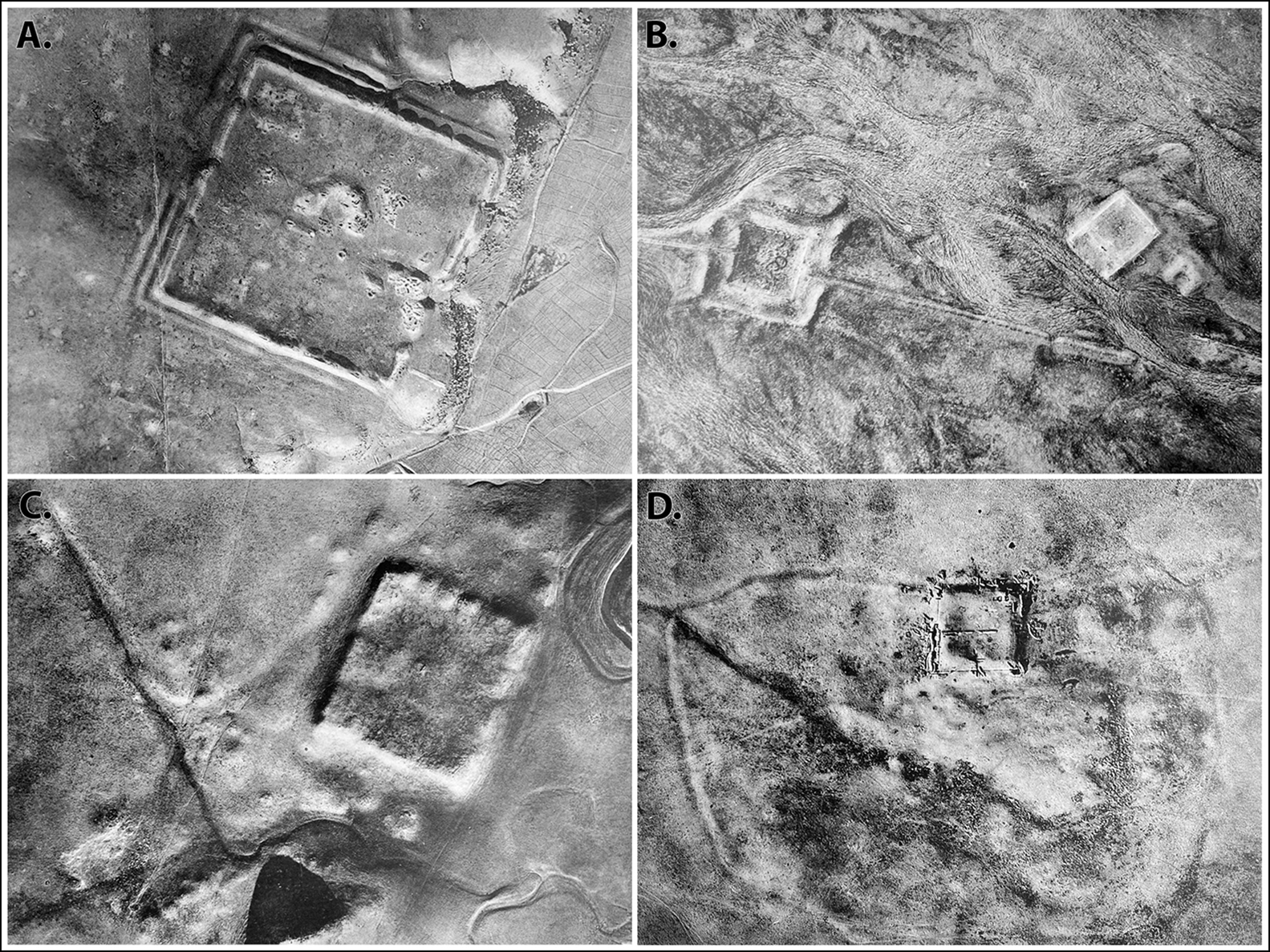
Figure 1. A sample of Poidebard's (Reference Poidebard1934) aerial photographs: A) fort at Qreiye; B) Roman fort and medieval caravanserai at Birke; C) fort at Tell Zenbil; and D) castellum at Tell Brak.
Since the 1930s, historians and archaeologists have debated the strategic or political purpose of this system of fortifications (e.g. Graf Reference Graf1978; Liebeschuetz Reference Liebeschuetz and de Blois2007; de Jong & Palermo Reference De Jong, Palermo, Düring and Stek2018), but few scholars have questioned Poidebard's basic observation that there was a line of forts defining the eastern Roman frontier. This article presents the results of a regional-scale remote sensing-based survey utilising declassified CORONA and HEXAGON spy satellite imagery from the 1960s and 1970s (Casana Reference Casana2020a & Reference Casana, Lawrence, Altaweel and Philipb), which demonstrate there are far more forts than previously recognised, extending over a much larger region. As part of a systematic programme to map archaeological sites and features across a study area in the northern Fertile Crescent, stretching from western Syria to north-western Iraq, we found 396 previously undocumented forts or fort-like buildings, compared with the 116 forts recorded by Poidebard (Reference Poidebard1934) in the same area. Significantly, the spatial distribution of the forts we have mapped no longer supports Poidebard's central thesis that they constituted a broadly north-south line along the eastern boundary of the empire. Instead, we show that the forts form a roughly east-west line following the margins of the inland desert, connecting Mosul on the Tigris River in the east with Aleppo in western Syria. While many questions remain, our results fundamentally challenge understandings of the number, distribution and function of these distinctive elements of the ancient Near Eastern landscape.
Background
In his aerial survey, Poidebard (Reference Poidebard1934) set out to search for evidence of Roman-period fortifications along the eastern frontier of the empire. He focused on a route stretching from Borsa on the Jordanian border, north through Palmyra and Raqqa, south-east along the Euphrates River to its confluence with the Khabur, then north again to Nisibis on the modern-day Turkish border, ending at the Tigris River (Figure 2). During the reigns of Septimius Severus (AD 145–211) and Diocletian (AD 284–305), the Roman Empire made massive investments in military and transport infrastructure along its eastern border (Oates Reference Oates1968), and Poidebard's survey followed a road built under Diocletian, the strata Diocletiana. Poidebard recorded hundreds of fortified military buildings, including some of the best-known Roman forts in the region (Figure 3). He photographed all of these forts from the air and investigated many on the ground as well, conducting soundings at several of them and larger-scale excavations at the castellum at Tell Brak, Syria (Figure 4). Based on this evidence, Poidebard (Reference Poidebard1934) argued that the forts were mostly constructed during the second and third centuries AD, essentially functioning as a wall to fortify the eastern Roman provinces against incursions by Arab nomads or Persian armies.

Figure 2. Poidebard's (Reference Poidebard1934) map of the Roman limes, including the hypothesised route of principal road (in bold) that Poidebard followed on his aerial survey.
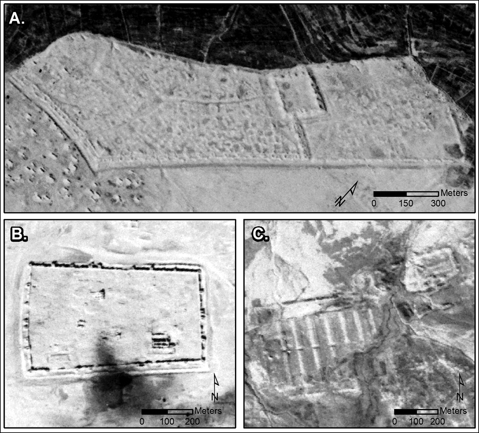
Figure 3. CORONA images showing major sites: A) Sura (NASA1401); B) Resafa (NASA1398); and C) Ain Sinu (CRN999) (figure by authors; CORONA imagery courtesy US Geological Survey).
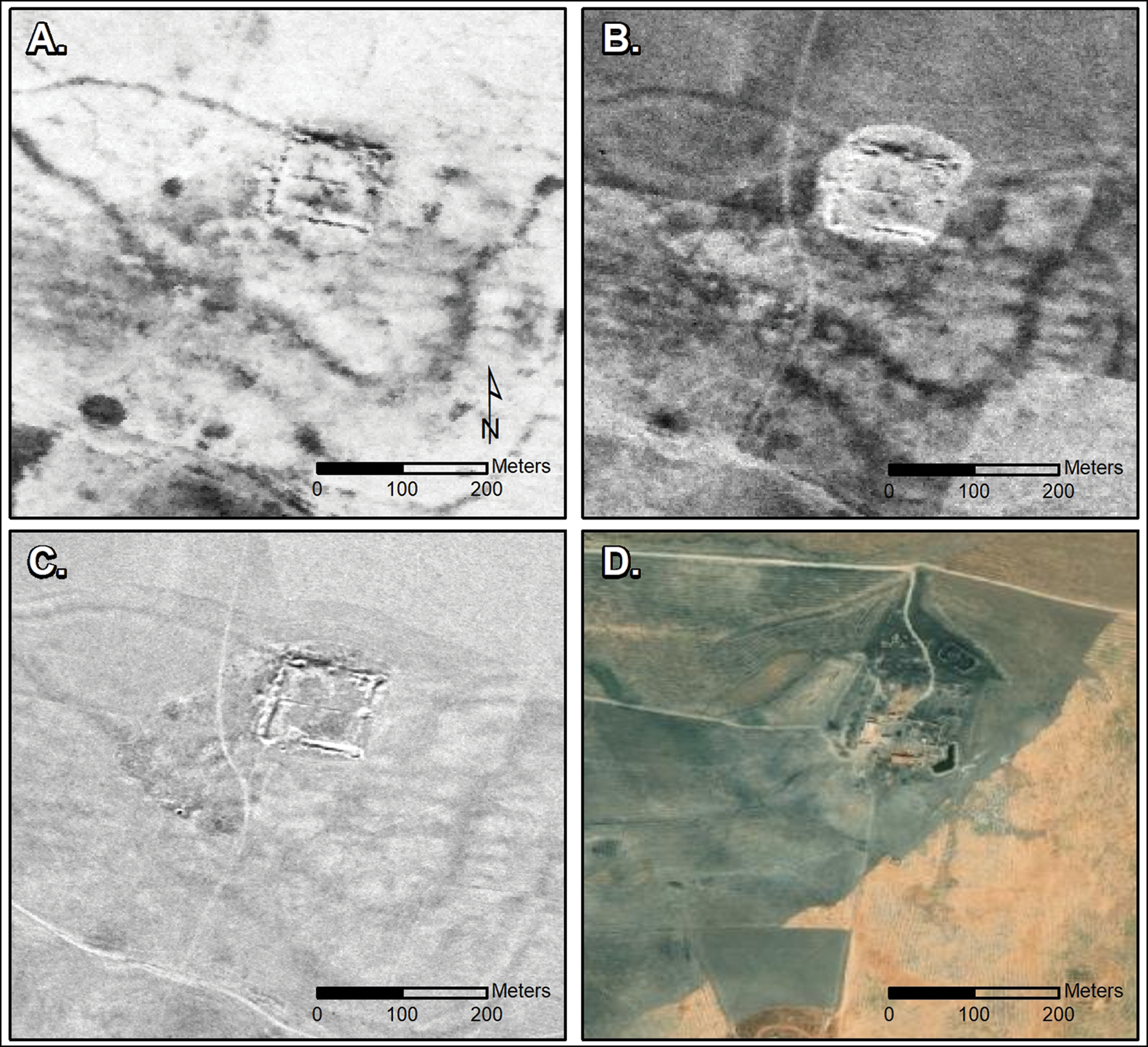
Figure 4. Castellum at Tell Brak: A) CORONA (1102, 17 December 1967); B) CORONA (1105, 4 November 1968); C) HEXAGON (1204, 17 November 1974); and D) modern satellite imagery (© ESRI and Maxar Technologies) (figure by authors; CORONA and HEXAGON imagery courtesy US Geological Survey).
Poidebard was praised by his contemporaries for his technical achievement and his wide-ranging discoveries (Dussaud Reference Dussaud1934; Jones Reference Jones1934; Hopkins Reference Hopkins1935), and his findings helped inspire a long history of scholarship that explored dimensions of Roman military, economic and political policies along its eastern periphery (e.g. Isaac Reference Isaac1990; Kennedy & Braund Reference Kennedy and Braund1996; Fisher Reference Fisher2011; de Jong & Palermo Reference De Jong, Palermo, Düring and Stek2018). Nonetheless, many scholars have argued that the forts could not have functioned as a wall because they were located too far apart from one another to prevent passage into the province. Instead, it has been argued the forts typically guarded strategic oases, presumably to provide protection for the movement of military and commercial caravans (Graf Reference Graf1978; Liebeschuetz Reference Liebeschuetz and de Blois2007: 421–38). Others have argued that the forts functioned primarily to defend sedentary populations against raids by nomadic groups, who commonly moved throughout the region (Mayerson Reference Mayerson1986; Parker Reference Parker1987), perhaps specifically to guard against the perennial threat of captive-taking and slave-raiding (Lenski Reference Lenski2011: 256–60). These issues may have been particularly acute as increasing numbers of formerly nomadic peoples began to settle in Roman territory after the third century AD (Mango Reference Mango, Borrut, Debié and Sodini2011), at the same time that more policing operations were delegated to local allied tribal groups (Liebeschuetz Reference Liebeschuetz2015).
Despite long-standing interest among historians, there has been only limited archaeological research on the fortifications of the eastern Roman limes. David and Joan Oates (Reference Oates and Oates1959) excavated the large fortress at Ain Sinu, located just east of the Jebel Sinjar in northern Iraq, uncovering a second- to fourth-century castellum and barracks (Figure 3C). A German project in the 1990s focused on the area between Palmyra and Raqqa, excavating at the major fortress of Sura on the Euphrates (Figure 3A), the castella of Tetrapyrgium and Resafa (Figure 3B) and the small fort of Cholle (Konrad Reference Konrad2001; Figure 5A). A survey project in the Jebel Bishri region, south of the Euphrates, likewise investigated several Roman and late Roman forts and discovered a previously undocumented military encampment (Lönnqvist et al. Reference Lönnqvist, Aro-Valjus and Lönnqvist2011). To the south, in modern-day Jordan, the long-running Limes Arabicus project intensively explored Roman fortifications in the area east of the Dead Sea, excavating four sites, including the large legionary fortress at el-Lejjūn, and undertaking a regional survey that located hundreds of other sites, including numerous forts dating from the Iron Age to the medieval period (Clark et al. Reference Clark, Koucky, Parker and Parker2006; Parker Reference Parker2006). But few of the forts identified by Poidebard in eastern Syria and north-western Iraq have been investigated archaeologically, and only a small number of additional forts have been located since his initial publication.
Figure 5. Sample of small forts recorded by Poidebard: A) Cholle (CRN5958); B) CRN2657; C) CRN2545; D) Tell Seyh Hamed (CRN774); E) CRN2857. Newly documented small forts: F) CRN2947; G) CRN2967; H) CRN10098; I) CRN2593; J) CRN10050; K) CRN10092; L) CRN10095 (figure by authors; CORONA imagery courtesy US Geological Survey).
Methods
The analyses described below are based on the results of a long-running project that employs declassified, Cold War-era CORONA and HEXAGON satellite imagery for archaeological investigations. These images formed part of the world's first spy satellite programmes, with CORONA imagery collected from 1960 to 1972 and its successor, HEXAGON imagery, collected from 1970 to 1986 (Casana et al. Reference Casana, Cothren and Kalayci2012; Hammer et al. Reference Hammer, Fitzpatrick and Ur2022). Because these images preserve a high-resolution, stereo perspective on a landscape that has been severely impacted by modern-day land-use changes, including urban expansion, agricultural intensification and reservoir construction, they constitute a unique resource for archaeological research (e.g. Philip et al. Reference Philip, Donoghue, Beck and Galiatsatos2002; Casana et al. Reference Casana, Cothren and Kalayci2012; Ur Reference Ur2013). However, the imagery was captured on elongate black-and-white film using an unusual cross-path panoramic camera system that imparted extreme, non-linear spatial distortions in the imagery, complicating the incorporation of these images in contemporary GIS-based analyses (Casana & Cothren Reference Casana and Cothren2008). Our research as part of the CORONA Atlas Project has developed more efficient and accurate methods for the orthorectification of CORONA imagery, as well as creating an online, open-access distribution platform for corrected data (Casana et al. Reference Casana, Cothren and Kalayci2012; Casana Reference Casana2020a).
Utilising corrected CORONA imagery, we undertook a regional-scale analysis of archaeological landscapes in the northern Fertile Crescent, seeking to document archaeological sites and features across a much larger region than had previously been practical (Casana Reference Casana2020a & Reference Casana, Lawrence, Altaweel and Philipb). Focusing on a 300 000km2 region extending from western Syria to northern Iraq, we first mapped all previously published archaeological sites in this study area, creating a database of approximately 4500 sites. We then began a systematic effort to identify undocumented sites and site-like features, dividing the study area into 5 × 5km survey grids and manually investigating each grid square, ultimately locating more than 10 000 potential new examples. To allow for uncertainty across members of the project team, each new potential site was also given a confidence rating, allowing these observations to be subsequently evaluated by project leaders. Each site was then classified according to morphological criteria, such as shape, the presence of mounding, patterns of erosion and the visibility of architectural features (Casana Reference Casana, Lawrence, Altaweel and Philip2020b). This large dataset has facilitated a range of research initiatives including the mapping of radial route systems (Casana Reference Casana2013), investigations into the sustainability of third-millennium BC settlement (Kalayci Reference Kalayci2016), possible identification of historically known ancient cities (Casana Reference Casana, Ullmann and Weeden2017) and the documentation of war-related looting and site destruction (Casana & Laugier Reference Casana and Laugier2017).
One of the morphological classes in our original analysis was modelled directly on Poidebard's forts, described in our database as a square architectural feature measuring 50–100m per side. In mapping known sites, we attempted to find all the forts originally recorded by Poidebard in our study area; however, this proved to be a difficult task as most forts in his 1934 publication feature only on small-scale maps without any names or designations. Additionally, many sites were damaged by intensified land use in the decades following the 1920s, rendering them less visible or completely absent in the 1960s satellite imagery. Thus, on the CORONA imagery, we were only able confidently to identify extant architectural remains at 38 of Poidebard's 116 forts. Nonetheless, these relocated sites provide a representative sample to demonstrate the expected appearance of such forts, and thus aid significantly in our identification of similar features elsewhere (Figure 5).
We then analysed the results of our larger site prospection effort, identifying all sites and site-like features that had been classified as probable forts. The imagery of each of these potential sites was reinspected to confirm initial assessments by team members and to reduce inter-observer error, ensuring that the identified features were indeed archaeological and that morphological assessments were consistent. Finally, we selected a smaller study area in the Khabur and western Jazireh to conduct a more intensive analysis using multiple forms of imagery, in an effort to locate further potential sites. We selected this intensive study area in part due to the availability of multiple, high-quality CORONA and HEXAGON images covering the region, but also as a result of our observation, during quality assessments, that numerous unrecorded forts were present in this area.
Our initial study (Casana Reference Casana, Lawrence, Altaweel and Philip2020b) relied exclusively on CORONA imagery as the only high-resolution (6 feet/1.83m), declassified imagery available at the time. Our analysts generally utilised a single, high-quality scene to search for potential sites. In our intensive study area, we also took advantage of the 2019 declassification of HEXAGON imagery, a successor programme to CORONA that provides higher resolution data (2 feet/0.61m) collected between 1970 and 1986 (Hammer et al. Reference Hammer, Fitzpatrick and Ur2022). Our intensive study made use of the CORONA 1102 mission (dated 11 December 1967) and 1105 mission (4–5 November 1968), the HEXAGON 1204 mission (17 November 1974), and modern high-resolution colour imagery acquired between 2011 and 2019 (Figure 4). CORONA and HEXAGON imagery were selected for the highest potential site visibility, which in this region is typically in the late autumn or early winter when the fields are clear of most crops and the ground is moistened by winter rains. As is the case with most aerial and satellite imagery, however, localised ground conditions can profoundly impact site visibility in ways that can be hard to predict (Wilson Reference Wilson1982). In our study area, for example, architectural features at fort sites are often clearest on the 1105 mission of the CORONA imagery, despite being of lower spatial resolution than the HEXAGON imagery; although other CORONA and HEXAGON imagery series often reveal other aspects of sites or related features of interest.
Results
Our research successfully identified 396 archaeological features that appear very similar to the forts first documented by Poidebard (Reference Poidebard1934). These probable forts include 290 across the entire 300 000km2 survey region, and 106 probable forts within the smaller, intensive study area of the Syrian western Jazireh (see online supplementary material). Archaeological features that we classified as probable forts are easily distinguished from modern buildings due to the distinctive shadows cast by the latter, compared with the lower, eroded walls that are visible at archaeological sites. The most common form that we interpret as a probable fort is a classic square shape, typically 50–80m per side (Figure 5). These buildings are often isolated, far from other obvious archaeological features, and frequently located in marginal environments with little other evidence of ancient or modern settlement. In his original aerial survey, Poidebard (Reference Poidebard1934) distinguished among large fortresses, modestly sized castella and small towers. The small square features we have documented (Figure 5F–L) closely parallel the size, shape and location of many of the castella or towers documented by Poidebard (Figure 5A–E).
Larger forts recorded by Poidebard include many of the best-known sites within his survey, such as Sura, Resafa and Ain Sinu (Figure 3), as well as a range of other major fortified sites, a few of which, including Meskene and Dibsi Faraj, have been excavated (Figure 6). These ‘fortresses’ are square or rectangular in shape, usually have substantial fortifications, measuring 100–200m per side, and often have evidence of nearby and, presumably, associated architectural features. In our analysis, we documented many previously unrecorded examples that are of similar size to Poidebard's fortresses (Figure 7), some with evidence of interior architectural features (Figure 7C) and several that are intentionally built around a mounded citadel (Figure 7B). We also found evidence of numerous, previously undocumented major fortresses with massive square or rectangular fortification walls similar to Poidebard's fortresses, some more than 200m per side (Figure 8). Many of these larger sites include extensive remains of outlying architectural features surrounding or within the fortifications (Figure 8A–D), multiple fortified buildings (Figure 8C) or large citadels (Figure 8E). These large sites often have evidence of modern occupation on, or adjacent to, the fortifications, possibly because they are located in more strategic or more agriculturally productive areas.

Figure 6. Sample of larger forts recorded by Poidebard: A) Meskene (NASA20000); B) Khirbet Hassan (CRN2375); C) al-Hân (CRN2288); D) Tell Toumr (CRN3039); E) Qreiye-Ayyash (NASA1500); F) Tell Mu'ezzâr (NASA1480) (figure by authors; CORONA imagery courtesy US Geological Survey).

Figure 7. Sample of newly documented larger forts: A) CRN932; B) CRN1949; C) CRN3221; D) CRN6070; E) CRN2567; F) CRN10084 (figure by authors; CORONA imagery courtesy US Geological Survey).

Figure 8. Sample of newly documented complex forts: A) CRN5952; B) CRN3201; C) CRN3200/3199; D) CRN3079; E) CRN10002; F) CRN10015 (figure by authors; CORONA imagery courtesy US Geological Survey).
Discussion
Spatial distribution of forts
One of the most striking aspects of the forts and fort-like features identified in our study is their spatial distribution. As discussed above, forts recorded by Poidebard (Reference Poidebard1934) are concentrated in a rough line along the route of what he understood to be the eastern frontier of the Roman Empire, essentially following Diocletian's military road (Figure 9). Our new findings, however, demonstrate that the distribution of Poidebard's forts is a product of discovery bias. As Poidebard describes in his 1934 publication, he flew his biplane over areas where he believed forts would most likely be located, and found many of them, seemingly confirming his theory of their function in fortifying the Roman limes.
Figure 9. Distribution maps of forts documented by (top) Poidebard (Reference Poidebard1934), compared to (bottom) distribution of forts found on satellite imagery (figure by authors, created using ArcGIS Pro version 3.0).
The new distribution of forts documented by our research shows that, contrary to Poidebard's interpretation, they are spread over an enormous, east-west trending region (Figure 9). The forts form a rough line extending from Mosul, on the Tigris River in Iraq, through Ninawa province, across the Khabur and the Balikh valleys, continuing to the semi-arid plains west of the Euphrates River, leading to western Syria and the Mediterranean. There is a remarkably dense concentration of forts in the western Jazireh between the Khabur and Balikh rivers, an area that is agriculturally marginal with few perennial sources of surface water (Wilkinson Reference Wilkinson2003). The largest sites in the area, such as the third-millennium BC mound of Tell Chuera, typically date to earlier phases of the Holocene when a wetter climate prevailed in the region (Lawrence et al. Reference Lawrence, Philip, Hunt, Snape-Kennedy and Wilkinson2016). Thus, the very high concentration of forts and fort-like features in this region stands in contrast to the paucity of other sites, especially when compared with adjacent areas of the Khabur Basin, the Balikh Valley or the Harran Plain.
Our results also largely confirm Poidebard's belief that a line of forts followed the strata Diocletiana between Raqqa and Palmyra. We have identified several new forts along this route; however, our survey also reveals previously undetected lines of forts extending west-southwest from the Euphrates Valley, towards Apamea and western Syria, as well as connecting the Tigris and the Khabur Rivers. These results reinforce the interpretation of the role of the forts in supporting the movement of troops, supplies or trade goods across the region (Graf Reference Graf1978; Liebeschuetz Reference Liebeschuetz and de Blois2007: 421–38).
It is possible that the density of forts in some areas, and the overall distribution we have mapped, is in part a product of preservation bias, as forts in more verdant areas to the north may have been destroyed or obscured by more recent settlement and land-use practices. Certainly, the fact that many forts documented by Poidebard are not visible in the satellite imagery of the 1960s and 1970s suggests that attrition of the archaeological record has been substantial, and these processes are unlikely to have slowed over the intervening decades. Additionally, our intensive survey using multiple forms of imagery in a sub-region of our study area recorded 106 fort-like features that had been overlooked by our initial survey, suggesting that supplementary investigations incorporating higher resolution or older imagery will likely discover many additional forts.
None of this is intended to diminish Poidebard's achievements as a pioneer of aerial archaeological survey, nor the important discoveries he made. His research was conducted before the first formal archaeological surveys in the Near East, and long before there had been any theoretical or methodological consideration of survey design within archaeology. Nonetheless, our results offer a completely new perspective on the distribution of forts across the region and reopen discussions regarding their military, political and economic functions.
Dating the forts
Any historical or cultural interpretation of the significance of the forts documented in this study depends on our assumptions surrounding the dates of these sites. Poidebard's (Reference Poidebard1934) belief that the forts were primarily built in the second and third centuries AD has always been contentious. Oates (Reference Oates1968), for example, notes the proliferation of settlement in north-western Iraq during the twelfth and thirteenth centuries AD, and argues that Poidebard's “map is in places a palimpsest of earlier and later material” (Oates Reference Oates1968: 67). Excavations at four sites between Palmyra and Raqqa do show that they were all constructed in the later third century AD under Diocletian, but also that they had much longer histories of occupation (Konrad Reference Konrad2001). In the Umayyad period (AD 661–750) for example, Qusair as-Saila continued to be used as a monastery while several palaces were constructed at Resafa. Excavations at the fortress of Dibsi Faraj on the Syrian Euphrates, to the west, also suggest an initial construction during the third century AD with a long history of reuse and rebuilding throughout the medieval period (Leone & Sarantis Reference Leone and Sarantis2020). In contrast, all the documented forts in the Jebel Bishri region south of the Euphrates are securely dated to the Roman and late Roman periods, with seemingly little later occupation (Lönnqvist et al. Reference Lönnqvist, Aro-Valjus and Lönnqvist2011).
The most comprehensive dating evidence for forts in the Levant comes from the Limes Arabicus project in Jordan, where results suggest that 10–12 forts were constructed in the region as early as the Iron Age (1000–750 BC), with some continued use and expansion of these sites in the Nabataean or early Roman period (100 BC–AD 100). As in Syria, however, most of the large fortifications in the region were constructed in the third century AD, presumably under Diocletian. The regional survey reports 72 square forts or towers dating to the late Roman/Byzantine period (AD 284–500), nearly all of which were abandoned sometime during the sixth century (Fisher Reference Fisher2004; Clark et al. Reference Clark, Koucky, Parker and Parker2006: 46–49). Unlike in north-western Iraq, the region east of the Dead Sea hosted very little medieval occupation, with only scant evidence for reuse of the forts in the post-Roman period.
In summary, the dating evidence we have from recent excavations and surveys suggests that most fort sites were constructed and used between the second and sixth centuries AD. A small percentage of the forts appear to have been constructed in earlier or later periods, and many forts, especially larger ones, continued to be occupied in subsequent centuries. Thus, we hypothesise that most of the distinctive square forts documented in this study were likewise constructed and occupied during the Roman and late Roman periods. It is important to remember, however, that, like any archaeological phase map, the distribution we map herein is undoubtedly a palimpsest of earlier and later features.
Some archaeologists may be instinctively sceptical of an approach to dating sites based on morphological characteristics observable in remote-sensing data (Casana Reference Casana, Lawrence, Altaweel and Philip2020b). But while dating based on excavated evidence is undoubtedly more precise, this is unfeasible with the hundreds of sites in question here. Even if a surface survey were possible in a post-war future, surface artefact collection is unlikely to resolve the dates with much greater precision. Excavations at numerous Roman-period fort sites have recovered few diagnostic artefacts (e.g. Oates & Oates Reference Oates and Oates1959) and it is often challenging to produce enough material through surface collections to provide secure dating evidence (e.g. Clark et al. Reference Clark, Koucky, Parker and Parker2006). Our own experience in surveying fortress and castle sites in both western Syria and northern Iraq is similar, as we have often struggled to locate surface artefacts. The paucity of surface artefactual material at fort sites is likely related to their distinctive military function, with processes of ceramic use and discard that are distinct from those at residential sites. Even if we were to find abundant surface material at a fort site, as is reportedly the case at the Tell Brak castellum (Jason Ur, pers. comm.), these materials may derive from a later occupation or reuse of the site, rather than from its initial phase of construction or military use. Thus, a surface survey may not yield reliable dating information, and an imagery-based interpretation remains a useful approach.
Conclusions: a wall or a road?
This article has presented the results of a remote sensing-based research project that has mapped and described 396 previously unidentified forts or fort-like archaeological sites throughout the desert margins of eastern Syria and north-western Iraq. Poidebard's (Reference Poidebard1934) pioneering aerial archaeological survey in this same region initially documented 116 forts, which he argued had mostly been constructed during the second or third century AD. Like these previously identified sites, the newly discovered forts documented here are most frequently square fortifications measuring 50–80m per side, but we have also found numerous larger, more complex fortresses comprised of multiple buildings and larger enclosure walls up to 200m per side. Poidebard's dating of the forts, based on excavations at the castellum at Tell Brak and soundings at several other sites, appears to be largely confirmed by more recent excavations in eastern Syria, northern Iraq and eastern Jordan. We argue that most—but certainly not all—of the fort sites documented in this study are likely to be Roman and late Roman in date. Comparative evidence also suggests widespread abandonment of forts by the sixth century AD, although many of the larger fortifications have long histories of later occupation into the medieval period.
Perhaps the most significant realisation from our work concerns the spatial distribution of the forts across the landscape, as this has major implications for our understanding of their intended purpose as well as for the administration of the eastern Roman frontier more generally. Poidebard (Reference Poidebard1934) believed that the forts ran along a rough north-south line that he understood to be the eastern frontier of the Roman Empire, an idea accepted in most subsequent scholarship. Our findings show, however, that the distribution of Poidebard's forts is a product of discovery bias and that hundreds of similar forts extend in an east-west trending line through the semi-arid steppe, connecting the Tigris River in Iraq with western Syria. The distribution of these forts suggests that they did not function as a border wall, with a series of towers and fortified encampments designed to block westward incursions by Persian armies or to prevent raids on agricultural villages by nomadic tribes. Instead, our findings strengthen an alternative hypothesis that such forts supported a system of caravan-based interregional trade, communication and military transport (Graf Reference Graf1978; Liebeschuetz Reference Liebeschuetz and de Blois2007: 421–38, Reference Liebeschuetz2015: 66). As recent scholarship reimagines Roman frontiers as sites of cultural exchange rather than barriers (e.g. Jones Reference Jones2021), we can similarly view the forts of the Syrian steppe as enabling safe and secure transit across the landscape, offering water to camels and livestock, and providing a place for weary travellers to eat, drink and sleep, thereby playing a critical role in bringing east and west together.
Finally, the discovery of such a large number of previously undocumented ancient forts in this well-studied region of the Near East is a testament to the power of remote-sensing technologies as transformative tools in contemporary archaeological research (Opitz & Herrmann Reference Opitz and Herrmann2018; Casana Reference Casana2021). As more declassified and historical imagery becomes available, including still underutilised resources such as HEXAGON imagery (Hammer et al. Reference Hammer, Fitzpatrick and Ur2022), U2 spy plane imagery (Hammer & Ur Reference Hammer and Ur2019), and other forms of early twentieth century aerial photography (e.g. McLeester & Casana Reference McLeester and Casana2021), careful analysis of these powerful data holds enormous potential for future discoveries in the Near East and beyond.
Acknowledgements
Research was undertaken at the Spatial Archaeometry Lab (SPARCL) at Dartmouth. Thanks go to our colleagues who worked on various aspects of the long-running CORONA Atlas Project, especially Jackson Cothren, Tuna Kalayci, Elise J. Laugier, Adam Barnes, John Wilson and Christopher Angel.
Funding statement
Research reported herein was supported by grants from the National Endowment for the Humanities (US), the NASA Space Archaeology Program and the National Science Foundation Archaeometry Program. Student research support was provided by the Neukom Institute for Computational Science and the Claire Garber Goodman Fund for Anthropological Research at Dartmouth College.
Supplementary material
To view supplementary material for this article, please visit https://doi.org/10.15184/aqy.2023.153.


 Open access