

Introduction
“[U]nder natural conditions nothing is ever just right: it is always too big or too little, too steep or too flat, too hot or too cold, too wet or too dry.” The human use of the water resources of the São Francisco River (SFR) has long shaped the environment of the basin and of cities and towns along its course. The phrase quoted above was heard by an early sanitary engineer and environmentalist, the American Herman Baity, while working on improvements in water and sanitation access in the north-east of Brazil.Footnote 1 The thought justified the transformation of nature pushed by the national elites from 1950s onward. An alleged imperfect nature provided the means for progress and development of hydro-power and irrigated agriculture. But the Brazilian journey toward perfection has negatively impacted those who inhabited the edges of this waterway.
Starting in the 1870s and lasting a century, the use of vegetation as steamboat fuel deforested and destroyed the riparian and inland forests of the Caatinga and Cerrado biomes.Footnote 2 Extensive livestock ranching, rain-fed farming, and riparian agriculture naturally fertilized by the seasonal rise and fall of the river’s water existed in the valley. The local economy included fishing and gathering. Erosion resulting from the natural processes of the basin and from land use deposited sediments in the river bed. Silting has been a major problem. In addition, other sources of pollution exist. The river has been the sink for industrial and domestic discharges, nutrients and pesticides run-off, and leaching through the soil profile.
Beginning in the mid-1950s, the river became the place for large hydro-electric facilities and flooding. The construction of infrastructure for river-flow control, hydro-power generation, and a steady water flow for irrigation, transformed the river and basin. The once freely flowing waterway was turned into a sequence of managed lakes. These environmental changes impaired fish migration, impacting aquatic species and fishing.Footnote 3 The flow alterations associated with the effects of mining and agriculture affected other uses, such as leisure-aesthetic enjoyment. For example, in Pirapora the distorted river’s water and sediment turned small natural waterfalls used for social recreation into rocks covered by vegetation. In 2007, the Pirapora government dredged the river to remove silt and plants.Footnote 4
The creation and operation of dams required resettlement, as in the case of the Sobradinho, of more than 60,000 people and the relocation of towns including Remanso and Casa Nova.Footnote 5 In-migration also impacted municipalities. Population and city growth rose in the “poles” of development and urban zones.Footnote 6 Secondary-level cities located at these clusters now host individuals and families from nearby zones who leave their homes as they are attracted by the prospect of jobs in corporate agriculture. In the past, their destinations had been mega-cities such as São Paulo.
Cities such as Juazeiro, Petrolina, and the surrounding towns of the lower-middle São Francisco River Basin (SFRB) have felt the consequences of the reshaped and reshaping environment. Between 1972 and 1978 the construction of the Sobradinho hydro-power complex interrupted navigation 40 kilometers downstream.Footnote 7 The works impacted the once busy port of Juazeiro, which had already lost some importance due to road transport and navigation problems caused by silting and low water. After its construction, the dam continued to spur the decline in navigation because the new environment of a wide, deep, windy, and wavy reservoir impaired the use of existing boats.Footnote 8 The old vessels were not suitable for the reservoir. They capsized.
Inhabitants of the watershed traditionally practiced small-scale irrigation. But in 1968 the federal government began working on pilot irrigation projects that would lead to large areas being described as the Brazilian California.Footnote 9 Irrigated agriculture replaced the local vegetation with orchards. Starting in the 1970s, various regions of Brazil consumed tomatoes from the valley and manufactured tomato sauce produced from local irrigated agriculture by the food-processing industry. In the late 1980s, fruit from the basin reached international consumers. The United States and Europe began importing grapes and mangoes. The western part of Bahia state in the SFR watershed is the largest producer of soya beans in the north-east, sending that commodity overseas.Footnote 10
In this post-1950 era, hydro-businesses, meaning the use of water for entrepreneurial purposes – hydro-power and irrigated agriculture – shaped and reshape communities and the natural setting of the SFRB. Hydro-businesses benefit from direct and indirect governmental support, in the form, for instance, of subsidies, dams, and roads. They also build upon unpaid environmental services, such as hydro-resources. In this area of Brazil, water is a limiting factor and its scarcity already poses conflicts among its users (e.g. irrigation vs hydro-power, fishing vs hydro-power). The environmental consequences are felt locally. But their origins are located in regional, national, and international contexts.
This article addresses two questions: how have local communities been transformed in order to meet national and international demands? And how have the two major uses of the river (electricity and irrigation) coexisted and influenced other activities?Footnote 11 The environmental history of the SFRB reveals a stark shift in the use of the waterway. The pre-1950 period illustrates a close-knit relationship between users and the body of water, typical of a more basic survival approach. The river resources were used mainly by the local communities. In the post-1950 era, a more corporative perspective emerged and became the enforced alternative. The river yielded profits to those far away. The large urban centers of Brazil consumed hydro-power, and in the later 1980s agricultural products from irrigated zones of the valley supplied national and international markets. The idea of an “agro-exporter nation” on the path of “national development” imposed environmental (e.g. reshaped environment), economic, and social changes upon locals. The new modus operandi focused upon hydro-power to further industrialization, urbanization, and large-scale agriculture.
The Contextual Map
Historically, Brazil has played the role of a primary product exporter, beginning in the sixteenth century with valuable hard woods. Over the centuries, many other agricultural products followed, including sugar, coffee, tobacco, rubber, and cocoa. The period between 1880 and 1913 marked the culmination of Brazil’s long history as solely a supplier of tropical products.Footnote 12 At the beginning of the twentieth century, coffee and rubber were the most important Brazilian export items. But the collapse of the coffee export sector was one of the many consequences of the Great Depression. The world crisis worsened Brazil’s financial condition. It also showed that the view of Brazil as an agro-exporter nation was not shared by all members of society. Producers (coffee and rubber interests, for instance) disagreed among themselves and some sectors wanted to modernize the nation.Footnote 13
Indeed, the world economic crisis of the 1930s provided a crucial moment for deepening Brazil’s import-substituting industrialization which had begun in the late nineteenth century. But while the agro-commercial elites fought to limit industrialization, their opponents, technocrats in state bureaucracies, aspiring industrialists, and progressive commercial strata, struggled for its protection. The collapse of the world coffee market in the 1930s can be pointed to as the defining moment of Brazil’s industrial development.
Between the 1930s and the early 1990s the state provided, among other things, investment in basic inputs and infrastructure. The pro-growth state developed the areas which the private sector did not want or could not undertake.Footnote 14 Some sectors were thought to be the state’s business. The 1934 Constitution (Articles 118 and 119) and 1934 Water Code (Articles 43, 63, and 139) established, for instance, that industrial use of waters, such as for hydro-power, should be undertaken or overseen by the state.Footnote 15
Between 1945 and 1979 governmental economic policy was still based upon the 1930s’ idea of national development (Nacional-desenvolvimentismo).Footnote 16 That time frame included two major periods. From post-World War II to the beginning of the 1960s, a permit system and high tariffs imposed restrictions on imported products. The nation used an import substitution model. The second phase, between 1961 and 1979, was that of the export industrialization model, which ended up dominating until 1989. During this period, Brazil expanded its sales abroad of manufactured items.Footnote 17 The import substitution and export industrialization paradigms centered upon industrialization and urbanization, which required vast supplies of electric power.
But Brazil never stopped being an agro-exporter nation. From 1960 to the mid-1980s, the state also instigated and regulated the modernization of agriculture.Footnote 18 The federal government provided rural credit, fixed prices, and created research institutions such as the Brazilian Agricultural Research Corporation (EMBRAPA) in 1972. The support spurred the formation of agro-industrial complexes. Selected areas and programs received special concessions, such as ethanol production.Footnote 19 The nation has also fought against the protectionism of the developed nations and their domestic and export subsidies and import restrictions. In the era of climate change, biofuels became the rising star in the country’s export list, though they are now coming under increasing criticism. Thus, agribusiness has continued to be an important sector of the national economy.
The North-East And The São Francisco River Valley
European explorers discovered the mouth of the SFR in 1501. Two main human currents conquered the valley from the north to the south of the basin and in the opposite direction, at the end of the sixteenth and seventeenth centuries respectively. Both waves established cattle ranches, which supported the expansion of the human population in the area.Footnote 20 Indigenous native people, white Europeans, and escaped and African slaves inhabited the basin during Brazil’s colonial times.Footnote 21
The 2,700-kilometer-long river rises in the mountains of Minas Gerais (Figure 1 overleaf). In its northern and then eastern journey to the Atlantic Ocean 168 tributaries join the São Francisco. The SFR system drains an area the size of Spain, Portugal, and Denmark, being 57 per cent located in a drought-prone semi-arid climatic zone. The scarcity of the precious resource made water into an element of concern in the valley, which contains about 8 per cent of Brazil’s territory and residents. The Upper SFR in the south-east of the nation occupies 16 per cent of the area of the watershed and almost one-half of the total inhabitants of the basin, and includes the large metropolitan zone of Belo Horizonte.Footnote 22
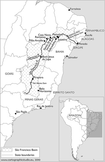
Figure 1 The extension and location of the São Francisco River and Basin in relation to the Brazilian territory.
The significance of the SFR has included spiritual, cultural, ecological, and economic elements and meanings for the local, regional, and national populations. The cultural and social concepts relate fundamentally to the watercourse being a provider of environmental goods and services for subsistence: fish, water, and the fertility of riparian zones due to the replenishment of nutrients that the muddy water of the river leaves behind after floods. The affectionate name given to the river, “Velho Chico” (Old Francisco), captures the spiritual link. Faith and mythology have been important elements in the life of the SFRB’s populations.Footnote 23
Aquatic activities have included aesthetic enjoyment, swimming, watching steamship navigation, or simply gazing at the river. The SFR in Pirapora is Minas Gerais’s beach. The state is landlocked. River transportation has been an essential service, carrying everything: cargo, cattle, salt, fibers, mail, people, and money.Footnote 24 A variety of vessels have traveled the SFR’s waters – individual canoes (canoas), two or more canoes tied together by leather strips (ajoujos), sailboats, ferries, barges, tug-boats, and ships. Manpower as oarsmen or remeiros, wood stokers on steamers, and the entire crew or vapozeiros, in combination with diesel, wind, and river currents were the driving forces behind navigation.Footnote 25 Mules in pack trains and then railroads linked the valley to the outside “developed” world.Footnote 26 In the late 1950s, Minas Gerais had the highest number of trucks in the valley. However, river navigation and animals were still the major form of transportation for the poor in the watershed area.Footnote 27 The São Francisco Basin and the hinterland of the north-east known as Sertão provided raw material and received manufactured and food products.Footnote 28 Processing and manufacture had always been a minor activity in the basin.Footnote 29
Those living in the riparian zones, beiradeiros, or on the river bank’s edges, barranqueiros, had a close link to the river.Footnote 30 In interviews, one hears how they personify the river, as described by a Pirapora fisherman: “my parents fished and grew crops with Chico”.Footnote 31 River people regarded the river as a paternal and spiritual being. As in real life, in one of his fictional literary works, Grande Sertão: Veredas, Guimarães Rosa noted a canoe man requesting the river’s blessing.Footnote 32 In his classic 1950s three-volume study of the river valley, O Homem no Vale do São Francisco, Pierson wrote about the transference of knowledge from adults to children.Footnote 33 Indeed, the basin has been the context for the formation of the identity of several river-related groups, such as fishermen, small-scale riparian subsistence farmers, and boatmen (including remeiros and vapozeiros). They shared the beiradeiro/barranqueiro values and way of life, as shown by the two illustrations from Bahia’s major daily newspaper (Figures 2 and 3). The SFRB was their universe. My interviewees said that the stream is the “soul” of those who inhabit its riparian zone.Footnote 34 The waterway was their “left and right arms”Footnote 35 and “source of life” and livelihood.Footnote 36 The “traditional ecological knowledge” that was transferred throughout generations influenced their beliefs.Footnote 37

Figure 2 Steamboat navigation in the São Francisco River. Based upon other steamboat pictures, it is from the 1930s. The steamships carried cargo, and first- and second-class passengers. Fuel occupied a large space. Steamers made frequent stops along the river to buy wood. Source: Agência A Tarde de Notícias, Salvador, Bahia, Brazil. Empresa Editora A Tarde S.A. Used with permission.

Figure 3 The Surubim fish, a prized native species of the São Francisco. The picture was republished on 30 March 1990. The reduction in population and size of this fish has been an indicator of the environmental degradation of local aquatic ecosystems. Source: Agência A Tarde de Notícias, Salvador, Bahia, Brazil. Empresa Editora A Tarde S.A. Used with permission.
Interviewees’ memories portray the SFR as a multiple-use resource. They especially mentioned its long history as a source of transportation, fish, and water. The recollections of older generations of the past sixty years depict a healthier, deeper, and richer fish- and shrimp-stocked river than today. It helped them survive even during difficult times. Droughts and inundations occurred, but locals understood the river. They reported that “floods used to bring fish”,Footnote 38 and they also knew how, when, and where to fish, farm, and navigate Chico’s waters. The interviewees have observed the environmental degradation of the river, and the trend of impaired uses throughout time (in relation for instance to navigation, fishing, and the lack of flooding of lagoons – which had allowed fish growth – and of rice fields).
Nevertheless, traditional life in riparian municipalities was full of challenges. Navigation was difficult especially during droughts and low-water seasons. Boats got stranded on sandbanks and could not access docking sites. Lack of precipitation did not allow inland rain-fed fields and reduced the yields in riparian zones. The river’s natural characteristics impaired navigation too. In some sections, namely Pirapora and Sobradinho, waterfalls and rapids formed the river’s bed and channel. Besides, silting from deforestation and agriculture worsened the problem of the creation of sediment banks, c’roas. Deficient infrastructure made small-scale growers vulnerable; when not losing their crops totally, producers needed to sell the harvest for low prices due to the impossibility of access to alternative buyers. Floods used to fertilize and irrigate the land for riparian agriculture, but extreme events also destroyed fields, towns, and urban infrastructure along the waterway.Footnote 39 Federal agencies built walls to protect the locals from the river.
As in the nineteenth century, El Niños brought droughts, thus influencing the ecology and economy in the north-east of Brazil, as in various other parts of the world.Footnote 40 During the 1877–1879 and 1951 droughts, alternatives implemented for the north-east followed the technical hydraulic approach: engineering solutions to provide access to water. The federal government funded the construction of water reservoirs in different parts of the region. Nevertheless, not many people had access to the precious resource even though the SFR was one of the few steady sources of water. The semi-arid zone covered a vast area of low demographic density. Drought relief programs did not reach everyone. Besides, the resource was often diverted into the hands of few, and distributed to people on the basis of political criteria.Footnote 41 Construction of infrastructure for public water supply on private lands exemplified these irregularities.
The 1940s’ and early 1950s’ images and studies of the São Francisco Basin’s towns and cities demonstrate the precarious access of the population to fresh water. In all too many instances, the water supply came from shallow wells, small precipitation retention reservoirs, and intermittent creeks and streams, and was produced by the labor of “aguadeiros” or “botadeiras de água”, people who collected small volumes of water from the SFR and other bodies of water and sold them to households. This activity was both a necessary part of women’s obligations and a paid occupation for others. Some cities had water delivered only to public fountains, chafarizes. Water carriers also obtained the resource from that infrastructure. They carried water in clay containers, large cans, and inside of a pumpkin-like fruit, on their head or in their hands. Mules and cattle carts carried barrels of water.Footnote 42
Already, in the 1950s, changes in water provision arrived with the establishment of new autonomous organizations.Footnote 43 Influenced by a Brazil–United States (Rockefeller Foundation) accord, and with the support of the development agency for the valley, the Comissão do Vale do São Francisco (CVSF), the federal health agency, the Serviço de Saúde Pública (SESP), implemented partnerships with the governments of several municipalities to build or improve water treatment stations, leading to the creation of independent public water providers’ systems, the Serviço Autônomo de Água e Esgoto (SAAE). Pirapora, Bom Jesus da Lapa, Juazeiro, and Penedo benefited from that intervention.Footnote 44 The Chico’s water and SAAE systems still provide the resource for those riverside towns. Other arrangements existed in several places. For example, the CVSF funded the drilling of wells to supply water to rural populations.Footnote 45
The river granted obvious, close-by forms of physical and spiritual sustenance. A local interaction of river environment and human beings existed. “The population had the natural knowledge of the time […] the fishing time, the harvest time […]”.Footnote 46 The long-term droughts, which afflict the basin every nine to twelve years, influenced the human–river environment link. The vast literature on drought and the north-east of Brazil argues that the scarcity of water drew many to riparian zones, closer to the river.Footnote 47
After the 1950s, federal policies for the north-east went beyond mitigation of the consequences of droughts and started to focus on other issues such as development, following a growth-based approach. A new understanding of the SFR was emerging. The geographical distance increased between the river and the users of its resources. In the 1950s, people in Salvador and Recife started to receive electric power generated by the SFR. The building of Brazil’s only oil production zone, outside the city of Salvador, also required electricity.Footnote 48 The eco-system service influenced the lives of individuals living far away in growing urban zones. In population terms, Recife surged in the 1950s and 1960s.Footnote 49 Federal censuses show that Salvador and Fortaleza even surpassed that city (Figure 4).Footnote 50

Figure 4 Urban population growth in three major cities of the coastal zone: Salvador, Recife, and Fortaleza (1940–1980). Source: Derived from data from IBGE, 2003.
Urban growth and industrialization created an unseen and unperceived, though strong, dependence and connection between human beings and the river environment which supplied the electrical power. In 2001, such strong dependence still existed when a drought caused a water shortage and led to urban blackouts and a mandatory electricity consumption reduction program.Footnote 51
In addition to the policies for the north-east, the federal government planned major programs for the valley based upon its economic development even before 1950. In the late 1930s during the New State (Estado Novo), President Vargas saw the valley becoming “Brazil’s economic spine”. The watershed would include, besides river traffic, new roads and railways. Some saw the plan as a means to nationalize Brazil’s wealth.Footnote 52 Despite all the political rhetoric, no changes took place during the 1930s. World War II caused a spike in the river’s importance. The waterway became the only safe water transport link between the south and the north of the country during the war, as German U-boats attacked Brazilian coastal ocean shipping.Footnote 53
Hydro-Businesses
Eco-systems support a wide range of human uses. In turn, those applications influence natural processes again. In the Brazilian Amazon the national government redefined and changed how locals used natural resources to employ them for developmental purposes.Footnote 54 If one compares the Amazon and the São Francisco Basin, in both cases the waterways used to be an integral part of the life of riparian communities. They used the river for fishing, natural irrigation, the fertilization of riparian lands, and for transportation. Interference from agents external to those systems produced destructive impacts – relocation of people and the elimination of areas of riparian agriculture resulting from the construction of dams and reservoirs. State development strategies redefined the Amazon, causing a move away from traditional historical roles of basic direct subsistence and into bauxite mining and hydro-power activities, turning small communities into boom towns. In the case of the SFR, the hydro-businesses of power generation and irrigation redefined and reshaped the natural system profoundly.
Hydro-power has played an important role in the provision of electricity for the nation. Before the 1920s, manufacturing depended on accessible water power, but in the first two decades of the twentieth century few had observed the nation’s natural potential, as described by the following sentence: “There is enough hydraulic force available in Brazil to turn the wheels of the world but the majority of these wonderful cascades are scarcely known by name.”Footnote 55
By the 1950s, electricity shortages and a growing demand for energy were a challenge for Brazilian development.Footnote 56 Energy policy aimed at assisting the industrial development of the nation. In the north-east, governmental programs in the form of fiscal incentives, income tax exemptions, and public credit attracted industrial investment to major cities, such as Salvador and Recife. With the exception of the metropolitan area of Belo Horizonte and Pirapora in Minas Gerais state, Juazeiro in Bahia, and Petrolina in Pernambuco, industry was never the strong sector of the valley, though energy was.
Paulo Afonso I, the first station producing electricity on a large scale in the SFRB, went online in 1954. Through power lines, electricity started to flow outward from the valley in the same year.Footnote 57 The station initially provided hydro-power to Pernambuco and Bahia. The north-east continued to expand its infrastructure, especially roads and electrical energy.Footnote 58 In the 1960s, hydro-power provided over 65 per cent of the nation’s electricity, a share which steadily grew. Figure 5 displays both total Brazilian energy production and the proportion accounted for by hydro-power.Footnote 59 In the 1970s alone, four new stations started producing energy using the Velho Chico.

Figure 5 Electric power production in Brazil by source, 1952–1987, in gigawatt hours (GWh). Source: Derived from data from IBGE, 2003.
Nine dams control the river’s flow. As with the other dams, Três Marias, the most upstream barrier holding back Chico’s water, was intended to manage flooding, improve navigation, and make possible large-scale irrigation and hydro-power generation.Footnote 60 However, electricity became the principal output, followed later by water for irrigation. The damming of the SFR had quickly shifted from multiple to these dual purposes. Hydro-power infrastructure transformed the river and valley, managing the water’s flow and assigning large areas of the valley as artificial lakes. The changes influenced irrigated agriculture, which helped support Brazil’s role as an agro-exporter.
As already mentioned, Brazil’s transnational economy has its roots in the nation’s colonial past.Footnote 61 The São Francisco Basin was connected with the global economy in a variety of ways before World War II. For example, at the end of the nineteenth century the region provided hides to the United States and Germany, and goat skins for ladies’ gloves, book binders’ leather, and high-grade shoes.Footnote 62 Some thirty years later, a critical raw material of the valley, commercial quartz (silicon dioxide) crystal, was exported to Europe and the United States. Brazil was the only supplier of quartz, a component in the fabrication of radio station frequency controls, telephone equipment, lenses, and precision instruments.Footnote 63 After the war, scientists at Westinghouse Electric learned how to grow quartz crystals, ending the need for Brazil’s natural ones. Locals also collected the wild-growing caroá cactus (Neoglaziovia variegata) for fibers. During World War II, the United States imported the fiber for the production of cordage, paper, cloth, and bags.Footnote 64
Brazil exported agricultural products partly to obtain foreign exchange.Footnote 65 Between 1961 and 2007, with the exception of 1979 and 1986 when Brazil fell behind Colombia, the nation was the world’s leading coffee exporter. It was the number one exporter of raw sugar by volume from 1998 to 2007.Footnote 66 By the 1980s, a new group of Brazilian agribusiness billionaires had emerged which included some from São Paulo: José Cutrale and Carl Fischer, producing orange juice, and the soybean king, Olacyr Francisco de Moraes.Footnote 67 During the 1970s and 1980s, in the Petrolina-Juazeiro zone of the SFR Valley, the more resource-intensive and large-scale irrigated production of tomatoes, sugar cane, and fruit was launched.Footnote 68 In the late 1980s, almost half of the irrigated land of the basin was in this zone.Footnote 69 Fruit juice and extracts from that agro-industrial area supplied the markets of a number of countries, including France and Switzerland.Footnote 70 In 1987, grapes and mangoes from the valley began carving out a niche in the international market.Footnote 71 The Netherlands, the United Kingdom, and the United States became important buyers.Footnote 72 Soybeans completed the list of the valley’s export products.
Several conditions favored agricultural production in the region. The low price of land and low cost of labor gave the north-east advantages in relation to other parts of Brazil and the rest of the world.Footnote 73 In addition, the São Francisco Basin had a high annual temperature and bright sunlight.Footnote 74 Lastly, the river’s water was a free natural resource for producers in the valley. In practice, free water kept prices of agricultural products low. The main costs related to infrastructure, such as powering the pumps used in irrigation.
By 1960, 10,800 hectares of the SFRB had been irrigated. By 1999, that figure had risen to 333,000 hectares (Figure 6), representing an average annual growth rate of 9.2 per cent for that 39-year period.Footnote 75

Figure 6 Irrigated land in the São Francisco River Basin. Source: Derived from data from CODEVASF, 2008.
Irrigation allowed agricultural production beyond riparian and dry-land agriculture (tradicional agricultura de sequeiro).Footnote 76 Production became less dependent on the variability of the rainy periods. Irrigation permitted crop diversity, as well as spatial and temporal changes such as the location of the area of production and the time of the growing season in relation to the year. It transformed the landscape (Figures 7 and 8). Perennial and annual crops and water canals contrasted with the xerophytes and deciduous thorny scrub and trees of the semi-arid region.

Figure 7 A vineyard at a private enterprise in Petrolina, Pernambuco, Brazil. Fruit culture is an important activity of the valley and grapes and mangoes are major products. Photograph by Lucigleide Nascimento, 2007.
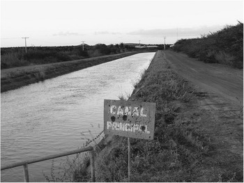
Figure 8 The main water canal which is an important infrastructure of an irrigation scheme. This publically built canal is located in the lower-middle-SFR in the municipality of Petrolina, Pernambuco, Brazil. Photograph by Lucigleide Nascimento, 2007.
Small-scale irrigated agriculture of onions and maize had operated in the riparian zones of the SFRB in the 1950s.Footnote 77 During 1950 and 1952, the CVSF, a development agency for the watershed, had financed 1,250 engines to pump water from the SFR to irrigate riparian land, especially in Bahia and Pernambuco and in the lower SFR.Footnote 78 Hydro-power infrastructure, electricity, and the construction of canals, such as the one in Figure 8, and pumping stations made possible the existence of larger-scale irrigation systems.Footnote 79
Since the 1960s, the Companhia de Desenvolvimento dos Vales do São Francisco e do Parnaíba (CODEVASF), successor to the CVSF, and other federal agencies have been building the structural foundations for agro-industrial complexes in the valley.Footnote 80 According to a former Bahia Federal Deputy, Manoel Novaes, the projects were well planned, and were intended to boost the production of food and create jobs to meet local needs.Footnote 81 However, the projects had hidden costs, such as the overuse of water, run-off of fertilizers, salinization of soils, and ultimately a choice of products for export rather than local needs. The area in the north-east that used to grow traditional products (cotton and cassava for instance) has decreased since the 1970s.Footnote 82 In the São Francisco Valley, the higher world market prices have led to an increase in the production and importance of non-traditional crops, such as fruit (mangoes and grapes for example), raw produce for food processing (tomatoes for instance), and sugar cane.Footnote 83
In the governmental irrigation zones, producers paid a water bill, but it covered only the use of infrastructure and not the water itself. In practice it acted as a subsidy to lower the price of agricultural products. As already mentioned, only the costs of infrastructure in governmental irrigated areas, such as the price for the electricity used to deliver the water, was charged. The 1997 Water Policy authorized payment for the use of water resources, but the system for the SFRB has not been fully implemented.
The area of land used for extensive cattle ranching declined.Footnote 84 Irrigated agriculture reshaped and created vulnerability in the valley.Footnote 85 The dependence on international markets made the valley susceptible to global crises and fluctuations in the level of demand and price. It exposed the system to international market forces and product requirements.Footnote 86 The new human uses of the valley’s water have reconceptualized the good and the bad. The lack of rain was unfavorable for inland agriculture, demonstrating the vulnerability of locals to drought.Footnote 87 It also reduced the yield in riparian zones because of the decrease in the size of the area subjected to inundation, leading to a poor agricultural season. But in the irrigated, controlled model of agriculture, rain became an uncontrollable variable that can damage agricultural production.Footnote 88 Rains disrupted the planned nature of irrigated agriculture.
Migration And Forced Migration
At the end of the nineteenth century, north-easterners migrated to the Amazon during the rubber boom.Footnote 89 In the 1950s and 1960s, people left to join the labor forces of São Paulo and Rio de Janeiro and to build Brasília. Indeed, following the trend of the broader region up until the 1960s, population movement in the SFRB had been mostly outward. This outmigration was initially spurred by the recurrent devastating droughts, concentrated land ownership, and prevailing agricultural production models, then by the prospect of wage labor in urban construction and by the hope of higher living standards. Environmental refugees also sought water and shelter in the cities. Migration worsened social conditions in metropolitan zones, leading to the spread of shanty towns.Footnote 90
In the 1950s, the number of individuals born in the north-east but living outside of it grew at an annual rate of 8.8 per cent, more than twice the corresponding rate of 3.7 per cent in the 1940s. The lower SFRB lost significant population in the 1950s and 1960s.Footnote 91 On the other hand, the north-east did not attract significant migratory inflows from other regions, except from Minas Gerais and Espírito Santo. In 1970, 99 per cent of the population in the north-east had been born there.Footnote 92
The rural–urban migratory stream dominated in the areas of the middle and lower-middle SFRB during the 1960s.Footnote 93 In the north-east, rural to urban migration continued during the 1970s and 1980s. Commerce and services attracted migrants to urban zones between 1980 and 1995, despite an economic crisis that hit the urban industrial sector harder than other areas.Footnote 94
Migration is also associated with other causes. In some parts of the valley, the introduction of the new development approach of hydro-business destroyed the local social order of traditional ranching and agriculture, commerce, and fishing towns. The development-induced displacements disturbed the local way of life, forcing migration and adaptation to new ways of living, disconnected from the river. Hydro-power management altered aquatic eco-systems and the zones which used to be naturally subjected to the seasonal rise and fall of the waters in riparian agriculture. Irrigation led to rising land values, often resulting in expropriation. The new model altered the existing work relations in the agricultural sector by reducing or eliminating older tenancy systems. Displaced smallholders moved to cities.Footnote 95
Good examples of this tragic situation are provided by the Sobradinho and Itaparica dams, which required the resettlement of about 65,000 and 50,000 people respectively.Footnote 96 The construction of the Sobradinho caused the relocation of four towns: Remanso, Casa Nova, Sento Sé, and Pilão Arcado. Few people ended up in the places in which they were supposed to be resettled.Footnote 97 A new way of life was imposed as riparian inhabitants resettled into inland areas. “A lot of people who used to live from onion and garlic production […] in [seasonally inundated] fertile soils in riparian areas […] needed to change the production system […]. They had to shift to another activity, such as goat herding.”Footnote 98 Another interviewee said that, “once these people were sent to Caatinga […] their numbers swelled the cities […]”.Footnote 99
In the case of the Itaparica dam, not all displaced residents received compensation. Given the informal traditional social system in which had they lived, they could not prove land ownership. The social and economic conditions of those the government resettled also often deteriorated. It took seven years for them to receive irrigation equipment to be able to farm the new lands. Violence and alcoholism increased in the community.Footnote 100
As Hilton observed, the implementation of governmental projects would save migrants a long walk to São Paulo.Footnote 101 Irrigated agriculture attracts many to development “poles”. Few find permanent work, forming a contingent workforce which finds jobs only seasonally. “Elsewhere in the region, on the periphery of the urban settlements of Petrolina and Juazeiro, settlements grew up to house the influx of migrants who formed the primary labor supply for most farms.”Footnote 102 But the number of people who arrive every day is higher than towns and cities can support.
Environmental Change And Ecological Sustainability
Ecological sustainability is critical to the long-term health and survival of both humans and non-humans.Footnote 103 Ecological sustainability requires maintaining the integrity of natural systems.Footnote 104 The protection of eco-system health and integrity means respect for the system’s carrying capacity and its resilience to stress. It also implies recognition of possible limits, and prevention of future damage.Footnote 105 In the SFR case, this also means addressing water pollution and the destruction of aquatic populations, creating conditions for annual inundation to occur, as well as taking action to prevent new threats to the river’s ecological sustainability.
Individual and cumulative effects on the river eco-system are many. River users, managers, and researchers from different localities have noticed the multiple changes during the last sixty years. Taking a holistic approach and comparing present with past conditions, the river has been categorized as a “sick” being or even a “dying river”. Some predict that it will become a temporary river, as have many others in the semi-arid region which flow only during the rainy season. The threats to the sustainability of the SFR derive from, inter alia, the construction and operation of hydro-power infrastructure, urbanization and population growth (and their effects, such as the increase in raw sewage discharge), industry and mining, and agriculture and deforestation (cause and consequence). The focus here is upon electricity and irrigated agriculture, which are the forms of hydro-business in the valley.
Dams hold back water and sediments. An eighty-three-year-old retired boat worker, who also used to grow rice in Brejo Grande, beautifully described the changes in the river and what now takes place in the lower SFR:
When there were floods, the entire region was full of fish, because fish and shrimp used to come. The water flooded lagoons with that yellow water, vitamin rich, which resulted from the mud [the water] removed from the river’s banks. […] People grew rice […]. It produced important rice. Today the water seems to be filtered, isn’t it? The water is kept by the dam. When the dam lets the waters go […] the water comes clean, without the vitamins.Footnote 106
The staff of water treatment plants in the region of the lower SFR noticed changes too, including a reduction in the level of suspended sediments.Footnote 107 The management of the river for hydro-power generation reduced the occurrence of natural floods which used to increase the level of the river seasonally and maintain riparian lagoons. Now dams prevent the flooding of such riparian water bodies.Footnote 108 In the middle SFR, starting in Pirapora and in the lower SFR, the river is surrounded by lowlands that floods used to transform into lagoons.Footnote 109 Fishing boomed in such an aquatic environment.Footnote 110 The middle SFR including Bom Jesus da Lapa was an intensive fishing center. In 1968, fishermen caught 215 tons, in 1969 the figure was 385 tons, and in 1970 the catch amounted to 366 tons of fish.Footnote 111 These numbers show the importance of the activity for the town and region.
The lack of periodic inundation inhibits fish from entering and exiting riparian lakes.Footnote 112 It isolates those water bodies from the river’s main channel for long periods and prevents migratory fish from returning to spawning sites.Footnote 113 The dam itself also impairs fish migration. Many species of the SFR are migratory; they include surubim (Pseudoplatystoma coruscans).Footnote 114 Fish populations have decreased. Changes in species composition have also been observed. Surubim has become an endangered species, and tucunaré (Cichla spp.), an invasive species, now dominates the river’s waters. Locals do not know how the tucunaré first arrived in the SFR. It is an aggressive fish that preys on other species. In Três Marias reservoir, small-sized fish declined significantly after the introduction of tucunaré.Footnote 115
The changes in fish populations have compromised the livelihood of those who depend on the river’s resources. All along the SFR, especially in the middle SFR, fishermen supported local and regional markets. They formed a homogeneous group sharing social and occupational identities. They behaved in similar ways and shared similar life objectives. The destruction of fishing means the annihilation of their former way of life. In bad agricultural seasons, the inhabitants of riparian cities will fish for food and also to sell if agriculture cannot support them and their families.Footnote 116 A natural bias toward seeking subsistence from the river existed in the past, but environmental changes have increased this tendency.
The destruction of the traditional culture of fishermen does not imply that people do not fish for their sheer survival. Locals have noticed an increase in the number of fishermen.Footnote 117 In 1985, about 26,000 fishermen fished on the SFRB,Footnote 118 but many do not share the identity of the professional groups of the past. They fish for subsistence. “Today, it is difficult to sell [the fish]. There are more fishermen than buyers.”Footnote 119 In various regions of the SFR, fishermen are confident that many people fish now for lack of choice, while others are still proud of their traditional way of life. For them, the river is like a good boss.Footnote 120 Unemployment, water pollution, the destruction of habitat due to the deforestation of riparian forests and the land filling of lagoons for urban and agriculture purposes, and overfishing have visibly impacted fish, fishing, and fishermen.
At the beginning of the twentieth century, an endless conflict between the river and the sea took place at the SFR’s mouth.Footnote 121 The volume of water was high and swept the river’s silt into the ocean. This fact did not eliminate the formation of islands and sandbanks near the SFR’s mouth.Footnote 122 Today, the water is without the “vitamin”, as a local from a municipality at the mouth of the SFR explained. It is “hungry water”; the sediment-starved flow sculpts the landscape, eroding, transporting, and depositing sediment.Footnote 123 At the river’s mouth the load of sediment is reduced, and sea waves now accelerate beach erosion.Footnote 124 As a result, the small oceanside village of Cabeço has been completely washed out to sea.
Change in salinity affects species that grow in riparian zones. Saltwater destroys junco (Eleocharis elegans), a fiber-rich grass, and rice plantations. Two species of maçunim, shellfish, existed: one freshwater sort and the other saltwater. In the lower SFR, families spent time collecting maçunim on the beach up from the mouth of the river.Footnote 125 Now the salinity of the water is demonstrated by the catch of saltwater species in areas in which they were not common in the past.
Irrigated food production affects the natural system in both hydrological and ecological ways: subtracting nutrients, depleting and salinizing soils, polluting air, soil, and water due to the run-off of fertilizers and pesticides.Footnote 126 A 2002 analysis based upon qualitative information provided by environmental managers reported that about 38 per cent of the municipalities which comprise the SFRB suffered water pollution from three major causes: domestic sewage discharge, solid waste, and the use of agro-toxins and fertilizers.Footnote 127 As with irrigation, fertilizer consumption in Brazil has been increasing since the late 1960s. It jumped from 270,004 metric tons in 1961 to 7,682,000 in 2002.Footnote 128 Fertilizers are used in intensive agriculture, such as in fruit production in the north-east of Brazil. If improperly or over used, nutrients such as nitrogen can contaminate the water. Phosphorus causes eutrophication and depletion of oxygen in water bodies and the death of animal aquatic life and the impairment of human uses. Intensive irrigated agriculture has resulted in the salinization of soils in the valley and waterways. In the Petrolina region, the water treatment plant uptake is downstream and close to a creek which crosses irrigated land. During winter, the salinity content is particularly high.Footnote 129
Hydro-business in the SFRB has heightened the importance of analyzing trade-offs and opportunity costs. As in the case of the redefinition of the meaning of the Velho Chico for hydro-power and irrigation, the consequences are both impaired (negative effect – NE) and improved (positive effect – PE) uses of the SFR’s waters (Figure 9).

Figure 9 This matrix shows how the two major uses of the São Francisco (to generate electricity and to irrigate agricultural fields) can affect positively (PE), negatively (NE), or both, other uses of the eco-system services of the water body (e.g. navigation and fishing).
NE1: In the Sobradinho Reservoir, the new environment to provide electricity impaired navigation of older-type boats because the lake was too windy. The river was not regulated for navigation.
NE2: Electricity impaired fishing. Hydro-power infrastructure transformed the flowing river into a sequence of managed lakes. It spoiled fish migration and their reproductive cycle. Producing electricity caused a decrease in the populations of fish, in the lower SFR for instance, because those populations cannot replace themselves in the altered habitat.
NE3, NE7: The management of electricity and irrigation created concerns for public water supply, as in Penedo in the lower SFR, when air entered the water treatment plant system because the river’s level was too low.Footnote 130 In Petrolina, intensive agriculture is a source of contaminants in pre-treatment drinking water.Footnote 131
NE4: Electricity impaired traditional agriculture. The level of the river is no longer based upon natural conditions, but upon human management. Locals cannot apply their traditional knowledge to assess when the river will be high or low and when is the right time to farm and harvest.
NE5, NE6, NE7: Water withdrawn for irrigated agriculture might restrict and/or impair other uses, such as the maintenance of water to allow ecosystem life and for hydropower generation. In the basin, this use already impacts navigation and water supply for domestic uses. The Rio Salitre used to be a permanent tributary, the Rio Corrente had more flow in the past, and Minas Gerais’s brooks and creeks are disappearing due to the intensive use of the water. Locals complained about the reduction in the flow of the tributaries and the contribution to the SFR. As one fisherman said, “as we need our arms, we need our legs, we need our head to govern our body; in the same way the big river needed its arms, the rivers that formed it”.Footnote 132
NE8: In future, managers will need to choose between one or the other use, water for irrigated agriculture or for electricity generation. For example, if the inter-basin water transference project (Transposição) of the National Integration Ministry takes place as proposed, the scheme will reduce CHESF’s hydropower production by 2.4 per cent.Footnote 133 The idea for this project has existed since the time of the Brazilian emperor D. Pedro II (1840–1889). The current inter-basin project has kindled both public support and opposition, including two hunger strikes and several court cases. This new large-scale infrastructure traversing part of the basin and other regions of the north-east involves northward and eastward running canals with a total of 720 kilometers of aqueducts, reservoirs, dams, and pumping stations, which will increase hydro-business. The project exemplifies what Richard Burton noted in the nineteenth century, namely that Brazil has had a bias toward monumental constructions since times past.Footnote 134
Climate change is another consideration relating to water use and choices in the valley. Scientists agree that changing climatic conditions will affect hydrologic cycles.Footnote 135 But the impact of those changes and our ability to cope with the problems they cause will not be distributed evenly around the world.Footnote 136 They might trigger extreme events such as droughts and floods, increasing or decreasing river flows, evaporation, precipitation, and infiltration. The valley is already a water-deficit zone.
NE9: Irrigated agriculture might in the future create opportunities for beneficial effects, such as aesthetic enjoyment. The visit to wineries is still an incipient activity in the Petrolina and Juazeiro regions. The negative effects are more visible in the case of Pirapora, with tourist attractions in the waterfalls area – such as the beach at Minas Gerais – being impaired.
NE10: Irrigated agricultural fields replaced areas of traditional crops and agriculture.
NE11: A limit exists to the extension of land and the size of production the SFR will be able to irrigate.
PE1: The construction of electricity-generating infrastructure, namely dams and reservoirs, improved river navigation when navigation was a high-priority use, as for example in Pirapora during the non-rainy season soon after the construction of the Três Marias dam. Then, energy became the most important river use, and the water body management focused on that.
PE2: A series of power stations and reservoirs along the river’s course resulted in a better managed, fuller use of the river’s flow for electricity generation.
PE3: Electricity improved flood control. Extreme floods used to submerge towns and cities more often. Now, flooding occurs only if it does not impair hydropower management priorities.
PE4: Electricity has created new means of recreation in the valley. For example, residents and tourists use the Paulo Afonso hydro-power infrastructure for aquatic sports and sunbathing on a sand beach, Prainha. The city is famous for its eco-tourism and new forms of sport. The bridge, which links Alagoas and Bahia and is supposed to save the population in the event of a dam-related disaster, is popular among bungee jumpers and rappellers.
PE5: Electricity improved irrigated agriculture. The construction of water reservoirs assured a steady supply of water and electricity to power the pumps.
Conclusion
The beginning of the 1950s marked a new phase in the valley: dams altering production in riparian zones, water management for hydro-power generation controlling the flooded area, and the federal government creating opportunities for irrigated agriculture in development zones. The redefinition of the uses of the SFR for hydro-power and irrigation imposed upon locals threatened their identity as barranqueiros and beiradeiros, making their living as riparian fishermen, boatmen, and subsistence farmers more difficult. The environmental changes impaired traditional uses, namely for fishing and riparian agriculture. The new values did not correspond to the realities of their society.
Hydro-businesses favored the production of crops for export, such as fruit and soybeans, which supports Brazil’s international position as an important agro-exporter at the expense of meeting the demands of local people. Large-scale hydro-business does not address the needs of subsistence farmers and other local groups. The introduction of such a form of production tends to deepen the disparity between lower and higher economic classes. Few small farmers, tenants, and sharecroppers have benefited from the hydro-businesses of the late twentieth century. As one group of fishermen and fisherwomen put it:
A lot has changed, including the harvest we used to collect from the riparian zone where we used to grow crops after big floods. We produced a lot of cassava, watermelon, pumpkins, beans, and everything else. That came to an end […]. Such floods [natural ones] do not exist anymore […] the richness of food ended too […].Footnote 137


