


Introduction
Reccopolis, located on Oliva Hill near Zorita de los Canes (Guadalajara, Spain), was a new city built by the Visigothic king Liuvigild (r. 568–86). The site is a unique example of an ex novo urban foundation in the post-Roman West. As such, it is a perfect case study for the ideas and ideals of a city in long Late Antiquity, many of which were taken directly or adapted from the classical, Roman model. The site was discovered in the 1890s, but excavations only began in the 1940s under Juan Cabré. Regular excavations have continued ever since, revealing most of the monumental area inside the walled enclosure.Footnote 1 One of the most surprising elements of the site is its aqueduct, identified 2 km to the east.Footnote 2 This aqueduct was the first new, urban aqueduct built in the Iberian Peninsula in two centuries, and it was the last one built in the Roman way. It was built at a time when large construction projects in the West as a whole were rare enough to make this water conduit a unique feat of Late Antique engineering. While much has been written about Reccopolis itself and its importance in Visigothic and Late Antique urbanism, there is still much we do not know about the city because of the limited extent of the excavations. One of these unanswered questions has been the nature of the city's water cycle, which derives entirely from Roman urban hydraulic principles.
In this paper, we will present an updated and integrated study of the water cycle in Reccopolis, its supply, use, and disuse, paying particular attention to the aqueduct. The study will be based on the physical remains surveyed and excavated in and around Reccopolis, considered alongside both GIS analysis based on LiDAR-generated Digital Elevation Models (DEMs) and hydraulic engineering calculations. Much remains hypothetical in our understanding of the hydraulic cycle in Reccopolis, but given the presence of the aqueduct, the data that can be calculated from it, and what we know about water in the Late Antique and post-Roman city in the West, it will be possible to propose an almost-complete synthesis of the water system, and then contextualize Reccopolis and its water supply and drainage systems against the background of Roman, Late Antique, and early medieval water culture. While an important propagandistic and prestige element was attached to aqueducts in Late Antiquity (attested above all in Procopius and Cassiodorus), in Reccopolis the aqueduct was more than that: it was an integral part of the urban fabric and a determining factor in city life. This central role of the aqueduct casts an interesting light on ideals and ideas of a “City” in the late 6th-c. West.
The city of Reccopolis
Our only source about Reccopolis and its construction, the Chronicle of John of Biclar (later abridged by Isidore of Seville), mentions that Liuvigild built a city in the year 578 in the province of Celtiberia after a series of successful military campaigns. It also mentions that the king endowed the city with monuments and privileges, and that he named it after his son, Reccared (r. 586–601).Footnote 3 The foundation (or, more likely, the inauguration) coincided with Liuvigild's decennalia, his ten-year celebration. It was evidently an exercise in royal propaganda, meant to highlight the power of the Visigothic monarchy and aimed at both Liuvigild's own subjects and his foreign (Merovingian and Byzantine) rivals. From a more practical perspective, the city was built to impose firmer central control over the largely de-urbanized province of Celtiberia, which was at the edge of the territorial limits of the old Roman towns of Ercavica and Caraca.Footnote 4
To date, excavations have focused on the upper city, the walls, and the large “palace-complex” and its surroundings, although many more areas have been revealed through geophysical survey.Footnote 5 The results of these studies have shown a city similar in many ways to other Late Roman and Late Antique foundations, with many elements taken from or imitating earlier Roman practices. At the same time, the indicators of change that denote the early medieval city can be perceived at Reccopolis. The palace complex consists of a series of large, aisled structures and an apsed basilica, built around three sides of an open plaza on the top terrace of the hill. All of these structures can be dated to the late 6th c., are built with mortared rubble, and have floors paved with opus signinum and tiled roofs. Access to this plaza was through a commercial street, flanked by workshops and shops. At a later stage, early in the 7th c., access to the plaza was modified with an arched gate and a series of buildings that abutted the basilica and destroyed earlier structures. Large houses have been excavated both to the east (area 15,500) and to the west (areas 16,000 and 17,000) of this street, and were also modified during the 7th c.Footnote 6 Beyond these features, geophysical surveys have shown that the area behind the basilica and the palace, towards the east, was occupied by large, self-enclosed buildings. The rest of the hill was densely packed with less well-defined buildings along the main street axes (Figs. 1 and 2).
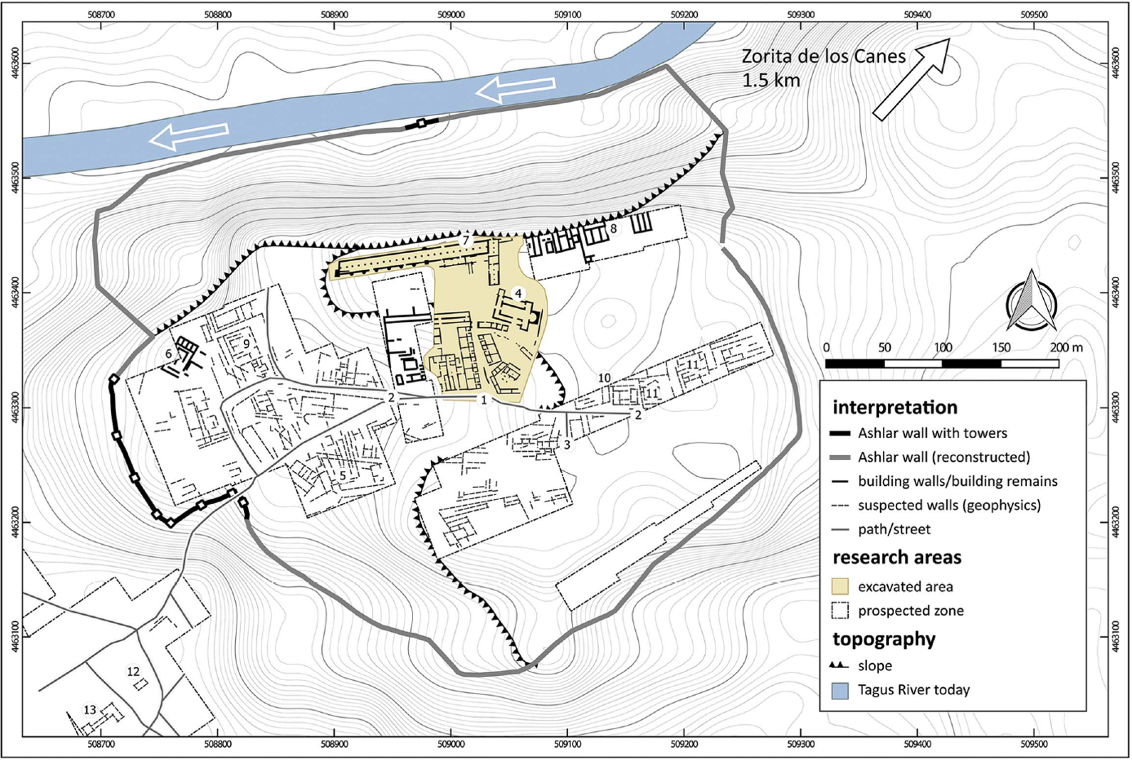
Fig. 1. Plan of Reccopolis, including the excavations and the areas identified through geophysical survey. (Henning et al. Reference Henning, McCormick, Olmo Enciso, Rassman and Fikrit2019, fig. 3.)
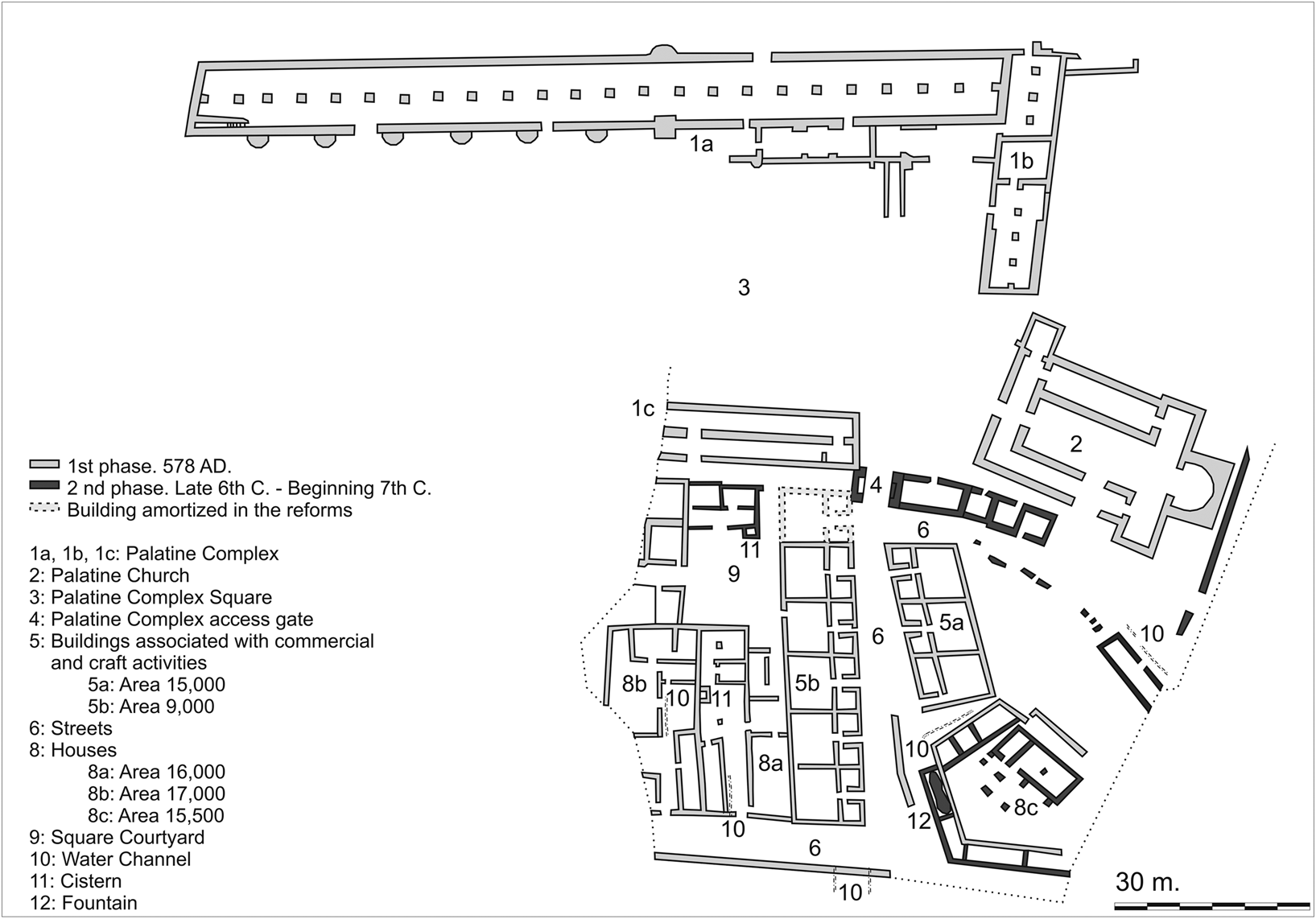
Fig. 2. Plan of the Reccopolis excavations including the water-related structures and the first two phases. (Based on Olmo Enciso et al. Reference Olmo Enciso, Castro Priego, Checa Herráiz, Gómez de la Torre-Verdejo, Perlines Benito and Hevia Gómez2017).
Even though Reccopolis lacks an orthogonal street grid, it is clear it was built following a planned design, one that would reflect the urban values of its time while also fulfilling the expectations of the settlers.Footnote 7 The city is laid out along the main avenue that connected the gates with the plaza and the palace complex. The excavators equated this axial development (gate-commercial avenue-entrance-palace) with that of Constantinople.Footnote 8 The city lacks some of the amenities that would usually have characterized newly founded Roman cities (most notably, buildings for public entertainment), but this is a reflection of Christian contemporary expectations and post-Roman urban practices: in Reccopolis we find walls and a Christian basilica, repeating a model that can be seen in other Late Antique foundations like Dara/Anastasiopolis or Justiniana Prima.Footnote 9
The identification of Reccopolis with the ruins of Zorita is almost certain, and the excavations have revealed that the foundation was not just an act of propaganda: the city was inhabited throughout the Visigothic period, it was an active administrative center, possessing a mint, and it was a glass production site. Reccopolis was a functional city into the Islamic period; it was not a renaming like Theodoricopolis or an ephemeral foundation like Charlemagne's Karlesburg. The city only dwindled when the economic focus shifted to a newly established military-administrative Umayyad settlement at the site of modern-day Zorita. During this period, there is a clear transformation of the urban fabric, but the Visigothic city was only burnt and abandoned in the mid-9th c., almost three centuries after its foundation.Footnote 10
Water supply
For all we know about Reccopolis through excavations and survey (including elements related to its water supply), the site's hydraulic infrastructure has so far received very little attention.Footnote 11 A city built near a river but on a hill would have necessarily had to rely on sources other than wells, but excavations have shown that the distribution and storage of water in the city might have been centralized.
The Reccopolis aqueduct
The Reccopolis aqueduct is an impressive feat of Late Antique engineering and a unique example of new Roman-style aqueduct building in the post-Roman West. While remains of the aqueduct were first recorded in the 1980s, its course was not properly documented and surveyed until the 2010s (Fig. 3).Footnote 12
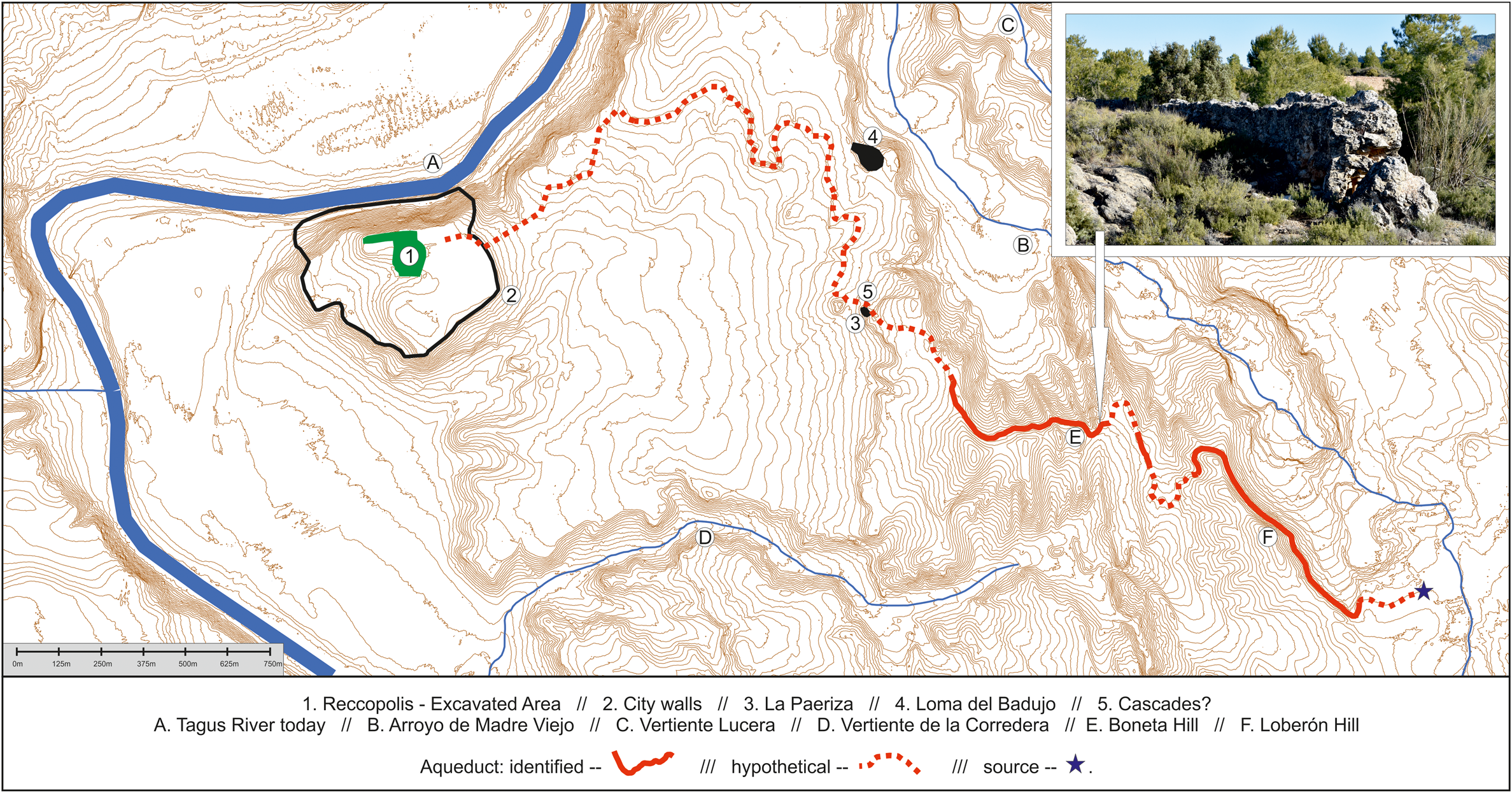
Fig. 3. Map of the Reccopolis aqueduct, highlighting the identified course (full line), the hypothetical course (dotted line), and the main relevant sites mentioned in the text. (Image by the authors.)
The conduit diverts water from a nearby river (the Madre Vieja). A diversion dam that is still in use, linked to an abandoned irrigation conduit now used as a terrace, are probably the first sections. Then the conduit turns north along Loberón Hill, hugging the contour lines and following a gentle slope for some 830 m, descending a total of 14 m – this means an overall gradient of 16.87 m/km, but with slopes on the identified sections of 9.5 m/km (Fig. 4a). More remains of the aqueduct are located at Boneta Hill, 140 m to the west. These have dropped some 9 m in height, so it is likely that in order to keep the gradient to the minimum, the conduit took a longer course to the south before turning north again. The next remains on Boneta Hill are 165 m to the northwest. Up until this point, all the preserved remains were limited to the foundations of the substructio or remnants of the specus visible on the surface, but here we find parts of a wall up to 2 m high and pillar foundations that would have supported a small arched section (Fig. 4b). From this point on, the aqueduct continues along the hill, possibly coinciding with a structure that was visible in 1950s aerial photographs but had disappeared by the time we carried out the pedestrian survey. The conduit is later visible under the modern dirt road and at the site of La Paeriza (Fig. 4c). This last section only descends 4 m over 550 linear meters, resulting in a gradient of 7.27 m/km. La Paeriza is also the site of a small (0.5 ha) set of structures built along the main road that connected Reccopolis with Segobriga and, from there, the Mediterranean coast.Footnote 13
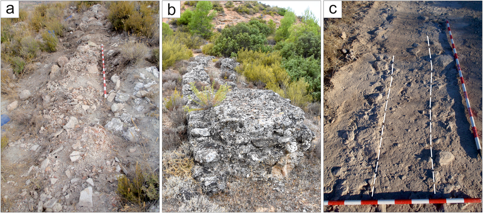
Fig. 4. Remains of the Reccopolis aqueduct a) at Loberón Hill; b) at Boneta Hill; and c) identified inside the road at La Paeriza. (Images by the authors.)
Beyond the remains at La Paeriza, the course of the aqueduct becomes completely hypothetical, and the difficult terrain makes reconstructing the path even more challenging. Once it went out of use, the aqueduct was most likely dismantled and the materials reused in the construction of the Umayyad castle and settlement of Zorita – a fate shared by most of the carved stones of Reccopolis.Footnote 14 Any surviving remains were likely destroyed as a result of intensive agriculture in the 20th c., so that no visible remains have been identified despite extensive surveying. However, using a cost surface analysis that could reflect the friction parameters that characterize aqueduct routes (including preference for continuous, gentle slopes and the impossibility of going uphill), based on a LiDAR-generated DEM from the Spanish National Geological Institute (IGN),Footnote 15 it has been possible to reconstruct the course of the aqueduct up to the potential location of the castellum, at the highest point of Reccopolis hill. This reconstruction is slightly different from the one proposed in 2015.Footnote 16
This new reconstructed course requires the existence of a system that would allow the aqueduct to descend 30 m in under half a kilometer. Aqueducts in Roman times sometimes used cascades or pressure shafts, like those known from the aqueducts of Córdoba, and it is not unreasonable to suggest these were used in Reccopolis.Footnote 17 Furthermore, the large masonry buildings identified at La Paeriza (Fig. 5), which are made of similar mortar rubble and form linear structures,Footnote 18 might have been part of this system.Footnote 19 The next section, which makes a 1,500 m-long curve along the hillside, would have had a much gentler gradient of 5.3 m/km, which is to be expected considering the parameters established in the GIS cost surface analysis. The question remains as to how (and where) the aqueduct entered the city. Considering the alignment of some existing paths and the presence of linear features in the 1950s aerial photos, the solution might have been an arched bridge, some 620 m long and up to 16 m tall – or possibly lower if an inverted siphon was employed. Both options (bridges and siphons) had been used in Roman aqueducts in the past and were still used by coeval Byzantine engineers in the East.Footnote 20 The siphon was the riskier option, engineering-wise, especially considering the estimated height of the bridge, but either solution would have resulted in an impressive structure, seen by everyone entering the city from the east: a reminder of Liuvigild's power and wealth. This structure could have been one of the mira opera suburbana mentioned in John of Biclar's chronicle.
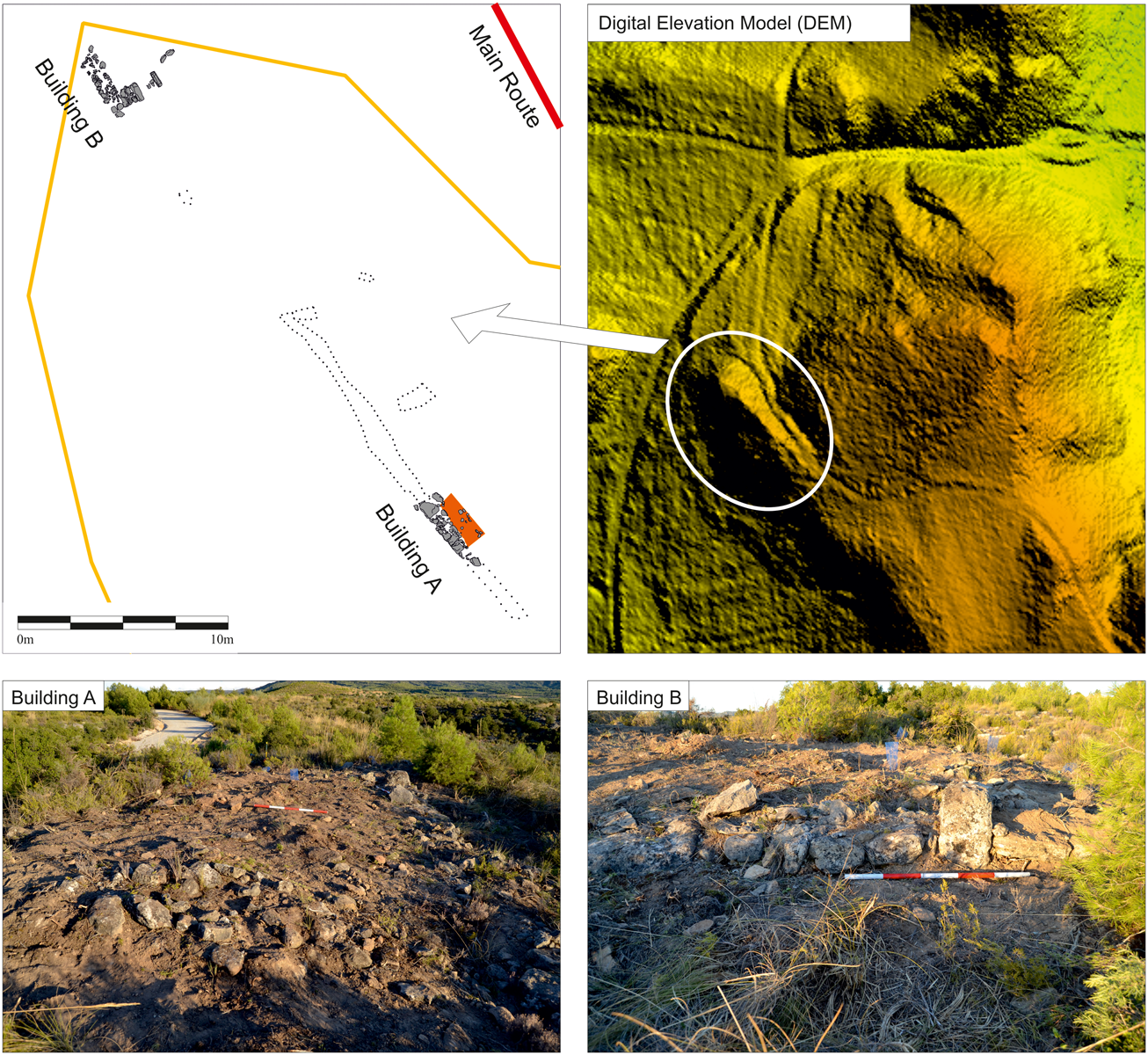
Fig. 5. Remains of the rectangular structures at La Paeriza, next to the potential aqueduct cascades. (Olmo Enciso, Castro Priego, Ruiz Zapata et al. Reference Olmo Enciso, Castro Priego, Ruiz Zapata, Gil García, Galindo Pellicena, Checa Herráiz, de la Torre-Verdejo, Gelichi and Corrò2019.)
In total, the aqueduct's course is calculated to be 5,090 m, with a drop in height of 73 m, which gives an overall gradient of 14.34 m/km. This figure would still give this aqueduct one of the steepest inclines in the Iberian Peninsula, almost tripling the 5 m/km gradient suggested by Vitruvius and far beyond the 0.208 m/km slope that Pliny proposes.Footnote 21 This average gradient, however, includes the possible cascades at La Paeriza. If the course is divided into three main sections separated by the cascades, the first section (which includes all the documented remains up to La Paeriza) has an average gradient of 16.5 m/km, the cascades would be 66.3 m/km, and the reconstructed course on the approach to Reccopolis, 2.59 m/km (Fig. 6).
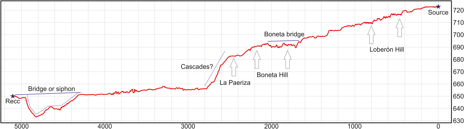
Fig. 6. Elevation profile of the aqueduct. (Image by the authors.)
Regarding its construction, the aqueduct was built like any comparable aqueduct of Roman date, underlining the resilience of the original Roman design, with solid, mortared foundations and a channel inside masonry walls. Rather than ashlar masonry or brick-faced concrete, the Reccopolis aqueduct employs two-faced, roughly hewn mortared rubble of local sandstone, the quarries for which have been identified near the aqueduct at Boneta Hill. The structure's width varies, but it ranges between 1.4 and 1.6 m. The specus itself is box-shaped, 0.5 m wide on average, and up to 0.25 m deep, framed by walls of mortared rubble and lined with opus signinum with very coarse ceramic aggregates. The cover of the conduit has not been preserved, but it was more likely sealed with flat slabs or tiles than with a running barrel vault.
The construction technique alone is enough to link the aqueduct with the city of Reccopolis, as it matches the techniques and materials used in the upper city. Moreover, the presence of ARS forms in the opus signinum further confirm the Late Antique chronology. All this proves in principle that the aqueduct was part of the city's first construction phase in the late 6th c.Footnote 22 But while the craftsmanship and technique show clear parallels with other constructions of Visigothic times, the overall design seems beyond the capabilities of local builders. This aqueduct is the first example of complex civil engineering in the Iberian Peninsula since the 4th c., and with no demand for specialized architects, it is doubtful that the apprenticeship chains that handed down this practical and technical knowledge would have been preserved throughout the 5th and 6th c. Considering also that Reccopolis was built after the campaigns against the Byzantine enclaves of the Mediterranean coast, it may be the case that the engineers who designed the aqueduct were brought in from elsewhere – probably the Roman East.Footnote 23
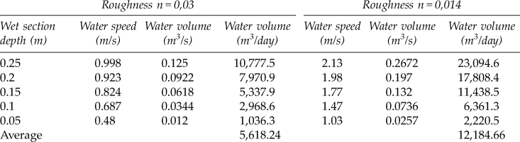
Considering the overall gradient and the average dimensions of the conduit, the aqueduct had a maximum capacity of up to 23,000 m3 of water per day (Table 1).Footnote 24 It is unlikely to have carried this volume on a regular basis, as in such a steep conduit, that volume of water would have accumulated a lot of momentum, damaging the aqueduct. Moreover, the two springs that flow into the Madre Vieja, located a kilometer to the southeast of the current remains in the village of Albalate, have a combined output of just over 10,000 m3/day,Footnote 25 and while it is possible that the aqueduct diverted the stream in its entirety, it is more likely that only part of its water was diverted and that the conduit had a lower average flow of 3–6,000 m3/day. This is in line with the flow discharge of other Iberian aqueducts, but still far less than the volume of water carried by the largest Roman conduits.Footnote 26 Lastly, the steep gradient of the conduit could generate high flow speeds (up to 2 m/s) but the average (between 0.5 and 1.5 m/s) is still sufficient to ensure that sediment flowed off the conduit without risking the integrity of the structure.Footnote 27
Table 1. Calculated volume of water carried by the Reccopolis aqueduct (using Manning's equation - see appendix)
For any estimate of the city's number of inhabitants based on the area within the walls and ancient population densities (Wallace-Hadrill suggests 150 p/ha for Pompeii, which would mean some 3,000 inhabitants for Reccopolis),Footnote 28 these volumes amount to hundreds of liters per capita per day. This raises the question of what all this water was used for in the Visigothic city.
Alternative sources
The excavations of Reccopolis are limited to the palace-basilica complex, the area around the commercial street, and part of the fortifications, so our knowledge of water supplies apart from the aqueduct is fairly limited. Even so, it appears that the aqueduct was a central element in the life of the settlement and in making Reccopolis a city.
Reccopolis was built by the River Tagus, which could have provided all the water the city needed. It was a generally accepted fact in antiquity that river water was not good for drinking, but the use of the river as a water source should not be discarded too quickly. It would have been a constant and reliable source of poor-quality water of the kind that could be useful for all activities other than drinking and cooking, like cleaning, bathing, or any industrial use. But the river's inconvenient location, at the foot of the hill, more than 50 m below, meant it would have been necessary to carry all river water uphill. While the river might have been a source of water for the suburbs (and the supposed river harbor), it was probably not of great use to the city proper – at least not while the aqueduct functioned.
For domestic purposes, Roman cities had always relied on springs, wells, and cisterns. In Reccopolis, however, we encounter none of these. Wells can be ruled out because all the negative features identified on site appear to have been silos, and none of them are deep enough. The water table, in any case, would have been dozens of meters down. As for springs, the database of the Spanish Geological and Mining Institute shows that there are none on the Reccopolis hill. We have no accurate data for the hydric regime of this region during the Visigothic period, but it is possible that there were springs near the city. The characteristic seasonality of the springs of the southern plateau of Iberia, however, makes them a less-than-ideal source of supply.
That leaves cisterns. Most ancient cities that relied on an integrated network of rainwater cisterns for their water supply had a combination of public and private facilities.Footnote 29 Excavations have shown two quadrangular structures that could be interpreted as cisterns, both with solid walls and a capacity of ca. 500 l, built in the first phases of the city (Fig. 7). One of them is located inside a house (area 16,000) and the other is attached to the corner of a rectangular building that separates a street (running east–west) from a square. The second of these could have been for public use (area 2,000). However, neither of these structures can be rainwater cisterns. The one located in the house (in area 16,000) is at the highest point of the courtyard. Since the house is built on a slope, it would be counterintuitive for it to be a rainwater collector. Furthermore, even if these houses had tiled roofs, their elongated layout minimizes the roofed area that could have collected rainwater, the possible courtyard is located in a central position (not even against the upper wall), and they have tiled drains flowing out into the street.Footnote 30 There is, however, a large, street-side structure in Reccopolis that most likely was a public water storage and distribution point. The excavators refer to this as a public “cistern,” but this identification is problematic. As we will discuss below, it is better to interpret this construction as a fountain.Footnote 31
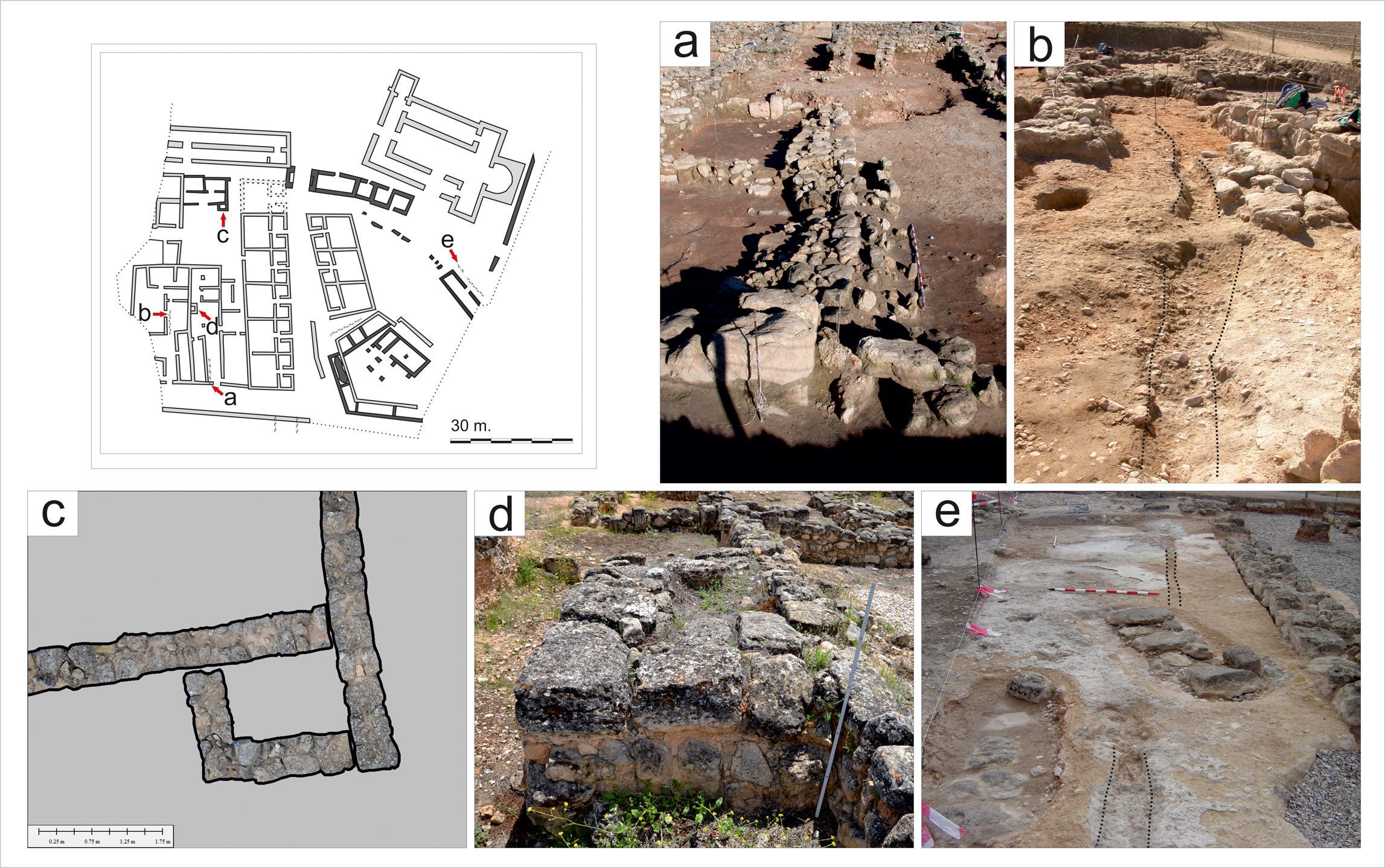
Fig. 7. Reccopolis cisterns and street drains: a) channel in house (16,000); b) channel in house (17,000); c) private cistern (16,000); d) public cistern (2,000); e) channel in street. (Image by the authors.)
Cities existed for centuries without aqueducts, relying on the wells-springs-cisterns triad of alternative water supplies. Even after aqueducts were introduced, they were never meant to substitute for the original supplies; aqueducts were meant to bring water in large quantities, providing a convenient and reliable source of water. This is a well-known model, evident across the Roman world. The limited evidence we have so far, however, seems to indicate that the Reccopolis aqueduct was a central element in the city's design and conception.
Water in the city
Much has been written about the many uses of water in the Roman and Late Antique world, especially in relation to aqueducts, which allowed a specific type of urban life characterized by large-scale consumption of water.Footnote 32 In Reccopolis, there is little positive evidence for ways in which water was used and consumed, but the presence of the aqueduct raises some questions about which urban amenities were linked to Roman-style water culture.
Water quality and distribution
First, it is worth underlining that the aqueduct carried basic drinking water. The importance placed on quality in ancient water supplies (especially aqueducts) is well known, above all from Vitruvius, Pliny, and Frontinus.Footnote 33 Rainwater was always preferred, closely followed by spring water, because both are colorless, tasteless, odorless, clear, fresh, and without visible particles.Footnote 34 In the Roman understanding of environmental medicine, running water from hills and mountains (as with the Reccopolis aqueduct) came next in quality, then wells and still water from cisterns.Footnote 35 From our modern perspective we could argue against the quality of drinking water from the Madre Vieja River, but in the understanding of the engineers and architects who built Reccopolis and its aqueduct, it was perfectly acceptable for urban consumption – and it could have been improved if necessary with standard Roman filtering and purification techniques like sieves and settling basins.
The availability of drinking water in large quantities from the aqueduct and the lack of other viable domestic alternatives strongly suggests that public fountains existed in Reccopolis. It is usually proposed that the aqueduct supplied the civic (“palace”) complex exclusively, while the lower town relied on cisterns.Footnote 36 A display fountain and a private bath could have been part of the palatial/administrative hub of the new city, but these structures could not have been the sole recipients of the aqueduct discharge. Even at a minimum flow, the aqueduct could have potentially flooded the 130 m-long north building of the palace complex to a depth of 1 m in a day. It is therefore more likely that the aqueduct was part of an overall integrated city-wide distribution system, aimed at the general population. In fact, since the aqueduct's natural approach into the city from the east coincides with the highest part of the Reccopolis hill, transporting water to the rest of the city through pipes was a plausible solution.
As mentioned above, the public water point is at the bottom end of the commercial street (already a busy social landmark), at the corner with the main east–west axis. It is a large, rectangular structure, 15 m long and 3 m wide, separated into two chambers (Fig. 8). The north room has a vat roughly 6 x 2 m, 1 m deep, and cut into the bedrock, while the south room, which opened onto the street, is paved with flagstones. This water feature was built during the early 7th c.Footnote 37
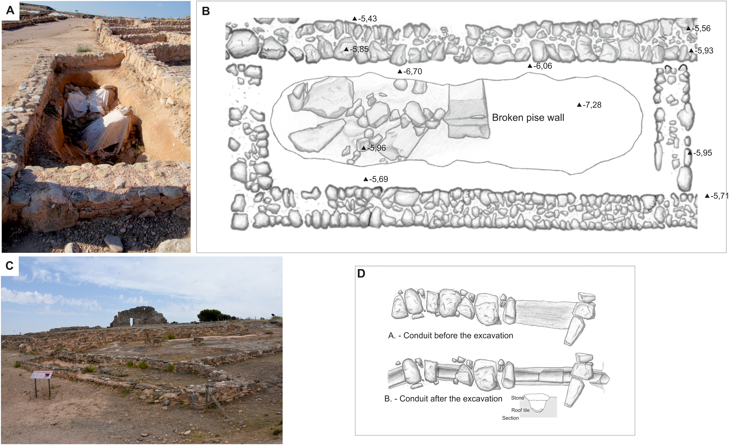
Fig. 8. The Reccopolis public fountain: A) view of the water basin; B) plan of the basin; C) view of the structure from the crossroads; D) covered water conduit excavated north of the fountain, possibly feeding into it. (Drawings B and C based on Olmo Enciso et al. Reference Olmo Enciso, Sanz Paratcha, López Fraile, Gómez García, Agustí García, Gómez de la Torre Verdejo and Esquinas Rodrigo2004.)
The excavators interpreted this structure as a cistern, and it forms the basis of their two-system water supply hypothesis.Footnote 38 However, it is difficult to understand how it could have functioned as a cistern. It is not directly surrounded by enough roofed surfaces to collect rainwater (the basin was itself roofed off) and if it relied on run-off water from other nearby roofed areas, there would be concerns about its quality and usefulness since the floors are not paved. The basin was enclosed on three sides but was accessible through the paved room, which would have been open to the street. This makes sense as a public water-collection point, and the flagstones would have kept the south room from turning into a quagmire with spillage, but it is not the best solution in terms of preserving the water; the vat would still have been partially exposed to the street and its contaminants. In other words, this type of open-air public basin only makes sense if it has a constant inflow of water that keeps it fresh; otherwise, it would have been nothing but a semi-protected pool of still water.Footnote 39 This structure must be understood as a fountain and not as a cistern. If the assumed date for the construction of the aqueduct is correct, then this water point would have been built at a later stage and not as part of the original design of the city. This does not rule out, however, that it was an integral part of the public water network connected to the pipe system.
The highest point of the Reccopolis hill, the potential location of the aqueduct's castellum, is no more than 100 m to the northeast of the fountain. It is conceivable that a pipe ran directly to it, either along the rear of the eastern workshops on the commercial street or on a longer route along the main street axes. As a hypothesis, it is possible that the structure identified as a stone-covered drain with a tiled bottom that runs under the dwelling structure wedged between the workshops and the fountain encased the (lead?) pipe that fed the fountain. The overflow from the basin would have run along the gap that still exists between the flagstones and the wall on the western side, before draining into the streets. This lacus-type fountain would be similar to those known from Pompeii and Ostia, a model that we know still existed in 6th-c. Lisbon and in the Late Antique East.Footnote 40 A recent study by a team from the University of Northumbria, which developed a way of calculating the inflow of a lacus-type fountain based on the size of the basin and the overflow outlet, has shown that water stayed in the Pompeian basins for less than three hours once they were full.Footnote 41 In Reccopolis, the basin is much larger than the Pompeian ones, with a capacity of some 12 m3, but the principle is the same. The public could have collected water either from the spout(s) or directly from the basin – both would have provided good-quality water for use in the neighborhood, and the water point would have served as a central focus of daily life.Footnote 42
The identification of this structure as a fountain has further implications for the patterns of water consumption in Reccopolis. Without ruling out private, piped supplies to elite houses (like those potentially identified in the geophysical survey of the upper terrace) or the presence of cisterns in unexcavated dwelling areas, the Reccopolis water network probably included, in the Roman way, other aqueduct-fed distribution points for the general use of the urban population.
Water use
The evidence for water consumption is limited. In the excavated areas of the city, there are a couple of structures that consumed water, but they cannot be directly linked to the aqueduct. Since they do not have any evident alternative supplies (like a cistern or a well), it is possible that they obtained their water from the river or a spring, although the presence of the aqueduct would suggest that they relied on the public supply. Out in the countryside, connections with the aqueduct are, on the other hand, more probable, although they are less clear.
In the city, we have evidence for water consumption in artisanal production. The commercial street of Reccopolis is flanked by glass workshops and goldsmiths.Footnote 43 Glass and gold working are not water-intensive productions like potteries or fullers, but like other industrial activities, they required a constant supply of water. Even if water was not necessary for the production process itself,Footnote 44 it was needed to clean and wash tools and materials, especially in contexts like Reccopolis, where the glass was being re-worked and recycled rather than produced from raw materials in situ.Footnote 45 These workshops did not have any direct water sources but made do with water stored in basins, which means that the craftspeople relied on the public supply for their workshops.
Next we have the baptistery, located at the north end of the basilica's narthex.Footnote 46 The baptisteries of this period consisted of small immersion pools,Footnote 47 but in the Reccopolis basilica we find, in contrast, a baptismal font.Footnote 48 Nevertheless, while water played a central role in baptism, baptisms during the Visigothic period happened only once a year, at Easter.Footnote 49 While workshops would have consumed water on a regular basis, the basilica was not a major water consumer, which further undermines the idea of the palace complex as the main beneficiary of the aqueduct. It is not unreasonable, however, to suggest that there was a bathing complex in that sector of the city that would have consumed large amounts of water.
In Late Antiquity, baths were still part of the ideal city. They were one of the elements that new settlers might have expected and would have been included in a new foundation.Footnote 50 Bathing in the Late Antique world had changed and evolved from the earlier, Roman imperial model due to a combination of financial limitations and Christian opposition to collective bathing, but public bathing still remained popular.Footnote 51 Moreover, public baths were still being used and built in 6th-c. Spain, as we know from Barcelona and Mérida.Footnote 52 In Mérida, we find smaller pools and individual tubs because the bath complex was no longer connected to the aqueduct system, even if it was built next to the theatre complex. The former bath complex, perhaps part of the episcopal enclosure, was fed by a pipe and was larger. Of course, Mérida was the most powerful city in Visigothic Spain, but Barcelona had become an important city as well.Footnote 53 Furthermore, we know of palatine baths in post-Roman Italy and, naturally, Constantinople.Footnote 54 Mérida and Barcelona had strong and wealthy elites who wanted to continue their urban bathing traditions, and Reccopolis, a royal foundation, would probably also have lived up to those expectations, regardless of its royal/palatine status. The upper city in Reccopolis was clearly the administrative hub and the area of elite residence. This area was conveniently close to the castellum, so it is where one would expect to find bathing complexes.
Another possible consumer of water is the supposed mosque, identified through geophysical survey.Footnote 55 Preliminary as this doubtful identification is, water plays a very important role in Islamic worship, for the ritual cleaning and ablutions required before prayers. Mosques do not require running water, but whenever this is available, water is piped to them. In Umayyad Spain, this system is best exemplified by the Great Mosque of Córdoba, whose fountains were fed by a diverted Roman aqueduct from the 10th c. onwards.Footnote 56 The supposed Reccopolis mosque is located on the lower terrace, so it could have potentially been linked to the pipe system were the conduit still in use.
Outside the city walls, the fact that the conduit diverted water for urban use does not preclude the possibility that the aqueduct was used for suburban irrigation, as has been proposed for Reccopolis.Footnote 57 Many other aqueducts intended for urban use had rural diversions (erogationes extra urbem),Footnote 58 but there is little evidence to substantiate such claims here. It is true that Visigothic legislation covered rural irrigation systems, and that some Roman irrigated fields continued in use during Late Antiquity, but in Reccopolis the only fields that could have been irrigated using water from the aqueduct were those in the immediate vicinity of the city, towards the east and south, past the cascades and La Paeriza. Up to that point, the terrain surrounding the aqueduct is too steep.Footnote 59 After La Paeriza, the plots seem to fan out from the high point, which may indicate a system of irrigation furrows. Normally, irrigated landscapes, even Roman ones with their furrow-systems, tend to remain irrigated, even to this day.Footnote 60 The fields around Reccopolis are not irrigated, although the national topographic map of 1935 shows they were covered in vines, which some ancient authors suggest were irrigated.Footnote 61 Irrigated fields around Reccopolis most probably exploited other waterways, including those fields established during the Islamic period and still irrigated today near where the Madre Vieja flows into the Tagus.
The sites of La Paeriza (fig. 5) and Loma Badujo, to conclude, may be two examples of rural use of the aqueduct. La Paeriza's connection with the aqueduct is clear, and Olmo's team has proposed that the settlement was a control point for the maintenance and running of the aqueduct, perhaps also working as a watering waystation.Footnote 62 However, it would not be completely out of the question that the structures were part of an (elaborate?) industrial complex similar to the Barbegal mills of Arles or the Late Antique flourmills of the Terrace House of Ephesus.Footnote 63 In Procopius's description of the siege of Rome during the Gothic Wars, the city is still supplied by aqueduct-powered mills,Footnote 64 so this is a technique that remained in use in the 6th c., and the location of La Paeriza has a sufficient gradient to have millraces. Loma Badujo, the second site, is located at a short distance from La Paeriza and was clearly an agriculturally oriented settlement. Because of its location, it is possible to suggest that it developed in direct relationship to aqueduct-irrigated fields.
Drainage
Even allowing for extra-mural water use, the aqueduct still brought hundreds of cubic meters of water a day into the walled area. This would have required an integrated and extensive network of drains to evacuate and channel out the aquae caducae, the used and excess water.
In all likelihood, the drainage system followed the pattern of the streets, as is the case in the rest of the ancient world. Moreover, the lack of domestic cisterns to collect rainwater, so far, and the city's tiled roofs would suggest that all rainwater ended up in the streets. One of the houses (area 16,000) that faces the main east–west axis has, indeed, a tiled drain that runs off the courtyard out to the street.Footnote 65 The walls of the unexcavated houses opposite 16,000 also have drain holes flowing out into the street. Remains of drainage channels have likewise been documented in other rooms of excavated houses.Footnote 66
Using the DEM and a simple hydrological flow accumulation algorithm, it is possible to generate a map that analyses drainage courses according to the terrain.Footnote 67 In this case, the main axis identified in the geophysical survey follows almost perfectly the path calculated by the GIS software up to the gate, confirming that this street was not only the main urban axis, but also the main wastewater collector for the upper terrace and the eastern part of the city (Fig. 9). It is also likely that the water flowed through the gate and out onto the hillside. It should be noted that after this exact point, the road follows a different path than that calculated for the drain, showing that outside the city walls, the street lost its role as drain axis. Surface finds, moreover, show large amounts of washed-out material in this area. At first, this suggested a potential location for the suburbs by the river, but it can now be interpreted as the point where the constant stream of wastewater washed out into the Tagus.
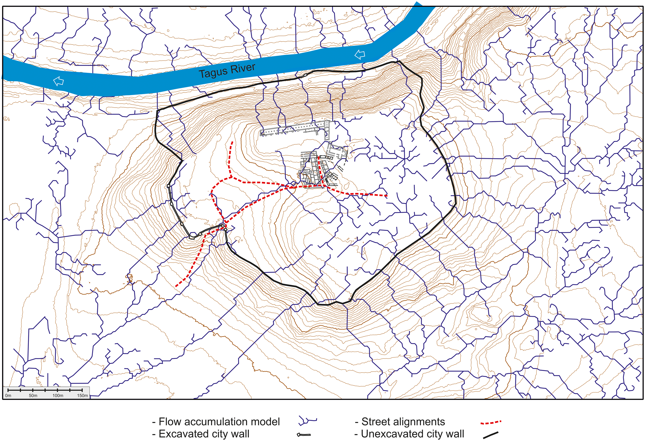
Fig. 9. Flow accumulation model (solid lines) with the identified street alignments (dashed lines) superimposed. (Image by the authors.)
The same flow accumulation algorithm suggests that the palace complex and the upper terrace would have drained directly towards the river down the north slope, and perhaps most of the aqueduct wastewater ended up flowing downhill that way. In that case, the wastewater must have been channeled to prevent hillside erosion – especially since under the palace, by the river, structures have been located during pedestrian surveys. Finally, it is possible that the drainage channel that can be seen heading towards the northeast represents the continuation of the main street axis and that others of these calculated channels mark the axes of streets in those areas that could not be geophysically surveyed, particularly east of the excavations.
The possibility that the city's drains were vaulted culverts under the street surfaces, in the Roman style, seems out of the question. Not only have none been found, but vaulting technology appears to have been lost by the Visigothic period,Footnote 68 and all new sewers that have been archaeologically dated to the 5th and 6th c. (Barcelona, Cartagena, Écija, Seville, Tarragona, and Valencia) seem to have been covered with flat lintels.Footnote 69 This flat-cover system would have made clearing blockages and clogs easier. Roman cities with underground sewers appear to have lost use of them due to lack of maintenance, except for those few examples like Córdoba, Mérida, or Zaragoza, where the sewers were large enough to be naturally flushed by rain water.Footnote 70
In Reccopolis there are two small masonry drains, covered with flat ashlars: one outside the basilica (Fig. 10) and another coming down from the eastern terrace towards the main street, mentioned above (and coinciding, moreover, with one of the flow accumulation channels calculated with the GIS software).Footnote 71 The reduced size of these conduits (20 cm wide) makes them perfect gutters for rainwater from individual buildings, and they may also perhaps be related to aqueduct overflow.
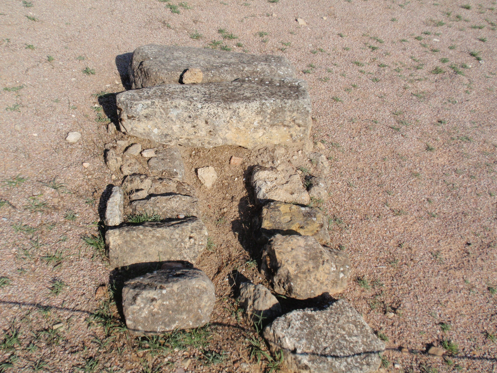
Fig. 10. Reccopolis masonry drain outside the basilica, flowing out into the open plaza. (Image by the authors.)
None of the streets, however, have covered drains; the commercial street, the excavated section of the main east–west avenue, and the east–west street south of the basilica all have concave profiles.Footnote 72 This suggests that the streets worked as open drains. This inversion in the concept of the street from convex, paved surfaces with underground sewers to concave, trampled, and metaled with central gutters is a pattern visible in various cities in Late Roman Hispania.Footnote 73 This solution is more complex in the commercial street because it runs on two levels, with the eastern half of the street separated from the western half by a step of mortared rubble. This left the street around the lacus at a higher, flatter level than elsewhere, turning the corner between the step and the lower street into a gutter that would collect roof water and any fountain overflow.
Masonry drains near built areas and street gutters are not mutually exclusive; the former could have carried water out of buildings into the latter. But because of the nature of this system, it is likely that these open-air street gutters were designed to evacuate rainwater and, potentially, fountain overflow. These were not drains for other forms of residue. Since cesspits have not been identified yet, it is probable that these residues were directly evacuated to outside the city rather than put out in the street, following a pattern which was firmly established by the Umayyad period.Footnote 74
Reccopolis and its aqueduct: a raison d’être?
The aqueduct of Reccopolis is a unicum for the West – much like Reccopolis itself. The construction underlines the reliance of the Visigoths on traditional Roman techniques (e.g., opus signinum) and the place of Reccopolis's aqueduct as one of the last examples of Roman hydraulic engineering. The conduit is ideally studied within our understanding of Roman urbanism; from that starting point, it is possible to interpret how the aqueduct could have been an integral part of the city and to recreate the water cycle from source to use and evacuation. But the meaning of the aqueduct for the city, for the Visigothic monarchy, and for its Late Antique audience needs to be explored further.
The aqueduct was, first, practical. Reccopolis was founded by a river in an area where permanent water springs abounded, but rather than being built somewhere where the inhabitants could take direct advantage of these sources, the city was established on a hill, far from the water table. It might have been easier or more convenient, water-wise, to build the city at a lower location, closer to the river, or even 4 km further east, on the secondary Roman road that runs through modern-day Albalate and Almonacid, which is where most of the springs are located.Footnote 75 These sites, however, have major defensive disadvantages, whereas Oliva Hill offered a wide enough perimeter to fortify and accommodate an urban area of some 16 ha. The fact that the Umayyad settlement of Zorita (built by the river, at a much lower level, and only a few hundred meters from a perennial spring) is still inhabited while Reccopolis is a ploughed field shows that Oliva Hill is, without an aqueduct, a less-than-ideal location for a settlement. The city was surrounded by sources of water, but the aqueduct was the only accessible and constant source of quality water, made available through public fountains and reservoirs. The presence of the glass-furnace workshops up in the walled city rather than closer to the river is easily explained if we consider the position of the crossroads fountain. The same applies to rectangular structures in house 16,000 and in the exterior of area 2,000, which may have been basins filled manually with aqueduct water or water brought from the river or the spring. The aqueduct also opens up the possibility of the existence of a bath complex, as would be expected at an urban foundation of this kind.
The aqueduct was, secondly, highly symbolic. In this aspect, it was very similar to the city walls. Celtiberia was not a frontier zone close to the Byzantine enclaves, nor do our sources mention this region as being particularly rebellious. Nevertheless, Reccopolis still had a wall, because such defenses were part of the ideal image of the city in Late Antiquity. Urban scenes in mosaics from Ravenna to Madaba depict cities as walled enclosures, much in the way Isidore describes the physical half of the city (urbs as opposed to civitas) as the moenia.Footnote 76 Walls were more than a marker of status; they were an integral part of the understanding of what a city was for its inhabitants, to the point that they were included in civic rituals that further reinforced this connection.Footnote 77 Reccopolis, in order to be an urbs, had to have walls. The same applies to aqueducts in Classical and Late Antiquity, and the admiration for these structures we see in Strabo and Frontinus is repeated in Cassiodorus.Footnote 78 Having piped water at a time when most aqueducts were going out of use due to neglect and disrepair added an element of prestige to a city, simply because it had something that others did not (or not any more). We see this, for instance, in the works of Theoderic, who was quick to rebuild the aqueduct of Ravenna, while also dutifully restoring the conduits of Rome itself.Footnote 79 We see it also in Procopius, who writes that Justinian was equally keen on repairing water conduits as part of his reconstruction and refortification effort.Footnote 80 Aqueducts had become a symbol of urbanization and power, both driving motivations behind the construction of Reccopolis in the first place, imitating Justiniana Prima and other Byzantine urban foundations.Footnote 81
Thirdly, and because of the two prior reasons, the aqueduct fulfilled an expectation. It was part of the Roman-inherited infrastructure that made a city in the minds of planners, the monarchy, and settlers.Footnote 82 Water supplies in new foundations are a must, of course. Most Roman cities were at first conceived with a combination of alternative supplies (wells, rivers, cisterns, springs), but after aqueduct construction became widespread in the Augustan period, long-distance conduits became part of the image of urban life.Footnote 83 Reccopolis was built with an aqueduct because an urban water culture had developed around Roman aqueducts for the past six centuries: having an aqueduct was what was expected of any new foundation that aimed to compete with the imperial cities.Footnote 84 This nuance is key, because aqueducts do not appear in other Visigothic foundations. El Tolmo de Minateda is the location of the Visigothic episcopal see of Eio/Elo, built near the Byzantine frontier in the 590s.Footnote 85 It is on a rocky outcrop that once housed a Roman settlement; wells are not an option there, and the settlement's frontier position made the construction of an aqueduct inadvisable, since aqueducts are key military objectives. Consequently, El Tolmo was supplied by a network of public and private cisterns that were part of the original design of the city, complemented by domestic storage vessels.Footnote 86 A similar example is Begastri, an old Roman settlement which was re-fortified as a frontier bishopric in the late 6th c.Footnote 87 In that case, we know for a fact that the old aqueduct, abandoned centuries earlier, was dismantled in order to recycle its stones for building material, while the new settlement relied on cisterns. In frontier settlements and fortifications, cisterns make ideal water sources, but there is something intrinsically different about Reccopolis and its aqueduct when compared with El Tolmo and Begastri. By creating new bishoprics, the Visigothic monarchy could legally claim the territories of those sees that belonged to cities under Byzantine jurisdiction.Footnote 88 These places could host garrisons and acted more like fortified outposts, even if they were civitates by virtue of being bishoprics.Footnote 89 But Reccopolis was meant to be an administrative city (a capital for Celtiberia) that would host a community of citizens. It was meant to replicate the ideal of urban life and to be display of royal power – hence the aqueduct.
A final caveat should perhaps be added here. This vision of the Late Antique city (a city without a grid or a theatre, but with walls and churches, a city with baths and, ideally, with an aqueduct) is an ideal. As with all such concepts, there is always a distance between the shadow we observe in the cave and the outside object that is illuminated. The vast majority of Late Antique cities had a Roman past that was modified by politics, time, abundance and lack of municipal funding, and changing urban habitus. Reccopolis did not aim to replicate that experience, but rather the abstraction that defined a city of its period. Focusing on the water supply, it is difficult to compare the Reccopolis aqueduct with others from Roman Spain – even those that were still in use in the 6th c. Technically they are very similar, as expected, but the way in which the Reccopolis aqueduct is integrated with its city's urbanism is quite different. Very few aqueducts continued in use by the time Reccopolis was founded. Only those of Valencia, Barcelona, Lisbon, Córdoba, and Segovia appear to have been still working, while those of Mérida, Seville, and Tarragona had probably been in use within living memory.Footnote 90 In some of these cities, as in Lisbon and perhaps in Barcelona, the aqueduct supply continued to be eminently public and aimed at the general population, but in other cases, like Valencia and Tarragona, local bishops appear to have been the main beneficiaries of this water.Footnote 91 In Italy, we know from the sources this was also an issue, but municipal institutions claimed back their public supplies.Footnote 92 A similar struggle could be envisaged for the Iberian Peninsula,Footnote 93 and it is not until late in the Umayyad period that we see a direct and complete privatization of public aqueducts.Footnote 94 In Reccopolis, the aqueduct supplied the upper city and the palace complex, but even still, the expectation, inherited from the Roman-period urban experience, was that such supplies were to be public. The corner fountain, the large volume of water carried by the conduit, and the lack of other domestic water supplies strongly suggest that the aqueduct served the city as a whole. The fact that El Tolmo had public cisterns as part of the city's design further supports this proposal that the monarchy was expected to provide water in its new foundations, while leaving all other urban aqueducts to their respective municipal authorities.
Conclusions
Reccopolis is an exceptional Late Antique foundation, with an even rarer Late Antique aqueduct. The conduit itself was built following all the Roman principles of aqueduct construction, from materials to design. With this in mind, it is possible to reconstruct a distribution network that followed Roman models, with a castellum at the city's highest point and a network of fountains fed by it – one of which has potentially now been identified. Other water-consuming structures, like display fountains and baths, are possible but remain to be found. To a degree, aqueducts and fountains were still common in the main cities of the Late Antique Mediterranean – even in the Iberian Peninsula – but they were growing increasingly scarce, which made Reccopolis's water supply system as much a display of power by the monarchy as the act of founding the city in the first place. The drainage system, however, reflects better the patterns visible in coeval cities, favoring concave streets and open-air gutters over underground sewers, more suitable, perhaps, for metaled (rather than paved) streets.
As a new urban foundation, Reccopolis represented the urban ideals and values of its time, not unlike the Victorian foundations in Canada and Australia, or the Spanish cities of the New World. In this sense, providing a public water supply for the general population appears to have been an essential part of creating a city, because beyond the practicalities and advantages of having an aqueduct, aqueducts had a more important symbolic meaning – one that linked Reccopolis to other imperial foundations in the Roman past and the Byzantine present. Of course, there were many alternative water sources around Reccopolis; the aqueduct was not a necessity for settlement or habitation of the hill, but it was a must if the new foundation was to be considered and understood as a city.
Appendix: water flow calculations
The volume of water flow (Q) has been calculated according to the following formula:
 $${\rm Q\ } = {\rm A\ } \times {\rm V}$$
A is the wetted area in square meters, given as the product of multiplying the width of the specus (b) by the depth of the water in the channel (h):
 $${\rm A\ } = {\rm b\ } \times {\rm h}$$
V is the speed of the flowing water in meters per second, which is calculated with Manning's equation:
 $${\rm V\ } = ( {1/{\rm n}} ) \times {\rm R}^{2/3} \times {\rm S}^{1/2}$$
where n is Manning's coefficient (which is itself dependent on the smoothness of the surface of the channel), S is the slope in a 1:1 ratio (i.e., m/m rather than m/km), and R is the hydraulic radius in meters, which is calculated by dividing the wetted area (A) by the wetted perimeter (P);
 $${\rm R\ } = {\rm A\ }/ \, {\rm P}$$
where  ${\rm P\ } = {\rm b\ } + 2{\rm h}$
For the case of Reccopolis, we have used the following parameters:Footnote 95
-
b = 0.5m
-
h = 0.25 to 0.05m in 0.05 m intervals
-
S = 14.34 m/km = 0.01434m/m
-
nmax (mortared rubble) = 0.03
-
nmin (plastered masonry) = 0.014
Acknowledgements
This paper was written as part of a María Zambrano postdoctoral contract with the NAHR (Nuevas Aproximaciones a la Hidráulica Romana) project, funded by European Union-NextGenerationEU through the Spanish Ministry for Universities. The original fieldwork was funded by the Oxford School of Archaeology through the Meyerstein Fund, by the Classics Faculty Craven Committee, and by Lincoln College, and it was included in the HAR-2009-11627 “Construcción y dinámicas del paisaje medieval” project, funded by the Spanish Ministry of Science and Innovation. Additional information has been obtained from excavation reports deposited at the Museum of Guadalajara. We must firstly thank L. Olmo for all his support throughout the years. We also wish to thank A. Wallace-Hadrill and B. Ward-Perkins for all their thoughts and ideas, J. Quinn for her insightful comments and corrections, and the editors and copyeditors for their fantastic work. Funds for Open Access publication provided by the University of Granada.
Competing interests
The author(s) declare none


 Open access