


Numerous investigations in the Muisca territory (Figure 1) distinguish three archaeological periods associated with ceramic assemblages: the Herrera period (about 400 BC–AD 1000), the Early Muisca period (about AD 1000–1200), and the Late Muisca period (about AD 1200–1600; Boada Rivas and Cardale de Schrimpff Reference Boada Rivas and de Schrimpff2017; Henderson and Ostler Reference Henderson and Ostler2005; Langebaek Reference Langebaek2001).Footnote 1 According to Langebaek (Reference Langebaek1995:152), during the Herrera period the population was small, and the settlement system consisted of separate, small aggregations with scattered dwellings located in the fertile valleys. The lack of sociopolitical integration does not allow the distinguishing of ruling elites, although some authors report differences in access to resources by the end of this period (Boada Reference Boada1999). The Early Muisca period is characterized by the occurrence of ceramic forms associated with festivities, the construction and use of ceremonial centers, and the most consistent evidence of goldwork and mummification. During the Late Muisca period there was a significant growth in population, an increase in the variety of ceramic forms associated with festivities, and development of a hierarchy of settlements, although there was some continuity in settlement patterns (Henderson Reference Henderson2014; Langebaek Reference Langebaek2001). According to Bernal (Reference Bernal2017:78), changes between the Early and Late Muisca periods defined by the ceramic chronology suggest transformations in demographic, political, and social features—centralization; the concentration of power, prestige, and authority in some individuals; differential degrees of control over economic resources; and the appearance of specialists—that are associated with an increase in social complexity.
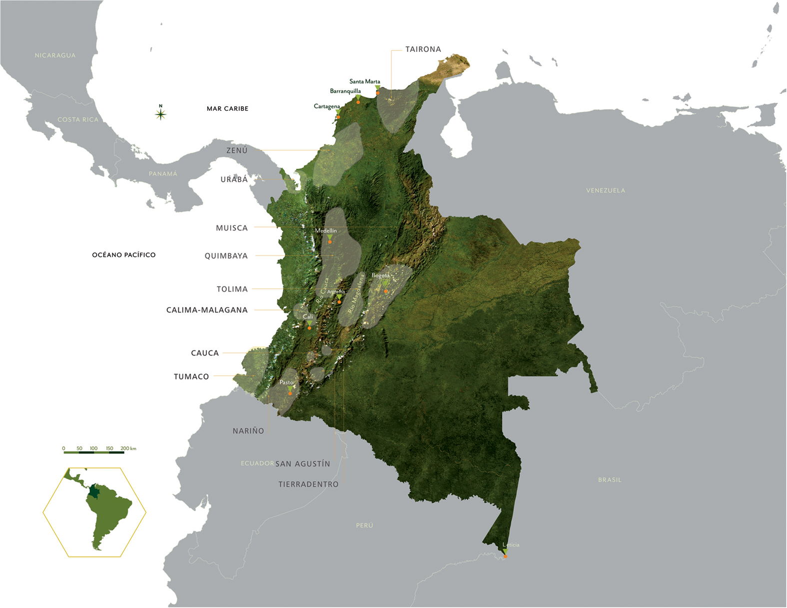
Figure 1. Archaeological areas of goldsmith societies in Colombia, with the Muisca territory indicated in the eastern mountain highlands (Museo del Oro, Banco de la República, Bogota). (Color online)
The Chiefdom of Guatavita at the Time of the Conquest
It is estimated that during the sixteenth century the Guatavita chiefdom was located in the southeast of the Muisca territory, east of the savanna of Bogotá. Some authors propose that it was a political unit of regional scope comprising local chiefdoms and captaincies located in the basins of these rivers: the Machetá River in the upper Tenza Valley, the Guavio River, and the Tominé River (Bernal Reference Bernal and Gamboa2008, Reference Bernal2017; Langebaek Reference Langebaek1987a; Perea Reference Perea1989; Pérez Reference Pérez1990).
Its location suggests that it could have been an uzacazgo (a chiefdom located in a border area to defend the Muisca territory), in which case it could have been subject to Bogotá. There is no evidence, however, that the cacique of Guatavita was an uzaque (a war leader) because nowhere does he appear with such an appellation. In some documents he is called a guecha (warrior; Perea Reference Perea1989:42). According to Pablo Fernando Pérez (Reference Pérez1990:3), the Guatavita territory was between the lands occupied by Zipa and Zaque, the two major chiefs in the Muisca region, but it was part of the “confederation” of Zipa, who was also the cacique of Bogotá. Pérez proposes that the caciques of Sesquilé, Suesca, Chocontá, Machetá, Gachancipá, Tocancipá, Cuenca, Teusacá, and Guasca were subject to the cacique of Guatavita.
The location of the chiefdom, in any case, seemed privileged because it had contact with the towns of the Tenza Valley, over which it probably exercised some type of control. This gave it access to different ecological niches that yielded a great variety of products (Bernal Reference Bernal and Gamboa2008, Reference Bernal2017; Langebaek Reference Langebaek1987b; Pérez Reference Pérez1990). According to Perea (Reference Perea1989), Guatavita was an independent chiefdom until shortly before the arrival of the Spaniards; it then became part of the confederation of Bogotá, the Zipazgo.
When the Spaniards arrived in the territory, there was no central organization for all the Muisca communities, nor were there supraregional entities, such as kingdoms or confederations (Bernal Reference Bernal2007). Bernal proposes instead that the plateau was occupied by a mosaic of independent chiefdoms of diverse structure and size, each of which was under the authority of a cacique whose territory was generally circumscribed to a valley. In Guatavita, however, the chiefdom's power could have spread over an entire region and encompassed several valleys. Moreover, within the Guatavita territory the Muiscas produced some essential goods, such as salt, coca, and cotton, which made it easier for political authorities to establish exchange networks with other localities and regions and, through these, strengthen alliances and loyalties (Bernal Reference Bernal2017:163).
The Spanish chronicles offer somewhat confusing narratives. According to Fray Pedro de Aguado, when Hernán Pérez de Quesada arrived in the savanna of Bogotá, probably around 1540, the cacique of Guatavita was subject to Zipa (Aguado Reference Aguado1906 [1581]:207). This is consistent with the version of Gonzalo Fernández de Oviedo y Valdés, who mentions that the cacique of Bogotá was the greatest of all the lords of that realm at that time (Fernández de Oviedo y Valdés Reference Fernández de Oviedo y Valdés1852 [1548]:359). Aguado insists that the cacique of Guatavita enjoyed a good reputation for having once been a competitor of the cacique of Bogotá. Juan de Castellanos summarizes this rivalry by narrating how Zipa Nemequene manages to defeat the cacique of Guatavita after bribing the Guasca cacique, who owed obedience to the Guatavita cacique (Castellanos Reference Castellanos1847 [1589]). The chronicle by Fray Pedro Simón (Reference Simón1891 [1627]:2:169) reinforces (or repeats) this story and adds that the cacique in the Guatavita province was one of the three great “dukes” of the Zipazgo of Bogotá, along with the caciques Ubaque and Suba.
Juan Rodríguez Freyle, on the contrary, describes the cacique of Guatavita as one of the two main heads of the “kingdom of the Muiscas,” the other being Ramiriquí in the jurisdiction of Tunja. According to Freyle, the cacique of Bogotá had the status of uzaque, and he lent his services to Guatavita's cacique. In this chronicle, the rivalry between the two chiefs arises when Bogotá's cacique defeats the rivals to Guatavita's power and gains great renown. Bogotá's cacique's own vassals then encourage him to fight the Guatavita cacique. His victory occurred between 1537 and 1538, around the time when the Spanish conquerors arrived (Rodríguez Freyle Reference Rodríguez Freyle1979 [1636–1638]:22–33). Lucas Fernández de Piedrahíta (Reference Fernández de Piedrahíta1688:30) later asserts that the supremacy of the cacique of Bogotá was assured from the year 1470, when Saguanmachica took the title of Zipa.
According to Carl Langebaek, Guatavita still retained its prestige during the sixteenth century because of two factors. First, it was a renowned goldsmithing center in the Muisca territory, to which Indigenous people traveled from all over the plateau to commission the elaboration of votive figures for offerings. Second, the domains of the chiefdom housed some of the most famous Indigenous sanctuaries, “especially in the various lakes of the hills that surround the Guatavita-Guasca valley” (Langebaek Reference Langebaek1987a:120). The lakes were considered by the Muiscas as a kind of temple, with Lake Guatavita being one of the most important (Casilimas and López Reference Casilimas and López1987).
Fray Pedro Simón (Reference Simón1891 [1627]:2:325) writes that “most of the guatavitas had excellence over the other Indians of the province [of Santafé] in melting and plowing gold.”Footnote 2 Alejandro Bernal (Reference Bernal and Gamboa2008:142–143) concludes,
If Guatavita was an important goldsmith center as some authors have postulated, then the objects elaborated in this chiefdom would have a greater symbolic power than those of other highland sites, a fact that would confer prestige to the cacique of Guatavita. Likewise, the manufacture of a certain type of ceremonial pottery, which was done in this chiefdom, and which is found in funerary contexts of several sites, both those mentioned and controlled by Guatavita and others close to the center and south of the plateau, would ratify the importance in religious terms.
Despite the difficulty of reaching a consensus on the political situation of the Guatavita chiefdom in the past, it is possible to see that, at least by the sixteenth century, the region enjoyed political and symbolic prestige.
Muisca Rituals
Although most of our knowledge on Muisca rituals comes from the Spanish chronicles of the sixteenth and seventeenth centuries, researchers have identified some aspects of the Muisca religious organization based on archaeological finds (Boada Reference Boada1989; Casilimas and López Reference Casilimas and López1987; Fajardo Reference Fajardo2009; Henderson Reference Henderson and Gamboa2008; Langebaek Reference Langebaek, Gnecco and Langebaek2006), archival documents (Casilimas Reference Casilimas2001; Casilimas and Londoño Reference Casilimas and Londoño2001; Londoño Reference Londoño1989, Reference Londoño1996, Reference Londoño2001), and ethnological analyses (Langebaek Reference Langebaek, Gnecco and Langebaek2006; Rozo Gauta Reference Rozo Gauta1997) and linguistics (González de Pérez Reference González de Pérez1996; Henderson Reference Henderson and Gamboa2008). Researchers (Correa Reference Correa2004; Lleras Reference Lleras2005; Rozo Gauta Reference Rozo Gauta1997) categorize Muisca ritual activities as rites of passage, political festivities, and religious celebrations, each of which had different purposes but shared two activities that seemed essential to their performance: the consumption of chicha and the making of offerings. This article explores the offerings made during the rituals.
Descriptions of the Muisca offerings vary because the votive activity is not restricted to a specific space or practice. The most commonly described objects correspond to the tunjos, a term coined in 1854 to refer to figurines found in the surroundings of Bogotá and that the Muiscas identified with the word chunso and the Spanish sometimes as santillos (Londoño Reference Londoño1989:107). The chronicles report that the offerings were made in places as diverse as lakes, rivers, caves, trees, precipices, waterfalls, terraces and agricultural fields, mountaintops and hills, dwellings, temples and sanctuaries, crossroads, near rocks, or, in the words of Lleras (Reference Lleras2005), “at any point where a jeque or a Muisca priest felt some special sign.”
The chronicles, however, do note the ritual specificity of votive practices. Fray Pedro Simón (Reference Simón1891 [1625]:3:198) observes that individuals had to consult a jeque, who indicated the steps to follow. The process began in a sanctuary and culminated with a collective ceremony that involved the relatives and the jeque. The celebration, during which they danced in a circle and drank chicha, is interpreted by Casilimas and López (Reference Casilimas and López1987:126) as a representation of the Sun, a supposition similar to that of Correa (Reference Correa2004). The required participation of a jeque in the deposition of votive objects noted by the chroniclers supports the categorization of offerings as being part of religious rituals.
Correa (Reference Correa2004:129) distinguishes a hierarchy between the priests and the tibas and jeques, associating them with shrines and individual sanctuaries, respectively; this supports the idea of a hierarchy of religious structure subject to politics. Correa (Reference Correa2004:103–104) suggests that “the collective ceremonies, although officiated by priests, were called by the cacique, which highlights their political meaning.” However, the existence of a religious structure did not support the existence of a caste that would monopolize religious affairs.
The word “shrines” that is frequently used in the chronicles refers to spaces for worship, which could be water sources or shrines built for particular or general rituals. Architectural constructions, however, were commonly referred to as sanctuaries or temples (Correa Reference Correa2004). Casilimas and López (Reference Casilimas and López1987) distinguish them as major and minor, as main and secondary. Londoño (Reference Londoño1996) also distinguishes two types: the bohíos (cucas) where the heirs to the chiefdom are confined, and the sanctuaries (shrines), small bohíos that contained idols to which offerings were made and that could also be called cucas (Casilimas and López Reference Casilimas and López1987; Londoño Reference Londoño1989:99). Espinoza and Gómez (Reference Espinoza and Gómez2000) suggest a more elaborate structure: major ceremonial centers and sanctuaries consecrated to sacrifices to the Sun, the investiture of caciques, and initiation rites situated near Lake Ubaque and Lake Guatavita; secondary major ceremonial centers near lakes, such as Fúquene, Tota, and the Quebrada de Baracio; minor ceremonial centers: enclosures; and private temples, the cucas near which the jeques lived.
El Dorado Ceremony in Lake Guatavita according to Spanish Chronicles
Of all the chronicles that describe Muisca rituals in Lake Guatavita, the best known is that of Juan Rodríguez Freyle about the investiture ritual for the successor of the chiefdom, known as the El Dorado ceremony. This excerpt presents the details of the ritual practice, helping us visualize the materiality behind the ceremony (Rodríguez Freyle Reference Rodríguez Freyle1979 [1636–1638]:17–18):
It was customary among these natives, that he who was to be the successor and heir of the lordship or cacicazgo of his uncle, whom he inherited, had to fast for six years in a cave they had dedicated and designated for this, and that during this time he had to take no part with women, nor did he eat meat, salt, or chili, and other things that were prohibited to him; and among them that during the fasting they could not see the sun; only at night were they allowed to leave the cave to see the moon and the stars and gather themselves before the sun saw them; and when this fasting and ceremonies were fulfilled, they entered into possession of the chiefdom or señorío, and on the first day they had to go to the great Lake Guatavita to offer and sacrifice to the demon, who they had for their god and lord. The ceremony that this involved was that in that lake a large raft of reeds was made, adorned and garnished all the showiest they could; they put in it four burning braziers in which of course, they burned a lot of moque, which is the incense of these natives, and turpentine with many other and various perfumes. At this time the whole lake was round, being very large and deep so that a high-board ship can sail on it; which is all crowned with an infinity of Indians, with a lot of feathers, gold jewels and crowns, with infinite fires around, and after the incense began to burn in the raft, they then lit it on land in such a way that the smoke impeded the light of day.
At this time, they stripped the heir in live flesh and anointed it with a sticky earth and sprinkled it with powdered and ground gold, in such a way that he was all covered with this metal. They put him in the raft, on which he was standing, and at his feet, they put a large pile of gold and emeralds to offer to their god. Four chiefs entered with him into the raft, the most important, his subjects well dressed in feathers, crowns of gold, bracelets and gold jewels and earrings, also naked and each one carried his offer. Once the raft departed from land, began the instruments, cornets, fotutos and other instruments, and with this a great gibberish that thundered mountains and valleys, and lasted until the raft reached the middle of the lagoon, where, with a flag, a signal for silence was made.
The golden Indian made his offer by throwing all the gold he had at his feet in the middle of the lake, and the other chiefs who escorted and accompanied him, did the same. Once finished, they lowered the flag, which was raised all the time that the offer had lasted, and leaving the raft ashore, the shout, bagpipes and fotutos began with very long riffs of cavorts and dances in their own way; with such ceremony they received the new elect by lord and prince. From this ceremony, they took the celebrated name of El Dorado, which has cost so many lives and farms.
It is from this chronicle that the ceremony held in the lake began to be associated with legitimation of the heir to the chiefdom of Guatavita. The chroniclers before Rodríguez Freyle describe it with almost the same words, but nowhere mention that it was the investiture ritual of the cacique of Guatavita (Castellanos Reference Castellanos1847 [1589]:453). By leaving some details out and adding new ones, Lucas Fernández de Piedrahíta made the stories of Castellanos and Simón fit with those of Alonso de Herrera and Rodríguez Freyle. After that, the idea that the ritual in Lake Guatavita was an investiture ceremony of the cacique was reproduced (Ramos Pérez Reference Ramos Pérez1987:296–304).
The chronicle of Fray Pedro Simón (Reference Simón1891 [1627]:2:242–243) relates that while Captain Sebastián de Belalcázar was in the city of San Francisco de Quito, he met a stranger who told him about a ritual in the region of the cacique of Bogotá: a naked cacique was covered with gold dust and made offerings of gold and emeralds in the middle of a lake. According to Simón, that is why Belalcázar and his men called the region the province of El Dorado; that is, where the golden man makes his sacrifices. The link between this and Lake Guatavita was not made until later (Simón Reference Simón1891 [1627]:2:248).
Simón writes that many roads reached Guatavita and that he and his fellow Spaniards witnessed the natives of these lands traveling to the lake and making offerings along the way. Once at the lake, the jeque would make offerings in the middle of the lake, on a raft together with the one interested in making the offering. Simón (Reference Simón1891 [1627]:2:247–249) reiterates that there were both minor offerings in the lake, such as those made by the jeques, and larger offerings, such as that of the cacique of Guatavita with the golden body. The descriptions of the El Dorado ceremony refer mainly to a votive ritual in the middle of the lake, with the participation of the “public” in noisy performances held around the lake.
The Spaniards describe other rituals in Lake Guatavita and in its surroundings. Londoño (Reference Londoño2001) reviews the chroniclers’ description of a great celebration, the Process of Ubaque of 1563, which the cacique of Ubaque required everyone to attend. It had several phases that involved vomiting, offerings, sacrifices, and the so-called correrías (apparently, a kind of procession). The purpose of these processions is not clear, but Rodríguez Freyle (Reference Rodríguez Freyle1979 [1636–1638]:36–38) describes a specific one, correr la tierra, which literally means “to run the land.” It began from various points and passed through five sacred lakes: Guasca, Siecha, Teusacá, Ubaque, and Guatavita, “the most sacred of all”:
In the last days of these festivities, and when the news that all the people had already run the land has been known, the caciques and captains and the main people of the great Lake Guatavita gathered, and for three days it all became a big drunkenness, a lot of moque and turpentine was burned, day and night, and the third day in very large rafts well adorned for this, with great music of gaitas, fotutos and rattles, and great fires and a crowd that was in contour of the lake, they reached the middle of it, where they made their offerings, and with that, the ceremony of running the land ended, returning all to their homes.
Simón claims that the fame of Lake Guatavita arose from the Muisca belief that, from time to time, a little dragon would rise up from its waters; the jeques would then wait for it in huts on the shore to make their offerings. The fame of the lake increased and, with it, the number of offerings after the wife of the most powerful chief of Guatavita drowned with her daughter and a maid because they wanted to escape from the punishments imposed for her adultery (Simón Reference Simón1891 [1627]:2:245–246). Simón also reports that the bodies of some chiefs were thrown into the lake along with all their riches. In addition, when the chiefs learned of the Spaniards’ arrival, many decided to offer their riches to the lake before leaving them in the hands of the conquerors; then, when the Spanish learned about these actions, they tried to drain the lake (Simón Reference Simón1891 [1627]:2:248).
Lake Guatavita
Lake Guatavita is in the southern part of the municipality of Sesquilé, where the eastern mountain range reaches its greatest width (Figure 2). The perimeter of the lake is approximately 400 × 300 m. The slopes of the land around the lake are inclined between 32° and 38°, and the highest peaks exceed 100 m asl. The highest part of the cone of the lake reaches 3,080 m asl, and its depth does not exceed 12 m (Espinoza and Gómez Reference Espinoza and Gómez2000:107). So far, the most convincing arguments about its formation suggest that it is a depression caused by underlying saline intrusions or strata (Espinoza and Gómez Reference Espinoza and Gómez2000; Guhl Reference Guhl1975).
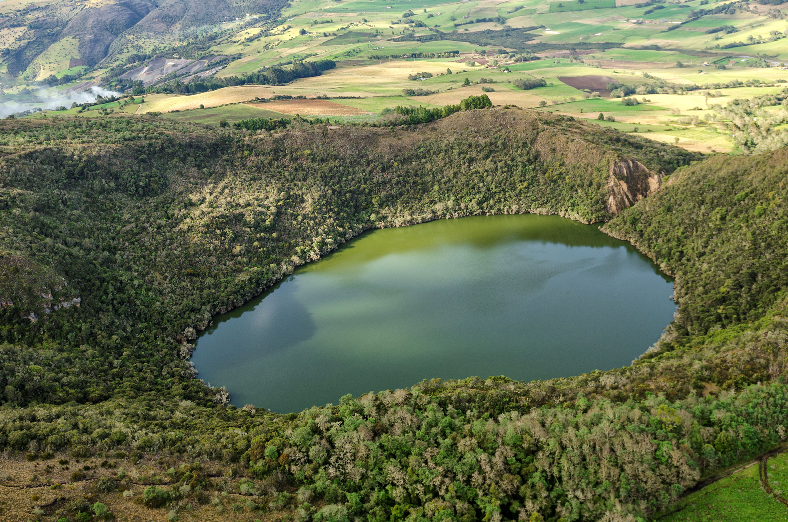
Figure 2. Lake Guatavita (photo by Juan Pablo Quintero Guzmán). (Color online)
The landscape of the lake has changed since the sixteenth century because of the numerous attempts to drain it, along with the lakes of Ubaque and Siecha. Liborio Zerda (Reference Zerda1883) writes that Hernán Pérez de Quesada and Captain Lázaro Fonte made the first attempt to recover the treasures of Lake Guatavita, with modest results. The intervention of Antonio de Sepúlveda in 1580, narrated by Fray Pedro Simón and by Juan Rodríguez Freyle, was more elaborate. They describe several houses next to the lake, a boat to probe the depth, and a large drain dug in the bank to empty the lake and then remove the offerngs from the lakebed. The drain left a large gap on the northeastern side of the lake, from which de Sepúlveda obtained great wealth. Apparently, a second attempt, in 1586, left Sepúlveda poor and tired and transformed the landscape again (Simón Reference Simón1891 [1627]:2:250).
The first scientific expeditions occurred years later, two of which stand out: the visit of Alexander von Humboldt in 1801 and the geo-cartographic survey of Agustín Codazzi in 1856 on behalf of the Comisión Corográfica: the latter survey was inspired by the stories of Codazzi's German predecessor, the historical investigations of Joaquín Acosta, and the collections of Manuel Vélez Barrientos. Francisco de Paula Santander, as well as English, Spanish and Colombian-English companies, continued to make efforts to drain the lake (see Espinoza and Gómez Reference Espinoza and Gómez2000:116–119). In a notarial document of 1820, the government's interest in recovering the treasures of the lake is evident, even though there is no evidence that those plans were ever executed. A fragment of this document reads as follows: “It should also be borne in mind that in the aforementioned lagoon there has been no attempt to find the famous Zipa treasure or any other large gold deposit. Historians and chroniclers only say that the Zipa bath took place there, and that many offerings were thrown at the party by the attendees. What has been found is enough to prove this tradition” (Posada Reference Posada1979:24).
In 1912, the British engineer Hartley Knowles celebrated his successful effort to drain the lake almost completely. According to an article published in the New York Times on October 27, 1912, large amounts of pottery, amber, gold, and precious stones were extracted in the process. Once the bottom was reached, the mud became concrete, and in the words of Knowles, “It took four years to drain the lake. Now we are excavating” (New York Times 1912). According to the article, the engineering company Contractors Limited bought the rights to exploit the lake from a small local company that would have tried the same feat without success between 1897 and 1900. In 1926, an article by Harold T. Wilkins in Popular Mechanics refers to the work of Knowles as one of the great engineering works to rescue “lost treasures.” This excerpt indicates the magnitude of the drainage work's impact on the landscape:
A tunnel was driven through seventy feet below the level of the surface. The water was drained off through carefully prepared sluices, and twenty-five feet of bottom mud was exposed after three years of boring and sluicing. Ornaments and jewels were found, but the mud set hard, and an attempt to drive the tunnel from the edge of the lake to the center was given up for lack of funds. Shafts were bored in the petrified mud, and channels driven through it. More gems were found, worth about $10,000. The treasure had sunk very deep down in four or five hundred years. Finally, the concern went into liquidation [Wilkins Reference Wilkins1926:424–425].
In 1932, groups of North American investigators probed the lake with heavy diving suits, and in 1965, a second expedition was halted by the Colombian government, which also succeeded in preventing the drainage of the lake by a British-Colombian company (Espinoza and Gómez Reference Espinoza and Gómez2000:116). During the second half of the twentieth century, the site was turned into a tourist center.
In 1997, the Corporación Autónoma Regional of Cundinamarca (CAR) decided to restrict entry to the area with the aim of recovering the native vegetation. In 2004, at the request of some members of the Sesquilé community and its mayor, it changed the name of the lake from Reserva Laguna de Guatavita to Reserva Forestal Protectora Productora Laguna del Cacique Guatavita y Cuchilla de Peña Blanca. The reserve covers more than 613 ha of the hill from Cuchilla Peña Negra, the natural limit of the valley on the eastern part of the sub-moor area that extends to the south up to Cerro Gordo and to the north up to Cuchilla Peña Blanca in the municipality of Sesquilé.
The lake opened several times for experimental tourism projects, but it was only in 2005 that it was officially reopened. The first phase of trail construction modified access to the lake with a pedestrian path that ascends along the western margin of the gap left by previous drainage efforts; it is 1,131 m in length and surrounds part of the lake. In 2006, while creating the pedestrian path, one of the CAR workers stumbled across with a vessel with four pieces of goldsmithing; it is now housed in the Museo Nacional of Colombia.
Materiality and Ritual Behavior in the Muisca Territory
There are few archaeological investigations of the ceremonial sites, and findings tend to be limited because of the relatively spontaneous nature of the Muisca ritual practices, particularly those related to offerings. One exception is the excavation made by John McBride in 1985 on the slopes of Cerro Majuy, Cota, Cundinamarca, in which he found large quantities of ceramic fragments from offering vessels and various tunjos, emeralds, stone blades, and necklace beads from the Sierra Nevada de Santa Marta. The site, which was dated to AD 1320, is where multiple votive rituals were performed that involved depositing the offerings, drinking chicha, and making ceremonial burns (Uribe et al. Reference Uribe, Londoño, Quintero, Martinón-Torres and Morales2013).
In recent decades, research has focused on studying the role of celebrations in power relations and as a factor in social change. Langebaek (Reference Langebaek, Gnecco and Langebaek2006) points out how interest in exploring the ideological aspects of power held by the Muisca caciques increased because of evidence that elites only played a limited role in the economic life of the community. These investigations tended to analyze the distribution of decorated materials as evidence of social differentiation and the distribution of artifacts related to the preparation, service, and consumption of chicha (jars, bowls, and cups) as catalysts for rituality. Boada (Reference Boada1989, Reference Boada2007), Kruschek (Reference Kruschek2003), Henderson and Ostler (Reference Henderson and Ostler2005), Henderson (Reference Henderson and Gamboa2008, Reference Henderson2014), Langebaek (Reference Langebaek, Gnecco and Langebaek2006), and Fajardo (Reference Fajardo2009) are important references.
The other focus for analyzing ritual activity in Muisca territory is the study of ceramic types. In the 1980s, Langebaek analyzed the dispersion of the ceramic type Guatavita Desgrasante Tiestos (GDT) and the relationship of its designs to ceremonial aspects and the role that Guatavita played in the Muisca territory. He observed that the ceramic remains of anthropomorphic offerings of GDT were frequently found in the summits of the hills that border the valleys of Guatavita-Guasca and much less so in the cold valleys and temperate lands. Langebaek (Reference Langebaek1987a) concluded that there was a close relationship between the ceremonial vessels of the GDT type and the consumption of narcotic drugs, divination rituals, and the making of offerings. Sylvia Broadbent, who in 1969 had suggested the importance of the GDT style before the conquest, later argued that it was used for ceremonial purposes along the plateau (Reference Broadbent1986). Tatiana Ome (Reference Ome2006) claimed that the GDT style (associated mainly with the Late Muisca period but also present in the colonial period) was used throughout the Muisca territory in ritual contexts and, to a lesser extent, in domestic contexts.
Archaeological Survey in Lake Guatavita: Methodological Aspects
To analyze the nature of the practices related to Lake Guatavita during the Muisca period, fieldwork was divided into two stages of data collection. The first was an extensive systematic survey with the objective of identifying the location of archaeological sites around the lake. The second stage consisted of an intensive systematic survey through the excavation of test pits in the identified areas. The surveys were recorded based on the aerial photograph of the Geographical Institute Agustín Codazzi (IGAC, c2800, No. 000135, scale 1: 39′750). The tests were performed based on a grid of arbitrary origin located toward the southwest of the prospected area and oriented with the magnetic pole.
Stage 1: Extensive Systematic Survey
The extensive systematic survey was carried out in an area of 147 ha covering the western side of the Reserva that extends, from south to north, from Cerro Gordo to Cuchilla Peña Blanca (Figure 3). On the eastern side, the limit included the slope of the mountain up to the boundary of the reserve: the landscape (the hill) was seen as a significant context of practices directly associated with the lake. The systematic survey was carried out in the area by means of surface collection units (3 × 3 m) or shovel tests of 40 × 40 × 40 cm located every 100 m. When the topography did not allow it, the collection was made at the discretion of the observer. In total, there were 136 collection spots (discounting the area of the body of water of 147 ha), of which eight were at the discretion of the observer. Of the totality of ceramic fragments collected, 76.6% were GDT, 10% were GDT Dragged, and 13.3% corresponded to the Ráquira type. The activities around the lake occurred mainly during the Late Muisca period.

Figure 3. Prospected area in the extensive systematic survey around Lake Guatavita, between the municipalities of Sesquilé and Guatavita.
The data collected in the surveyed area were classified and organized into contour maps based on the grid, thereby establishing the distribution and density of material culture areas. The areas for the intensive systematic survey were determined based on the contour map (Figure 4). Although the density of ceramic material in Site 1 was low, the distribution in space was not random, except for the few fragments found in isolation. The concentration of material on the north side of the lake (called Site 2) was evident.

Figure 4. Contour map with areas delimited in the sites for the intensive systematic survey.
Stage 2: Intensive Systematic Survey
The second stage was an intensive systematic exploration of Sites 1 and 2 to obtain data that would account for the activities carried out around the lake. Test pits were excavated (40 × 40 × 40 cm) every 5 m in these sites. In every case where material culture was recovered, it was at a maximum of 15 cm deep. In some areas, the first 5 cm was the vegetation layer resulting from the environmental recovery project that CAR has been carrying out for several years.
Site 1 was located approximately 500 m from the end of the slope that rises along the western side of the lake. Next to the site is a mound on which some of the fragments were found during the first survey. There was no funding to determine whether this structure was natural or artificial, and therefore it was left intact for future research. Two hundred test pits were created on Site 1 (Figure 5) with unexpected results: only a fragment of a thick and poorly cooked handle of the GDT type was found.
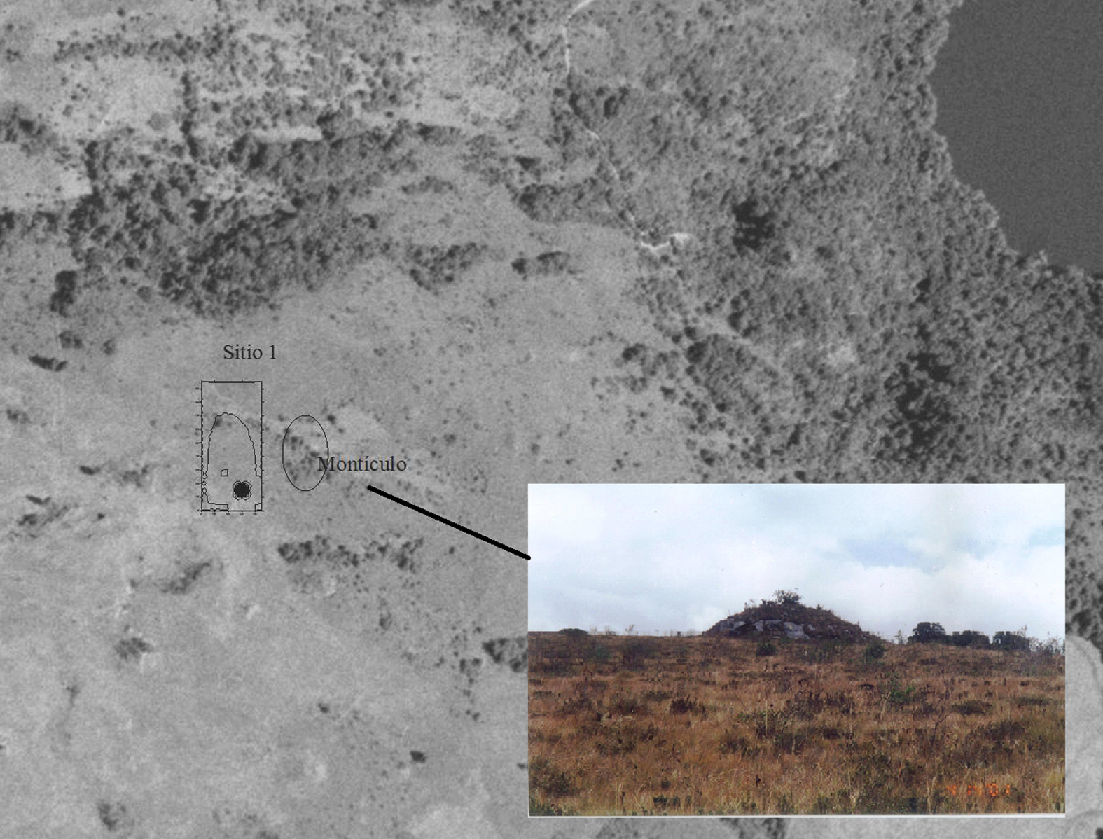
Figure 5. Delimitation of Site 1 and the mound (photo by Juan Pablo Quintero Guzmán).
Site 2 was located on the north side of the hill, with the lake on one side and the mountain on the other. At this site, 104 test pits were made along the edge, numbered from the lower left angle and oriented with the magnetic pole (Figure 6). A total of 157 ceramic fragments and a polished stone were recovered. The contour map revealed a high concentration of fragments in one test pit (#2–69) that were apparently from the same vessel. This outlier was removed from the contour map, thereby giving a clearer view of the density proportions at the site. In Site 2, 80.34% of the material corresponds to GDT ceramic type; 7.29% to Guatavita Desgrasante Gris (GDG); 7.29% to the Tunjuelo Laminar type; and 4.87% to the Guatavita Desgrasante Tiestos Dragged style. Almost all the diagnostic fragments belong to the GDT, GDG, and Tunjuelo Laminar types. Activities were concentrated between meters 40 and 100 and, to a lesser extent, between 0 and 20.

Figure 6. Contour map with the distribution of the material evidence found in Site 2.
Analysis of the Evidence
To determine the type of activities carried out in the sites identified around the lake, the material was divided into three categories: artifacts associated with the consumption of beverages and food (bowls and cups), artifacts associated with the preparation and service of beverages and food (jars), and artifacts associated with the making of offerings (offering vessels). The presence of fragments from these artifacts was taken as a parameter, since they denote the special nature of ritual activities (Falchetti Reference Falchetti1975; Langebaek Reference Langebaek1995), in contrast to what would be considered daily activities. The purpose is precisely to identify special, established activities that allow delimiting the material nature of the ritual in the lake. This follows the suggestion of Evangelos Kyriakidis (Reference Kyriakidis and Kyriakidis2007) that when archaeologists can trace performative activities and distinguish them from “normal” activities, they are ritual activities.
The data collected for Site 1 were not sufficient for an adequate archaeological analysis. There is even doubt as to whether it was an archaeological site. How to interpret the mound and the lack of evidence are discussed later.
In Site 2, there was a regular distribution of decorated material that is usually associated with special activities (Figure 7), and most fragments could be associated with certain forms according to the descriptions by Falchetti (Reference Falchetti1975), Langebaek (Reference Langebaek1987a), and Ome (Reference Ome2006). This facilitated the classification of the material.

Figure 7. Distribution and examples of decorated ceramic fragments. (Color online)
The forms associated with the GDT type in Site 2 are jars, bowls, cups, and offering vessels; the GDG style was found in cups and bowls; the Tunjuelo Laminar style was found in jars and bowls; and only bowls were in the GDT Dragged style. A total of 7.29% fragments of GDT and GDG could not be determined. It is noteworthy that the offering vessels were only of the GDT type. The highest proportion of fragments—44%—were offering vessels. It is generally understood that jars, because of their considerable size, were not used to transport liquids but to store them in some fixed place, most likely buried in the floor (Falchetti Reference Falchetti1975; Langebaek Reference Langebaek, Gnecco and Langebaek2006). The bowls and cups are understood as being used for serving and consuming food and drink, respectively, which is why it is common to find bowls associated with jars.
When the distribution of each form is analyzed in separate contour maps (Figure 8), offering vessels were mainly found between 80 and 100 m, whereas jars, bowls, and cups were distributed fairly evenly in the site. The distribution seems to indicate specific areas for each ritual activity involving serving and consuming chica and making offerings. In these maps, the outlier was included because not all the fragments associated with the offering vessels were found in the same test pit and those from the same pit (#2–69) were not all part of the same artifact. The largest proportion of jars were found up to 20 m from the offering vessels. Bowls were found more often in the same area as the votive offerings, whereas evidence of cups was found throughout the entire surveyed area.

Figure 8. Comparative distribution of jars, bowls, cups, and offering vessels on contour maps of Site 2.
Ceramic horizons allow us to infer that the activities around the lake were predominantly carried out during the Late Muisca period. Although the presence of Tunjuelo Laminar could suggest dates before the Late Muisca period and the presence of GDT Dragged and Ráquira (at least in the extensive survey) suggest dates around the contact period, there is very little evidence to support a continuity of ritual practices from the Early Muisca period until the colonial period. It seems more accurate to consider the continued use of certain types of ceramics during a specific period, in this case the Late Muisca, given that more than 95% of the material can be associated with it.
Discussion
I approach the evidence from two perspectives. First, the data from each site must be considered as an independent archaeological unit to identify the type of activities that each one represents. Second, examining the ritual nature of the landscape as an analytical unit requires an understanding of the social, political, and religious behavior patterns associated with Lake Guatavita.
Regarding the first approach, the discovery of very few fragments at the mound in Site 1 requires further investigation to determine the site's function. The mound's similarity to the structures described by Sylvia Broadbent in the Tominé Valley is striking. In 1963, she found some structures that she considered to be underground chambers covered with large rocks: “Inside, no cultural remains were found. The function of these structures is unknown: most likely they were tombs or sanctuaries, whose contents were stolen at the beginning of the colonial era. The few fragments of pottery found around the chambers suggest a date shortly before the European conquest” (Broadbent Reference Broadbent1969:22–23). According to Bernal (Reference Bernal2017:161), this type of structure was found only in the territory of influence of the cacique of Guatavita in the central-eastern sector of the plateau before the arrival of the Spaniards. The photographs taken by Bernal (Reference Bernal2017:204) show that they were composed of stone slabs that were inserted into the ground separately; they were not “box” tombs or dolmens. It is likely that the mound in Site 1 is one of these structures, probably funerary. In this case it would not necessarily be related to the activities carried out at Site 2, in which offering rituals were identified; in fact, such offerings are rarely associated with funerary assemblages.
The evidence from Site 2 clearly indicates that ritual activities were carried out there. It points to activities related not only to the consumption of chicha but also to its production, as well as to making offerings, which most likely became more standardized throughout the Late Muisca period; the evidence of chicha consumption is much greater than that of production. Although the amount of decorated material is less than that of nondecorated material, the high proportion of decorated diagnostic material indicates the display of ritual paraphernalia in activities related to the consumption of chicha and the deposition of votive offerings, which usually were performative events. The greater evidence of the consumption of chicha is important because it reinforces the ritual nature of making offerings (ritualizing them): it implies that they were not made at any random time, but that a series of formal and established activities institutionalized the practice. The consumption of chicha seems to involve communal activities, whether they were large-scale celebrations or small ceremonies involving a few drinkers. Thus, following the premise by Kyriakidis (Reference Kyriakidis and Kyriakidis2007), the activities in Site 2 were ritual activities. The question now is what kind of ritual.
Although evidence was found throughout an area of approximately 80 × 40 m, several factors suggest that the ritual activities were not of great magnitude. The low number of ceramic fragments and the limitation of the area to a relatively small space imply that these were not large-scale celebrations. The lack of differentiation in the dispersion and proportion of decorated fragments indicates that the activities were not economic in nature—involving tribute or competition by status or prestige. If they had been economic activities, there would be different proportions of decorated and undecorated material (Wells and Davis-Salazar Reference Wells and Davis-Salazar2004).
Considering the landscape as an analytical unit, how can the scarcity and limited dispersion of material evidence be understood, in contrast to the chroniclers’ descriptions of lavish rituals around the lake? How can we interpret the role played by these rituals in the sociopolitical structure of the Muiscas?
There are many debates about using ethnohistory in archaeological interpretations for the precontact past, yet the Spanish chronicles provide descriptions of specific rituals relating to offerings. From the archaeological perspective, however, relying on them is problematic given that the cognitive field—the semantic dispersion of the idea of the ritual—does not usually coincide with the material dispersion field. For example, the descriptions of the El Dorado and “running the earth” ceremonies imply that Lake Guatavita was a sacred part of the landscape among the Muiscas, but there is no archaeological evidence for that, at least in the perimeter of the lake.
Yet, even if the collective activities and the struggle for status usually involved the cacique or Muisca elites, the rituals in the lake did not necessarily serve only as a space for political legitimation. Ritual practices were not independent of power relations, but neither were they based entirely on the control of ideology during the Late Muisca period, at least around the lake, where the influence of the chiefdom of Guatavita was felt. The prestige associated with ritual control could be real but sometimes was limited, as Janet E. Levy (Reference Levy, Crumley, Ehrenrich and Levy1995:59) suggested, to what would be seen in traces of ritual occasions as ceremonies, feasts, or votive offerings.
Still, the cognitive dispersion field of Lake Guatavita might have extended past the hill, and so its fame could have provided prestige to the chiefdom to which it belonged, whereas the offering rituals were materially limited to part of the lake. Fray Pedro Simón, for example, describes how individuals who wanted to make offerings to the gods for any reason would go to the jeque, who would tell them what kind of offerings they should make. These religious specialists would officiate the ceremony alone in the sanctuary (Simón Reference Simón1891 [1627]:2:293–294). Fernández de Piedrahíta (Reference Fernández de Piedrahíta1688:21) also relates that people who wanted to ask for favors in temples had to do certain ceremonies that involved fasting and abstinence, but that “the gifts” should be given to a jeque who performed the offering ritual on behalf of the giver, who later celebrated at a party with relatives. Site 2 could be thought of as the context of a shrine in which a particular type of offering ritual was performed. Although it is difficult to determine how frequently the rituals were conducted, they were performed most likely seasonally or occasionally.
This frequency contrasts with the vast number of offerings found at the bottom of the lake for almost five centuries. What relationship could the rituals in Site 2 have with the offerings made directly to Lake Guatavita? Were they two different events? These questions are suggestive and invites us to think of specialized rituals in the making of offerings, which had their own paraphernalia and established procedures that differed from ceremonies or parties done in the lake itself. Future studies, such as iconographic ones, are needed to examine all the objects found in the lake that are now housed in museums around the world.
Final Thoughts, as Hypothesis
I do not conclude that an El Dorado ceremony never existed. The relationship between the description of the ritual in the middle of Lake Guatavita and the famous Muisca raft found in Pasca, Cundinamarca, in 1969—currently on display in Museo del Oro in Bogota—is almost undeniable. Why the raft was found in a cave in Pasca is another discussion (Uribe et al. Reference Uribe, Martinón-Torres, Quintero, McEwan and Hoopes2021). What is of interest here are the radiocarbon dates from both the raft and the litter that were part of the same votive context, which were recently published by Uribe and colleagues (Reference Uribe, Martinón-Torres, Quintero, McEwan and Hoopes2021:300): 600 ± 30 BP (Beta 410561) and 890 ± 30 BP (Beta 410562), respectively. The authors discuss in depth the chronological aspects of this votive context, so let me just offer some thoughts.
Around the thirteenth century, in the transition from the Early to the Late Muisca periods, there were changes in social organization that created sociopolitical tensions in the territory. During this time, one or several political leaders deployed power strategies that involved the celebration of rituals and the manufacture and deposition of votive objects. In this context, the El Dorado ceremony was celebrated in Lake Guatavita, and votive figures related to the power of some individuals, such as the raft and the litter, were made and offered throughout the territory so leaders could gain prestige among men and favors from the gods. Once the sociopolitical order stabilized, the offerings continued in sacred places, such as in Lake Guatavita, except that it was no longer the ceremony of the golden man. When the Spanish arrived, they encountered groups that had heard of the ceremony performed by their ancestors, and that is what they described to the conquistadors. The archaeological evidence found in this project is reminiscent of a series of ritual activities that are based on the El Dorado ceremony but were not the El Dorado ceremony.
Acknowledgments
I am indebted to the Corporación Autónoma Regional (CAR); to Jorge Cruz, who was in charge of the Reserva Forestal Protectora Productora Laguna del Cacique Guatavita y Cuchilla de Peña Blancal, and to the staff of the reserve, especially Javier, who provided me with logistical support. I must also thank the Museo del Oro and Sergio Roncallo, who provided support from the beginning of the project until the end of his life. This article is dedicated to Carlota, my daughter.
Funding Statement
The project had the Archaeological Research License #739 by Instituto Colombiano de antropología e Historia (ICANH) and was financed with the author's own resources.
Data Availability Statement
The data supporting the findings of this study are available within the article.
Competing Interests
The author declares none.


