


INTRODUCTION
The calcium carbonate skeletons of marine calcifiers such as foraminifera, bivalves, and corals contain a useful array of geochemical proxies that have been used to improve our understanding of past climate, ocean circulation, and atmospheric to surface ocean processes (Smith et al. Reference Smith, Buddemeier, Redalje and Houck1979; Beck et al. Reference Beck, Edwards, Ito, Taylor, Recy, Rougerie, Joannot and Henin1992; Gagan et al. Reference Gagan, Ayliffe, Hopley, Cali, Mortimer, Chappell, McCulloch and Head1998; Elderfield and Ganssen Reference Elderfield and Ganssen2000; Schöne et al. Reference Schöne, Freyre Castro, Fiebig, Houk, Oschmann and Kröncke2004; Lynch-Stieglitz Reference Lynch-Stieglitz2006). Coral carbonate reflects the Δ14C of surface seawater during the time and place of calcification because coral calcification uses dissolved inorganic carbon (DIC) from surrounding seawater, incorporating the radiogenic isotope 14C proportionally (Goreau Reference Goreau1977; Erez Reference Erez1978; Druffel and Suess Reference Druffel and Suess1983; Druffel Reference Druffel1987, Reference Druffel1997; Swart et al. Reference Swart, Leder, Szmant and Dodge1996; McConnaughey et al. Reference McConnaughey, Burdett, Whelan and Paull1997; Reynaud-Vaganay et al. Reference Reynaud-Vaganay, Gattuso, Cuif, Jaubert and Juillet-Leclerc1999).
Over the last 50 yr, the atmosphere and surface ocean ∆14C increased by nearly 100% and 20%, respectively, due to nuclear weapons testing in the late 1950s and early 1960s. 14C records in marine carbonates in surface waters lag those in the atmosphere, due to long equilibration times (~10 yr) and regional oceanographic features caused by the global thermohaline circulation, local upwelling, stratification, and freshwater impact (Southon et al. Reference Southon, Kashgarian, Fontugne, Metivier and Yim2002; Hua et al. Reference Hua, Woodroffe, Barbetti, Smithers and Zoppi2004). A single oceanographic measurement is therefore not representative of the entire global ocean (Guilderson et al. Reference Guilderson, Schrag, Kashgarian and Southon1998). The differences between ∆14C records of marine carbonates therefore allow the investigation of local and regional ocean circulation and thus can be used for testing and improving ocean circulation models (Reimer et al. Reference Reimer, Bard, Bayliss, Beck, Blackwell, Bronk Ramsey, Buck, Cheng, Edwards, Friedrich, Grootes, Guilderson, Haflidason, Hajdas, Hatté, Heaton, Hoffmann, Hogg, Hughen, Kaiser, Kromer, Manning, Niu, Reimer, Richards, Scott, Southon, Staff, Turney and van der Plicht2013), adjustment of fossil marine sample ages, and allowing for the investigation of oceanographic processes in specific regions.
This article presents a new Δ14C record, analyzed at annual resolution from a massive Porites lutea coral located at Hon Tre Island, Vietnam, in the South China Sea (SCS) to investigate the regional influence of atmospheric versus ocean circulation processes. We show the pre-bomb and post-bomb record from AD 1900–1986, and compare to six records around the SCS region. Our Hon Tre Island post-bomb 14C record shows values in between other coral records located in the SCS and Indonesian Seas and suggests influence of upwelled water from the Pacific North Equatorial Current (NEC).
OCEANOGRAPHIC SETTING
The SCS and surrounding region are marginal seas strongly influenced by the Asian monsoon, which is considered the most important factor for the formation and variation of the seasonal circulation (Hu et al. Reference Hu, Kawamura, Hong and Qi2000). The primary exchange with the Pacific Ocean is in the northeast, via the Luzon Strait. This strait has the deepest sill, ~1900 m, allowing the surface waters of the NEC to enter the SCS periodically via the Kuroshio Intrusion (KI) (Figure 1). In general, the summer monsoon begins in May and ends in September, with the winter monsoon period starting in November and ending in February. Summer monsoon winds flow weakly from the southwest towards the northeast and vice versa in winter, leading to anticyclonic and cyclonic basin circulation, respectively, in which water flows along the east coasts of Indo-China and the western Philippines following the direction of the monsoon winds (Xu et al. Reference Xu, Qiu and Chen1982; Fang et al. Reference Fang, Dwi, Indroyono, Quan’an, Qiao and Wei2005) (see Figure 1). The local bathymetry and stratification of the water column result in Ekman pumping and transport, which are important in the generation of summer upwelling offshore of the Vietnamese coast and of an offshore jet at ~12°N further from the coast (Kuo et al. Reference Kuo, Zheng and Ho2000; Dippner et al. Reference Dippner, Nguyen, Hein, Ohde and Loick2007; Hein Reference Hein2008; Chen et al. Reference Chen, Lai, Beardsley, Xu, Lin and Viet2012; Wang et al. Reference Wang, Wang, Li, Liu and Wu2013; Zhang 2014). In the southern SCS, surface water seasonally circulates via the Karimata Strait while some is transported through the Sibutu Passage, returning to the Indian Ocean through the Makassar Strait via the Indonesian Throughflow (ITF) (Gordon et al. Reference Gordon, Huber, Metzger, Susanto, Hurlburt and Adi2012).
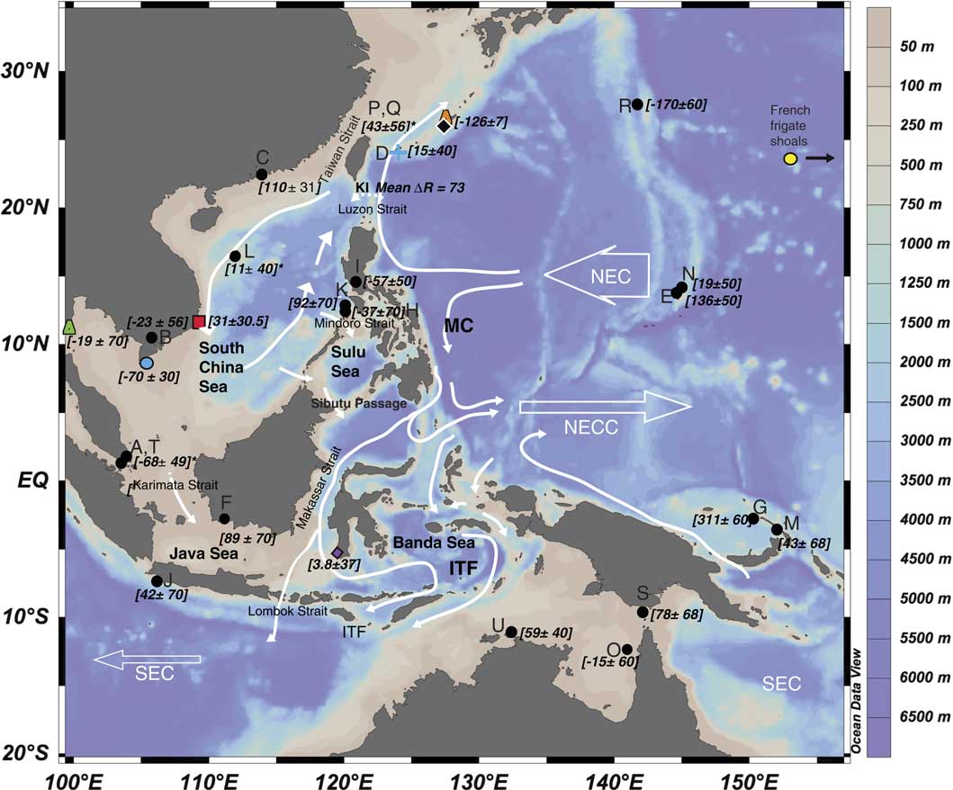
Figure 1 Bathymetric map (depth in meters on right axis) of the South China Sea and surrounding region. Mean annual circulation (white arrows) and marine reservoir corrections (black and colored symbols) are shown with errors where available (ΔR). The red square indicates this study’s data (year=1950) to closely match the data from Vietnam reported in Dang et al. (Reference Dang, Mitsuguchi, Kitagawa, Shibata and Kobayashi2004) (blue circle). Other symbols indicate location of studies used for comparison (see Figure 2). Black circles indicate the locations of ΔR values obtained from the marine reservoir correction database (http://calib.qub.ac.uk/marine/); see also Appendix 3. Asterisks indicate averaged records from the same location. NEC=North Equatorial Current; NECC=North Equatorial Counter Current; SEC=South Equatorial Current; ITF=Indonesian Throughflow; KI=Kuroshio Intrusion; MC=Mindoro Current. This figure was drawn using Ocean Data View (Schlitzer Reference Schlitzer2002).
MATERIAL AND METHODS
In March 2011, two Porites lutea corals were drilled from Hon Tre Island, Vietnam (12°12′49.90″N, 109°18′17.51″E). Hon Tre Island sits on a shallow ~100-m coastal shelf and the corals are located at the northeastern tip of the island. The two corals, To Nhat (TN) and Bai Bans (BB), were sampled using an underwater hydraulic drill, producing 4.6-m-long and 2.4-m-long cores, respectively. Each core was sectioned and then cleaned ultrasonically in deionized water, dried, and then X-rayed to reveal annual density bands. The Sr/Ca ratios from previous work confirm that darker bands (on an inverted X-ray) are formed during the winter and lighter bands during the summer (Bolton et al. Reference Bolton, Goodkin, Hughen, Ostermann, Vo and Phan2014). A diamond-tipped drill bit mounted on a Dremel® tool was used to drill annual bands from 1900 to 1986 from the longest coral (TN). In addition, one year (1969) was drilled at subannual resolution, by drilling parallel to growth axis in 1-mm increments to produce ~7 samples/yr. These subannually drilled bands were used to examine seasonal variability for that year. Subsamples of ~200 μg were analyzed for Sr/Ca by completely dissolving in 2 mL of 5% HNO3 and analyzing on an inductively coupled plasma optical emission spectrometer (ICP-OES) at the Marine Geochemistry Research Facility at Nanyang Technological University. Solution standards were used to correct for drift and matrix effects from varying Ca concentrations (Schrag Reference Schrag1999). The international coral standard JCp-1 was used as an internal standard, with a consensus Sr/Ca value of 0.01932±0.0002 ppm (Hathorne et al. Reference Hathorne, Gagnon, Felis, Adkins, Asami, Boer, Caillon, Case, Cobb, Douville, deMenocal, Eisenhauer, Garbe-Schönberg, Geibert, Goldstein, Hughen, Inoue, Kawahata, Kölling, Cornec, Linsley, McGregor, Montagna, Nurhati, Quinn, Raddatz, Rebaubier, Robinson, Sadekov, Sherrell, Sinclair, Tudhope, Wei, Wong, Wu and You2013). Our measurements of JCp-1 yielded an average value of 0.01932±0.000068 ppm (1σ) (relative standard deviation=0.36%, n=1620).
For 14C analysis, 7–8 mg of coral powder were acidified with 85% phosphoric acid to convert the aragonite to CO2 gas. The resultant CO2 was reduced to graphite on iron powder using the zinc reduction method (Xu et al. Reference Xu, Trumbore, Zheng, Southon, McDuffee, Luttgen and Liu2007). The graphite was then analyzed for 14C on an accelerator mass spectrometer (AMS) at the Keck Carbon Cycle AMS laboratory, using standard techniques (Southon et al. Reference Southon, Santos, Druffel-Rodriguez, Druffel, Trumbore, Xu, Ali and Mazon2004; Santos et al. Reference Santos, Moore, Southon, Griffin, Hinger and Zhang2007). Sample backgrounds were subtracted, based on measurements of 14C-free calcite. We report 14C measurements as age-corrected (or decay-corrected) Δ14C (Δ term of Stuiver and Polach Reference Stuiver and Polach1977). Total uncertainty of 2.4‰ was determined from the propagated error from averaged coral standards and duplicate samples measured. The data were not corrected for the Suess effect, the depletion of 14C from fossil fuel emissions (Suess Reference Suess1953).
MARINE RESERVOIR AGE AND CORRECTIONS
The 14C marine reservoir age (R) reflects the difference between the atmospheric modeled 14C age and the conventional 14C age of our coral samples, here expressed as the difference between the terrestrial calibration curve IntCal13 (Reimer et al. Reference Reimer, Bard, Bayliss, Beck, Blackwell, Bronk Ramsey, Buck, Cheng, Edwards, Friedrich, Grootes, Guilderson, Haflidason, Hajdas, Hatté, Heaton, Hoffmann, Hogg, Hughen, Kaiser, Kromer, Manning, Niu, Reimer, Richards, Scott, Southon, Staff, Turney and van der Plicht2013) and our coral 14C conventional age such that:
 $${\rm R}{\equals}^{{14}} {\rm C}_{{\rm coralage}} -^{{14}}\!{\rm C}_{{\rm INTCAL13age}} $$
where 14Ccoralage is the age of the coral sample and 14CINTCAL13age is the age as estimated by the IntCal13 model (Reimer et al. Reference Reimer, Bard, Bayliss, Beck, Blackwell, Bronk Ramsey, Buck, Cheng, Edwards, Friedrich, Grootes, Guilderson, Haflidason, Hajdas, Hatté, Heaton, Hoffmann, Hogg, Hughen, Kaiser, Kromer, Manning, Niu, Reimer, Richards, Scott, Southon, Staff, Turney and van der Plicht2013) for that same year. This value may also be different to the modeled R of the global surface oceans, e.g. Marine13 (Reimer et al. Reference Reimer, Bard, Bayliss, Beck, Blackwell, Bronk Ramsey, Buck, Cheng, Edwards, Friedrich, Grootes, Guilderson, Haflidason, Hajdas, Hatté, Heaton, Hoffmann, Hogg, Hughen, Kaiser, Kromer, Manning, Niu, Reimer, Richards, Scott, Southon, Staff, Turney and van der Plicht2013), which is expressed as the regional marine reservoir correction or ΔR (Stuiver and Braziunas Reference Stuiver and Braziunas1993) such that
 $$\rDelta {\rm R}{\equals}^{{14}} {\rm C}_{{\rm coralage}} -^{{14}} \!{\rm C}_{{\rm MARINE13age}} $$
where 14Ccoralage is the 14C age of the coral for any particular year and 14CMARINE13age is the 14C age as estimated by the Marine13 model (Reimer et al. Reference Reimer, Bard, Bayliss, Beck, Blackwell, Bronk Ramsey, Buck, Cheng, Edwards, Friedrich, Grootes, Guilderson, Haflidason, Hajdas, Hatté, Heaton, Hoffmann, Hogg, Hughen, Kaiser, Kromer, Manning, Niu, Reimer, Richards, Scott, Southon, Staff, Turney and van der Plicht2013) for that same year. The R and ΔR of our pre-bomb samples were compared to other corals in the SCS and surrounding region from previous studies.
RESULTS AND DISCUSSION
The Hon Tre Island pre-bomb (1900–1953) Δ14C and associated R and ΔR values are summarized in Appendix 1. The pre-bomb ∆14C values range from –60.8 to –48.8‰ with an overall decrease of –0.13‰/yr, as estimated using a linear least-squares regression. Because the ∆14C values are corrected for known age of formation, the decrease is assumed to be due to environmental changes including the Suess effect. Post-bomb annual (1954–1986) and seasonal (1969) Δ14C values are reported in Appendix 2. Between 1954 and 1986, the Hon Tre Island annual Δ14C has a range of 198.8‰, from a low of –43.6‰ in 1953 to a high of 155.3‰ in 1973 (n=29). The Δ14C values begin to rise in the early 1950s, and increase rapidly from 37.6‰ in 1962 to 74.5‰ in 1963 (Figure 2). Following the Δ14C high in 1973, which occurs approximately 10 yr after the 1963 atmospheric bomb peak (Nydal Reference Nydal2000), Δ14C values have been decreasing at a rate of ~1.1‰/yr. Using Equations 1 and 2, we calculated that our Hon Tre Island coral yields a R (from 1900 to 1950) of 342±19 yr and ΔR of 18±29 yr. The seasonal data in 1969 have a Δ14C range of 18±1.7‰ with the lowest values (138.4‰) occurring during spring and the highest (156.5‰) in the summer. The Sr/Ca maxima (SST minima) are 9.195 mmol/mol in late summer and 8.861 mmol/mol at the beginning of the year. The seasonal 14C trend therefore increases towards the summer with a coeval shift in Sr/Ca that reflects a change in SST from warmer to cooler temperatures (see Figure 2 inset).
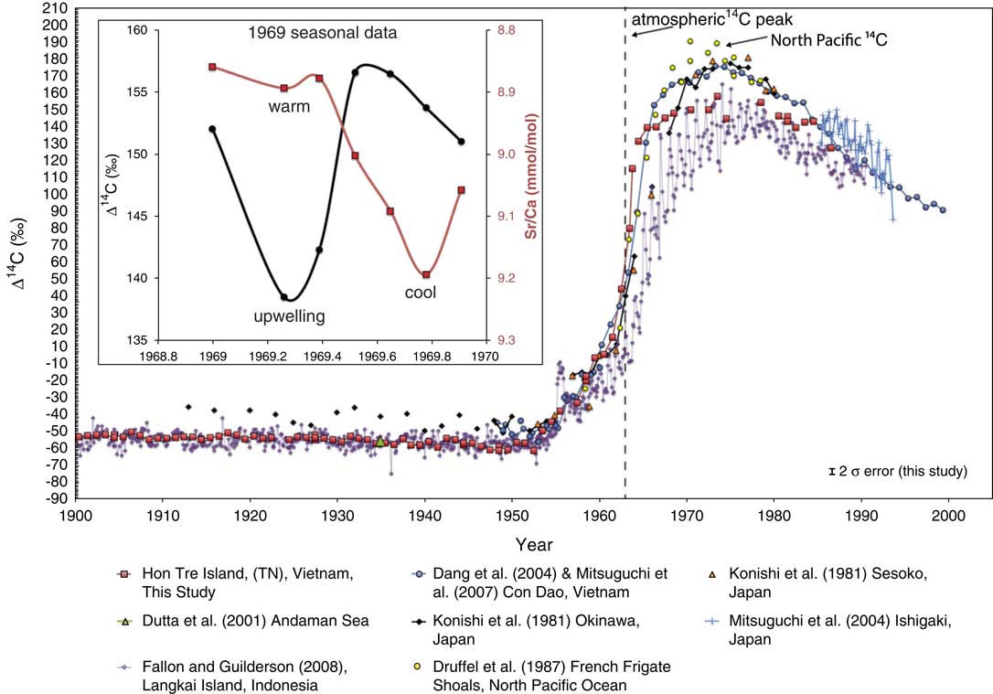
Figure 2 Annual coral Δ14C (‰) data from this study versus those of other SCS and tropical coral records from the Pacific and Indonesian Oceans. Inset: Seasonal Δ14C (black filled circles) and Sr/Ca (red filled squares) for 1969 to 1970.
Pre-Bomb 1900–1953
The SCS generally shows a distinct pre-bomb north to central/south variability in surface Δ14C owing, presumably, to the well-equilibrated source waters that enter from the western Pacific (Konishi et al. Reference Konishi, Tanaka and Sakanoue1981) (Figure 1). Pacific (NEC) water enters the SCS via the KI, which occurs when the Kuroshio Current flowing from the tropical Pacific north past Japan intrudes into the SCS (Wu et al. Reference Wu, Shaw and Chao1998; Chu et al. Reference Chu, Edmons and Fan1999; Xie et al. Reference Xie, Xie, Wang and Liu2003; Xue et al. Reference Xue, Chai, Pettigrew, Xu, Shi and Xu2004). The data in Figure 1 represent a compilation of pre-bomb ΔR values from other carbonate fossil material collected from the SCS and surrounding areas (see Appendix 3). The data show that the ∆R values within the central and southern SCS and those located south in the Indonesian Seas are equal (within 2σ). The R and the regional ΔR for the SCS are estimated to be 281±84 yr and −23±52 yr, respectively (Southon et al. Reference Southon, Kashgarian, Fontugne, Metivier and Yim2002; Dang et al. Reference Dang, Mitsuguchi, Kitagawa, Shibata and Kobayashi2004) and are within 2σ of the data from this study. Continuous pre-bomb records from the SCS and surrounding areas are scarce. However, Figure 2 shows available pre-bomb Δ14C from the Andaman Sea (–60.6±4‰, n=1, AD 1935) and Makassar Strait (Langkai Island, –55.0±3.5‰, n=467, AD 1900–1950), which share similar pre-bomb Δ14C values with Hon Tre Island (–54.3±1.9‰, n=57, AD 1900–1950). However, the annual trends in Δ14C are not consistent with this pattern. For example, there are some years when Δ14C in the Langkai Island (Makassar Strait) coral are higher (and vice versa) than our coral record. Some of this can be explained by the seasonality of the Langkai coral when compared to our annually resolved record; the former shows much higher variability. Both corals are also influenced by different monsoon systems. We discuss these in detail in the following sections.
Post-Bomb Period 1954 to 1986
Large differences appear when we compare the post-bomb Δ14C data from corals in the SCS and those from the surrounding bodies of water. During this increased input of anthropogenic 14C, there are distinct differences in each of the coral records. Around the bomb peak, corals from Japan (i.e. NEC waters) are consistently higher in Δ14C (up to 179‰ in 1977 at Sesoko), with North Pacific corals from the French Frigate Shoals showing even higher values that peak earlier (189‰ in 1970), whereas the Langkai Island coral’s highest value is 163‰ in 1974. Generally, these differences shown in Figure 2 agree well with the circulation of the SCS. Well-equilibrated water enters through the NEC via the KI, with the main throughflow moving surface water south along the Vietnam coast during the NE monsoon and flowing out through the Java Sea and into the ITF. In the Makassar Strait, the seasonal mixing of surface waters is complex but reflects the relative contribution of source waters from (1) the Indonesian Throughflow (ITF) originating from NEC and South Equatorial Current (SEC) surface and subsurface water, and (2) the South China Sea Throughflow, that enters the SCS from the Luzon Strait and exits it through the straits to the south (Qu et al. Reference Qu, Kim, Yaremchuk, Tozuka, Ishida and Yamagata2004, Reference Qu, Du and Sasaki2006). The relative contribution of these two source waters alternate during the SE and NW monsoon (Gordon et al. Reference Gordon, Huber, Metzger, Susanto, Hurlburt and Adi2012). Alternating mixing from tidal and Ekman pumping is extensive in the Indonesian Seas and changes the relative influence of NEC and SEC source waters that are transported through the Makassar Strait seasonally.
In the earlier part of the post-bomb Langkai Island record, a prominent but small peak in Δ14C is seen at around 1955, which was explained by Fallon and Guilderson (Reference Fallon and Guilderson2008) as resulting from nuclear fallout from early bomb testing in the Marshall Islands in 1953. It is likely, however, that this peak is not detected in other records due to the proximity of the sites (i.e. lack of direct fallout) and/or smoothing from annual sampling. The Hon Tre Island post-bomb values rise rapidly from 37.6‰ in 1962 to 74.5‰ in 1963 and peak at 155.3‰ in 1973 (Figure 2). The closest geographical Δ14C record to our site is from Con Dao Island in southern Vietnam. Δ14C at this location begins to increase sharply between 1963 and 1965 and reaches a peak of 173.8‰ in 1973. The relative difference in timing of these two records could be due (1) our site experiencing more rapid exchange of CO2 compared to the Con Dao record, overprinted by an upwelling signal, and/or (2) temporal changes in upwelling intensity, e.g. ENSO, that may also enhance or reduce gas exchange in particular years.
However, from 1966 onwards, the Con Dao Island record is consistently higher in Δ14C compared to our Vietnam record, almost matching the values in corals from Japan. Dang et al. (Reference Dang, Mitsuguchi, Kitagawa, Shibata and Kobayashi2004) and Mitsuguchi et al. (Reference Mitsuguchi, Dang, Kitagawa, Yoneda and Shibata2007, Reference Mitsuguchi, Dang, Kitagawa, Uchida and Shibata2008) have attributed this early rise and the enriched values to the shallow location of the coral on the Sunda shelf. Indeed, its location is isolated as it lies ~300 km from the deeper SCS basin. The possible mechanisms for lower ∆14C values at the Hon Tre Island coral site include (1) riverine input, (2) lateral advection, and (3) upwelling.
Freshwater rivers may contain lower ∆14C owing to the dissolved inorganic carbon (DIC) from ancient carbonates, known as the freshwater effect (Philippsen Reference Philippsen2013). We assume that riverine influence is negligible at our site due to the relatively small size of the nearest river (Cai) and the distance from this river to our coral site (~12 km). However, we cannot discount small amounts of riverine input during periods of extreme rainfall (e.g. during La Niña events). Depending on the monsoon season, lateral surface water advection could lower (or increase) coral Δ14C values as evinced by the pre-bomb north to central/south variability in surface Δ14C (Figure 1).
Intrusion of 14C-depleted water that reaches Hon Tre Island (but not Con Dao Island) must therefore originate from the south, as NEC/KI waters indicate higher ∆14C values (Konishi et al. Reference Konishi, Tanaka and Sakanoue1981; Mitsuguchi et al. Reference Mitsuguchi, Kitagawa, Matsumoto, Shibata, Yoneda, Kobayashi, Uchida and Ahagon2004). While northward flowing low-∆14C water could be present during the summer monsoon (Dale Reference Dale1956; Wyrtki Reference Wyrtki1961; Guilderson et al. Reference Guilderson, Fallon, Moore, Schrag and Charles2009), it cannot explain the higher Δ14C values found in the coral from Con Dao, which presumably would also be bathed in the same northward flowing water mass.
During the summer, there is a northeastward flow in the SCS and shallow coastal upwelling occurs at ~12°N (Xu et al. Reference Xu, Qiu and Chen1982; Shaw and Chao Reference Shaw and Chao1994; Chao et al. Reference Chao, Shaw and Wu1996; Xie et al. Reference Xie, Xie, Wang and Liu2003). This has been observed in numerous satellite, physical oceanographic, and model simulations (Pohlmann Reference Pohlmann1987; Kuo et al. Reference Kuo, Zheng and Ho2000; Dippner et al. Reference Dippner, Nguyen, Hein, Ohde and Loick2007; Barthel et al. Reference Barthel, Rosland and Thai2009). 14C measurements from intermediate and deep water in the SCS reported by Broecker et al. (Reference Broecker, Patzert, Toggweiler and Stuiver1986) are significantly lower, ranging from –106‰ at 420 m to –204‰ at 4170 m. The summer upwelling from Ekman transport is thought to be weak and limited to the upper 100 m of the water column (Dippner et al. Reference Dippner, Nguyen, Hein, Ohde and Loick2007; Barthel et al. Reference Barthel, Rosland and Thai2009). At the same time, wind stress is enhanced in the central SCS. The curl is positive in the northwestern SCS and negative in the southeast, with the strongest curl found off the coast of central Vietnam (Hein Reference Hein2008). Dynamical upwelling, from the clockwise rotation of the northward undercurrent or stretching deformation-induced upwelling from this general circulation pattern in the SCS is thought to result in stronger upwelling (Dippner et al. Reference Dippner, Nguyen, Hein, Ohde and Loick2007). This upwelled water is driven east and would therefore not reach the coral site at Con Dao Island.
The similarity of the post-bomb values in Langkai and the Hon Tre Island corals may initially suggest some connection between the upwelling rates and sources of the upwelled water (Figure 3). Both records have consistently lower Δ14C values compared to other corals located in the SCS with the Langkai Island coral having the lowest Δ14C values. The Langkai Island coral exhibits a clear seasonal signal with a range of 15 to 65‰ (Fallon and Guilderson Reference Fallon and Guilderson2008), whereas our seasonally resolved samples have a range of 18‰. This range is similar to coral Δ14C values at Ishigaki Island, which exhibits a seasonal range of 15 to 40‰ (Mitsuguchi et al. Reference Mitsuguchi, Kitagawa, Matsumoto, Shibata, Yoneda, Kobayashi, Uchida and Ahagon2004). The lowest Δ14C values at Langkai and Ishigaki Islands are observed during the boreal summer/austral winter (August) around the same time that upwelling can occur at our coral site. If upwelling is the main reason for our lower Δ14C values, then we also expect there to be similar seasonal variation, lowest during the boreal SW summer monsoon and highest during the boreal NE winter monsoon. Although we only have data for one subannually resolved year, the Δ14C values show a distinct range that suggests upwelling during this year is occurring in the spring, with Sr/Ca data indicating warm, but not maximum, sea surface temperatures. The Sr/Ca is the lowest towards late autumn, which matches a sharp rise in Δ14C that slowly decreases towards the winter. This observation in our record is intriguing and requires further investigation. However, prima facie, the seasonality observed in our record is similarly in phase with the Langkai and Ishigaki Islands seasonal cycle, although our SST proxy does not perfectly match up with the Δ14C, an observation also noted in the Ishigaki study. Mitsuguchi et al. (Reference Mitsuguchi, Kitagawa, Matsumoto, Shibata, Yoneda, Kobayashi, Uchida and Ahagon2004) hypothesized that the seasonality of their Δ14C values was related to the monsoon-induced local upwelling. Higher North Pacific ∆14C values are observed here, with the SSW-S monsoon during spring and summer inducing Ekman transport. The offshore transport of surface water leads to coastal upwelling of 14C-depleted subsurface water.
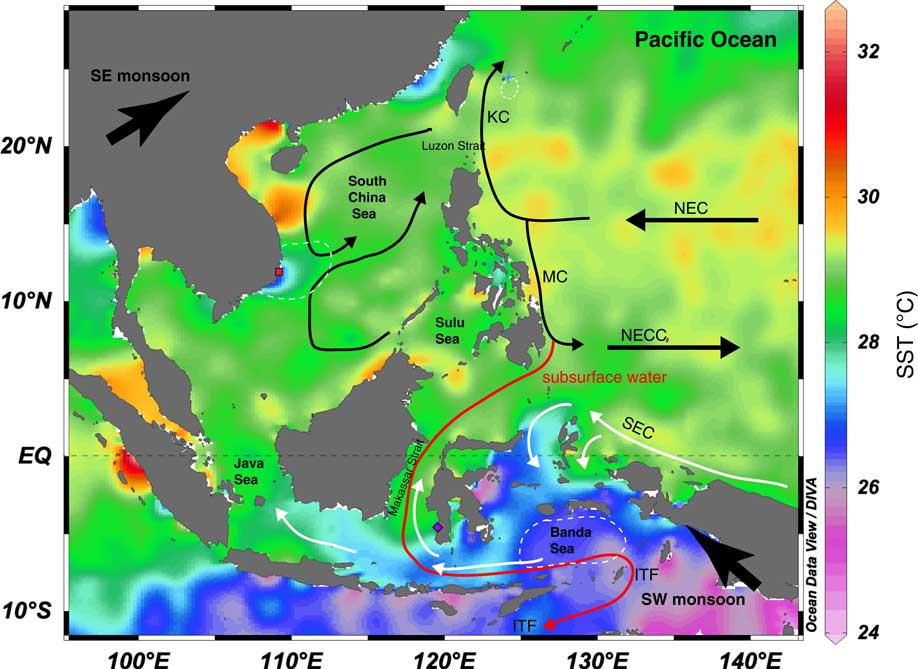
Figure 3 Ocean circulation and average sea surface temperature for August (1955–2012) in the South China Sea and adjacent seas. The red square indicates this study’s site, and the purple filled diamonds indicate the coral location of Fallon and Guilderson (Reference Fallon and Guilderson2008) at Langkai Island and the blue cross Ishigaki Island (Mitsuguchi et al. Reference Mitsuguchi, Kitagawa, Matsumoto, Shibata, Yoneda, Kobayashi, Uchida and Ahagon2004). Black arrows illustrate the main surface circulation of the SCS including the basin-scale cyclonic summer gyre (modified from Wang and Li Reference Wang and Li2009) and source waters from the Pacific Ocean (North Equatorial Current). White arrows indicate the surface ocean currents originating from the South Equatorial Current and red arrows indicate subsurface currents for the same months (modified from Fallon and Guilderson Reference Fallon and Guilderson2008). In general, during May-September, the monsoon winds in the Northern Hemisphere move from the southeast towards the northeast leading to anticyclonic basin-wide circulation in the northern half of the SCS. Ekman pumping and transport generate upwelling offshore of the Vietnamese coast (white dotted area) with the northeasterly flow diverting offshore at ~12°N further from the coast (Kuo et al. Reference Kuo, Zheng and Ho2000; Dippner et al. Reference Dippner, Nguyen, Hein, Ohde and Loick2007; Hein Reference Hein2008; Chen et al. Reference Chen, Lai, Beardsley, Xu, Lin and Viet2012; Wang et al. Reference Wang, Wang, Li, Liu and Wu2013; Zhang et al. Reference Zhang, Lan and Cui2014). During the same months in the Southern Hemisphere, in the region of the Indonesian Seas, the winds blow from the southwest towards the northeast. At the same time, the Banda Sea experiences intense vertical mixing, leading to lower surface seawater 14C content (Ffield and Gordon Reference Ffield and Gordon1996; Cresswell and Luick Reference Cresswell and Luick2001). NEC=North Equatorial Current; NECC=North Equatorial Counter Current; SEC=South Equatorial Current; ITF=Indonesian Throughflow; KC=Kuroshio Current; MC=Mindoro Current. This figure was drawn using Ocean Data View (Schlitzer Reference Schlitzer2002) using SST data from the World Ocean Atlas 2013 (Locarnini et al. Reference Locarnini, Mishonov, Antonov, Boyer, Garcia, Baranov, Zweng, Paver, Reagan, Johnson, Hamilton and Seidov2013).
Fallon and Guilderson (Reference Fallon and Guilderson2008) attributed the lower Δ14C values at Langkai Island to extensive upwelling occurring in the Banda Sea (East Indonesian Seas). The Banda Sea water has inputs from the South Pacific Equatorial Water, which is lower in Δ14C than that of NEC water. This would explain the overall lower Δ14C values compared to Hon Tre Island record. Although more data are required, our post-bomb Δ14C record also hints at seasonal input of upwelled water. This upwelled water appears to be a consistent feature that mixes significantly low ∆14C water from below the mixed layer with the surface waters in the region of Hon Tre Island. The source of this upwelled water is from the deeper SCS basin that originates from intermediate water fed from the Pacific via the Luzon Strait. The same NEC waters also influence the corals in the Makassar Strait and off the southern Sumatran coast, but consist of a mixture of both NEC and SEC water, the latter of which is more depleted in 14C.
CONCLUSIONS
We present a new annual Δ14C record for the years 1900 to 1986 and one subannual record of Δ14C and Sr/Ca (1969), from Hon Tre Island, Vietnam, extending the southern SCS Δ14C record. Our pre-bomb coral Δ14C record, along with other pre-bomb records from the southern part of the SCS, show a low marine reservoir effect, and are significantly lower than those from Japan. Following the input of bomb 14C, our coral showed Δ14C values that lie in between those from corals bathed in NEC waters and those in the path of the ITF in the Makassar Strait. The data suggest that upwelling at both sites is controlled by different mechanisms under a boreal summer monsoon regime—the combination of Ekman transport and the basin-wide gyre system in the SCS affect upwelling rates at Hon Tre Island—whereas the strength of the Southern Hemisphere SE monsoon affects upwelling rates in the Banda Sea and subsequent advection of water in corals in the ITF. The Langkai coral record represents the relative mixing rates between NEC and SEC intermediate source waters entering the Indonesian Seas; the lower Δ14C values in the Langkai record reflect more seasonal influence of modified, upwelled NEC and SEC water. Our Hon Tre Island record represents only seasonal NEC sourced intermediate SCS waters that enter through the Luzon Strait and are periodically upwelled at our study site.
ACKNOWLEDGMENTS
We thank two anonymous reviewers for their helpful comments. We also thank to K Hughen and J Ossolinski from Woods Hole Oceanographic Institution and the Nha Trang Institute of Oceanography for assistance with coral identification and collection. We also thank Ng Sin-Hwee for her assistance in subsampling the coral. This study was funded by the National Research Foundation Singapore under its Singapore NRF Fellowship scheme awarded to N F Goodkin (National Research Fellow Award No. NRF-RF2012-03), as administered by the Earth Observatory of Singapore and the Singapore Ministry of Education under the Research Centres of Excellence initiative.
APPENDICES
Appendix 1 Annual pre-bomb Δ14C (1900–1953) and calculated marine reservoir age (R) and marine reservoir correction (ΔR) from Hon Tre Island, Vietnam.

Appendix 2 Annual post-bomb Δ14C (1954–1986) and seasonal (1969) Δ14C and Sr/Ca ratios, Hon Tre Island, Vietnam.

Appendix 3 Compilation of 14C ages from marine carbonates samples from the SCS and surrounding regions. Data obtained from the Marine Reservoir Correction database (see http://calib.qub.ac.uk/marine/).


 Open access