


Introduction
In the wake of World War II, Poland acquired Silesia, Lubusz Land, Eastern Pomerania and southern East Prussia from Germany as ‘compensation’ for the lands in the east lost to the Soviet Union. The newly acquired territories (collectively called the ‘Western and Northern Territories’, or also the ‘Recovered Territories’) encompassed dozens of towns and cities, many of which were heavily damaged during the war. In fact, with the exception of Warsaw, they were much more devastated than the cities in the ‘core’ of Poland.Footnote 1 Thus, the Polish authorities faced the challenges of post-war reconstruction while attempting to make those towns and cities seem Polish and reshaping them into so-called socialist cities.
To legitimize the reshaping of the state borders and the new regime itself both internally and externally, the communist regime in Warsaw tried to link itself with the Polish state(s) in the early medieval period. The territories acquired in 1945 were therefore not ‘annexed’ but ‘recovered’. Depending on the location, the lands might not have been under Polish (or more generally Slavic) rule for hundreds of years, but that did not derail the narrative of ‘regaining’ the ‘true’ Polish territory – its ‘natural’ borders.
On the ground, this polonization of the landscape was brought about by choosing appropriate place and street names, establishing monuments for Polish national heroes, and so forth. The reconstruction of the heavily damaged cities and towns offered an opportunity to reshape their image by replacing ‘German’ architecture with a ‘Polish’ one. However, the process of recovering the ‘Polish’ past went even deeper and influenced the plans for post-war reconstruction. Using an example of the town of Racibórz in Silesia, this article discusses how concerns for ‘Polish’ history and socialist urbanism influenced post-war recovery in the ‘Recovered Territories’.
Article’s scope
This article examines the role of history in the planning process of a mid-size city in Eastern Europe in the aftermath of World War II, using the example of Racibórz. In particular, it probes the relative importance of the past in post-war recovery. In this way, it contributes to the academic debate on socialist cities by focusing on a smaller city, which was neither a model town nor a capital city. Such places are under-represented in the literature on the topic. This article also examines the national component of socialist classicism in terms of urban planning, rather than architecture, which is the typical angle from which this issue is analysed. Moreover, by focusing on planning post-war reconstruction, it deepens the understanding between those two urban categories. The time frame of this article (i.e. 1945–57) is dictated by the focus on socialist classicism, which in Poland ended soon after de-Stalinization was launched in 1956. Because urban planning lies at the centre, the architectural form is mentioned only briefly insofar as it is necessary to understand the issue at the core of this project.
Literature
The existing academic literature on the architecture and urban morphology of Racibórz focused heavily on the medieval period.Footnote 2 Less attention has been paid to other periods, although post-war reconstruction has not entirely escaped historians’ attention, with the emphasis decidedly on architecture, rather than urban planning. The reconstruction of Racibórz was guided by the preservation of the historical character of the city centre, but also by the introduction of greenery, and car-oriented development of the street network.Footnote 3 Already in the 1960s, there were initial descriptions of the process that were particularly critical of the policy of historicizing architecture in the early 1950s.Footnote 4 This is also observable in more recent scholarship.Footnote 5 However, no detailed and holistic scholarly analysis of post-war plans has been conducted.
The emphasis on the use of historizing architecture as a method of polonizing the cityscapes of former German cities is not limited to Racibórz by any means. For instance, Szczepańska demonstrated how Opole was rebuilt in a neo-baroque fashion to make it look more Polish despite the very thin historicity of such an approach.Footnote 6 Similarly, Wrocław was rebuilt with an emphasis on Gothic architecture as a tool for highlighting Polish claims to the city.Footnote 7 Szczecin was made into a Polish city by reconstructing its castle in Renaissance style, while the historic city was given a (socialist) modernist image.Footnote 8 This was also the case in Racibórz: in the early 1950s, houses with Renaissance elements such as attics and arcades were built on the western side of the Main Square. It meant a radical overhaul from the pre-war look of the city’s heart (Figures 1 and 2).
While not denying the importance of ‘Polish’ historical architecture in the process of remodelling cities in the aftermath of World War II, this article argues that city planning was also used to highlight the ‘Polish’ past. The ‘recovery’ of the ‘Polish past’ was not merely a rhetorical figure but was an actual part of the planning of post-war Racibórz.
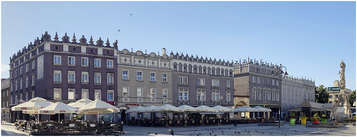
Figure 1. The western side of the Main Square in Racibórz from the early 1950s. Photo by the author (2022).
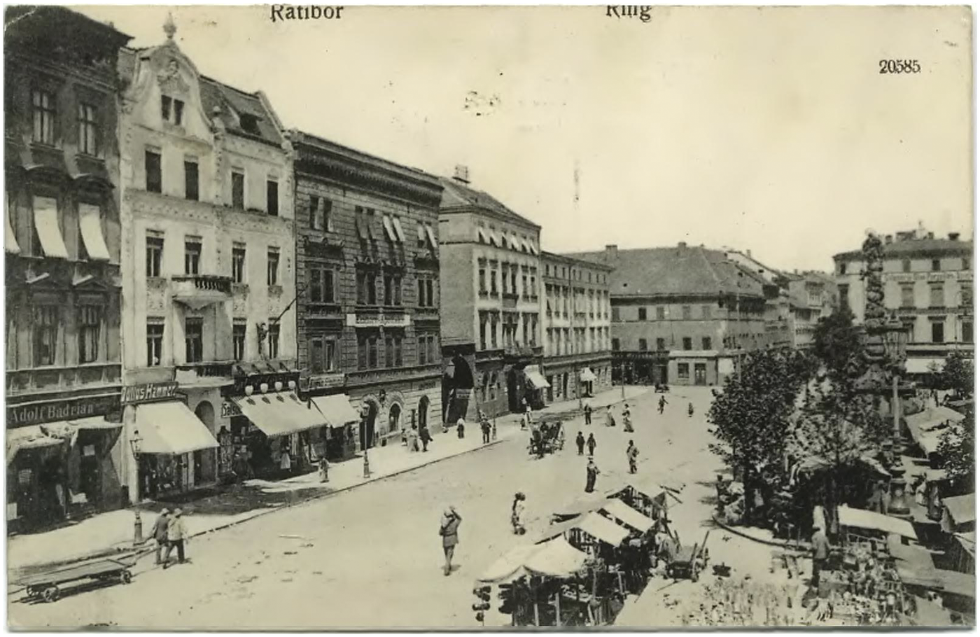
Figure 2. The western side of the Main Square in Racibórz on a 1906 postcard: Reinicke & Rubin, Magdeburg, Biblioteka Śląska, Katowice, ŚIBZZ, Sig. PA 594, public domain.
This article is concerned not only with the polonization of the town but also with its reshaping into a so-called socialist city. The term is highly controversial and has been the object of many studies. Some authors have examined particular cities, especially model examples, whereas others have investigated the concept itself and the ways in which it differed from concepts such as ‘European city’ and ‘modernist city’.Footnote 9 No agreement exists on whether there was ever such thing as the socialist city or if and how it related to a specific model, or whether it adhered to the modern city concept or to European cities.
This article is informed by the literature on Polish architecture and urban planning during the period of socialist realism (also called Stalinist and socialist classicism). The 1949 speech by Edmund Goldzamt at the meeting of party architects is understood as the beginning of this period in Poland.Footnote 10 The socialist cities were to be built on the Soviet model while ‘avoiding a number of errors detected and overcome in the USSR’. ‘Socialist content in national form’ was to be strived for. This could be achieved, according to Goldzamt, by establishing ‘continuity between the old architecture and the new based on adopting, processing and developing healthy and progressive traditions, while rejecting bad and reactionary ones’. Modernism, the garden city model as well as ‘bourgeois nationalism’ in architecture and urban planning were rejected. Instead, Goldzamt called for a cohesive city with a clearly defined centre that would be ‘spatially dominant (though not necessarily vertically)’ and which would house social institutions.Footnote 11
From those, admittedly vague, slogans as well as major projects such as the new city of Nowa Huta (near Cracow) and Warsaw’s urban development, we can deduce how a socialist city in the period of socialist realism was imagined.Footnote 12 In terms of its look, it was oriented towards the past with the use of historicizing architecture. At the same time, modern urban issues were also addressed, such as traffic circulation, access to green spaces and social infrastructure (e.g. kindergartens and schools). As for urban planning, one can notice the use of monumental axes and representative squares, which could be used during political celebrations and public events. As far as urban morphology was concerned, perimeter block development was preferred (instead of modernist solitaire), thus retaining the traditional street model. However, backyards were not used. Instead, large courtyards across whole city blocks were a common feature. Finally, city blocks were not closed off, but rather open since a connected city landscape was aimed for.
Khrushchev’s turn towards the industrialization of the building sector and his condemnation of the excessive spending for Stalinist architecture and urban planning in the Soviet Union in 1954, as well as the 1956 political condemnation of Stalinism, brought about the demise of socialist realism in Poland as well.Footnote 13 Modernism in architecture and urban planning, rejected in 1949, was embraced anew in 1956.
Last but not least, this phase was also marked by the so-called Polish School of Conservation. It was fully applied only in Warsaw, and partly in Gdańsk, Wrocław and Poznań, but it formed an important backdrop for development even in provincial Racibórz.Footnote 14 The School of Conservation called for a reconstruction of historical forms in cities destroyed during the war, on the bases of written and iconographic sources. The aim was to create a consistent urban landscape with an idealized image of the past. For this reason, for instance, eclectic architecture from the nineteenth century was not restored and even removed, if it survived the war, as it was not considered ‘good’ architecture. Faithful reconstruction was only applied to the most important religious and secular structures, while less important buildings were only restored in terms of height, volume and façade design. The Polish School of Conservation saw the whole historic district as an object of its interest (including a town plan), not just individual buildings. For this reason, where information was lacking on the historical situation of individual buildings or even whole sections, a creative design was used. At the same time, improvements in terms of sanitary standards and circulation of traffic were accepted.
Methodology
This article is based on a close reading of archival material from the State Archives in Opole, Racibórz and Katowice as well as additional documents such as architecture journals. These sources were analysed in order to understand the reconstruction process of Racibórz, including who was involved and what the logic was guiding the development.
There are 12 maps preserved from 1949 to 1952 that were made in the process of developing the post-war reconstruction of Racibórz. No maps from the immediate post-war years have been preserved. The focus of the existing maps varies; some are inventories of the situation on the ground regarding the war damages, the state of historical monuments and green areas in the city. Others are oriented towards the future, including dividing the city into different zones depending on land use, the planned height of buildings and planned location of public facilities.
This article focuses on two maps from 1952.Footnote 15 One is entitled ‘historical study’ and shows the assumed look of the city during the fifteenth century. The other, entitled ‘Racibórz, [building height]’ provides an overview of the reconstruction intention, including the location of the public buildings and services. These two documents were selected because of their thematic focus, level of detail and preservation state. By comparing the two maps, it is possible to examine if and how the assumed urban morphology of the medieval period influenced the planning of the socialist city. Other maps, in particular war damage maps, were used partially to extract information not available from the two main sources.
To analyse the maps in detail, it was necessary to georeference them. This was conducted using QGIS software (version 3.22.11-Białowieża), with common reference points (such as churches, school buildings and a few squares) applied to all the maps. Manual control was conducted for each map to confirm that the process was successful, which meant ensuring that the building used for referencing as well as streets on the historic maps matched those on the Open Street View map. If necessary, the process was renewed until a satisfactory level of georeferencing’s precision was achieved. The overlay of the maps was thus possible, which in turn allowed for the examination of patterns and a better understanding of the cartographic images.
The contextualization of the cartographic material was achieved by a close reading of the archival sources, such as minutes of the municipal and regional (voivodeship) councils, documents regarding the historical monuments and files on building construction and demolitions in Racibórz. This allowed an understanding of not only who made the plans and on what basis but also what the objections raised at the time were. However, not all the documentation of the time has been preserved, and thus, some of the questions arising from the maps do not have a definitive answer.
Case-study
Racibórz (Ger. Ratibor) in Upper Silesia dates back to the medieval period, similar to many other settlements in the region. City rights (the so-called location privilege) were granted in the mid-twelfth century. It was first ruled by the dukes from the Piast dynasty and later by the House of Přemyslid. At first, it was an independent duchy; in the early fourteenth century, it became a fief of the Bohemian kings. From the first half of the sixteenth century, it was in the hands of the Habsburgs, who handed it to various nobles until Prussia acquired it during the Silesian Wars in the mid-eighteenth century.Footnote 16 In the inter-war period, it became a border town, with a Polish–German border crossing located about 4 km from the Main Square. As a result of World War II, the town was taken over by Poland. As early as June 1946, Racibórz was incorporated (only until August 1950) into the Silesian Voivodeship, which meant that technically it was no longer part of the Northern and Western Territories, that is, a ‘reclaimed’ town.Footnote 17 In spite of these administrative changes, it is undeniable that the city still belonged to the ‘Recovered Territories’, given its history outside the Polish realms.
Despite its long history, the city was not perceived to be of particular significance when it comes to historical monuments. The 1894 register of monuments lists three churches, two columns (Marian column and Nepomuk figure), a city wall (only a small portion of which survived) and architectonical details in a few houses.Footnote 18 In 1927, Klemens Raffelsiefen, the town planning officer (Stadtbaurat), was more generous, and recognized not only the above, but also the synagogue and the remains of the castle, the city hall (‘calm and elegant’), the district court and a few gabled houses.Footnote 19 However, since he believed that the city was not visually appealing enough, the town planning office also made a step by step effort to remove the ugliness (Hässlichkeit) from the streets. A 1949 map showing the city’s historical monuments marks not only the churches but also a large number of other buildings, 60 buildings in total within the borders of the walled city, plus the castle on the other side of the river. Of these historic buildings, 39 were labelled as destroyed.Footnote 20 At no point in the existing post-war documents is the ‘Germanness’ of the historical monuments mentioned.
Racibórz was a small town when it was acquired by Prussia in the mid-eighteenth century, with less than 2,000 inhabitants. Industrialization dramatically changed the situation. At the beginning of the nineteenth century, its population was approximately 3,500, but by 1910, it had reached 38,000. In the 1921 Upper Silesia plebiscite, the city voted decidedly in favour of Germany: 90.3 per cent of the votes, with a voter turnout of 97.4 per cent. Following the Potsdam Agreement (2 August 1945), the city’s population became virtually Polish. By the end of the war, the population had declined to just 3,000 but reached 20,000 at the end of 1945. The pre-war number of inhabitants was not reached again until the late 1970s.Footnote 21
As mentioned, the Polish government claimed a historical (and moral) right to Racibórz (together with all the ‘Recovered Territories’) based on the link between the (communist) Polish state after World War II and the medieval Slavic states. A good example of this narrative at the local level can be found in a booklet prepared for an exhibition in the Racibórz museum in 1955 on the occasion of the 10-year anniversary of the Polish People’s Republic: ‘After 600 years of slavery and foreign rule, with the victory over fascism, over Teutonic barbarism, Racibórz together with all of Silesia returned forever to its Polish Motherland.’Footnote 22 It is worth noting here that the People’s Republic of Poland was proclaimed only in 1952 (in the new constitution), which shows that precision was not always a feature of public history in the post-war period.
World War II meant significant changes for the city in terms of not only the political regime and population (ex)change but also its urban structure and morphology. The limited archival material does not allow us to precisely say what was destroyed during the war, what in the wake of the Soviet takeover of the city, and what was demolished in the first post-war years. The literature varies greatly in its assessment of war damages, from approximately 60 per cent up to 100 per cent.Footnote 23 While it was certainly not wiped off the face of the Earth, it was indeed heavily damaged. This meant that the Polish authorities faced a triple challenge: urban reconstruction, reshaping it into a socialist city and remaking it into a Polish city. While the Silesian region as a whole played an important role in the communist plans for the Polish economy, with its emphasis on heavy industry, Racibórz itself had only limited importance in this strategy. Its economy was based on the food sector (sugar, chocolate and confectionery plants), household chemical works as well as a boiler electrodes factory.Footnote 24 The municipal documents suggest that this modest industrial base did not translate into big resources for reconstruction and city development. For example, in February 1957 the urgent need to secure the train station building against collapse was discussed at the city council.Footnote 25 This, however, did not happen for many years. A new building was opened only in 1979.Footnote 26
For other cities in Poland, the post-war reconstruction took even longer, for instance, the ruins of the historic centre of Głogów (Ger. Glogau) were cleared of debris and left as a wasteland until the 1980s.Footnote 27 It was not a unique case, in fact around 30 cities in Poland shared a similar fate.Footnote 28 This shows that, despite the difficulties, the reconstruction of Racibórz was not particularly protracted in time, but rather fits into the post-war history of Polish cities.
Delayed reconstruction
The Polish administration arrived in Racibórz in early May 1945, and soon afterwards, efforts were made to restore the city. This post-war reconstruction continued through the 1950s, with or without a plan. The lack of a cohesive plan meant that the decisions about demolitions were made on an ad hoc basis. This was, however, far from ideal, because this made it more difficult to determine which buildings should be demolished and which had to be preserved.Footnote 29 In June 1949, the municipal council (Miejska Rada Narodowa) was reprimanded for conducting rubble clearance in the city without consulting the regional planning authorities or the conservation authority. Consequently, historical monuments were demolished, which was utterly unacceptable, in the view of the state authorities.Footnote 30
The year 1949 was an important one for the post-war reconstruction of Racibórz. In June, the Silesia and Dąbrowa Voivodship Office (Urząd Wojewódzki Śląsko Dąbrowski) ‘recognized the old town of Racibórz as a monument within the medieval foundation of the town…for its historical, artistic and cultural character’.Footnote 31 It is worth noting here that the protection was granted to the historic layout of the old town, not buildings standing within its borders. These had to be enlisted separately. For instance, the Church of the Assumption of the Blessed Virgin Mary in Racibórz was designated as a monument as early as January 1948, whereas remains of the city fortifications along Drzymały Street were given such a status only in 1964.Footnote 32
Moreover, also in 1949 a series of plans were made. A map of war damages covering the entire territory of the municipality was drawn that used city blocks as units, as well as a detailed map of the centre showing individual buildings.Footnote 33 Furthermore, two additional maps of the city centre were created: one showing historical monuments and the other depicting greenery and roofs.Footnote 34
This, however, did not seem to impress the municipal authorities very much. In October 1949, they questioned the regional administration about the situation. A month later, they were informed that the master plan for the entire city and a detailed plan for the city centre had been commissioned at the Cracow branch of the Central Office of Planning and Architectural and Building Studies (Centralne Biuro Projektów i Studiów Architektonicznych i Budowlanych). At the same time, a detailed inventory of the existing built structures had been commissioned, which would allow the preparation of a detailed plan for the city. These documents were expected to be delivered in time to allow the beginning of construction as had been planned.Footnote 35 In July 1951, the municipality was informed that while an initial cartographic plan covering such topics as zoning and green spaces and designation of the historic area had been approved, the master plan remained uncommissioned. Moreover, a detailed map for the centre was commissioned in the office in Cracow only in the spring of 1951.Footnote 36 This was followed two months later with the information that an inventory was almost complete and that the detailed map had just been finalized.Footnote 37 Despite this, in 1952, Helena Sawczuk-Nowara, an architect from Cracow, was tasked with preparing a cartographic inventory of the situation in Racibórz in connection with the development of a spatial development plan. This work had to be accomplished in just three months.Footnote 38 It seems that she delivered on time, and this project was discussed and reviewed by two other experts. Also in 1952, the maps at the centre of this article were drawn. In March 1956, the city council was informed that the urban reconstruction plan was ‘in the final stages of development’.Footnote 39
In 1955, the internal report noted that Racibórz was one of only three cities in the then Voivodeship Opole to have a development plan. However, the plans drafted at the height of the socialist realist period were not looked at kindly in the following years. Already in late 1955, parts of the project were criticized for creating ‘architectural chaos’.Footnote 40 In November 1956, it was severely criticized by the city council, and a need to ‘civilize the architecture of our city’ was voiced.Footnote 41 In 1957, amendments to the development plans were approved by the regional administration.Footnote 42
The protracted process of preparing reconstruction plans, together with the scale of post-war demolitions, caused significant resentment in the city. In August 1950, one of the members of the city council complained about the slow pace of preparation of the development plans, which in his view had been dragging on for the previous five years.Footnote 43 A year later, another member of the city council called for more buildings to be rebuilt and fewer to be demolished, particularly because of the historic character of the city.Footnote 44 In January 1952, the city council unanimously demanded the reconstruction of the city centre, as it was the area that drew people to the city.Footnote 45 In 1956, at a session of the regional assembly (Wojewodzka Rada Narodowa), it was noted that the reconstruction of Racibórz was ‘not rapid and was not at a large scale’.Footnote 46 A member of the praesidium of the city council admitted in November 1957 that ‘it will still be many more years before Racibórz is fully rebuilt’.Footnote 47 And this was certainly the case. The Silesian town was approaching the end of the 1950s as a city still visibly scarred by the war, far from closing the ‘post-war’ chapter of its history.
Socialist city
The best source for understanding what the city was supposed to look like according to the early 1950s plans is the map misleadingly entitled ‘Racibórz, [building height].’Footnote 48 Despite its name, it shows much, much more. It depicts the locations of all the important public services (kindergartens, schools, shops, etc.), hotels, churches and even the location of the May Day tribune (Figure 3).
This map envisaged an introduction of extensive green spaces to the city centre, the creation of a pond and the construction of houses along the streets with extensive green courtyards. While ‘corridor’ streets were retained, tightly built-up backyards were to be cleared up and replaced with generous green spaces. Since the existing street network was (largely) retained, the planned city blocks were not uniform in their shape and size. This is very visible if we compare planned buildings in the historic centre with the ones planned outside the green belt, which are much more regular (Figure 3). None of the perimeter blocks were to be fully sealed; the degree of their openness to the streets varied. With only a few exceptions, the plan foresaw placing buildings directly on street lines, without any front gardens.Footnote 49
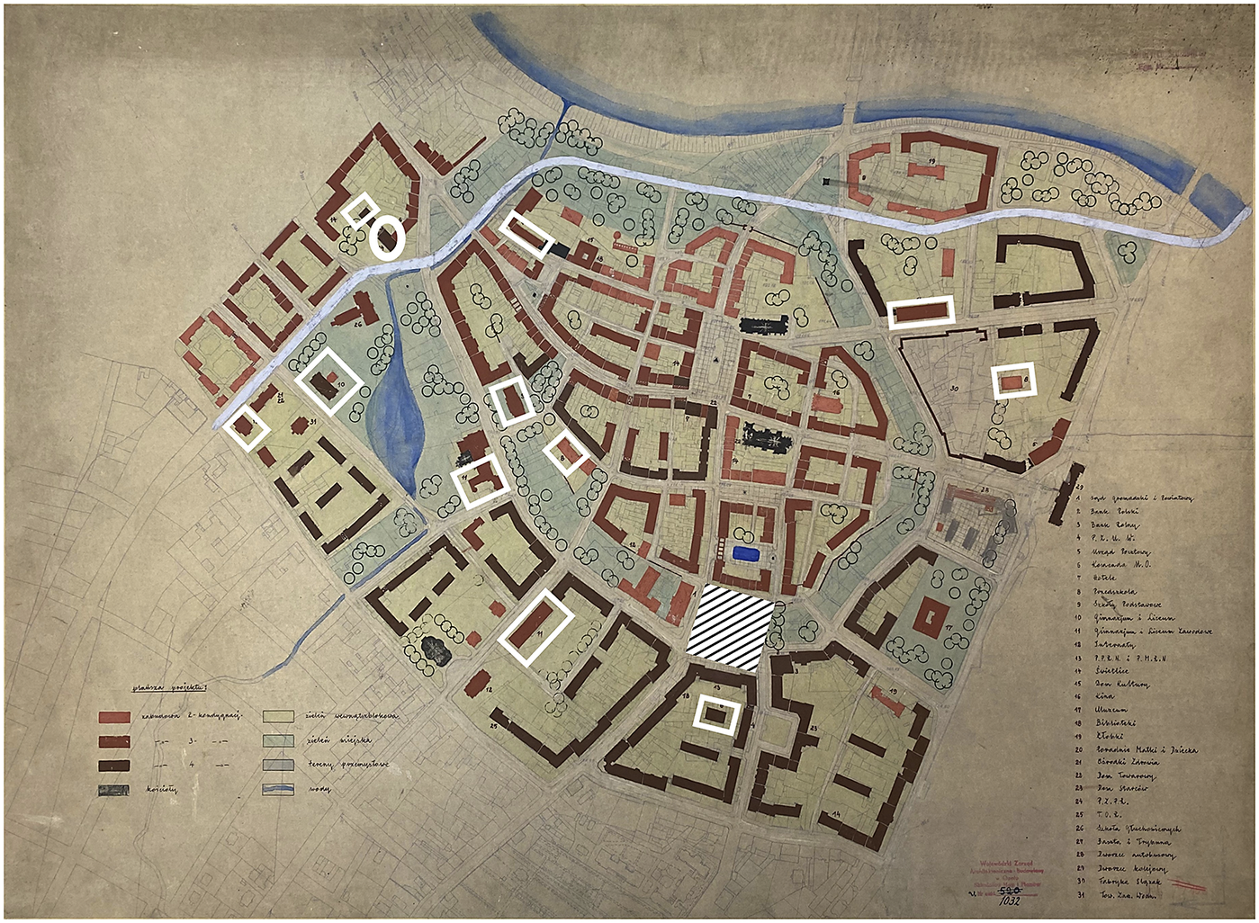
Figure 3. 1952 reconstruction plan of Racibórz. In white frames, educational institutions (i.e. kindergartens and primary and secondary schools) are highlighted. The seat of the Communist Party is in the white circle. The square for political demonstrations with the May Day tribune is marked using white and black stripes. ‘Racibórz, [wysokość zabudowy]’, 1952, 45/224/0/67/6105, Archiwum Państwowe w Opolu.
The 1952 map of the envisaged socialist Racibórz made it clear that quality housing lay at the heart of the new concept of the city. There were to be no dark yards; each house would overlook a green space. At the same time, traffic was to be kept away from the city centre housing area. A new road was planned from the west towards the north, likely to divert traffic from the centre. As mentioned above, multiple schools, shops and other facilities were planned in the immediate vicinity of the houses. A large new square with the May Day tribune was planned on the site of the houses destroyed during the war. There was also a seat for the regional administration. The headquarters of the Communist Party was situated at the northern end of the green belt surrounding the old city. The plan does not tell us what type of architecture was planned to line those socialist streets and squares. But overall, the plan shows a very clear, highly orderly and planned city, with the city centre turned into a comfortable housing estate.
The base map used for this 1952 plan allows us at closer inspection to grasp the scale of transformation envisaged for the city, as it shows the outline of the buildings that were to be removed in the process. This becomes even clearer when we compare this map with the ‘inventory of damages’ from 1949 (Figure 4).Footnote 50 Evidently, no part of the historical centre was left unchanged. To create the buildings flanking the empty courtyards, the previously existing structures were not included in the reconstruction and standing ones were to be demolished. Rzeźnicza (Butcher) Street, going westwards from the Main Square, was basically turned into an inner block alley. Furthermore, the city’s historical core was supposed to be separated from the rest of the city by a green belt. To achieve this, buildings were demolished on the western side of the old city as well as between the historic city and the river (along Odrzańska (Oder River) Street). Last but not least, parts of the city walls were to be recreated in the green belt from the eastern and northern sides.
Historical plans and monuments
As mentioned, a set of maps were drawn as part of the reconstruction plans. In 1952, ‘for internal use’, a ‘historical study’ of Racibórz was drawn by Marian Dziewoński, an architect from Cracow.Footnote 51 It was based on a detailed (possible cadastre) city map and depicts the historical layout. Since no documents accompanying it have been preserved, it is impossible to ascertain which time period it shows or what documents were used to create it. Additionally, a year later, Dziewoński made a ‘historical plan’ for part of the historic centre, which does not differ much from the previous map.Footnote 52 The only major difference is that it does not show the city walls on the northern side.
A year later, an unknown person made a different map, showing a ‘presumed town plan in the fifteenth century’ based on the 1812 map made by André Wirheim.Footnote 53 The comparison between the two maps by Dziewoński and this ‘presumed town plan’ shows very little divergence, the course of the city walls being the only noticeable dissimilarity, albeit only a minor one. It can thus be assumed that both maps made by Dziewoński attempted to depict the historic morphology during the fifteenth century and that this time period was taken as the ‘original’ for Racibórz.
No explanation could be found for why this map was adopted as the base map, and therefore why the fifteenth century was adopted as the ‘original’ state of Racibórz, given that it was not in any direct way related to the town’s Polish past. Symbolically, the fifteenth century was not an obvious point of reference, especially for the communist regime, which preferred the early medieval history associated with the reign of the first Polish Piast dynasty, which ruled over territories as far as the Oder River (and thus over parts of the ‘Recovered Territories’).Footnote 54 For this reason, it can be assumed that the choice of a map showing the city in the fifteenth century was not on ideological but rather practical grounds. This is especially likely given that this was the only map of the city available for the medieval period. An almost identical approach was taken in another ‘recovered’ city, namely Elbląg (Ger. Elbing) in former East Prussia, where a map depicting the city in the fifteenth century was also used as a reference point.Footnote 55 Furthermore, creating such historical studies as a part of the post-war reconstruction process was obligatory and a whole series of such maps for different cities were drawn in the early 1950s.Footnote 56
In terms of the types of land used, Dziewoński’s maps distinguish between the following categories: green areas, residential buildings, outbuildings and city walls. Additionally, the 1952 map has the following categories: ‘churches’, ‘monasteries’ and ‘towers and bastions’, whereas the 1953 map distinguished between: ‘monasteries’ and ‘churches, towers, city hall’. The ‘historical study’ (1952) clearly depicts three streets towards the north, west and south (today’s Odrzańska, Długa, Nowa), as well as the Main Square as highly built-up areas, and the rest of Racibórz being less developed. No structures outside the city walls were shown; thus, the historical zone was singled out and cut off from its urban and natural (geographical) context.
Unfortunately, no additional information about these maps can be gleaned from the written documents. There is a description of the project by Helena Sawczuk-Nowara as well as two expert opinions: one by Alfred Fiebiger from Gliwice and the other by Kazimierz Smalec from Opole.Footnote 57 Neither expert mentioned the historical studies of Racibórz. Sawczuk-Nowara too refrained from mentioning any of these maps in her exposé and referred to the history of the place only once. In her words, while the area of the medieval city was an historic monument following the conservator-restorer’s decision (from June 1949), the buildings located there were not protected and thus could be demolished, except for a former brewery building. Such clearances were intended to provide light and greenery to the courtyards. It seems, therefore, that the post-war plans for Racibórz were rooted squarely in the concept of the socialist city and that historical studies were of no consequence. However, it was not that straightforward.
Medieval roots of the socialist city
How does the project for the socialist city compare to the historical studies of Racibórz in the fifteenth century? As mentioned in the introduction, the communist regime went to great pains to demonstrate that the ‘Western and Northern Territories’ were ‘recovered’. Olga Tokarczuk describes this process of polonization as making it more Slavic and more Piast-like (usłowiańszczyć, upiastowszczyć).Footnote 58 The Piast-Poland (from the name of the first dynasty) was identified with Poland stretching to the Oder River and contrasted with the Jagiellonian-Poland, which included lands in the east, in today’s Belarus and Ukraine. In terms of architecture, this was done in Racibórz by building houses on the western side of the Main Square in the neo-Renaissance, supposedly Polish, style. As mentioned, the façades are decisively different from how they looked in the pre-war period (see Figures 1 and 2). Of course, this contradicted the meta-narrative, as the Renaissance was, if anything, connected with the Jagiellonian period (sixteenth century) rather than with the earlier Piast dynasty.
However, whether the ‘recovery’ of urban history remained at the superficial level of building styles or went much deeper into the very plan for the city remains unclear. In this regard, the comparison between the two 1952 maps – the ‘historical study’ and the ‘building height’ plans – provides some insights.Footnote 59
The socialist Racibórz was by no means a simple recreation of the medieval Racibórz. While the street network was largely preserved, there were some very important changes. As mentioned above, Rzeźnicza Street, which can be seen in nearly all the historical plans of the city, was to be transformed into an intra-block alley. Similarly, the arch-shaped Młyńska (Mill) Street in the eastern part of the historical city, visible on the medieval plan, was also turned into an intra-block alley (see Figure 4). Second, in the southern part of the historic city, south from the city church, where according to the ‘historical study’, a street once existed between the gardens, a new structure was envisaged. According to the 1952 map, a yard flanked from all sides by houses and an arch(?) was to be created with a small pond in the middle. Neither of these corresponded to the pre-war situation (Figure 5). Browarna (Brewery) Street, which according to Dziewoński did not exist in the fifteenth century, was retained, as it existed in the modern city. Moreover, the greenery of the medieval period was replaced partly by the houses along the street. Similarly, the eastern part of the historical core, which supposedly was largely undeveloped in the medieval period, was not left empty, but was planned in a similar fashion to that on the western side. Finally, there was no plan to reconstruct the city hall in the middle of the Main Square. The Renaissance city hall building was demolished after the city fire in the eighteenth century and a new building in a classical style was not erected until 1825 in a different location on the Main Square.Footnote 60
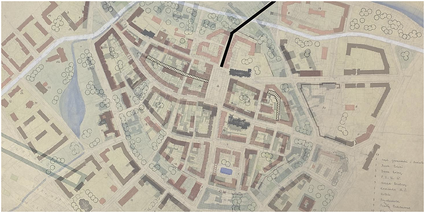
Figure 4. Overlay of the 1949 inventory and the 1952 reconstruction plan. Hatched are marked Rzeźnicza (Butcher) Street (left from the Main Square) and Młyńska (Mill) Street (right from the Main Square). Odrzańska (Oder River) Street is marked in black. The white line on the western and northern side indicates a planned bypass of the old city. ‘Racibórz, inwentaryzacja urbanistyczna Starego Miasta, stan zniszczeń’, 1949, 45/224/0/67/6109, Archiwum Państwowe w Opolu; ‘Racibórz, [wysokość zabudowy]’, 1952, 45/224/0/67/6105, Archiwum Państwowe w Opolu.
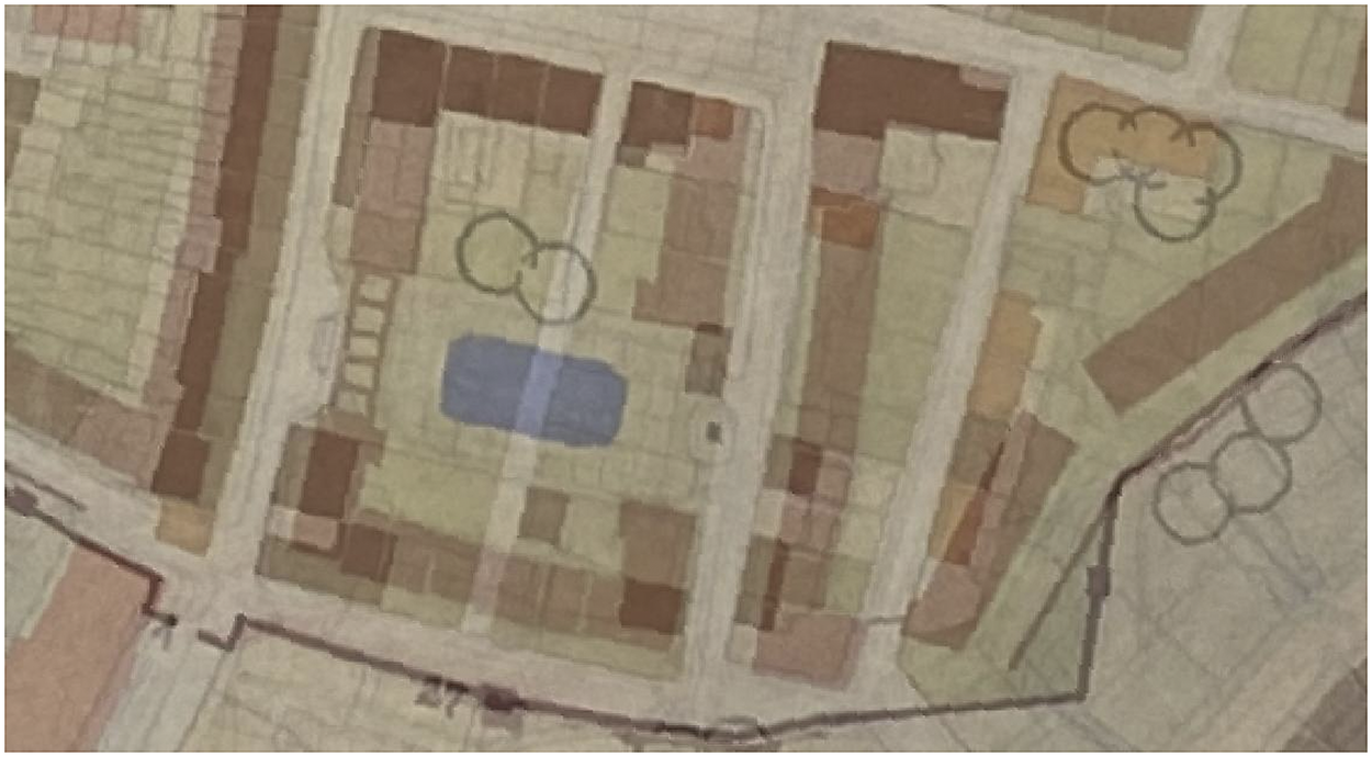
Figure 5. Overlay of the 1952 reconstruction plan and the 1952 ‘historical study’ showing the southern edge of the historical centre. A green courtyard with a pond (blue rectangle) was planned on the site of a medieval street. ‘Racibórz, studium historyczne’, 1952, 45/224/0/67/6102, Archiwum Państwowe w Opolu; ‘Racibórz, [wysokość zabudowy]’, 1952, 45/224/0/67/6105, Archiwum Państwowe w Opolu.
The socialist Racibórz did not simply ignore its medieval roots, however. First, the city was to regain parts of the city walls that dated back to the thirteenth century and were demolished in the late eighteenth and early nineteenth centuries. The green belt surrounding the historical core traced the historical line of the city walls.Footnote 61 Surprisingly, the plan indicated an intention to build some sort of gate on the northern side of the city. The available sources provide no rationale behind it.
The destruction of the houses still standing in the early 1950s was considered an acceptable price to create the green belt surrounding the city centre. Furthermore, the newly built houses, in the form of a semi-closed quarter, also followed the borders of the medieval city. This is especially visible in the north, next to the newly built city gate, and along the western part of the green belt. Next to Odrzańska Street, the outside wall of a newly built house also follows the course of the city walls. Moreover, according to maps, no buildings were to stand beyond the line of the medieval walls. Those that were left after the war were to be demolished (Figure 6). Surrounding the historical core with a green belt was hardly a solution unique to Racibórz. On the contrary, it was commonly used in post-war Poland and was seen as the preferred solution in many cases. This urban strategy had been used throughout Europe since the nineteenth century and can be still found in many places today (e.g. Vienna, Würzburg, Cracow).Footnote 62

Figure 6. Fragment of the overlay of the 1952 reconstruction plan and the 1952 ‘historical study’ showing Orzanska Street in the middle of the picture. Planned houses on the right along the city wall. Some sort of city gate was planned, and no buildings were envisaged beyond this point. The circles symbolize the trees/plants. ‘Racibórz, studium historyczne’, 1952, 45/224/0/67/6102, Archiwum Państwowe w Opolu; ‘Racibórz, [wysokość zabudowy]’, 1952, 45/224/0/67/6105, Archiwum Państwowe w Opolu.
Finally, there was a plan to redirect the small stream towards the edge of the historical core (Figure 4). The comparison with the fifteenth-century map explains the possible motive here. Namely, the stream was supposed to follow the course of the city walls, resembling a moat. This would serve the dual purpose of highlighting the border of the historic district, even without the need to recreate the walls, and of emphasizing the only entrance to the centre from the west through a bridge over the ‘moat’ onto Długa Street, the historical west–east road through the city.
A blessing in disguise
Of course, radical plans to reshape the existing urban morphology were not a rarity in the late 1940s and early 1950s. A desire to eliminate ‘insalubrious’ quarters, provide quality housing and allow easy circulation of traffic shaped plans drawn across Europe.Footnote 63 In fact, an American architect regretted that the US cities were not bombed, thus robbing them of the opportunity for a glorious reshaping.Footnote 64 In this sense, there was nothing particularly unusual in the way architects imagined post-war Racibórz.
Where Racibórz deviates from well-known patterns of recovery is how the project was prepared and what it aimed to achieve. First, the municipality, its leaders and the inhabitants were not involved in the planning process. According to the city council minutes, neither the architects nor the regional party and state functionaries bothered to ask or even inform the locals about the reconstruction of their city. It was very much a top-down affair. No trace of any involvement by anyone from the city could be found. Notably, however, the city also experienced a radical change in 1945 in terms of its population. Predominantly German-speaking inhabitants were replaced by those whose mother tongue was Polish. Racibórz, with a population of 49,724 in 1939, shrank to 3,000 in May 1945, but the population bounced back to 20,000 in December of that year.Footnote 65 Moreover, the fact that it was treated as an object rather than a subject of planning might also be connected to both its size and the lack of a strong local elite.
This disempowerment was not necessarily a feature of post-war reconstruction processes in all cities in Poland. For instance, in the case of Szczecin (Ger. Stettin) there were indeed disagreements among architects and city planners involved in the process, both from the local institutions as well as external actors.Footnote 66 Similarly, in Chemnitz (from 1953, Karl-Marx-Stadt) in East Germany there were also lively debates and negotiations on the best strategy for post-war reconstruction and remaking it into a socialist city.Footnote 67 The very top-down approach in Racibórz arguably was a result of its small size and weakness (or absence) of the local elite. What does seem typical for many socialist cities is the very limited influence of the inhabitants of the city, as the process was very much technocratic in nature.
Using the war’s destruction to ‘resurrect’ the past was not unique to Racibórz. In particular, post-war ‘correction’ of façades to create a desirable image of the city was quite common.Footnote 68 Many cities, including Saint-Malo in France, were reconstructed in an historical fashion, but with some ‘adjustments’ for the needs of modern housing, and making it somewhat friendlier towards cars.Footnote 69 We can clearly see it in the case of Racibórz (Figure 7). While building lines in the Main Square remained unchanged and this was also the case for some smaller streets, others were planned for a major reshaping. It is very clearly visible in the case of Długa Steet; its north side was to be set back, thus widening it. Considering that the old town was planned as a housing estate, it was more to do with the quality of apartments (especially provision of sunlight in the flats), than the needs of motorized traffic. It could be argued that those changes were intended to provide a more ‘legible’ city plan as well as a more ‘unified’ image of the streets.

Figure 7. Fragment of the overlay of the 1952 reconstruction plan and the 1949 ‘record of destruction’ showing Rzeźnicza Street in the middle of the picture and the Main Square on the right. The solid lines show the unchanged building lines, the dashed lines show the change of the planned alignment lines. The shaded polygons show the quarters to be demolished. ‘Racibórz, inwentaryzacja urbanistyczna Starego Miasta, stan zniszczeń’, 1949, 45/224/0/67/6109, Archiwum Państwowe w Opolu; ‘Racibórz, [wysokość zabudowy]’, 1952, 45/224/0/67/6105, Archiwum Państwowe w Opolu.
It is precisely this tension between the future and the past (with disregard for the present) that makes Racibórz an interesting case-study for post-war urban planning. Undoubtedly, it fits the scheme of a socialist city, but it also draws attention to factors other than political ideology and modernist concerns. The revival of the (remodelled) historic city was arguably consistent with the principle of socialist realism of developing a ‘progressive tradition’.Footnote 70 Furthermore, it was used to legitimize the communist regime by placing it within a national metanarrative. At the same time, recalling the past helped to justify Polish rule in the ‘Recovered Territories’.
Conclusions
At a meeting of the MPs from Racibórz with the members of the city council, the praesidium and the city’s architect in November 1956, an intense critique of the city’s reconstruction was debated. Termination of the ‘production of false monuments’ (i.e. Neo-Renaissance architecture) was demanded. Instead of this, a city centre suitable for motorized traffic should be designed, according to the participants of the meeting. Moreover, ‘service points’ located in the centre should serve the whole city. Thus, the concept underlying the whole project – city centre as a housing estate – was indirectly questioned. According to the participants, this view was shared by the population of the city at large.Footnote 71 This reflected the climate of the late 1950s and the rejection of urbanism as ‘national tradition’ during socialist classicism. The 1952 plan was never fully realized.
What do we make of the plans for the Polish and socialist Racibórz from the first half of the 1950s? Large parts of the project could be explained by socialist and modernist ideas about the city: getting rid of narrow and dark backyards and providing all housing with plenty of light, air and access to green spaces. The historic centre was to be turned into a housing estate with good social infrastructure, with traffic redirected away from the area. A political agenda is evident behind the plan: a large square is suitable for political demonstrations and serves as a prominent location for the state and party administration.
However, this alone is insufficient to fully explain the logic of the 1952 plans. It is highly doubtful whether the masters of modernism, or indeed advocates of socialist cities, would applaud a proposal to recreate parts of the city walls or build a city gate. However, it was very much in line with the ‘Polish School of Conservation’, which lobbied for the recreation of lost heritage.Footnote 72 But as this article demonstrates, it was not ‘just’ about building in a historicizing fashion but also about planning the city on historical foundations, even if that meant destroying buildings that survived the war. Buildings along Odrzańska Street were supposed to be built only as far as the medieval city reached, and the course of the houses followed exactly the course of the medieval city walls. This focus on the ‘Polish past’ of Racibórz meant, paradoxically, that the three historical churches were to remain the most important vertical elements of the socialist cityscape.
The recovery of the Polish past was, of course, selective and, at times, rather problematic. The fifteenth-century plan of the city was used to guide the reconstruction of the Polish and socialist city of Racibórz. However, in the fifteenth century, the city was no longer part of the Polish kingdom, nor was it ruled by the local branch of the Piast dynasty. More importantly, the recovery of the past did not mean that the historical structures had the utmost importance. As mentioned, ‘fake’ monuments were built while not reconstructing the actual historical monuments, except for churches. Reconciling the need to build a socialist and Polish Racibórz was not always easy. It could be argued that whereas architecture was used to demonstrate the (generic) Polish character of the city, urban planning was used to actually recover the urban history, even if it was not actually a Polish one. Finally, these plans were only partly realized. Thus, we cannot know what this city ‘national in form, socialist in content’ would really look like, but we can be certain that recovering the past was not merely a rhetorical figure but did affect the planning of the post-war city.
Acknowledgments
An early version of this article was presented at the Urban History Group Annual Conference 2023 – Recovery and the City. I am very grateful to Dr Laura Demeter (Otto-Friedrich University Bamberg) who took her time to read and comment on this article, which helped in its development.
Funding statement
This research was supported by the German Federal Ministry of Education and Research (Bundesministerium für Bildung und Forschung, BMBF) Project UrbanMetaMapping: Planung (01UL2004C).


 Open access