

Introduction
Ice-sheet mass-balance fluctuations influence global sea-level and ocean thermohaline circulation changes. However, the state of ice-sheet mass balance remains imprecisely known (Reference Van der VeenVan der Veen, 2002). Greenland ice sheet surface mass-balance components have been resolved by statistical compilations of available observational data (e.g. Reference Ohmura, Calanca, Wild and AnklinOhmura and others, 1999; Reference McConnellMcConnell and others, 2001). However, these lack either the temporal dimension or complete spatial coverage. Recently, high-resolution limited-area regional climate models (RCMs) have filled this space–time gap over the Greenland ice sheet (e.g. Reference BromwichBromwich and others, 2001a, Reference Bromwich, Chen, Bai, Cassano and Lib; Reference Cassano, Box, Bromwich, Li and SteffenCassano and others, 2001; Reference Hanna, Huybrechts and MoteHanna and others, 2002; Reference Box and RinkeBox and Rinke, 2003; Reference Box, Bromwich and BaiBox and others, 2004) and have facilitated investigation of spatial and temporal variability of individual surface mass-balance components in a consistent frame. RCMs have thus provided the spatial resolution needed to resolve the ablation zone, spatial closure needed for whole ice-sheet mass-balance assessments, and annually resolved results useful for variability analyses. RCMs are commonly configured to be driven by available satellite, station and weather-balloon observations and can thus be thought of as physically based interpolators used to provide information for regions not benefiting from direct observations.
Automatic weather station (AWS) observations (Reference Steffen and BoxSteffen and Box, 2001) and glacier survey data (Reference Greuell, Denby, van de Wal and OerlemansGreuell and others, 2001) have proven vital in assessing RCM skill over the Greenland ice sheet (Reference Box, Bromwich and BaiBox and others, 2004). RCMs have proven to offer accurate representation of temporal variability (Reference BromwichBromwich and others, 2001a; Reference Cassano, Box, Bromwich, Li and SteffenCassano and others, 2001; Reference Box and RinkeBox and Rinke, 2003; Reference Box, Bromwich and BaiBox and others, 2004). However, apparently small systematic biases, particularly in near-surface vertical temperature and wind-speed gradients and radiation fluxes, can strongly bias modeled melt rates (Reference Box, Bromwich and BaiBox and others, 2004). Although it is unlikely that the propagation of systematic error will ever be eliminated from RCM output, AWS and glacier survey data make possible adjustments of the model output to deliver more reliable, observationally constrained estimates of surface climatology applicable in mass-balance studies. The overall uncertainty of modeled surface mass-balance parameters remains high owing to the fact that available in situ observations are few and were used for model tuning and therefore are unavailable for further testing. Details of the validation of the Polar MM5 RCM over Greenland are found in Reference BromwichBromwich and others (2001a), Reference Cassano, Box, Bromwich, Li and SteffenCassano and others (2001) and Reference Box, Bromwich and BaiBox and others (2004).
Reference Box, Bromwich and BaiBox and others (2004) demonstrated that summer temperature and annual precipitation variability explain >90% of the variance in modeled surface mass-balance totals spanning 1991–2000. Here, the temporal variability in temperature and precipitation is explored further, with a larger dataset spanning 1991–2003, as it pertains to the surface mass-balance variability. First, the absolute magnitude of interannual variability is presented and discussed. Second, trends in temperature, precipitation and surface mass balance over the ice sheet are examined. Temperature and precipitation variability is then analyzed in the context of a dominant regional atmospheric mode of variability, the North Atlantic Oscillation (NAO).
Absolute Variability: 1991–2003
The envelope of interannual variability as measured by the range in values over the period 1991–2003 for each model gridcell illustrates the concentration of temperature variability along the western slope and in particular near the ice-sheet margin (Fig. 1a). Reasons for this pattern include more variable wind direction along the western slope influenced by the NAO (Reference LiLi, 2003) and that sea-ice concentration is more variable along the west coast (Reference Cappelen, Jørgensen, Laursen, Stannius and ThomsenCappelen and others 2001). Links with the NAO are explored further toward the end of this paper.
Range in annual mean temperature (a), annual precipitation (range/mean) (b) and range in surface mass balance (c) in the Polar MM5 regional climate model over 13 years (1991–2003).
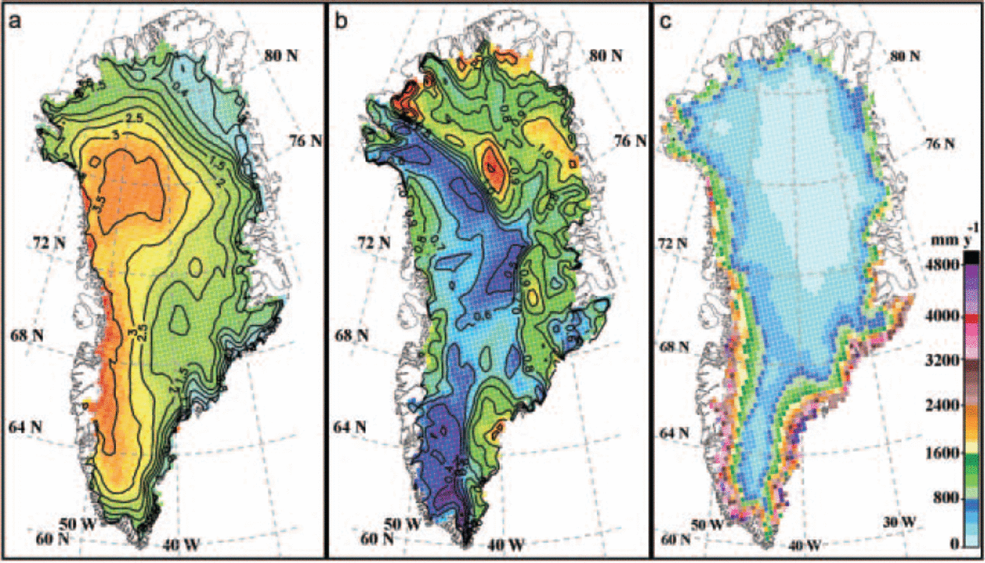
The variability in precipitation exhibits a similar pattern to other mass fluxes, i.e. largest absolute variability is found where fluxes are largest. The spatial pattern of precipitation normalized by its mean (Fig. 1b) exhibits a different pattern, one that suggests largest relative variability either where fluxes are small, i.e. at higher elevations and in the northeast zone of minimum accumulation, or in the southeast, where transient cyclones deliver precipitation highly variable in magnitude. Extremely large precipitation rates over the southeast spanning 2002 to early 2003 contribute to the variability maximum in the southeast. A belt of relatively low variability is evident extending from the northwest to the south. This pattern reflects relatively consistent precipitation delivered by prevailing westerly flow. Precipitation enhancement along windward slopes leads to a precipitation shadow on leeward slopes, manifesting in a pattern of relatively inconsistent precipitation along the leeward northeast. Over the northeast, on rarer occasions, precipitation arrives from the north and northeast (Reference LiLi, 2003), further contributing to the relatively large variability there.
Figure 1c illustrates how absolute surface mass-balance variability is greatest (up to 500 cmw.e.) along the ice-sheet margin. This pattern reflects the envelope of melt and accumulation variations between anomalous years. For example, melting was minimal in 1992 while precipitation was relatively large. In that year, the surface mass balance was ∼150 km3 more than the mean of nearly 200 km3. In an opposite extreme, 1998 temperatures were relatively high, and, combined with ∼40km3 below average precipitation and extremely large runoff (∼450 km3), the total ice-sheet surface mass balance may even have been negative for that year, not including the losses from iceberg discharge and basal melting.
Trends
Trends in temperature, precipitation and surface mass balance are apparent in the 1991–2003 Polar MM5 results. Seasonally, widespread temperature increases are evident except in parts of the north and northeast ice sheet. Some of this apparent warming can be attributed to Pinatubo (Philippines) volcanic cooling evident over Greenland (Reference Abdalati and SteffenAbdalati and Steffen, 1997; Reference BoxBox, 2002) in the early part of this analysis, i.e. 1992. Maximum warming was concentrated near the ice margin, where up to 3.0K warming is evident in the ablation season, here defined roughly as May– September (Fig. 2a). An average increase in melt duration of up to 1.7 weeks over these 13years is evident in southeastern Greenland, as annual temperatures there have increased by >3 K since the early 1990s. Annual temperature changes were positive across the ice sheet, 1.76K on average, and up to 6.8 K near the location of the melt-season temperature trend maximum.
May–September 2 m air-temperature change (a), annual solid and liquid precipitation change (cm w.e.) (b) and change in surface mass balance (cm w.e.) (c) over the 1991–2003 period. Minima (squares) and maxima (diamonds) are indicated.
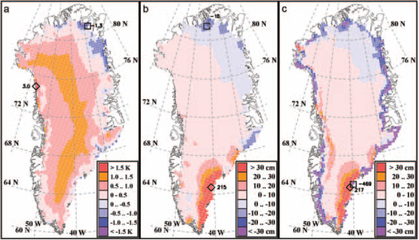
Overall trends in precipitation for the ice sheet were also positive (Fig. 2b). The southeastern maximum is influenced by a persistent and large positive anomaly, lasting from September 2002 to April 2003. However, the positive trend remains when 2002 and 2003 are excluded, implying that increasing accumulation in the southeast is part of a larger trend. Annual modeled precipitation (1991–2001) has a notable correlation (r > 0.7) with station records in southeast and western Greenland (data from Reference CappelenCappelen, 2003). Precipitation changes were negative and relatively small along the east and northeast, coinciding with decreasing temperatures, and still perhaps significant to regional mass balance owing to lesser accumulation rates.
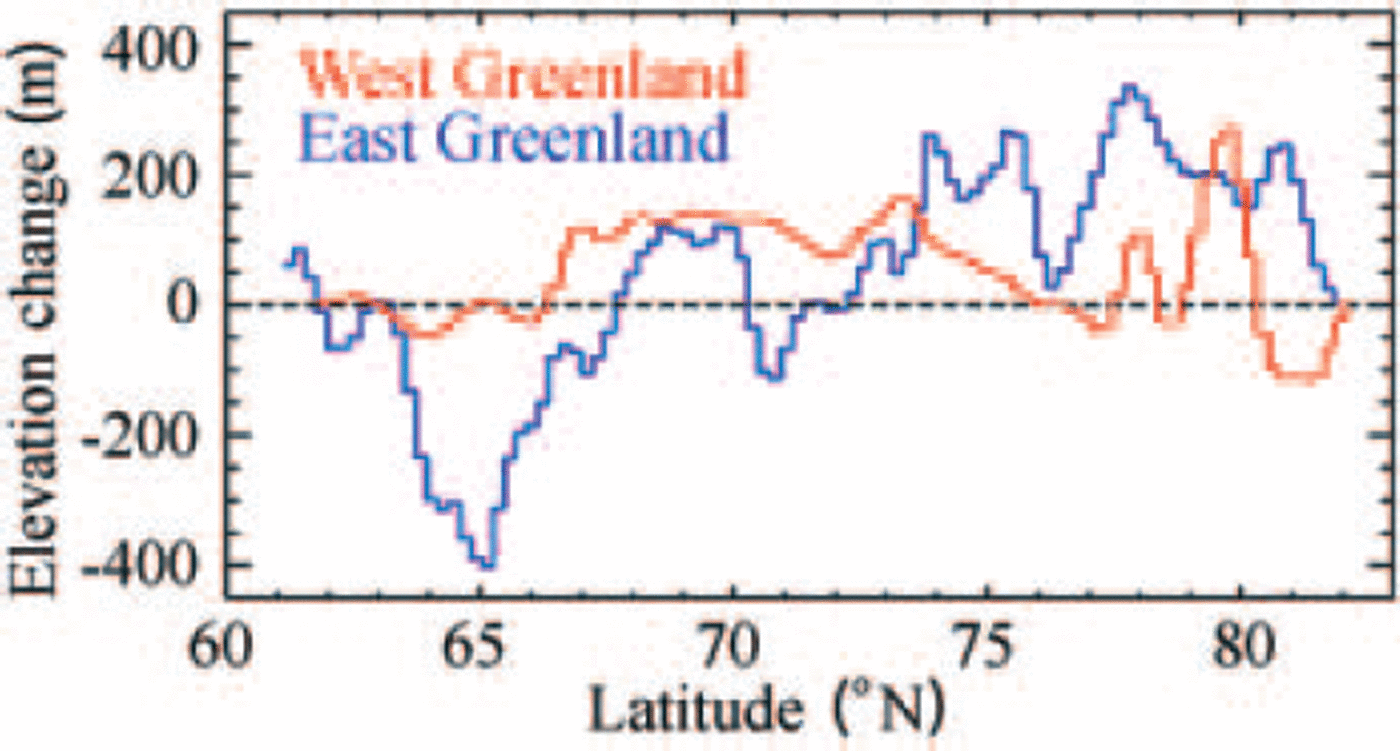
The combined effect of temperature and precipitation trends over this period is of increased ablation and increased accumulation. The net effect of these competing factors suggests that the temperature increases have dominated the surface mass-balance change in the ablation zone (Fig. 2c). Adjacent to the ablation zone, an acute increase in net accumulation is simulated. This pattern of a steepening elevation profile of net balance has been observed over many glaciers in the Northern Hemisphere (Reference Dyurgerov and DwyerDyurgerov and Dwyer, 2001). These results are in line with results of future scenarios by Reference Wild, Calanca, Scherrer and OhmuraWild and others (2003), whereby increases in precipitation offset the negative mass-balance tendencies of global warming. Here, however, a small negative surface mass-balance trend suggests that increased melting has dominated increased accumulation. Therefore, the ablation zone is simulated to have become wider, as suggested by overall positive trends in equilibrium-line altitude (ELA) over this period (Fig. 3). The peripheral thinning observed by repeat laser altimetry (Reference KrabillKrabill and others, 2000) can be at least partially attributed to the warming trends. A decrease in ELA in the southeast is caused by increases in precipitation. Only in the northeast does precipitation appear to dominate the surface mass balance, owing to decreases in both temperature and precipitation.
Change in ELA based on 1991–2003 trends.
North Atlantic Oscillation
The NAO represents a dominant mode of regional atmospheric variability around Greenland (e.g. Reference RogersRogers, 1997) and is gauged here as the pressure difference in hPa between Stykkishólmur, Iceland, minus Ponta Delgada, Azores. During negative NAO, relatively low pressure in the vicinity of southeast and southwest Greenland leads to a shift in the location of the Icelandic low (to the southwest), with more mesoscale lows in the Davis Strait region, causing wind direction changes that favor (southerly) warm air advection along the southwest coast and over the southern part of the ice sheet. Therefore, the NAO and southern Greenland temperatures are anticorrelated. Temperature sensitivity to the NAO over the ice sheet, as measured by the linear regression slope, is greatest for the southern part of the ice sheet, particularly in winter, with sensitivities up to -0.9KhPa–1 (Fig. 4, top row). Two standard deviations of the NAO fluctuations over the last three decades correspond to ±3.9 hPa in winter, implying roughly a ±3.5 K winter thermal sensitivity to the NAO. Spring and summer NAO sensitivities imply thermal sensitivities of ± 2 K and ± 1 K, respectively. Relevant to ablation is that the NAO explains 40% of the summer temperature variability along the west coast.
Greenland ice sheet seasonal temperature (top row) and precipitation (bottom row) sensitivity to the NAO. Statistical significance is indicated by green contour lines: dotted: >80%; dashed: >90%; solid: >95%. Statistical significance was measured as 1 minus the probability statistic p. NAO data were obtained from the Internet (c/o J. Rogers, http://polarmet.mps.ohio-state.edu/). Temperature sensitivity isolines are each 0.1 KhPa-1. Precipitation isolines are each 0.5 cm w.e. hPa-1 less than ±4cmhPa–1, beyond which they are each 2 cm w.e. hPa -1.
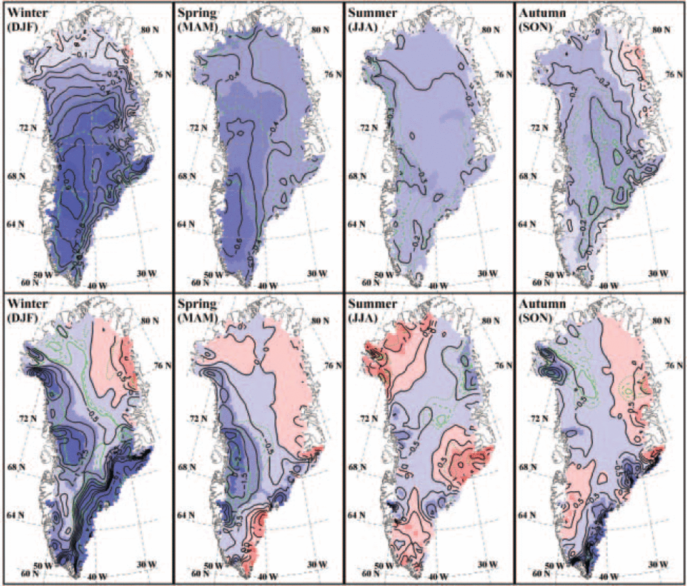
Modeled precipitation variability also contains significant links with the NAO (Fig. 4, bottom row). Consistent with the regional temperature sensitivity, positive NAO, i.e. cold Greenland, is associated with less precipitation, in the southeast by as much as − 11 cm w.e. hPa-1 in winter, when precipitation magnitudes and fluctuations are greatest. Up to 50% of the winter precipitation variability is explained by the NAO at locations adjacent to dominant storm centers. A belt of significant NAO precipitation sensitivity traverses the ice sheet from southeast to northwest in winter and autumn and has been identified in an ice-core accumulation record (Reference Appenzeller, Stocker and AnklinAppenzeller and others, 1998). Significant positive correlations with the NAO are evident in the northwest in summer, consistent with maximum precipitation there delivered in summer (Reference Steffen and BoxSteffen and Box, 2001).
Conclusions
Results from a 13 year simulation (1991-2003) from the Polar MM5 RCM reveal coherent spatial and temporal variability patterns in temperature, precipitation and surface mass balance over the Greenland ice sheet. Spatially, temperature variability is concentrated along the western slope of the ice sheet, while precipitation variability exhibits a more complex pattern that is related to the influence of topography on prevailing storm tracks. Up to half of the summer temperature variability is explained by the NAO, with largest NAO sensitivity in winter. Significant NAO links with precipitation are evident in regions dominated by regional storm centers, i.e. adjacent to the Icelandic and Baffin Bay lows. Temperature and precipitation trends over this period were positive over much of the ice sheet. The Pinatubo volcanic cooling enhances the apparent warming trend when only the decade of the 1990s is considered, the eruption having occurred in the early 1990s. Precipitation trends have the same spatial pattern and sign as temperature, suggesting an association of precipitation and temperature variability. An increase in ELA around much of the ice sheet and a consequent expansion of the ablation zone is evident in the model results. While increasing temperatures lead to an increase in the duration of the melt period and an increase in meltwater runoff, increases in precipitation mostly offset the negative perturbation in total ice-sheet surface mass balance. We may expect an increasing dynamic response of the ice sheet to this period of apparent warming and steepening of the ice-sheet balance profile, especially given that meltwater increases appear to accelerate ice-sheet velocities (Reference Zwally, Abdalati, Herring, Larson, Saba and SteffenZwally and others, 2002).
Acknowledgements
This work was supported by NASA grants NAG5-12407 and NAG5-11749. Thanks to A. Ahlstrøm, D. Dahl-Jensen and an anonymous reviewer for comments on the manuscript. This is Byrd Polar Research Center contribution 1307.


