


Tectonic geomorphology targets the rates of the dynamic process such as deformation, projection, erosion, etc. (Burbank & Anderson Reference Burbank and Anderson2001; Azor et al. Reference Azor, Keller and Yeats2002; Keller & Pinter Reference Keller and Pinter2002; Bull Reference Bull2007). Tectonic geomorphology relates to tectonics and geomorphologic processes (Burbank & Anderson Reference Burbank and Anderson2001), which can be categorised as characteristics indicating landform responses to active tectonics (Keller & Pinter Reference Keller and Pinter2002; Chen et al. Reference Chen, Sung and Cheng2003). Tectonic studies involve active tectonics and neo-tectonics.
Active tectonics is formally defined as tectonic movement and is expected to occur within a future time concerning society (Wallace Reference Wallace and Wallace1986), while neo-tectonics is the study of tectonic movement over a period ranging from the Neogene or Quaternary to the present (Wu & Hu Reference Wu and Hu2019). The application of geomorphic indices is a helpful way to analyse active tectonic subjects. These indices play an imperative role in understanding the essence of movements, as well as interpreting the regions' tectonic status. Among the quantitative and qualitative methods that are considered to investigate the active tectonics, quantitative assessment is essential for geosciences research to evaluate landforms using measurable indices (Lari et al. Reference Lari, Ansari and Ansari2016).
Geomorphologic indices have been used to assess active tectonics in different regions of the world, such as the SE mountains of Spain (Silva et al. Reference Silva, Goy, Zazo and Bardaji2003), the Sierra Nevada mountain range of Spain (Perez-Pena et al. Reference Perez-Pena, Azor, Azanon and Keller2010), the Hindu Kush mountains of northern Pakistan (Mahmood & Gloaguen Reference Mahmood and Gloaguen2012), the SW coast of India (Markose & Jayappa Reference Markose and Jayappa2013), central Anatolia in Turkey (Yıldırım Reference Yıldırım2014), the Van basin in eastern Turkey (Selçuk Reference Selçuk2016), the Himalayan basin in India (Dubey & Satyam Reference Dubey and Satyam2018), the northwestern coast of Algeria (Benbakhti et al. Reference Benbakhti, Maouche, Belhai, Harbi, Ritz, Rabai, Rezouk and Doumaz2018), the Langshan mountains in northern China (He et al. Reference He, Cheng, Rao, Chen, Hu, Yu and Yao2018), and the Zagros mountains in northern Iraq (Obaid & Allen Reference Obaid and Allen2017; Obaid & Allen Reference Obaid and Allen2019; Zebari et al. Reference Zebari, Grützner, Navabpour and Ustaszewski2019). For instance, Yıldırım (Reference Yıldırım2014) has noted that the geomorphic indices are compatible with the general relief of the mountain front and differential uplift along the fault zone of central Anatolia. In addition, Selçuk (Reference Selçuk2016) has reported that the geomorphic indices of mountain front sinuosity and valley morphology can reflect the high-activity tectonics along the fault lineaments of eastern Anatolia. Benbakhti et al. (Reference Benbakhti, Maouche, Belhai, Harbi, Ritz, Rabai, Rezouk and Doumaz2018), in a study on the coastal area of Algeria, revealed that elusive active tectonics characterised by geomorphic indices could aid in the evaluation of regional seismic hazards. An analysis by He et al. (Reference He, Cheng, Rao, Chen, Hu, Yu and Yao2018) in northern China revealed that the quantitative geomorphologic indices could explain the disequilibrium landscape responding to active rock uplift and channel incision.
Due to its systematic structure and relevant results to assess tectonics sensitivity, many researchers have implicated this method in Iran, such as Dehbozorgi et al. (Reference Dehbozorgi, Pourkermani, Arian, Matkan, Motamedi and Hosseiniasl2010), Eynoddin et al. (Reference Eynoddin, Solgi, Pourkermani, Matkan and Arian2017), and Taromsari et al. (Reference Taromsari, Dehbozorgi, Nozaem and Yassaghi2018). Tectonically, Iran is an active region with massive historical earthquakes, which is located along the Alpine–Himalayan belt dividing the Eurasian from the Africa plates (Mansouri Daneshvar et al. Reference Mansouri Daneshvar, Ebrahimi and Nejadsoleymani2018). Historically, Ambraseys & Melville (Reference Ambraseys and Melville1982) and Berberian (Reference Berberian1994) have compiled a comprehensive historical catalogue for Iran earthquakes, revealing the destructive earthquakes over the last centuries (e.g., Bastam M7.2 in 1890 and Quchan M7.0 in 1893). Significantly dangerous earthquakes have recently stricken Iran, such as Saravan M7.8 in 2013 and Kermanshah M7.3 in 2017 (USGS 2018). Tectonic activity in Iran relates to elevation, volcanism, and active faults (Zamani et al. Reference Zamani, Sami and Khalili2012). Hence, the mountainous basins are prone zones to active tectonics of Iran. In mountainous basins, active tectonics can be observed as contributing to up–down elevated topography resulting from tectonic and erosive processes (e.g., Andermann & Gloaguen Reference Andermann and Gloaguen2009; Bull Reference Bull2009; Perez-Pena et al. Reference Perez-Pena, Azanon, Azor, Delgado and Gonzalez Lodeiro2009).
The Zagros mountains have active tectonics with a motion rate from 16 mm per year at the apex of the Arabian promontory to 26 mm per year in eastern Iran (Vernant et al. Reference Vernant, Nilforoushan, Hatzfeld, Abbassi, Vigny, Masson, Nankali, Martinod, Ashtiani, Bayer, Tavakoli and Chery2004; Allen & Talebian Reference Allen and Talebian2011). The main part of landform deformation in the Zagros mountains is the fold-and-thrust belt (FTB), as a principal element in the Arabia–Eurasia continental collision (Allen & Talebian Reference Allen and Talebian2011). From a topographic view, active thrust and reverse faulting is relatively confined to the lower relief in this region and strike-slip faulting affects the higher elevations (Talebian & Jackson Reference Talebian and Jackson2004). From a geologic view, the Zagros mountains are a great sedimentary basin with a wide range of carbonate-based rocks aged from the Jurassic to the Holocene (GSI 2015), including the geomorphic expression of the FTB deformed by a continental margin of the Arabian plate (Obaid & Allen Reference Obaid and Allen2019).
Owing to the arid and semi-arid climate of Iran, the mountainous basins of Zagros are the hot spot of all the hazardous events, such as flash floods, landslides, and seismic-based phenomena. The prone zones in the mountainous basins of Iran are dominantly covered by failure features, which are triggered by their active tectonics. Hence, despite several local and regional studies regarding the geomorphologic landscape responses of the Zagros mountains to potential tectonics (e.g., Ramsey et al. Reference Ramsey, Walker and Jackson2008, Zebari & Burberry Reference Zebari and Burberry2015, Obaid & Allen Reference Obaid and Allen2017, Reference Obaid and Allen2019), there is a wide potential to research the geomorphic and tectonic hazards. In this study, a geomorphologic procedure is used to assess the relative active tectonics of a mountainous basin in western Iran. For this purpose, some geomorphic indices in the Vark basin of the Zagros mountainous zone are measured using geographical information systems (GIS). Recently, scholars have broadly used the GIS technique through geomorphologic analyses and relative active tectonics (e.g., Harbor & Gunnell Reference Harbor and Gunnell2007; Peters & Van Balen Reference Peters and Van Balen2007; Font et al. Reference Font, Amorese and Lagarde2010; Ferraris et al. Reference Ferraris, Firpo and Pazzaglia2012; Markose & Jayappa Reference Markose and Jayappa2013).
1. Study area
The Vark basin, as the study area, has a total surface area of 140 km2 and is located between latitudes [33°16′–33°22′N] and longitudes [48°29′–48°39′E]. It is one of the sub-basins of the Dez River Great Basin (with an area of 51,910 km2) at the northwestern part of Zagros, northwestern Iran (Fig. 1a). The topographical elevations vary from 900 m above sea level (m asl) in northern areas to 2800 m asl in southern areas, with an altitude of 1300–1600 m asl. Furthermore, the basin has a semi-arid climate and, from 1950 to 2000, had an average annual temperature of 14 °C and annual precipitation of 400 mm (Hijmans et al. Reference Hijmans, Cameron, Parra, Jones and Jarvis2005). Geologically, the study region in the Zagros FTB mainly consists of limestone and sandstone rocks aged from the late Cretaceous to the Palaeocene. The Zagros FTB is located along a section of the Arabian and Eurasian plates (Talebian & Jackson Reference Talebian and Jackson2004) and is characterised by numerous active anticlines atop of a basement fault (Zebari et al. Reference Zebari, Grützner, Navabpour and Ustaszewski2019). The structurally complex joints, folds, slips, faults, and fractures reflect the dynamic nature of the regional tectonics. Geologically, the dominant trend of the fractures lies in the NW–SE direction, following the dominant trend of the region. Investigating the faults showed that there is a series of inverse and thrust faults through the Kashkan and Asmari formations in the W and N of the basin. These calcareous formation exposures, which dominantly cover the Vark basin, form a distinct topographic front within the Zagros, referred to as the mountain front fault (Allen et al. Reference Allen, Saville, Blanc, Talebian and Nissen2013), and are significantly susceptible to the seismicity.
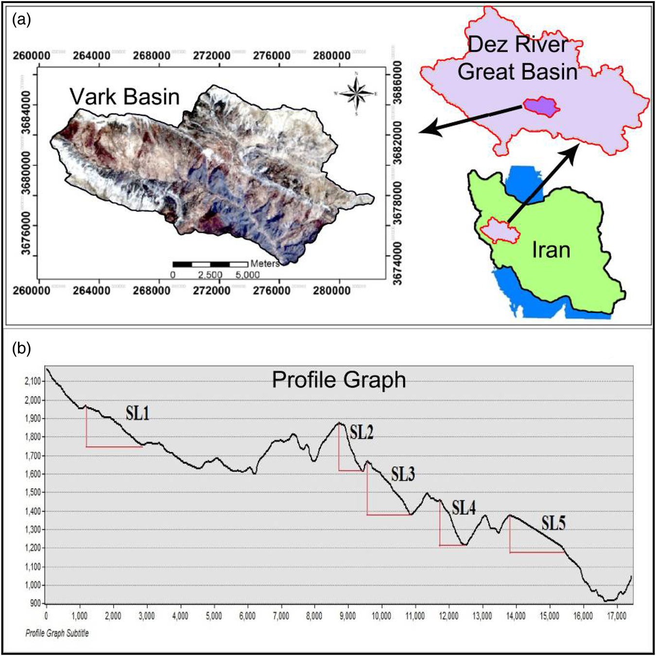
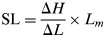
Figure 1 (a) Geographic position of the study area. (b) Length profile of the trunk stream to estimate the stream length index (SL).
2. Data and methods
2.1. Data collection
An excellent way to quickly assess active tectonics is the combination of geomorphic indices with GIS and other remotely sensed data. In this study, the geological data were extracted from source maps at the 1:100,000 scale via the Geological Survey of Iran (GSI 2015). Therefore, topographical layouts with a spatial resolution of ~90 m were derived based on a Global Digital Elevation Model via National Aeronautics and Space Administration (NASA Reference NASA.2011) and were processed into ArcGIS ver. 10.4. In fieldwork, a handheld Trimble GeoXH geographical positioning system was used for general geomorphological investigation. In addition to the geological and topographical data and comprehensive field observations, satellite imagery data by ETM+ (Landsat 8) was used for a precise analysis of the study area via the US Geological Survey (USGS 2016).
2.2. Methodology
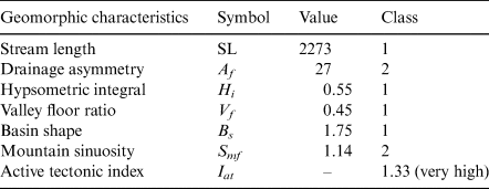
El Hamdouni et al. (Reference El Hamdouni, Irigaray, Fernandez, Chacon and Keller2008) have demonstrated a method for the evaluation of active tectonics based on geomorphologic and topographic characteristics. According to this method and developed procedures by Mahmood & Gloaguen (Reference Mahmood and Gloaguen2012), Markose & Jayappa Reference Markose and Jayappa2013, and Elias et al. (Reference Elias, Sissakian and Al-Ansari2019), some layouts of geomorphologic indices including stream length (SL), drainage asymmetry (Af), hypsometric integral (Hi), the ratio of valley floor (Vf), basin shape (Bs), and mountain sinuosity (Smf) were produced in this study. After the combination of the aforementioned layouts of indices in GIS, an integrated index of relative active tectonics (Iat) was estimated, divided into four intensity classes of very high (1.0 < Iat < 1.5), high (1.5 < Iat < 2.0), moderately (2.0 < Iat < 2.5) and relatively low (Iat > 2.5) activity of tectonics.
2.2.1. SL
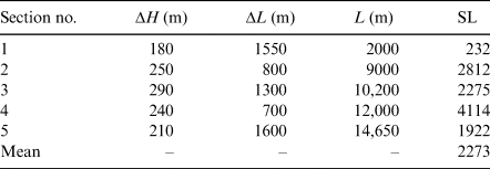
SL describes the topographic gradients in the length of the streams. This index was used to estimate the differential erosion of rocks (Hack Reference Hack1973). It is calculated as the following equation:
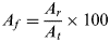
 $${\rm SL} = \displaystyle{{\Delta H} \over {\Delta L}} \times L_m$$
where SL is stream length index, Lm is the total length of trunk stream from the highest point in the upstream to the midpoint of the given basin, and ΔH/ΔL is the slope of stream along the basin representing the elevation gradient (ΔH) with respect to length gradient of the basin (ΔL). When the streams flow along the region with active tectonics, then the values of the SL index will increase (Keller & Pinter Reference Keller and Pinter2002). The SL values are determined using a digital elevation model (DEM) and GIS, indicating three classes of tectonic activity: 1 = active (SL > 500), 2 = semi-active (300 < SL < 500), and 3 = inactive (SL < 300) conditions.
2.2.2. A f
Af evaluates the tectonic sloping/tilting of drainage basins (Hare & Gardner Reference Hare, Gardner, Morisawa and Hack1985). The Af is defined by the following equation:
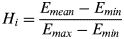
 $$A_f = \displaystyle{{A_r} \over {A_t}} \times 100$$
where Af is drainage asymmetry, Ar is an optional area defined as the right-hand area of the trunk stream facing downstream and At is the total area of the basin. If the Af value is close to 50, then drainage is under stable development with little or no steep slopes. An Af value above or below 50 indicates the sloping/tilting of the drainage basin affected by active tectonics and differential erosion (El Hamdouni et al. Reference El Hamdouni, Irigaray, Fernandez, Chacon and Keller2008). Its three classes of tectonic activity are categorised as 1 = active (Af > 75 or Af < 25), 2 = semi-active (25 < Af < 45 or 55 < Af < 75), and 3 = inactive (45 < Af < 55) conditions.
2.2.3. H i
In the hypsometric curve, Hi is defined as the area below the curve expressing the basin slopes without erosion (Mayer Reference Mayer1990). The Hi is defined by the following equation (Pike & Wilson Reference Pike and Wilson S1971):
 $$H_i = \displaystyle{{E_{mean}-E_{min}} \over {E_{max}-E_{min}}}$$
where the elevation values of the mean (Emean), maximum (Emax), and minimum (Emin) in the basin are obtained from DEM. When a large part of the basin has a level higher than the mean elevation, then it will represent a youth stage of hypsometry and active tectonics. High values of the Hi relate to the convex hypsometric curve (>0.5), indicating the active class (1). Intermediate values are a straight curve (0.4–0.5), indicating the semi-active class (2). Lower values (<0.4) relate to a concave hypsometric curve, indicating the inactive class (3).
2.2.4. V f
Vf is discriminated between V-shaped and U-shaped flat-floored valleys (Bull & McFadden Reference Bull, McFadden and Doehring1977) and is used to identify the tectonically active fronts (Azor et al. Reference Azor, Keller and Yeats2002; Silva et al. Reference Silva, Goy, Zazo and Bardaji2003). It is defined by the following equation:
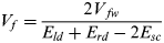 $$V_f = \displaystyle{{2V_{\,fw}} \over {E_{ld} + E_{rd}-2E_{sc}}}$$
where Vfw is the width of the valley floor across the stream, Eld and Erd are the elevations in the left and right valley divides, respectively, and Esc is the elevation in the surface of the valley floor. Deep V-shaped valley (Vf < 1) shows the active down-cutting streams concerning active uplift, while flat-floored U-shaped valley (Vf > 1) shows achievement of the erosion in response to relative tectonic quiescence (Mahmood & Gloaguen Reference Mahmood and Gloaguen2012). In this study, values of the Vf index are determined from DEM, indicating three classes of tectonic activity: 1 = active (Vf < 1), 2 = semi-active (1 < Vf < 2), and 3 = inactive (Vf > 2) conditions.
2.2.5. B s
The horizontal extension of a drainage basin is described by the Bs ratio (Ramirez-Herrera Reference Ramirez-Herrera1998), expressed by the following equation (Faghih et al. Reference Faghih, Nourbakhsh and Kusky2015):
 $$B_s = \displaystyle{{B_l} \over {B_w}}$$
where Bl is the length of the basin from upstream to the outlet, and Bw is the width of the basin across the widest point. The values of the Bs index are categorised as 1 = active (Bs >4 ), 2 = semi-active (3 < Bs < 4), and 3 = inactive (Bs < 3) conditions for relative tectonics.
2.2.6. S mf
The Smf index demonstrates a balance between river slit processes and active tectonics forces over the mountain fronts (Bull & McFadden Reference Bull, McFadden and Doehring1977; Keller Reference Keller and Wallace1986). Bull (Reference Bull2007) has defined the Smf as the following equation (Taromsari et al. Reference Taromsari, Dehbozorgi, Nozaem and Yassaghi2018):
 $$S_{mf} = \displaystyle{{L_j} \over {L_s}}$$
where Lj is the aerial length of mountain front in the length of the mountain–piedmont joint, and Ls is the overall length of the mountain front. An Smf values of less 3 or approximately 1 depend on steep mountain fronts. According to El Hamdouni et al. (Reference El Hamdouni, Irigaray, Fernandez, Chacon and Keller2008), values of the Smf index are categorised into three classes: class 1 (active or very active) must be Smf < 1.0; class 2 (semi-active or moderately active) must be Smf = 1.5–2.5; and class 3 (inactive) must be Smf > 2.5.
2.2.7. Iat
According to El Hamdouni et al. (Reference El Hamdouni, Irigaray, Fernandez, Chacon and Keller2008), Iat is calculated by the average of geomorphic indices/values using the following equation:
 $$I_{at} = \displaystyle{S \over N}$$
where S represents the sum class values of all geomorphic indices, and N is the number of indices, which is equal to six in the present study. Iat can be divided into four classes of intensity, representing very high (1.0 < Iat < 1.5), high (1.5 < Iat < 2.0), moderately (2.0 < Iat < 2.5), and relatively low (Iat > 2.5) activity of local tectonics.
3. Results and discussion
3.1. Geomorphic indices
Geomorphic indices are considered as essential tools for determining tectonic activities in the active areas. In this study, a set of six indices (SL, Af, Hi, Vf, Bs, and Smf) were considered to investigate the Iat in a mountainous basin of Iran.
The SL index is sensitive to and dependent on the variations of the river's slope. However, this dependency and sensitivity can provide a benchmark and an estimation of the relationships that extend between the tectonic activities and the topography of the route (Molin et al. Reference Molin, Pazzaglia and Dramis2004). Accordingly, a modification in the river's slope or gradient can alter the SL as well. If the riverbed undergoes elevation and an increase in its height because of tectonic activity, the riverbed's slope would change accordingly, which would result in a change in the value of the SL index. The best technique to measure the SL is using the length profile of the trunk stream (Burbank & Anderson Reference Burbank and Anderson2001). In the study area, the SL values were calculated within five points along the trunk stream in the places where the profile slope changed (Fig. 1b). On average, the SL value was estimated as equal to 2273 (Table 1). Hence, the study area is classified as having an active class of tectonic activity.
Table 1 Detailed characteristics of ΔH, ΔL, and L to estimate stream length index (SL).
Af can help to identify the tilting and asymmetry of the basin's tectonic activities. With a value of less than 50, it is attributed to the left side (Fig. 2a). It can be noted that the difference between Af and 50 is used to describe the tectonics. A resultant size of this difference of more than 15 indicates tectonically active areas, while values between 7 and 15 refer to semi-active regions, and a value of less than 7 determines inactive regions (Keller & Pinter Reference Keller and Pinter2002). In this research, the Af value was estimated as equal to 27, which indicates a tectonically semi-active region and tilting on the basin's left side (geographically, in the N part).
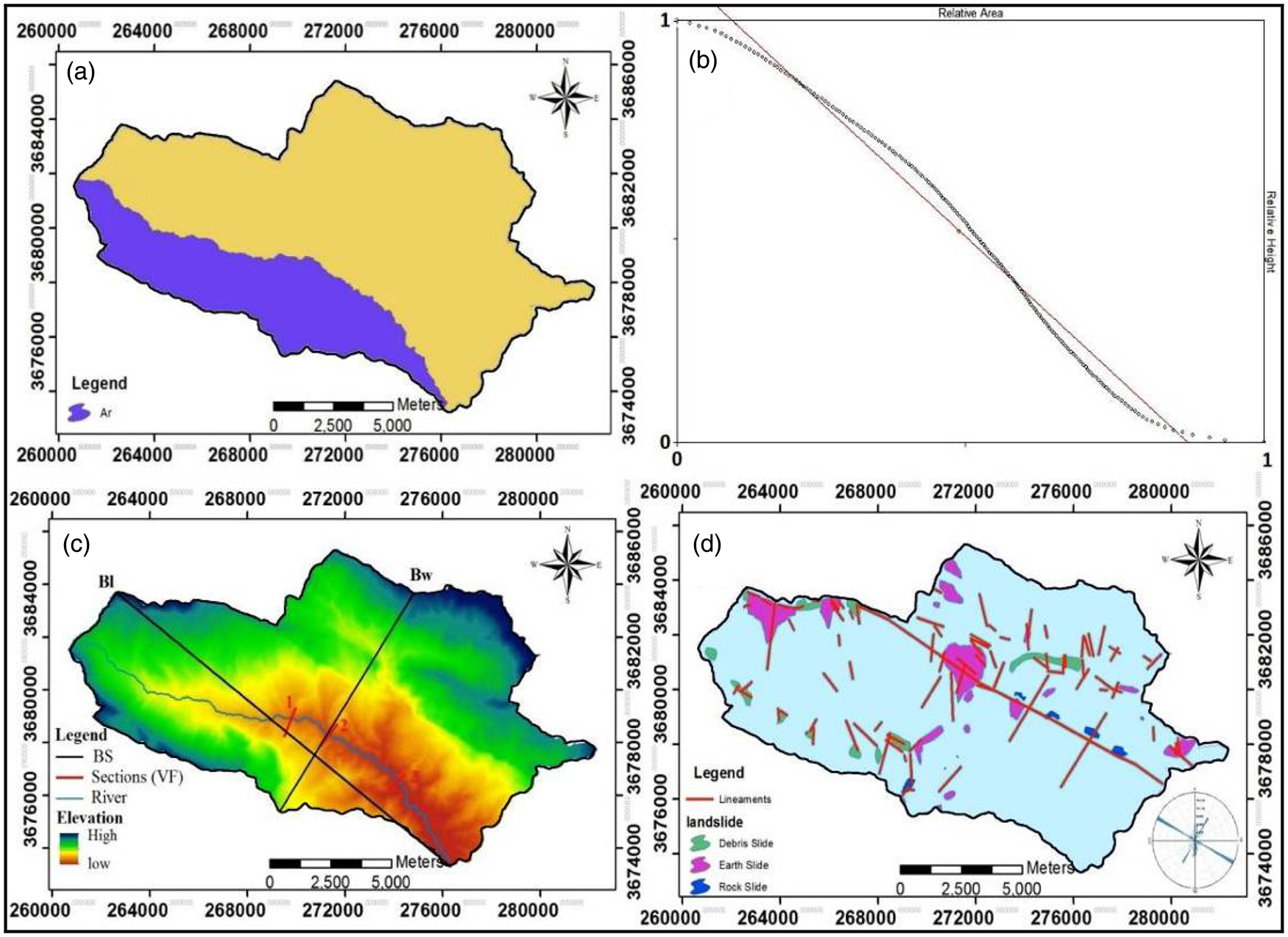
Figure 2 (a) Detailed characteristics of Ar to estimate drainage asymmetry (Af). (b) Hypsometric curve of the study area. (c) Detailed characteristics to estimate the ratio of valley floor (Vf) and index of basin shape (Bs). (d) Distribution of fault lineaments and landslides in the study area.
The Hi index can be used to study the relative changes of the height's ratio to the region. Based on morphometric results, the elevation values of the mean (Emean), maximum (Emax), and minimum (Emin) in the basin were obtained as 1950, 2800, and 900 m asl, respectively. Hence, the mean Hi value for the whole basin was estimated as equal to 0.55, indicating a convex shape and active tectonics. Also, Figure 2b shows that the basin's hypsometric curve is in a developing stage, which is considered as out of sequence maturity based on the underlying main recent fault (MRF) in the region. This corresponds to the results of Obaid & Allen (Reference Obaid and Allen2017) regarding the landscape maturity of various anticlines within the Zagros foothill zone.
Likewise, the convexity in the dimensionless hypsometric curve indicates that the tectonic activity of the basin dominates the erosion activities, while the curve denotes the dominance of the erosion activities over the neo-tectonic activity. According to this figure, it can be claimed that the basin is classified as having an active class of tectonic activity.
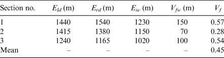
Three valleys were identified and selected along the basin's trunk stream to calculate the Vf (Fig. 2c). Accordingly, by plotting the width profile of the valleys, the values of the maximum height of the two sides of the valley, the height of the valley floor, and, finally, the width of the valley were measured (Table 2). Therefore, the mean values of Vfw , Eld, Erd, and Esc were calculated as 105, 1365, 1360, and 1130 m, respectively, through the central valley along the trunk stream. Hence, the average Vf index was obtained as 0.45, indicating an active class of tectonic activity within the basin as a whole.
Table 2 Detailed characteristics of Eld, Erd, Esc, and VFw to estimate ratio of valley floor (Vf).
The index of Bs reflects the notion that the shape of the stretched basin can be a signal of active tectonics. A reduction in tectonic activity followed by an arrest in elevation would, therefore, cause the erosion processes to gradually make the Bs circular over time. In this research, by determining two parameters of Bl (17.3 km) and Bw (9.9 km), the Bs index was estimated as equal to 1.75, concerning inactive tectonic (Fig. 2c).
The index of Smf relates to equilibrium status between river slit processes and active tectonics. By observing the general pattern of trunk stream along the mountain's front of the basin, the possible stable condition of geomorphic evolution and semi-equilibrium status can be concluded. Also, by calculating the characteristics of Smf (the aerial length of a mountain front of Lj equal to 20,500 m and the overall length of the mountain front of Ls equal to 17,900 m), the index was estimated as being equal to 1.14, which shows that the study area is classified as having a semi-active tectonic state.
Finally, the mean values of the aforementioned geomorphic characteristics and indices in the study area are represented in Table 3. The results presented in Table 3 represent the mean values of the geomorphic characteristics and indices in the study area, which are considered to classify (Iat). For this purpose, the activity class of all indices, as mentioned previously, was categorised to evaluate relative tectonic activity. Then, the mean value of the six classes was used to estimate the index and class of relative tectonic activity (Table 4). The results obtained from the calculation of the geomorphic indices and classes revealed a mean Iat value of 1.33, indicating a very high class of active tectonics. This overall class can be a signal of active tectonics within the Vark basin in the future.
Table 3 Mean values of geomorphic characteristics and indices in the study area.
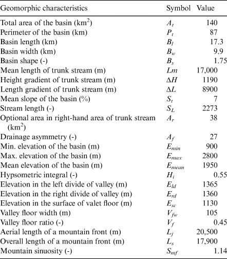
Table 4 Class values of indices and active tectonic index in the study area.
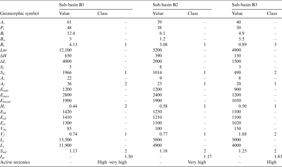
The detailed delineation of different sub-basins in the study area was considered to reveal which part of the basin is prone to having a very high class of active tectonics. In this regard, three sub-basins, entitled B1, B2, and B3, were derived in the Vark basin, with surface areas of 61, 39, and 40 km2, respectively. The B1 sub-basin includes the upstream region of the basin, while the B2 and B3 sub-basins are located in the middle and lowest parts of the basin. The mean values of the geomorphic indices and respective classes in these sub-basins are represented in Table 5. On this basis, the highest and lowest values of geomorphic indices within some parts of the study basin were calculated. The highest values of SL and Bs indices (corresponding to the very high class of active tectonics) were recorded for sub-basins B1 and B2, in the western and northern parts of the basin. Contrarily, the relatively lowest values of Af and Hi indices were estimated for sub-basin B3 in the eastern part of the basin. The B3 sub-basin, located downstream in the study area, has a breadth shape with a lesser Vf. The Smf index was calculated as having moderate values corresponding to the second class of active tectonics. Overall, the mean values of the Iat index for all sub-basins were calculated as 1.50, 1.17, and 1.83, revealing very high and high classes of active tectonics in the whole of the basin. Classification of the Iat index and active tectonics within the sub-basins of the study area are shown in Figure 3a. The figure reveals that the sub-basin B2 is the most prone to active tectonics in the study area. This fact could be observed in its Hi value (0.58) – the highest value in the study area – expressing a very young stage of the geomorphologic process. In addition, the result of active tectonics in the study area can relate to the erosive carbonate lithology of the basin, with karstic phenomena in the drainage system (Fig. 3b); it can also depend on the local and regional evidence of tectonics, such as the MRF in the Zagros mountains. Geographically, the northern segment of the MRF with a NW–SE direction corresponds to the whole of the basin (GSI 2015).
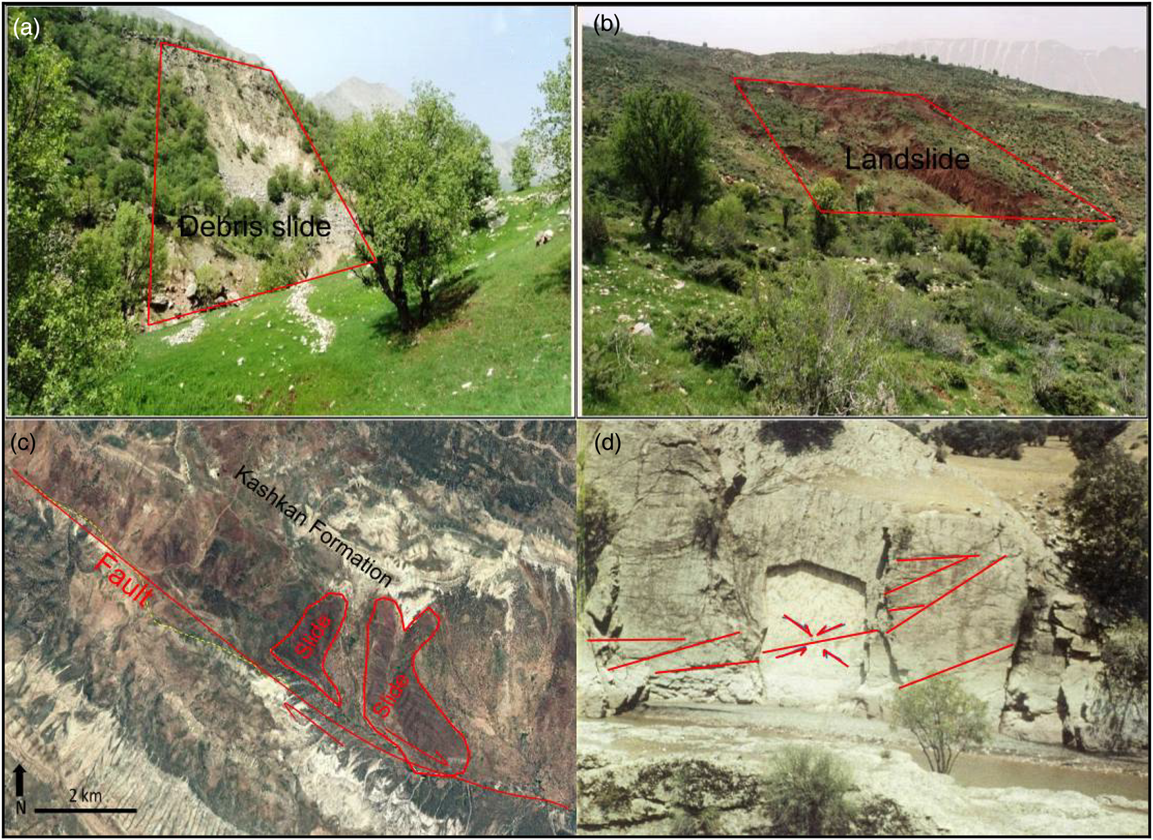
Figure 3 (a) General view of debris slide. (b) Landslide. (c) Inverse faults along the main riverbed of the study area. (d) Complex joints on a carbonate rock.
Table 5 Mean values of geomorphic indices and classes of three sub-basins within the study area.
3.2. Fieldwork observations
The study of the structural status of morphotectonics, such as joints, folds, landslides, faults, and fractures, is essential in confirming the results of the geomorphic indices during the fieldwork. Depending on the carbonate and sandstone rocks and tensions imposed on them, various deformations were observed in the basin, which results in the alternation of structures, related to the northern segment of the MRF. As mentioned in the literature, the MRF cuts through the low-angle thrusts and uplifts in the study area (Talebian & Jackson Reference Talebian and Jackson2002, Reference Talebian and Jackson2004). The MRF is generally a prominent depression in topographic profiles across the Zagros mountains, caused by localised erosion along the steep fault trace, and the presence of folded structures (Allen et al. Reference Allen, Saville, Blanc, Talebian and Nissen2013). For instance, the folds in the basin have the direction of NW–SE and are aligned as regular anticlines and shallow synclines. The folds are affected by deep faults, which were observed as having an asymmetric pattern.
Therefore, using time series of satellite imageries, the prone zones of mass movements were surveyed in the basin. Field observations were performed to register landslides and mass movements. A landslide distribution map is presented in Figure 2d. According to a classification by Varnes (Reference Varnes1978), landslides were categorised into three types of slides – some of these types are presented in Figures 4a, b. On this basis, more than 70% of the study area is a susceptible zone regarding different types of landslides. Furthermore, by processing the satellite images, the fault lineaments in the study area are identified in Figure 2d. All lineaments that stretched along the whole basin were associated with the active tectonics, fractures, and faults that have the most distribution in the N part of the basin, corresponding to the sub-basin B2.
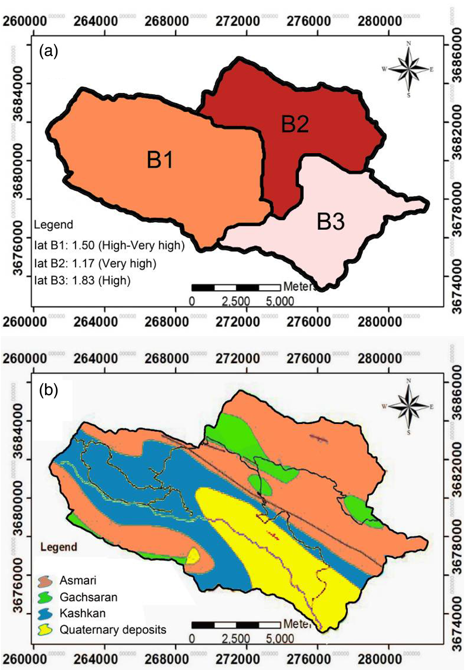
Figure 4 (a) Classification of Iat index and active tectonics within the sub-basins of the study area. (b) Geological units of the study area.
Several faults and fractures influenced a change in the landscape patterns and landslide occurrences. The main trend of faulting within the region was observed in the NW–SE direction, following the dominant physiographic trend of the basin, caused by the northern segment of MRF tectonics. The existence of inverse and thrust faults along the main riverbed of the basin, aged to recent active tectonics in the Quaternary, indicated a pressure mechanism (Fig. 4c). Due to the tension and pressure occurring in the region, a set of shear, tensile, and complex joints have been produced in the study area, which can determine the tectonic activity, especially over the carbonate rocks (Fig. 4d). This can reveal that the local features are strongly linked to an underlying thrust fault, notable by the seismicity records in other researches (e.g., Allen et al. Reference Allen, Saville, Blanc, Talebian and Nissen2013).
4. Conclusion
This research attempted to investigate the tectonic activities in the Vark basin. This mountainous basin is located in the Zagros FTB in northwestern Iran. This study was the first practice to evaluate the tectonic activity in the Vark basin. For this purpose, several indices were utilised to study the tectonic activity of the Vark basin, including SL, Af, Hi, Vf, Bs, and Smf. By averaging the indices, as mentioned previously, the index of active tectonics (Iat) was obtained. The mean SL, Hi, Vf, and Bs values were estimated as 2273, 0.55, 0.45, and 1.75 regarding the active class of tectonic activity, respectively. Therefore, considering the Af and Smf indices, the basin was categorised as having semi-active conditions. Following that, the overall index of Iat with a value of 1.33 represented the very high class of tectonic activity. In addition, the mean values of the Iat index for all sub-basins were calculated as 1.50, 1.17, and 1.83, revealing the very high and high classes of active tectonics in the basin.
On average, the SL values were estimated as 1966, 1014, 490, and 2273 for sub-basins B1, B2, B3, and total basin, respectively; thus, the study area was classified as having an active class of tectonic activity. Investigating the basin's hypsometric curve and Hi values (0.44–0.58) indicated that the dominance of the tectonic activity could be categorised as erosive activities induced by the dynamic processes of geomorphology. The Vf and Bs values indicated a very high class of active tectonics in the whole of the basin, except the sub-basin B3. The B3 sub-basin in the downstream area of the study area has a breadth shape with a lesser Vf . Furthermore, the Af and Smf indices represent a relatively active condition in the basin. This can be related to the erosive carbonate lithology of the study area, with karstic phenomena in the drainage system.
Regarding Iat, the Vark basin can be classified as having a very high class of active tectonics. Concerning the Iat values in the three sub-basins, this can be observed dominantly on the elevated parts and tilting terrain in sub-basin B2. Examination of the morphotectonic signals in the field observations showed that the study area has dynamically active tectonics.
5. Acknowledgements
The authors are grateful to the Islamic Azad University, Khorramabad Branch, which supported the present study as a research project. The authors are also very grateful to Dr Ahmed Kadhim Obaid (reviewer at Earth and Environmental Science Transactions of the Royal Society of Edinburgh) and the anonymous reviewers for contributing some essential comments and technical considerations to the manuscript.


